Antoine-Labelle Regional County Municipality

Last updated

Antoine-Labelle
Quebec MRC Antoine-Labelle location map.svg
Coordinates: 46°53′N75°20′W / 46.883°N 75.333°W / 46.883; -75.333 [1]
CountryFlag of Canada (Pantone).svg  Canada
Province Flag of Quebec.svg  Quebec
Region Laurentides
EffectiveJanuary 1, 1983
County seat Mont-Laurier
Government
[2]
  Type Prefecture
  PrefectRoger Lapointe
Area
  Total16,229.50 km2 (6,266.24 sq mi)
  Land14,976.99 km2 (5,782.65 sq mi)
Population
 (2016) [3]
  Total35,243
  Density2.4/km2 (6/sq mi)
  Change
2011-2016
Increase2.svg 0.2%
  Dwellings
23,399
Time zone UTC−5 (EST)
  Summer (DST) UTC−4 (EDT)
Area code 819
Website www.mrc-
antoine-labelle.qc.ca

Antoine-Labelle is a regional county municipality located in the Laurentides region of Quebec, Canada. Its seat is Mont-Laurier. [2] It is named for Antoine Labelle.

Contents

Subdivisions

There are 28 subdivisions within the RCM: [2]

Demographics

Population

Canada census – Antoine-Labelle community profile
2021 2016 2011
Population36,462 (+3.5% from 2016)35,243 (-+0.2% from 2011)35,159 (+0.5% from 2006)
Land area14,809.85 km2 (5,718.12 sq mi)14,976.99 km2 (5,782.65 sq mi)14,969.05 km2 (5,779.58 sq mi)
Population density2.5/km2 (6.5/sq mi)2.4/km2 (6.2/sq mi)2.3/km2 (6.0/sq mi)
Median age55.6 (M: 55.6, F: 56.0)53.0 (M: 52.8, F: 53.2)49.6 (M: 49.6, F: 49.5)
Private dwellings23,909 (total)  17,839 (occupied)23,399 (total) 23,139 (total) 
Median household income$56,800$46,928$40,301
References: 2021 [4] 2016 [5] 2011 [6] earlier [7] [8]
Historical Census Data - Antoine-Labelle Regional County Municipality, Quebec [9] [10] [3]
YearPop.±%
1991 32,019    
1996 33,904+5.9%
2001 33,456−1.3%
YearPop.±%
2006 34,999+4.6%
2011 35,159+0.5%
2016 35,243+0.2%

Language

Canada Census Mother Tongue - Antoine-Labelle Regional County Municipality, Quebec [9] [10] [3]
CensusTotal
French
English
French & English
Other
YearResponsesCountTrendPop %CountTrendPop %CountTrendPop %CountTrendPop %
2016
34,575
33,630Increase2.svg 0.1%97.3%485Decrease2.svg 2.0%1.4%140Decrease2.svg 17.6%0.4%320Increase2.svg 16.4%0.9%
2011
34,530
33,590Increase2.svg 0.4%97.28%495Increase2.svg 8.8%1.43%170Increase2.svg 47.8%0.49%275Decrease2.svg 47.1%0.80%
2006
34,535
33,445Increase2.svg 5.8%96.84%455Increase2.svg 12.3%1.32%115Increase2.svg 21.1%0.33%520Increase2.svg 108.0%1.51%
2001
32,355
31,605Decrease2.svg 1.6%97.68%405Decrease2.svg 2.4%1.25%95Decrease2.svg 17.4%0.29%250Increase2.svg 28.2%0.77%
1996
32,830
32,105n/a97.79%415n/a1.26%115n/a0.35%195n/a0.59%

Transportation

Access Routes

Highways and numbered routes that run through the municipality, including external routes that start or finish at the county border: [11]

Airports

Protected Areas

Mont-Tremblant National Park
Information Centers/ Camp Areas:

Papineau-Labelle Wildlife Reserve
Information Centers/ Camp Areas:

Rouge-Matawin Wildlife Reserve
Information Centers/ Camp Areas:

Zones d'exploitation contrôlée:

Attractions

See also

Related Research Articles

<span class="mw-page-title-main">Mont-Laurier</span> City in Quebec, Canada

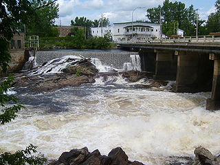
Mont-Laurier is a town and incorporated municipality in northwest Quebec, Canada, located on the banks of the Lièvre River, a tributary of the Ottawa River. Known as the "Capital of the Haute-Laurentides", the motto of the town is Laurus elationis praemium, which translates to "Lift the laurels of reward". The demonym for its inhabitants is Lauriermontois.

The 2000–2006 municipal reorganization in Quebec resulted in large-scale amalgamation of smaller municipalities in Quebec into larger cities. It was undertaken by one administration, and modified and partially undone by its successor.

<span class="mw-page-title-main">Rouge River (Laurentides)</span> River in Laurentides, Quebec (Canada)

The Rouge River is a river flowing in the Laurentides, in the municipality of Grenville-sur-la-Rouge, in the Argenteuil Regional County Municipality, in the administrative region of Laurentides, in the west of Quebec, in western Quebec, Canada.

<span class="mw-page-title-main">Mont-Tremblant</span> City in Quebec, Canada

Mont-Tremblant is a city in the Laurentian Mountains of Quebec, Canada, approximately 130 kilometres (81 mi) northwest of Montreal and 140 kilometres (87 mi) northeast of Ottawa, Ontario. The current municipality with city status was formed in 2000. Mont-Tremblant is most famous for its ski resort, the Mont-Tremblant Ski Resort, which is seven kilometres from the village proper, at the foot of a mountain called Mont Tremblant.

An agglomeration, or urban agglomeration, is an administrative division of Quebec at the local level that may group together a number of municipalities which were abolished as independent entities on 1 January 2002 but reconstituted on 1 January 2006.

<span class="mw-page-title-main">Sir Wilfrid Laurier School Board</span>

The Sir Wilfrid Laurier School Board is a school board headquartered in Rosemère, Quebec in Greater Montreal.

<span class="mw-page-title-main">Nominingue</span> Municipality in Quebec, Canada

Nominingue is a small village and municipality located 200 kilometres (120 mi) north of Montreal, Quebec, Canada, in the Laurentian Mountains. It was formerly called Lac-Nominingue, but changed name on September 16, 2000.

<span class="mw-page-title-main">Mont-Tremblant National Park</span> Provincial park in Quebec, Canada

Mont-Tremblant National Park is a provincial park in Canada located north of the town of Mont-Tremblant, and the village of Saint-Donat and Saint-Côme, in the administrative regions of Laurentides and Lanaudière, in Quebec, in Canada.

<span class="mw-page-title-main">Rivière-Rouge</span> City in Quebec, Canada

Rivière-Rouge is a city located in the Antoine-Labelle Regional County Municipality, Quebec, Canada. The population as of the 2021 Canadian census was 4,631.

<span class="mw-page-title-main">La Macaza</span> Municipality in Quebec, Canada

La Macaza is a municipality and village in the province of Quebec, Canada. The village is located in the Laurentian Mountains, in the Laurentian region, in Antoine-Labelle Regional County Municipality. Its population was 1094 in the 2021 Canadian census.

<span class="mw-page-title-main">Sainte-Anne-du-Lac</span> Municipality in Quebec, Canada

Sainte-Anne-du-Lac is a municipality and village in the Laurentides region of Quebec, Canada, part of the Antoine-Labelle Regional County Municipality.

<span class="mw-page-title-main">Saint-Aimé-du-Lac-des-Îles</span> Municipality in Quebec, Canada

Saint-Aimé-du-Lac-des-Îles is a municipality in the Laurentides region of Quebec, Canada, part of the Antoine-Labelle Regional County Municipality.

The Rouge-Matawin Wildlife Reserve is a Quebec Wildlife Reserve located to the north of Mont-Tremblant National Park, in Quebec, Canada.

The ZEC Collin is a "zone d'exploitation contrôlée" (ZEC) located in the unorganized territory of Lac-Matawin, in Matawinie Regional County Municipality, in the administrative region of Lanaudière, in Quebec, in Canada.

The Zec Normandie is a "zone d'exploitation contrôlée" (ZEC) located in the unorganized territories of the Lac-Bazinet, Lac-De la Bidière, and Lac-Oscar in the Antoine-Labelle Regional County Municipality in the administrative region of Laurentides in Quebec, in Canada.

<span class="mw-page-title-main">Zec Petawaga</span>

The ZEC Petawaga is a "zone d'exploitation contrôlée" located in the area of Mont-Laurier, in Antoine-Labelle Regional County Municipality, in the Laurentides, in Quebec, in Canada. Zec Petawaga straddles the municipality of Ferme-Neuve as well as the unorganized territories of Lac-Marguerite and Lac-Douaire.

The Zec de la Maison-de-Pierre is a "zone d'exploitation contrôlée" (ZEC), located in the municipality of L'Ascension and the unorganized territories of Lac-Douaire, Baie-des-Chaloupes and Lac-de-la-Maison-de-Pierre, in the Antoine-Labelle Regional County Municipality, in the Laurentides region of Quebec, in Canada. This Zec of 800 square kilometres (310 sq mi) was created in 1978.

The ZEC Mazana is a "zone d'exploitation contrôlée" (ZEC) in the unorganized territories of Lac-de-la-Pomme, Lac-de-la-Bidière and Lac-Oscar, in Antoine-Labelle Regional County Municipality, in the administrative region of Laurentides in Quebec, in Canada.

The ZEC Mitchinamecus is a "zone d'exploitation contrôlée" (ZEC) in the unorganized territory of Lac-De La Bidière, in the Antoine-Labelle Regional County Municipality, in the administrative region of Laurentides, in Quebec, in Canada.

Sainte Agathe Academy is a public anglophone primary and secondary school in Sainte-Agathe-des-Monts, Quebec. It is operated by the Sir Wilfrid Laurier School Board.

References

  1. "Banque de noms de lieux du Québec: Reference number 141123". toponymie.gouv.qc.ca (in French). Commission de toponymie du Québec.
  2. 1 2 3 4 "Répertoire des municipalités: Geographic code 790". www.mamh.gouv.qc.ca (in French). Ministère des Affaires municipales et de l'Habitation.
  3. 1 2 3 4 "Census Profile, 2016 Census: Antoine-Labelle, Municipalité régionale de comté [Census division], Quebec". Statistics Canada. 8 February 2017. Retrieved November 27, 2019.
  4. "2021 Community Profiles". 2021 Canadian Census . Statistics Canada. February 4, 2022. Retrieved 2023-10-19.
  5. "2016 Community Profiles". 2016 Canadian Census . Statistics Canada. August 12, 2021. Retrieved 2019-11-27.
  6. "2011 Community Profiles". 2011 Canadian Census . Statistics Canada. March 21, 2019. Retrieved 2014-03-06.
  7. "2006 Community Profiles". 2006 Canadian Census . Statistics Canada. August 20, 2019.
  8. "2001 Community Profiles". 2001 Canadian Census . Statistics Canada. July 18, 2021.
  9. 1 2 Statistics Canada: 1996, 2001, 2006, 2011 census
  10. 1 2 "Antoine-Labelle Regional County Municipality (Code 2479) Census Profile". 2011 census . Government of Canada - Statistics Canada.
  11. Official Transport Quebec Road Map