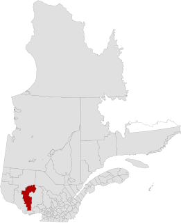
La Vallée-de-la-Gatineau(The Valley of the Gatineau) is a regional county municipality in the Outaouais region of western Quebec, Canada. The seat is in Gracefield. It was incorporated on January 1, 1983 and was named for its location straddling the Gatineau River north of Low.
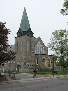
Boulevard Saint-Joseph is a commercial boulevard in the former city of Hull, Quebec. It runs from Boulevard Alexandre-Tache to the boundaries of the city of Gatineau and the suburban town of Chelsea.

Route 108 is a two-lane east/west highway on the south shore of the Saint Lawrence River in the Eastern Townships and Chaudière-Appalaches regions of Quebec, Canada. Its eastern terminus is in Beauceville at the junction of Route 173, and the western terminus is at the junction of Route 112 in Magog.
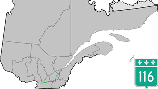
Route 116 is an east/west highway on the south shore of the Saint Lawrence River in Quebec, Canada. Until the mid-1970s it was known as Route 9. Its eastern terminus is in Lévis at the junction of Route 132, and the western terminus is at the junction of Route 134 in Lemoyne part of a concurrency with Route 112 until Saint-Hubert just south of the Saint-Hubert Municipal Airport. The stretch between Lévis and Plessisville does not have much traffic, since Autoroute 20 is not that far from the highway. Between Plessisville and Richmond traffic is heavier as it passes bigger towns, and it is further away from Autoroute 20. From Richmond to Autoroute 20, it is quiet again, before reaching Saint-Hyacinthe, where it becomes a busy four-lane separated highway, going through the growing "South Shore" suburbs of Montreal. From the junction of Autoroute 30 to its western terminus, it is a controlled-access Autoroute-grade expressway. This portion was once envisioned to be part of Autoroute 16. An unofficial extension of Route 116 as thought of by locals, from the western terminus follows the Route 134 limited access expressway to the Jacques Cartier Bridge.

Route 165 is a 68 km north–south highway on the south shore of the Saint Lawrence River in Quebec, Canada. Its southern terminus is in Black Lake, now part of Thetford Mines, at the junction of Route 112 and its northern terminus is in Saint-Louis-de-Blandford at the junction of Autoroute 20. The stretch between Plessisville and Black Lake used to be Route 265 but it was re-numbered Route 165 in the 1990s.

Route 157 is a four-lane north/south highway on the north shore of the Saint Lawrence River in Quebec, Canada. Its northern terminus is in Shawinigan at the junction of Route 153, and the southern terminus is at the junction of Route 138 in Cap-de-la-Madeleine, now part of Trois-Rivières.

Provincial Highway 159 is a two-lane north/south highway on the north shore of the Saint Lawrence River in Quebec, Canada. Its northern terminus is in Saint-Roch-de-Mékinac at the junction of Route 155, and the southern terminus is at the junction of Route 138 in Sainte-Anne-de-la-Pérade.

Route 175 is a major north–south highway on both sides of the St. Lawrence River in Quebec, Canada. Its southern terminus is in Saint-Lambert-de-Lauzon at the junction of Route 218 and its northern terminus is in Saguenay at the junction of Route 172, in the former city of Chicoutimi. Route 175 crosses the Saint Lawrence River on the Quebec Bridge, and a little further north of downtown Quebec City, it merges with Autoroute 73 for about 30 km before continuing through the Laurentides Wildlife Reserve as a two-lane divided highway in Stoneham.

Route 105 is a north-south highway in Quebec, Canada. It runs from Hull, where it is known as Boulevard Saint-Joseph, to Grand-Remous where it ends at Route 117.

Route 117, the Trans Canada Highway Northern Route, is a provincial highway within the Canadian province of Quebec, running between Montreal and the Quebec/Ontario border where it continues as Highway 66 east of Kearns, Ontario. It is an important road as it is the only direct route between southern Quebec and the Abitibi-Témiscamingue region.
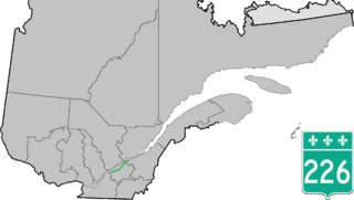
Route 226 is a two-lane east/west highway in Quebec, Canada. Its western terminus is at the junction of Route 132 in Pierreville and its eastern terminus is in Sainte-Croix at the junction of Route 271.

Route 259 is a north/south highway on the south shore of the St. Lawrence River in Quebec, Canada. Its northern terminus is in Nicolet at the junction of Route 132 and its southern terminus is in Notre-Dame-du-Bon-Conseil at the junction of Route 122.

Route 261 is a north/south highway on the south shore of the Saint Lawrence River in Quebec, Canada. Its northern terminus is in Bécancour at the junction of Route 132 and its southern terminus is in Saint-Valère at the junction of Route 161.

Route 283 is a 73 km (?) two-lane north/south highway in the Chaudière-Appalaches region in the province of Quebec, Canada. Its northern terminus is in Montmagny at the junction of Route 132 and its southern terminus is close to Saint-Lucie-de-Beauregard at the junction of Route 204.

Route 241 is a north/south provincial highway on the south shore of the Saint Lawrence River in Quebec. Its northern terminus is in Roxton Falls at the junction of Route 139 and its southern terminus is close to Cowansville, at the junction of Route 139 once again. The highway overlaps both Route 112 and Route 243 in Waterloo located east of Granby and Bromont and just north of Autoroute 10.

Route 202 is an east/west 140-kilometre highway in the Monteregie region of the province of Quebec, Canada. Its western terminus is at the junction of Route 132 in Sainte-Barbe and its eastern terminus is in southern Cowansville at the junctions of Route 104 and Route 139. The highway runs a few kilometres north of the Canada–United States border for most of its length.

Route 247 is a north/south highway on the south shore of the Saint Lawrence River in the Estrie region of Quebec. Its northern terminus is in Magog at the junction of Route 112 and its southern terminus is in Stanstead, at the junction of Autoroute 55 less than 1 kilometre north of the Canada–United States border.

Route 111 is a north/south highway on the north shore of the Saint-Lawrence River in the Abitibi-Témiscamingue region of Quebec, Canada. Its northern terminus is in the municipality of Baie-James at the junction of Route 393, and its southern terminus is in Val-d'Or at the junction of Route 117.

Route 155 is a north/south highway on the north shore of the Saint Lawrence River in Quebec, Canada. Its northern terminus is in Chambord at the junction of Route 169, and the southern terminus is the Piles Bridge in Shawinigan. Previously the highway continued to Autoroute 20 but that section was decommissioned in 2006 when Autoroute 55 was completed.

Route 309 is a provincial highway located in the Outaouais region in western Quebec. It starts at the junction of Autoroute 50 in the Buckingham sector, in the city of Gatineau's east end. It runs mostly parallel to the Du Lièvre River and ends north of Mont-Laurier in the town of Sainte-Anne-du-Lac in the Upper Laurentians.

