
Victoriaville is a town in central Quebec, Canada, on the Nicolet River. Victoriaville is the seat of Arthabaska Regional County Municipality and a part of the Centre-du-Québec (Bois-Francs) region. It was formed in 1993 by the merger of Arthabaska, Saint-Victoire-d'Arthabaska and Victoriaville, with the name of the latter being used for the new merged town.

Arthabaska Regional County Municipality is a regional county municipality located in the Centre-du-Québec region of Quebec. Its seat is Victoriaville.
Arthabaska County is an historical county founded in 1855, in central Quebec, Canada. Its county seat was Arthabaska and the main city was Victoriaville. It was bounded on the northeast by Mégantic County on the southeast Wolfe County, on the southwest by Drummond County and Richmond County and on the northwest by Nicolet County. It was formed from the townships of Warwick, Standold, Arthabaska, Chester-Est, Chester-Ouest and Tingwick, as well as part of the townships of Maddington, Blandford, Horton, Bulstrode, Simpson, and Aston.

Centre-du-Québec is a region of Quebec, Canada. The main centres are Drummondville, Victoriaville, and Bécancour. It has a land area of 6,930.05 square kilometres (2,675.71 sq mi) and a 2016 Census population of 242,399 inhabitants.
Lotbinière was a federal electoral district in Quebec, Canada, that was represented in the House of Commons of Canada from 1867 to 2004.
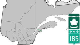
Route 185 is part of the Trans-Canada Highway. It travels from Saint-Antonin to Saint-Louis-du-Ha! Ha!, a distance of about 41 km (25.5 mi). It connects the 2 sections of Autoroute 85 and is the former designation for all of A-85.

Route 263 is a two-lane north/south highway on the south shore of the Saint Lawrence River in Quebec, Canada. Its northern terminus is in the community of Gentilly, part of Bécancour at the junction of Route 132, and the southern terminus is at the junction of Route 161 close to Saint-Augustin-de-Woburn.
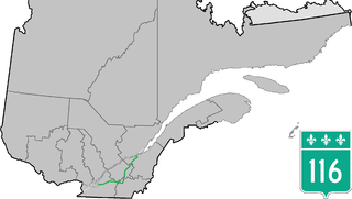
Route 116 is an east/west highway on the south shore of the Saint Lawrence River in Quebec, Canada. Until the mid-1970s it was known as Route 9. Its eastern terminus is in Lévis at the junction of Route 132, and the western terminus is at the junction of Route 134 in Lemoyne part of a concurrency with Route 112 until Saint-Hubert just south of the Saint-Hubert Municipal Airport. The stretch between Lévis and Plessisville does not have much traffic, since Autoroute 20 is not that far from the highway. Between Plessisville and Richmond traffic is heavier as it passes bigger towns, and it is further away from Autoroute 20. From Richmond to Autoroute 20, it is quiet again, before reaching Saint-Hyacinthe, where it becomes a busy four-lane separated highway, going through the growing "South Shore" suburbs of Montreal. From the junction of Autoroute 30 to its western terminus, it is a controlled-access Autoroute-grade expressway. This portion was once envisioned to be part of Autoroute 16. An unofficial extension of Route 116 as thought of by locals, from the western terminus follows the Route 134 limited access expressway to the Jacques Cartier Bridge.

Route 165 is a 68 km north/south highway on the south shore of the Saint Lawrence River in Quebec, Canada. Its southern terminus is in Black Lake, now part of Thetford Mines, at the junction of Route 112 and its northern terminus is in Saint-Louis-de-Blandford at the junction of Autoroute 20. The stretch between Plessisville and Black Lake used to be Route 265 but it was re-numbered Route 165 in the 1990s.

Route 161 is a north/south highway south of the St. Lawrence River in Quebec, Canada. Its current northern terminus is east of the junction of Autoroute 55 in Saint-Wenceslas, and its southern terminus is at the border of Maine in the USA, where it continues as Maine State Route 27.

Route 157 is a four-lane north/south highway on the north shore of the Saint Lawrence River in Quebec, Canada. Its northern terminus is in Shawinigan at the junction of Route 153, and the southern terminus is at the junction of Route 138 in Cap-de-la-Madeleine, now part of Trois-Rivières.
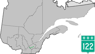
Route 122 is an east/west highway on the south shore of the Saint Lawrence River in Quebec, Canada. Its western terminus is at the junction of Route 132 in Yamaska and the eastern terminus is in Victoriaville at the junction of Route 116. The highway acts mainly as the main link between Drummondville and Sorel-Tracy, and somewhat as a major link between Victoriaville and Drummondville.

Route 277 is a two-lane north/south highway in the Chaudière-Appalaches region in the province of Quebec, Canada. Its northern terminus is in Saint-Henri at the junction of Route 173 and its southern terminus is in Sainte-Aurélie at the junction of Route 275.

Route 226 is a two-lane east/west highway in Quebec, Canada. Its western terminus is at the junction of Route 132 in Pierreville and its eastern terminus is in Sainte-Croix at the junction of Route 271.

Autoroute 85 is a Quebec Autoroute and the route of the Trans-Canada Highway in the province's Bas-Saint-Laurent region, also known as the Autoroute Claude-Béchard. It is currently under construction with committed Federal and Provincial funding for its completion, with an estimated completion date of 2025. Once this upgrade is completed, it will close one of the last gaps in the nearly continuous freeway section of the Trans-Canada between Arnprior, Ontario, and Sutherlands River, Nova Scotia, and for an even longer interprovincial freeway route between Windsor, Ontario and Halifax, Nova Scotia. Running between Rivière-du-Loup and a junction with New Brunswick Route 2 at the Quebec-New Brunswick border, the A-85 when complete will be the only controlled access highway link between the Maritime Provinces and the rest of the country. The A-85 is projected to be approximately 100 km (60 mi) long when construction is complete and is intended to replace Route 185, which has been called one of the deadliest highways in Canada.

Route 236 is a two-lane east/west highway on the south shore of the Saint Lawrence River in the Montérégie region of Quebec, Canada. Its western terminus is in Saint-Stanislas-de-Kostka at the junction of Route 132 and the eastern terminus is at the junction of Route 132 again, in Beauharnois.

Route 134 is a highway in the province of Quebec, running from Candiac on the South Shore of the Saint Lawrence River to Montreal, crossing the river on Jacques Cartier Bridge. On the South Shore, Route 134 is named Taschereau Boulevard, after the prominent Quebec family that included former premier Louis-Alexandre Taschereau. From Jacques Cartier Bridge to the end of the highway at Sherbrooke Street in Montreal, the highway is a one-way pair formed by Papineau Avenue and De Lorimier Avenue.

Route 335 is a north-south route from Montreal north into the Lanaudière region of Quebec.

Route 307 is a provincial road located in the Outaouais region of Quebec. The road runs mostly parallel to the Gatineau River on the eastern side of it. It starts at the corner of Rue Saint-Louis and Boulevard Greber in the Gatineau sector of the city of Gatineau. It runs north of Gatineau and ends in Val-des-Bois at the junction of Route 309 which runs from the Buckingham sector north into the Upper Laurentians.
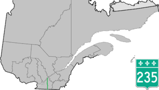
Route 235 is a Quebec provincial highway located in the Estrie and Montérégie regions in the southeastern part of the province. The highway runs from the Morses Line Border Crossing at the Canada-United States border in Saint-Armand to Yamaska. It overlaps Route 239 in Massueville and Route 137 and Route 116 in Saint-Hyacinthe, Quebec. A small portion of the highway near its northern terminus runs parallel to the Yamaska River.

