
Drummondville is a city in the Centre-du-Québec region of Quebec, located east of Montreal on the Saint-François River. The population as of the Canada 2021 Census was 79,258. The mayor of Drummondville is Stéphanie Lacoste.
Centre-du-Québec is a region of Quebec, Canada. The main centres are Drummondville, Victoriaville, and Bécancour. It has a land area of 6,930.05 square kilometres (2,675.71 sq mi) and a 2016 Census population of 242,399 inhabitants.

Route 232 is a two-lane east/west provincial highway on the south shore of the St. Lawrence River in the Bas-Saint-Laurent region of Eastern Quebec, Canada. Its eastern terminus is in Rimouski at the junction of Route 132 and the western terminus is at the junction of Route 289 in Rivière-Bleue. The route temporarily becomes A-85 along a 3 kilometre section through Cabano.

Route 265 is a two-lane north/south highway on the south shore of the Saint Lawrence River in Quebec, Canada. Its northern terminus is in Deschaillons-sur-Saint-Laurent at the junction of Route 132, and the southern terminus is at the junction of Route 165 in Plessisville. It used to continue up to Black Lake at the junction of Route 112, but the segment between Plessisville and Black Lake was later re-numbered to Route 165 in the 1990s.

Route 271 is a two-lane north/south highway on the south shore of the Saint Lawrence River in Quebec, Canada. Its northern terminus is in Sainte-Croix at the junction of Route 132, and the southern terminus is at the junction of Route 173 in Saint-Georges.

Route 161 is a north/south highway south of the St. Lawrence River in Quebec, Canada. Its current northern terminus is at Autoroute 20 in Sainte-Eulalie, just east of the junction of Autoroute 55, while its southern terminus is at the border of Maine in the USA, where it continues as Maine State Route 27. Previously the highway continued to Route 155 in Saint-Célestin, but that section was decommissioned in 2006 when Autoroute 55 was completed.

Route 162 is a short 24 km highway on the south shore of the St. Lawrence River in Quebec, Canada, linking Autoroute 20 in Saint-Louis-de-Blandford and Victoriaville, at the junction of Route 122.

Route 157 is a four-lane north–south highway on the north shore of the Saint Lawrence River in Quebec, Canada. Its northern terminus is in Shawinigan at the junction of Route 153, and the southern terminus is at the junction of Route 138 in Cap-de-la-Madeleine, now part of Trois-Rivières.

Route 143 is a north/south highway on the south shore of the Saint Lawrence River. Until the mid-1970s when the province decided to renumber all highways other than autoroutes, it was known as Route/Highway 5. Its northern terminus is in Saint-François-du-Lac, at the junction of Route 132, and the southern terminus is in Stanstead, at the border with Vermont where the road continues past the Derby Line–Stanstead Border Crossing as U.S. Route 5 through Derby Line to New Haven, Connecticut.
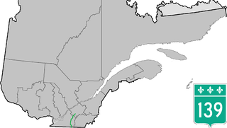
Route 139 is a north/south highway on the south shore of the Saint Lawrence River. Its northern terminus is in Saint-Nicéphore, now part of Drummondville, at the junction of Route 143, and the southern terminus is in Abercorn at the border with Richford, Vermont at the Richford–Abercorn Border Crossing.
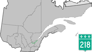
Route 218 is a two-lane east/west highway in Quebec, Canada. Its western terminus is at the junction of Route 132 in Saint-Pierre-les-Becquets and its eastern terminus is in Saint-Michel-de-Bellechasse at the junction of Route 281.

Route 226 is a two-lane east/west highway in Quebec, Canada. Its western terminus is at the junction of Route 132 in Pierreville and its eastern terminus is in Sainte-Croix at the junction of Route 271.

Route 259 is a north–south highway on the south shore of the St. Lawrence River in Quebec, Canada. Its northern terminus is in Nicolet at the junction of Route 132 and its southern terminus is in Notre-Dame-du-Bon-Conseil at the junction of Route 122.

Route 283 is a 73 km (?) two-lane north/south highway in the Chaudière-Appalaches region in the province of Quebec, Canada. Its northern terminus is in Montmagny at the junction of Route 132 and its southern terminus is close to Saint-Lucie-de-Beauregard at the junction of Route 204.
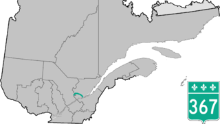
Route 367 is a 100 km two-lane north–south highway on the north shore of the Saint Lawrence River in Quebec, Canada. Although it is technically a north–south highway, long stretches of the road are east–west. Its northern/western terminus is close to Lac-aux-Sables at the junction of Route 363 and the southern/eastern terminus is in Saint-Augustin-de-Desmaures at the junction of Route 138. Route 367 used to end in Rivière-à-Pierre, but in the late 1990s, the stretch between Rivière-à-Pierre and the junction of Route 363 was added.

Route 239 is a north–south highway on the south shore of the Saint Lawrence River. Its northern terminus is at Route 133 in Sainte-Victoire-de-Sorel and its southern terminus is at Saint-Germain-de-Grantham at the junction of Route 122.

Route 309 is a provincial highway located in the Outaouais region in western Quebec. It starts at the junction of Autoroute 50 in the Buckingham sector, in the city of Gatineau's east end. It runs mostly parallel to the Du Lièvre River and ends north of Mont-Laurier in the town of Sainte-Anne-du-Lac in the Upper Laurentians.
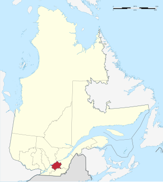
Saint-Cyrille-de-Wendover is a Quebec municipality located in the Drummond Regional County Municipality just east of Drummondville in the Centre-du-Quebec region. The population as of the Canada 2011 Census was 4,389. The town is located alongside the Rivière des Saults.

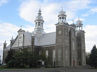
Notre-Dame-du-Bon-Conseil is a village municipality in Drummond Regional County Municipality in the Centre-du-Quebec region of Quebec. The population as of the Canada 2016 Census was 1,557. The community is completely encircled by the parish municipality of Notre-Dame-du-Bon-Conseil.

The Nicolet Southwest River is a tributary on the west bank of the Nicolet River. It empties into the municipality of Nicolet, in the Nicolet-Yamaska Regional County Municipality (MRC), in the administrative region of Centre-du-Québec, in Quebec, in Canada.

