Berthierville (also called Berthier-en-haut, and legally called Berthier before 1942) is a town located between Montreal and Trois-Rivières on the north shore of the Saint Lawrence River in Quebec, Canada. Berthierville is the seat of D'Autray Regional County Municipality, and is served by Autoroute 40, and is the junction of Routes 138 and 158. It is surrounded by the parish municipality of Sainte-Geneviève-de-Berthier.

The Laurentides is a region of Quebec. While it is often called the Laurentians in English, the region includes only part of the Laurentian mountains. It has a total land area of 20,779.19 km2 (8,022.89 sq mi) and its population was 589,400 inhabitants as of the 2016 Census.
Autoroute 15 is a highway in western Quebec, Canada. It is also called the Décarie Expressway (English) or Autoroute Décarie (French) between the Turcot and Décarie Interchanges in Montreal and the Laurentian Autoroute (English) or Autoroute des Laurentides (French) north of Autoroute 40. It was, until the extension of Autoroute 25 was opened in 2011, the only constructed north-south autoroute to go out of Montreal on both sides. A-15 begins at the end of Interstate 87 at the United States border at Saint-Bernard-de-Lacolle and extends via Montreal to Sainte-Agathe-des-Monts with an eventual continuation beyond Mont-Tremblant. The total length of A-15 is currently 164 km (101.9 mi), including a short concurrency with Autoroute 40 that connects the two main sections. It is one of the few autoroutes in Quebec that does not have any spinoff highways.
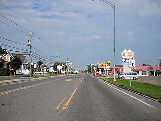
Autoroute 50 is an Autoroute in western Quebec, Canada. It links Canada's National Capital Region (Gatineau) and the Greater Montreal area (Mirabel).
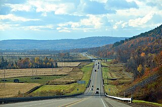
Autoroute 31 (A-31) is an Autoroute in the region of Lanaudière in Quebec. Constructed in 1966, A-31 primarily links Joliette with A-40 and in turn to Montreal, Trois-Rivières, and other points served by Quebec's autoroute system. A-31 is only 14 km (8.7 mi) long, making it one of the shortest autoroutes in the province. It is multiplexed with Route 131 for its entire length.
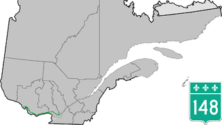
Route 148 is an east-west highway in Quebec, Canada. It runs from junction of Autoroute 13 and Autoroute 440 in Laval in the Montreal region to the Ontario-Quebec border in L'Isle-aux-Allumettes in western Quebec. For most of its length, Route 148 follows the north shore of the Ottawa River where it acted as the principal route between communities in the Outaouais region until the completion of Autoroute 50 in 2012. At the Ontario-Quebec border in L'Isle-aux-Allumettes Route 148 continues into Ontario as Highway 148.
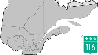
Route 116 is an east/west highway on the south shore of the St. Lawrence River in Quebec, Canada. It runs between Route 134 in Longueuil and Route 132 in Lévis, connecting the south shore areas of Montreal and Quebec City; it also serves the administrative regions of Montérégie, Centre-du-Québec, Estrie and Chaudière-Appalaches. Until the mid-1970s it was known as Route 9 between Le Moyne and Saint-Simon; Route 32 between Saint-Simon and Richmond; and Route 5 between Richmond and Saint-Nicolas.

Route 175 is a major north–south highway on both sides of the St. Lawrence River in Quebec, Canada. Its southern terminus is in Saint-Lambert-de-Lauzon at the junction of Route 218 and its northern terminus is in Saguenay at the junction of Route 172, in the former city of Chicoutimi. Route 175 crosses the Saint Lawrence River on the Quebec Bridge, and a little further north of downtown Quebec City, it merges with Autoroute 73 for about 30 km before continuing through the Laurentides Wildlife Reserve as a two-lane divided highway in Stoneham.

Route 117, the Trans Canada Highway Northern Route, is a provincial highway within the Canadian province of Quebec, running between Montreal and the Quebec/Ontario border where it continues as Highway 66 east of McGarry, Ontario. It is an important road since it is the only direct route between southern Quebec and the Abitibi-Témiscamingue region.

Route 335 is a north-south regional route located on the north shore of the St. Lawrence River. from Montreal It serves the administrative regions of Montreal, Laval, Laurentides, and Lanaudière. It is the only secondary road whose route crosses the Island of Montreal. Between Autoroute 440 in Laval and Côte-Saint-Louis Road in Terrebonne, Route 335 is located in the right-of-way of the future Autoroute 19.

Route 201 is a north/south provincial highway within the Canadian province of Quebec, running between Route 202 in Franklin and Route 342 in Rigaud. Its total length is approximately 70 kilometres.
Argenteuil is a provincial electoral district in the Laurentides region of Quebec, Canada that elects members to the National Assembly of Quebec. It notably includes the municipalities of Saint-Colomban, Lachute and Brownsburg-Chatham.

The Sir Wilfrid Laurier School Board is a school board headquartered in Rosemère, Quebec in Greater Montreal.

Route 309 is a provincial highway located in the Outaouais region in western Quebec. It starts at the junction of Autoroute 50 in the Buckingham sector, in the city of Gatineau's east end. It runs mostly parallel to the Du Lièvre River and ends north of Mont-Laurier in the town of Sainte-Anne-du-Lac in the Upper Laurentians.
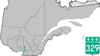
Route 329 is a provincial highway in the Laurentides and Lanaudière regions of Quebec, serving a large portion of the popular tourist area as well as numerous lakes and cottage areas in the Middle and Upper Laurentians. Beginning at the junction of Route 148 just east of Lachute, it ends 93 kilometers further north at the junction of Route 125 in Saint-Donat, just south of Mont-Tremblant National Park. It is briefly concurrent with Route 364 in Morin-Heights and Route 117 in Sainte-Agathe-des-Monts.

Route 337 is a Quebec provincial highway situated in the Lanaudière region. It runs from the junctions of Autoroute 25 and Route 344 in Terrebonne and ends in Saint-Jean-de-Matha at Route 131. It overlaps Route 335 and Route 158 near Saint-Lin–Laurentides as well as Route 125 in Sainte-Julienne, Route 341 and Route 348 in Rawdon and Route 343 in Saint-Alphonse-Rodriguez.
The North Shore is the general term for the northern suburbs of Montreal. The North Shore is located in southwestern Quebec on the northern shore Rivière des Mille Îles, opposite the Île Jésus. It consists of twenty municipalities that belong to the Laurentides and Lanaudière administrative regions. While the city of Laval is commonly associated with the North Shore, it is not considered part of the North Shore because of its status as an island.
The Centre de services scolaire des Samares is a francophone school district headquartered in Saint-Félix-de-Valois, in the Canadian province of Quebec. It comprises several primary schools and high schools across municipalities in the Lanaudière region. The commission is overseen by a board of elected school trustees.
Joliette High School is a public anglophone secondary school in Joliette, Quebec. Operated by the Sir Wilfrid Laurier School Board, it is the sole anglophone high school in Lanaudière. As of 2017 it has about 265 students.


