Autoroute 20 is a Quebec Autoroute, following the Saint Lawrence River through one of the more densely populated parts of Canada, with its central section forming the main route of the Trans-Canada Highway from the A-25 interchange to the A-85 interchange. At 585 km (363.5 mi), it is the longest Autoroute in Quebec. It is one of two main links between Montreal and Quebec City; the other is the A-40.
Autoroute 40, officially known as Autoroute Félix-Leclerc outside Montreal and Metropolitan Autoroute/Autoroute Métropolitaine within Montreal, is an Autoroute on the north shore of the St. Lawrence River in the Canadian province of Quebec. It is one of the two major connections between Montreal and Quebec City, the other being Autoroute 20 on the south shore of the St. Lawrence. Autoroute 40 is currently 347 km (215.6 mi) long. Between the Ontario–Quebec boundary and the interchange with Autoroute 25, the route is signed as part of the Trans-Canada Highway.
Autoroute 15 is a highway in western Quebec, Canada. It was, until the extension of Autoroute 25 was opened in 2011, the only constructed north-south autoroute to go out of Montreal on both sides. A-15 begins at the end of Interstate 87 at the United States border at Saint-Bernard-de-Lacolle and extends via Montreal to Sainte-Agathe-des-Monts with an eventual continuation beyond Mont-Tremblant. The total length of A-15 is currently 164 km (101.9 mi), including a short concurrency with Autoroute 40 that connects the two main sections. This is one of the few autoroutes in Quebec that does not have any spinoff highways.
Autoroute 50 is an Autoroute in western Quebec, Canada. It links Canada's National Capital Region (Gatineau) and the Greater Montreal area (Mirabel).

Route 132 is the longest highway in Quebec. It follows the south shore of the Saint Lawrence River from the border with the state of New York in the hamlet of Dundee, west of Montreal to the Gulf of Saint Lawrence and circles the Gaspé Peninsula. This highway is known as the Navigator's Route. It passes through the Montérégie, Centre-du-Québec, Chaudière-Appalaches, Bas-Saint-Laurent and Gaspésie regions of the province.
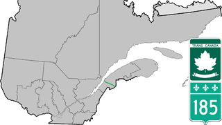
Route 185 is part of the Trans-Canada Highway. It travels from Saint-Antonin to Saint-Louis-du-Ha! Ha!, a distance of about 41 km (25.5 mi). It connects the 2 sections of Autoroute 85 and is the former designation for all of A-85.

Autoroute 10 (A-10) is an Autoroute of Quebec in Canada that links greater Montreal to key population centres in Montérégie and Estrie, including Brossard, Saint-Jean-sur-Richelieu, Granby, and Sherbrooke.
Autoroute 73 is an autoroute in Quebec, Canada. Following a northwest-southeast axis perpendicular to the Saint Lawrence River, the A-73 provides an important freeway link with regions north and south of Quebec City, the capital of the province. It also intersects with Autoroute 20 and Autoroute 40 - one of only three Quebec autoroutes to do so. The A-73 begins less than 40 kilometres from the U.S. border in Quebec's Beauce region, traverses metropolitan Quebec City, and ends in the Laurentian Mountains. Civic, political, and business leaders in regions north and south of the A-73's termini have lobbied the Quebec government to extend the autoroute. While the four-laning of Route 175 to Saguenay has alleviated concerns in the north about safety and connectivity, Quebecers in the Beauce continue to advocate for extending the A-73 to the U.S. border, towards the Armstrong–Jackman Border Crossing and U.S. Route 201 within Maine.
Autoroute 55 is an important north–south Autoroute and the only one running in that direction in central Quebec. It is the longest north-south Autoroute, beginning as the continuation of I-91 at the Canada–United States border near Stanstead and continuing to Shawinigan, where it downgrades to Route 155. The total length of A-55 is currently 247 km (153.5 mi) long, including concurrencies with Autoroute 10, Autoroute 20 and Autoroute 40.
Route 136 (R-136), formerly Autoroute 720, known as the Ville-Marie Expressway (English) or Autoroute Ville-Marie (French) is an Autoroute highway in the Canadian province of Quebec that is a spur route of Autoroute 20 in Montreal. Its western terminus is located at the Turcot Interchange, a junction with Autoroute 15 and Autoroute 20, and its eastern terminus is near the Jacques Cartier Bridge, where the highway merges with Notre-Dame Street. The Autoroute Ville-Marie designation is named after the downtown borough of Ville-Marie, through which the expressway is routed. It was designated Autoroute 720 until 2021 when it was renamed to Route 136.
Autoroute 30 (A-30), or the Autoroute de l'Acier is an Autoroute in Quebec, Canada. Construction of the A-30 dates back to the early days of autoroute construction in the 1960s. Originally called Highway 3, the A-30 was designed to replace Route 132 as the main artery linking the communities along the South Shore of the St. Lawrence River. The A-30 was originally intended to begin at the U.S. border near Dundee and end at Saint-Pierre-les-Becquets. In the late 1970s an eight-year moratorium on new autoroute construction in favour of public transport by the Parti Québécois prevented implementation of that plan.

Autoroute 410 is a short peri-urban multilane highway in Sherbrooke, Quebec. It is currently a branch from Autoroute 10 to its terminus east of Lennoxville. The road was named for Jacques O'Bready, the former mayor of Sherbrooke and president of the Commission municipale du Québec, in March 2007. Before then, the road was known as the Autoroute University.

Autoroute 19, also known as Autoroute Papineau, is an autoroute in Quebec. It crosses the Rivière des Prairies via the Papineau-Leblanc Bridge, connecting the borough of Ahuntsic-Cartierville in Montreal and the Duvernay neighbourhood in Laval.
Autoroute 740 is a Quebec Autoroute in metropolitan Quebec City, Canada. A spur route of Autoroute 40, the A-740 runs for 7.3 km (4.5 mi) on a north-south axis through the boroughs of Sainte-Foy–Sillery–Cap-Rouge and Les Rivières, with interchanges at the A-440 at exit 4 and the A-40 at exit 9.

Route 112 is a busy east–west highway on the south shore of the Saint Lawrence River in Quebec, Canada. Its eastern terminus is in Frampton at the junction of Route 275, and the western terminus is in Downtown Montreal, after crossing the Victoria Bridge. The stretch between Vallée-Jonction and Sherbrooke is a very busy highway as it is the main link between the southern regions of Quebec, in particular the Beauce region and the Eastern Townships. Between Sherbrooke and Marieville there is less traffic, since Autoroute 10 is in close proximity to the highway. From Marieville to Montreal it is a very busy highway, in most parts a four-lane separated highway, upgraded to freeway standards in certain places.
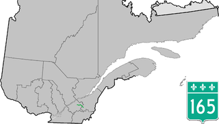
Route 165 is a 68 km north–south highway on the south shore of the Saint Lawrence River in Quebec, Canada. Its southern terminus is in Black Lake, now part of Thetford Mines, at the junction of Route 112 and its northern terminus is in Saint-Louis-de-Blandford at the junction of Autoroute 20. The stretch between Plessisville and Black Lake used to be Route 265 but it was re-numbered Route 165 in the 1990s.
Autoroute 955 is a short 14.7-kilometre (9.1 mi) two-lane highway which links Autoroute 20 in Sainte-Eulalie with Saint-Albert.

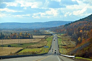
Autoroute 85 is a Quebec Autoroute and the route of the Trans-Canada Highway in the province's Bas-Saint-Laurent region, also known as Autoroute Claude-Béchard. It is currently under construction with committed Federal and Provincial funding for its completion, with an estimated completion date of 2026. Once this upgrade is completed, it will close the last gap in the nearly continuous freeway section of the Trans-Canada between Arnprior, Ontario, and Antigonish, Nova Scotia, and for an even longer interprovincial freeway route between Windsor, Ontario and Halifax, Nova Scotia. Running between Rivière-du-Loup and a junction with New Brunswick Route 2 at the Quebec-New Brunswick border, A-85 when complete will be the only controlled access highway link between the Maritime Provinces and the rest of the country. A-85 is projected to be approximately 100 km (60 mi) long when construction is complete and is intended to replace Route 185, which has been called one of the deadliest highways in Canada.
Autoroute 540 (Vaudreuil-Dorion) was a short spur route that connected Autoroute 20 to Autoroute 40, providing a direct freeway link from Windsor, Ontario to Quebec City, Rivière-du-Loup, and points east through A-40, as A-20 currently has several at-grade intersections in Vaudreuil-Dorion as a multi-lane divided road. A-540 was the shortest numbered Autoroute.


