Stoke, Quebec

Last updated • 1 min readFrom Wikipedia, The Free Encyclopedia

Stoke
VillageStoke.jpg
Stoke's village
Stoke Quebec location diagram.png
Location within Le Val-Saint-François RCM
Canada Southern Quebec location map.png
Red pog.svg
Stoke
Location in southern Quebec
Coordinates: 45°32′N71°48′W / 45.533°N 71.800°W / 45.533; -71.800 [1]
Country Canada
Province Quebec
Region Estrie
RCM Le Val-Saint-François
ConstitutedJanuary 1, 1864
Government
[2]
  MayorLuc Cayer
   Federal riding Compton—Stanstead
   Prov. riding Mégantic
Area
  Total252.90 km2 (97.65 sq mi)
  Land255.12 km2 (98.50 sq mi)
 There is an apparent contradiction between two authoritative sources
Population
 (2021) [3]
  Total3,014
  Density11.8/km2 (31/sq mi)
  Pop 2016-2021
Increase2.svg 2%
  Dwellings
1,283
Time zone UTC−5 (EST)
  Summer (DST) UTC−4 (EDT)
Postal code(s)
Area code 819
HighwaysQc216.svg R-216
Website stoke.ca OOjs UI icon edit-ltr-progressive.svg

Stoke is a municipality in Le Val-Saint-François in the Estrie region of Quebec in Canada.

Contents

The Sentiers de l'Estrie hiking trails provide access to Mount Chapman, the highest peak of the Stoke Mountains, and Bald Peak, at an altitude of 650 metres (2,130 ft).

History

Stoke mountains Stoke mountains - panoramio (1).jpg
Stoke mountains

Stoke was first known in 1792 as Cowan's Clearance in memory of Moses Cowan, who surveyed the land for the British Crown. The Township was abandoned until 1837 due to a lack of interest, and passed into the hands of the British American Land Company. In 1856, thanks to the Stoke Road and the road that would soon lead to Sherbrooke, the territory was opened to settlement.

A testimony to the repeated efforts of its citizens, Stoke boasts the neo-Gothic Saint-Philémon Church (1892).

Demographics

Population

Canada census – Stoke, Quebec community profile
2021 2016 2011
Population3,014 (2% from 2016)2,955 (6.9% from 2011)2,765 (2.1% from 2006)
Land area255.12 km2 (98.50 sq mi)255.46 km2 (98.63 sq mi)256.52 km2 (99.04 sq mi)
Population density11.8/km2 (31/sq mi)11.6/km2 (30/sq mi)10.8/km2 (28/sq mi)
Median age43.6 (M: 44,0, F: 43.2)42.8 (M: 43.6, F: 41.8)41.9 (M: 41.8, F: 42.0)
Private dwellings1,283 (total) 1,258 (total) 1,118 (total) 
Median household income$88,000$73,685$61,562
References: 2021 [4] 2016 [5] 2011 [6] earlier [7] [8]
Historical Census Data - Stoke, Quebec
YearPop.±%
1871 508    
1881 771+51.8%
1891 1,133+47.0%
1901 1,512+33.5%
1911 1,313−13.2%
1921 1,527+16.3%
1931 1,371−10.2%
1941 1,280−6.6%
1951 1,248−2.5%
1956 1,230−1.4%
1961 1,310+6.5%
1966 1,356+3.5%
YearPop.±%
1971 1,453+7.2%
1976 1,801+24.0%
1981 2,079+15.4%
1986 2,142+3.0%
1991 2,287+6.8%
1996 2,409+5.3%
2001 2,606+8.2%
2006 2,708+3.9%
2011 2,765+2.1%
2016 2,955+6.9%
2021 3,014+2.0%
Source: Statistics Canada [3] [9]

Language

Mother tongue (2021) [4]

LanguagePopulationPct (%)
French only2,92597.0%
English only451.5%
English and French250.8%
Non-official languages200.7%

Local government

List of former mayors:

See also

Related Research Articles

<span class="mw-page-title-main">Avignon Regional County Municipality</span> Regional county municipality in Quebec, Canada

Avignon is a regional county municipality located in the Gaspésie–Îles-de-la-Madeleine region of Quebec, Canada. Its seat and largest city is Carleton-sur-Mer.

<span class="mw-page-title-main">Beauharnois-Salaberry Regional County Municipality</span> Regional county municipality in Quebec, Canada

Beauharnois-Salaberry is a regional county municipality in the Montérégie region of Quebec, Canada. Its seat is Beauharnois.

<span class="mw-page-title-main">Deux-Montagnes Regional County Municipality</span> Regional county municipality in Quebec, Canada

Deux-Montagnes is a regional county municipality in the Laurentides region of Quebec, Canada. It is located immediately north of Laval on the north shore of the Rivière des Mille-Îles and on the north shore of the Lake of Two Mountains. Its seat and largest city is Saint-Eustache.

<span class="mw-page-title-main">La Mitis Regional County Municipality</span> Regional county municipality in Quebec, Canada

La Mitis is a regional county municipality in the Bas-Saint-Laurent region in eastern Quebec, Canada on the Gaspé peninsula. It is named for the Mitis River which has its source in the region and flows through the central part of the region before emptying into the Saint Lawrence River.

<span class="mw-page-title-main">L'Assomption Regional County Municipality</span> Regional county municipality in Quebec, Canada

L'Assomption is a regional county municipality in the Lanaudière region of Quebec, Canada. The seat is L'Assomption. L'Assomption is located directly north of the city of Montreal.

<span class="mw-page-title-main">Le Domaine-du-Roy Regional County Municipality</span> Regional county municipality in Quebec, Canada

Le Domaine-du-Roy(The King's Domain) is a regional county municipality in the Saguenay-Lac-Saint-Jean region of Quebec, Canada. Its seat is in Roberval, and it is named for the King of France, who owned the land at the time of the colonization of Quebec.

<span class="mw-page-title-main">Le Haut-Richelieu Regional County Municipality</span> Regional county municipality in Quebec, Canada

Le Haut-Richelieu Regional County Municipality(Upper Richelieu) is a regional county municipality in the Montérégie region in southwestern Quebec, Canada. Its seat is in Saint-Jean-sur-Richelieu. It is named for the Richelieu River which runs south-north through it.

<span class="mw-page-title-main">Les Basques Regional County Municipality</span> Regional county municipality in Quebec, Canada

Les Basques(the Basques) is a regional county municipality in the Bas-Saint-Laurent region in eastern Quebec, Canada. It is located on the south bank of the Saint Lawrence River halfway between Rimouski and Rivière-du-Loup.

<span class="mw-page-title-main">Les Maskoutains Regional County Municipality</span> Regional county municipality in Quebec, Canada

Les Maskoutains is a regional county municipality in the Montérégie region in southwestern Quebec, Canada. Its seat is in Saint-Hyacinthe.

<span class="mw-page-title-main">L'Île-d'Orléans Regional County Municipality</span> Regional county municipality in Quebec, Canada

L'Île-d'Orléans is a regional county municipality in central Quebec, Canada, in the Capitale-Nationale region. Its seat is Sainte-Famille-de-l'Île-d'Orléans. The population in the 2016 census was 7,082 people.

<span class="mw-page-title-main">Manicouagan Regional County Municipality</span> Regional county municipality in Quebec, Canada

Manicouagan is a regional county municipality in the Côte-Nord region of Quebec, Canada. It is located on the north shore of the Saint Lawrence River with its seat in Baie-Comeau. It was created in 1981, and named after the Manicouagan River.

<span class="mw-page-title-main">La Matanie Regional County Municipality</span> Regional county municipality in Quebec, Canada

La Matanie is a regional county municipality, located in the Bas-Saint-Laurent region of Quebec, in Canada. From January 1, 1982, to March 9, 2013, it was known as Matane.

<span class="mw-page-title-main">Rimouski-Neigette Regional County Municipality</span> Regional county municipality in Quebec, Canada

Rimouski-Neigette is a regional county municipality in the Bas-Saint-Laurent region of Quebec, Canada.

<span class="mw-page-title-main">Témiscouata Regional County Municipality</span> Regional county municipality in Quebec, Canada

Témiscouata is a regional county municipality in the Bas-Saint-Laurent region of Quebec, Canada. It is located southeast of Rivière-du-Loup, bordering New Brunswick, and is centred on Lake Témiscouata. Its seat is Témiscouata-sur-le-Lac.

<span class="mw-page-title-main">Le Haut-Saint-Laurent Regional County Municipality</span> Regional county municipality in Quebec, Canada

Le Haut-Saint-Laurent(Upper Saint Lawrence) is a regional county municipality in southwestern Quebec, Canada, in the Montérégie region. Its seat is in Huntingdon. It is named for the Saint Lawrence River, which forms its western and its northwestern boundaries.

<span class="mw-page-title-main">Saint-Henri, Chaudière-Appalaches, Quebec</span> Municipality in Quebec, Canada

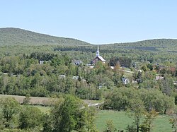
Saint-Henri is a municipality of 5,611 people, 20 km south of Lévis, in the Bellechasse Regional County Municipality. It is sometimes known as Saint-Henri-de-Lévis, and was historically known as Saint-Henri-de-Lauzon.

<span class="mw-page-title-main">Saint-Édouard-de-Fabre</span> Parish municipality in Quebec, Canada

Saint-Édouard-de-Fabre is a parish municipality in western Quebec, Canada, in the Témiscamingue Regional County Municipality.

<span class="mw-page-title-main">Sainte-Anne-du-Lac</span> Municipality in Quebec, Canada

Sainte-Anne-du-Lac is a municipality and village in the Laurentides region of Quebec, Canada, part of the Antoine-Labelle Regional County Municipality.

<span class="mw-page-title-main">Mont-Blanc, Quebec</span> Municipality in Quebec, Canada

Mont-Blanc, is a municipality in the Laurentides region of Quebec, Canada, part of the Les Laurentides Regional County Municipality.

<span class="mw-page-title-main">Saint-Alphonse, Gaspésie–Îles-de-la-Madeleine, Quebec</span> Municipality in Quebec, Canada

Saint-Alphonse is a municipality in Quebec, Canada.

References

  1. "Banque de noms de lieux du Québec: Reference number 270853". toponymie.gouv.qc.ca (in French). Commission de toponymie du Québec.
  2. 1 2 "Répertoire des municipalités: Geographic code 42005". www.mamh.gouv.qc.ca (in French). Ministère des Affaires municipales et de l'Habitation.
  3. 1 2 3 "Data table, Census Profile, 2021 Census of Population - Stoke, Municipalité (MÉ) [Census subdivision], Quebec". 9 February 2022.
  4. 1 2 "2021 Community Profiles". 2021 Canadian Census . Statistics Canada. February 4, 2022. Retrieved 2024-02-18.
  5. "2016 Community Profiles". 2016 Canadian Census . Statistics Canada. August 12, 2021. Retrieved 2020-08-25.
  6. "2011 Community Profiles". 2011 Canadian Census . Statistics Canada. March 21, 2019. Retrieved 2020-08-25.
  7. "2006 Community Profiles". 2006 Canadian Census . Statistics Canada. August 20, 2019.
  8. "2001 Community Profiles". 2001 Canadian Census . Statistics Canada. July 18, 2021.
  9. 1996, 2001, 2006, 2011, 2016, 2021 census