Quebec Route 112

Last updated

Qc112.svg

Route 112

Route 112-QC.png
Route information
Maintained by Transports Québec
Length319.0 km [1]  (198.2 mi)
HistoryQC-1 (1952).svg Route 1 (Saint-HubertVallée-Jonction)
Major junctions
West endQc138.svg R-138 in Montreal
Major intersectionsQuebec Autoroute 20.svgQc132.svg A-20  / R-132 in Saint-Lambert
Quebec Autoroute 30.svgQc116.svgQc134.svg A-30  / R-116  / R-134 in Longueuil
Qc133.svg R-133 in Richelieu
Qc137.svgQc139.svg R-137  / R-139 in Granby
Quebec Autoroute 10.svgQuebec Autoroute 55.svgQc108.svgQc141.svg A-10  / A-55  / R-108  / R-141 in Magog
Quebec Autoroute 10.svgQuebec Autoroute 55.svg A-10  / A-55 in Sherbrooke
Quebec Autoroute 410.svgQuebec Autoroute 610.svgQc143.svg A-410  / A-610  / R-143 in Sherbrooke
Qc161.svg R-161 in Weedon and Beaulac-Garthby
Qc165.svg R-165 in Thetford Mines
Qc173.svg R-173 in Vallée-Jonction
Quebec Autoroute 73.svg A-73 in Saints-Anges
East endQc275.svg R-275 in Frampton
Location
Country Canada
Province Quebec
Highway system
Qc111.svg R-111 Qc113.svg R-113

Route 112 is a busy east/west highway on the south shore of the Saint Lawrence River in Quebec, Canada. Its eastern terminus is in Frampton at the junction of Route 275, and the western terminus is in Downtown Montreal (at the corner of Peel Street and Sherbrooke Street), after crossing the Victoria Bridge. The stretch between Vallée-Jonction and Sherbrooke is a very busy highway as it is the main link between the southern regions of Quebec, in particular the Beauce region and the Eastern Townships. Between Sherbrooke and Marieville there is less traffic, since Autoroute 10 is in close proximity to the highway. (Before Autoroute 10 was put in service in the early 1960s, Route 1 (now Route 112) was the main link between Montreal and the Eastern Townships; see paragraph below.) From Marieville to Montreal it is a very busy highway, in most parts a four-lane separated highway, upgraded to freeway standards in certain places.

Contents

Route 112 is Granby's main street (rue Principale), Magog's main street (rue Principale), and Sherbrooke's main street (rue King). It has been the road connecting most of the Eastern Townships to Montreal for decades as Route 1.

Municipalities along Route 112

Route 112 near Magog, Quebec Route 112 (Magog).jpg
Route 112 near Magog, Quebec
Route 112 near Thetford Mines Route 112 (Thetford Mines).jpg
Route 112 near Thetford Mines

Major intersections

RCMLocationkm [2] miExitDestinationsNotes
Montreal Montreal 0.00.0Qc138.svg Rue Sherbrooke (R-138) / Rue Peel R-112 western terminus and follows Rue Peel; R-112 is unsigned
0.60.37 Boulevard René-Lévesque
0.90.56Qc136.svg To R-136 west / Rue Saint-Antoine
1.81.1 Rue Wellington / Rue Peel R-112 follows Rue Wellington; to A-10 east
2.21.4Crosses Canal de Lachine
2.51.6Rue Bridge / Rue Wellington R-112 follows Rue Bridge
St. Lawrence River 3.8–
6.2
2.4–
3.9
Pont Victoria (Victoria Bridge)
Longueuil Saint-Lambert 6.44.0Qc132.svgQuebec Autoroute 20.svg R-132  / A-20  Varennes, La Prairie, U.S.A. A-20 exit 78; R-112 is signed east of A-20 / R-132
7.54.7 Avenue Victoria
Longueuil 8.85.51Qc134.svgQc116.svg R-134 (Boulevard Taschereau) / R-116 begins La Prairie, Pont Champlain, Pont Jacques-Cartier Interchange; R-116 western terminus; west end of R-116 concurrency; exit numbers follow R-116
10.2–
10.8
6.3–
6.7
2Boulevard ÉdouardInterchange
13.38.34Quebec I-300-1.svg Chemin de Chambly / Boulevard Cousineau Saint-Hubert Airport
Qc116.svg R-116 east (Boulevard Sir-Wilfrid-Laurier) Beloeil, Saint-Hyacinthe
Interchange; east end of R-116 concurrency; R-112 follows Boulevard Cousineau
18.211.3Quebec Autoroute 30.svg A-30  Sorel-Tracy, Vaudreuil-Dorion A-30 exit 73
La Vallée-du-Richelieu Carignan 24.815.4Qc223.svg R-223 north Beloeil West end of R-223 concurrency
Chambly 27.116.8Boulevard FréchetteTo A-35
29.518.3Qc223.svg R-223 south Saint-Jean-sur-Richelieu Interchange; east end of R-223 concurrency
Rouville Richelieu 30.619.0Qc133.svgQuebec Autoroute 10.svg R-133 to A-10  Saint-Mathias-sur-Richelieu, Saint-Jean-sur-Richelieu
Marieville 37.023.0Qc227.svgQuebec Autoroute 10.svg R-227 to A-10  Saint-Jean-Baptiste, Marieville Centre-Ville, Mont-Saint-Grégoire
Rougemont 43.727.2Qc229.svg R-229 north Rougemont, Saint-Jean-Baptiste
46.528.9Qc231.svg R-231 north Saint-Damase, Saint-Hyacinthe
Saint-Césaire 51.231.8Qc233.svgQuebec Autoroute 10.svg R-233 to A-10  Sainte-Brigide-d'Iberville, Farnham, Saint-Hyacinthe
Saint-Paul-d'Abbotsford 58.336.2Qc235.svgQuebec Autoroute 10.svg R-235 to A-10  Ange-Gardien, Saint-Pie
La Haute-Yamaska Granby 68.942.8Qc137.svg R-137 north Sainte-Cecile-de-Milton, Saint-Hyacinthe
71.044.1Qc139.svgQuebec Autoroute 10.svg R-139 to A-10  Roxton Pond, Cowansville Interchange under construction [3]
Waterloo 93.358.0Qc241.svgQc243.svg R-241 north / R-243 north Roxton Falls, Valcourt West end of R-241 / R-243 concurrency
94.258.5Qc241.svg R-241 south Bromont, Cowansville East end of R-241 concurrency
Shefford 96.059.7Qc243.svgQuebec Autoroute 10.svg R-243 south to A-10  Lac-Brome East end of R-243 concurrency
Memphrémagog Saint-Étienne-de-Bolton 106.766.3Quebec Autoroute 10.svg To A-10  Saint-Étienne-de-Bolton A-10 exit 100
Eastman 112.069.6Qc245.svgQuebec Autoroute 10.svg R-245 south to A-10  Bolton-Est, Mansonville
Magog 121.3–
121.7
75.4–
75.6
Qc141.svg R-141 south Orford
Quebec Autoroute 10.svg A-10  Sherbrooke, Montreal
A-10 exit 115; R-141 signed as south but heads north (circular route)
126.778.7Qc141.svg R-141 (Rue Merry) to R-247
127.479.2Qc108.svg R-108 east (Rue Princeipale) Sainte-Catherine-de-Hatley
130.781.2Quebec Autoroute 55.svgQuebec Autoroute 10.svg A-55 to A-10  Sherbrooke, Montreal, Stanstead A-55 exit 33
132.882.5Quebec Autoroute 10.svgQuebec Autoroute 55.svg A-10 west / A-55 south Montreal, Stanstead A-10 exit 123; no eastbound exit to A-10 west / A-55 south; west end of A-10 / A-55 concurrency; R-112 follows A-10 / A-55 service roads
City of Sherbrooke 133.883.1Qc249.svg R-249 north Saint-Denis-de-Brompton A-10 exit 123
137.085.1Quebec Autoroute 10.svgQuebec Autoroute 55.svg A-10 east / A-55 north Sherbrooke, Drummondville A-10 exit 128; east end of A-10 / A-55 concurrency
148.092.0Quebec Autoroute 410.svgQuebec Autoroute 10.svgQuebec Autoroute 55.svg A-410 to A-10  / A-55  Montreal, Drummondville, Cookshire-Eaton A-410 exit 4
150.693.6Boulevard Jacques-CartierAccess to Université de Sherbrooke and R-216 south
153.895.6Qc143.svg Rue des Grandes-Fourches (R-143)
155.4–
155.5
96.6–
96.6
Qc216.svg 12e Avenue / 13e Avenue (R-216)One-way pair
160.499.7Quebec Autoroute 610.svgQuebec Autoroute 10.svgQuebec Autoroute 55.svg A-610 to A-10  / A-55  Montreal, Drummondville Roundabout; A-610 eastern terminus
Le Haut-Saint-François East Angus 172.7107.3Qc214.svgQc253.svg R-214 east / R-253 south East Angus, Cookshire, Lac-Mégantic
175.4109.0Rue Saint-JeanPartially grade-separated
Dudswell 188.1116.9Qc255.svg R-255  Asbestos, Bishopton
Weedon 204.9127.3Qc257.svg R-257 south Gould, Fontainebleau West end of R-257 concurrency
205.9127.9Qc257.svg R-257 north Ham-Sud East end of R-257 concurrency
213.0132.4Qc161.svg R-161 south Lac-Mégantic West end of R-161 concurrency
Les Appalaches Beaulac-Garthby 220.4137.0Qc161.svg R-161 north Victoriaville East end of R-161 concurrency
Disraeli 230.2143.0Qc263.svg R-263 north Saint-Jacques-le-Majeur-de-Wolfestown, Saint-Fortunat West end of R-263 concurrency
231.1143.6Qc263.svg R-263 south Sainte-Praxède, Lambton, Grand lac Saint François East end of R-263 concurrency
Thetford Mines 251.0156.0Qc165.svg R-165 north (Rue Saint-Désiré) Saint-Ferdinand, Plessisville
258.8160.8Qc267.svg R-267 (Rue Saint-Alphonse) Saint-Jean-de-Brébeuf, Centre-Ville, Adstock
266.2165.4Qc269.svg R-269 north (Rue Poirier) Pontbriand, Saint-Agapit West end of R-269 concurrency
267.8166.4Qc269.svg R-269 south (Rue Saint-Georges) Adstock East end of R-269 concurrency
Thetford MinesSaint-Pierre-de-Broughton boundary273.8170.1Qc271.svg R-271 north Saint-Pierre-de-Broughton, Saint-Jacques-de-Leeds West end of R-271 concurrency
Sacré-Cœur-de-Jésus 278.5173.1Qc271.svg R-271 south Sainte-Clotilde-de-Beauce, Saint-Éphrem-de-Beauce East end of R-271 concurrency
Beauce-Centre Saint-Frédéric 295.7183.7Qc276.svg R-276 east Saint-Joseph-de-Beauce
La Nouvelle-Beauce Vallée-Jonction 305.5189.8Qc173.svg R-173 south (Rue Principale) Saint-Georges West end of R-173 concurrency
305.8190.0Qc173.svg R-173 north Lévis East end of R-173 concurrency
Vallée-JonctionSaints-Anges boundary308.4191.6Quebec Autoroute 73.svg A-73  Québec, Saint-Georges A-73 exit 81
Frampton 319.7198.7Qc275.svg R-275  Saint-Malachie, Sainte-Marguerite, Saint-Odilon-de-Cranbourne R-112 eastern terminus
1.000 mi = 1.609 km; 1.000 km = 0.621 mi

See also

Related Research Articles

<span class="mw-page-title-main">Quebec Route 138</span> Highway in Quebec

Route 138 is a major highway in the Canadian province of Quebec, following the entire north shore of the Saint Lawrence River past Montreal to the temporary eastern terminus in Kegashka on the Gulf of Saint Lawrence. The western terminus is in Elgin, at the border with New York State south-west of Montreal. Part of this highway is known as the Chemin du Roy, or King's Highway, which is one of the oldest highways in Canada.

<span class="mw-page-title-main">Quebec Autoroute 10</span> Highway in Quebec

Autoroute 10 (A-10) is an Autoroute of Quebec in Canada that links greater Montreal to key population centres in Montérégie and Estrie, including Brossard, Saint-Jean-sur-Richelieu, Granby, and Sherbrooke.

<span class="mw-page-title-main">Quebec Route 148</span> Highway in Quebec

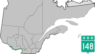
Route 148 is an east-west highway in Quebec, Canada. It runs from junction of Autoroute 13 and Autoroute 440 in Laval in the Montreal region to the Ontario-Quebec border in L'Isle-aux-Allumettes in western Quebec. For most of its length, Route 148 follows the north shore of the Ottawa River where it acted as the principal route between communities in the Outaouais region until the completion of Autoroute 50 in 2012. At the Ontario-Quebec border in L'Isle-aux-Allumettes Route 148 continues into Ontario as Highway 148.

<span class="mw-page-title-main">Quebec Route 216</span> Highway in Quebec

Route 216 is a two-lane east/west highway in Quebec, Canada, which starts in Sainte-Catherine-de-Hatley in the Estrie region at the junction of Route 108 and ends in Sainte-Perpétue in Chaudière-Appalaches at the junction of Route 204.

<span class="mw-page-title-main">Quebec Route 271</span> Highway in Quebec

Route 271 is a two-lane north/south highway on the south shore of the Saint Lawrence River in Quebec, Canada. Its northern terminus is in Sainte-Croix at the junction of Route 132, and the southern terminus is at the junction of Route 173 in Saint-Georges.

<span class="mw-page-title-main">Quebec Route 108</span> Highway in Quebec

Route 108 is a two-lane east/west highway on the south shore of the Saint Lawrence River in the Eastern Townships and Chaudière-Appalaches regions of Quebec, Canada. Its eastern terminus is in Beauceville at the junction of Route 173, and the western terminus is at the junction of Route 112 in Magog.

<span class="mw-page-title-main">Quebec Route 116</span> Highway in Quebec

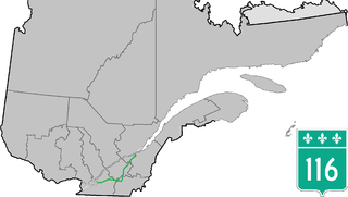
Route 116 is an east/west highway on the south shore of the St. Lawrence River in Quebec, Canada. It runs between Route 134 in Longueuil and Route 132 in Lévis, connecting the south shore areas of Montreal and Quebec City; it also serves the administrative regions of Montérégie, Centre-du-Québec, Estrie and Chaudière-Appalaches. Until the mid-1970s it was known as Route 9 between Le Moyne and Saint-Simon; Route 32 between Saint-Simon and Richmond; and Route 5 between Richmond and Saint-Nicolas.

<span class="mw-page-title-main">Quebec Route 141</span> Highway in Quebec

Route 141 is a north/south highway in Quebec on the south shore of the Saint Lawrence River. Its northern terminus is in Magog at the junction of Route 112 and Autoroute 10, and the southern terminus is in Saint-Herménégilde at the United States border in Canaan, Vermont.

<span class="mw-page-title-main">Quebec Route 133</span> Highway in Quebec

Route 133 is a historic and heritage road of the Estrie and Montérégie regions in the province of Quebec, with north/south orientation and located on the eastern shore of the Richelieu River. Its northern terminus is in Sorel-Tracy, on the south shore of the Saint Lawrence River. The southern terminus is in Saint-Armand at the United States border with Vermont, close to Highgate Springs, where it continues southward past the Highgate Springs–St. Armand/Philipsburg Border Crossing as Interstate 89. Prior to the 1970s, the portion between the international border and Saint-Jean-sur-Richelieu was known as Route 7, which served as a continuation of US 7.

<span class="mw-page-title-main">Quebec Route 241</span> Highway in Quebec

Route 241 is a north/south provincial highway on the south shore of the Saint Lawrence River in Quebec. Its northern terminus is in Roxton Falls at the junction of Route 139 and its southern terminus is close to Cowansville, at the junction of Route 139 once again. The highway overlaps both Route 112 and Route 243 in Waterloo located east of Granby and Bromont and just north of Autoroute 10.

<span class="mw-page-title-main">Quebec Route 247</span> Highway in Quebec

Route 247 is a north/south highway on the south shore of the Saint Lawrence River in the Estrie region of Quebec. Its northern terminus is in Magog at the junction of Route 112 and its southern terminus is in Stanstead, at the junction of Autoroute 55 less than 1 kilometre north of the Canada–United States border.

<span class="mw-page-title-main">Quebec Route 249</span> Highway in Quebec

Route 249 is a two-lane north/south highway on the south shore of the Saint Lawrence River in Quebec, Canada. Its northern terminus is in Val-des-Sources at the junction of Route 255, and the southern terminus is at the junction of Route 112 close to Magog.

<span class="mw-page-title-main">Quebec Autoroute 610</span> Highway in Quebec

Autoroute 610 (A-610), also known as Autoroute Louis Bilodeau, is a short spur autoroute serving the eastern and northern suburbs of Sherbrooke, Quebec, Canada. It bypasses Sherbrooke's city centre to the north and connects the A-55 and A-10 to Route 112, a primary regional link to East Angus, Thetford Mines, and Lac-Mégantic.

<span class="mw-page-title-main">Quebec Route 307</span> Highway in Quebec

Route 307 is a provincial road located in the Outaouais region of Quebec. The road runs mostly parallel to the Gatineau River on the eastern side of it. It starts at the corner of Rue Saint-Louis and Boulevard Greber in the Gatineau sector of the city of Gatineau. It runs north of Gatineau and ends in Val-des-Bois at the junction of Route 309 which runs from the Buckingham sector north into the Upper Laurentians.

<span class="mw-page-title-main">Quebec Route 227</span> Highway in Quebec

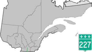
Route 227 is a provincial highway located in the Montérégie region of Quebec. The highway runs from Venise-en-Québec at the junction of Route 202 in the northwestern shores of Lake Champlain and ends at the junction of Autoroute 20 in Sainte-Marie-Madeleine, near Mont-Saint-Hilaire. It briefly overlaps Route 229 in Saint-Jean-Baptiste.

<span class="mw-page-title-main">Montreal and Southern Counties Railway</span> Former interurban streetcar line in Quebec

The Montreal and Southern Counties Railway Company was an electric interurban streetcar line that served communities between Montreal and Granby from 1909 until 1956. A second branch served the city of Longueuil. Operated by the Canadian National Railway (CN), the M&SCRC ran trams on tracks in the street in Montreal and closer South Shore communities, and on separate right of way in rural areas.

<span class="mw-page-title-main">Marieville, Quebec</span> City in Quebec, Canada

Marieville is a city in the Canadian province of Quebec. It is located within the Rouville Regional County Municipality in the Montérégie region about 30 kilometres (19 mi) east of Montreal. The population as of the Canada 2011 Census was 10,094.

<span class="mw-page-title-main">Saint-Alphonse-de-Granby</span> Municipality in Quebec, Canada

Saint-Alphonse-de-Granby is a municipality in the Canadian province of Quebec, located within La Haute-Yamaska Regional County Municipality. The population as of the 2011 Canadian Census was 3,125.

References

  1. Ministère des transports, "Distances routières", page 57-58, Les Publications du Québec, 2005
  2. Google (April 12, 2023). "Route 112 in Quebec" (Map). Google Maps . Google. Retrieved April 12, 2023.
  3. rédaction, La (24 May 2022). "[Route 139 à Granby] Amélioration à venir dans la gestion de la circulation". On The Road (in French). Retrieved 23 March 2023.