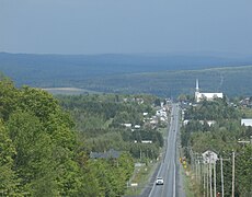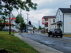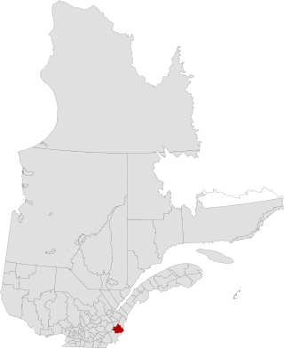
Beauce-Sartigan is a regional county municipality in the Chaudière-Appalaches region of Quebec, Canada. The county seat is Saint-Georges.
Autoroute 73 is an autoroute in Quebec, Canada. Following a northwest-southeast axis perpendicular to the St. Lawrence River, the A-73 provides an important freeway link with regions north and south of Quebec City, the capital of the province. It also intersects with Autoroute 20 and Autoroute 40 - one of only three Quebec autoroutes to do so. The A-73 begins less than 40 kilometres from the U.S. border in Quebec's Beauce region, traverses metropolitan Quebec City, and ends in the Laurentian Mountains. Civic, political, and business leaders in regions north and south of the A-73's termini have lobbied the Quebec government to extend the autoroute. While the four-laning of Route 175 to Saguenay has alleviated concerns in the north about safety and connectivity, Quebecers in the Beauce continue to advocate for extending the A-73 to the U.S. border, towards the Armstrong–Jackman Border Crossing and U.S. Route 201 within Maine.

Route 173 (Route-du-Président-Kennedy) is a major north/south highway on the south shore of the St. Lawrence River in Quebec, Canada, named after the assassinated American president, John F. Kennedy. Its southern terminus is at the Armstrong–Jackman Border Crossing in Saint-Théophile in the hamlet of Armstrong, at the border with Maine, and its northern terminus is in Lévis at the junction of Route 132. Route 173 follows the Chaudière River for most of its course, from Saint-Georges, down to Scott, where the route takes a more northeastern route towards Lévis, crossing the Etchemin River in the municipality of Saint-Henri-de-Lévis.

Route 216 is a two-lane east/west highway in Quebec, Canada, which starts in Sainte-Catherine-de-Hatley in the Estrie region at the junction of Route 108 and ends in Sainte-Perpétue in Chaudière-Appalaches at the junction of Route 204.

Route 204 is a finite two-lane east–west highway on the south shore of the Saint Lawrence River in Quebec. It is one of the longest secondary highways in the province. Its eastern terminus is in Saint-Jean-Port-Joli at the junction of Route 132 and the western terminus is in Lac-Mégantic at the junction of Route 161. Although it is numbered as an east–west highway, the road follows a north–south course from Saint-Jean-Port-Joli to Saint-Pamphile, where it then follows a mostly southwest–northeast course until Saint-Georges, where after crossing the Chaudière River, follows it in a north–south course until the source of the Chaudiere in Megantic Lake, in Lac-Mégantic.

Route 263 is a two-lane north/south highway on the south shore of the Saint Lawrence River in Quebec, Canada. Its northern terminus is in the city of Bécancour at the junction of Route 132, and the southern terminus is at the junction of Route 161 close to Saint-Augustin-de-Woburn.
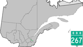
Route 267 is a two-lane north/south highway on the south shore of the Saint Lawrence River in Quebec, Canada. Its northern terminus is in Plessisville at the junction of Route 265, and the southern terminus is at the junction of Route 269 in Adstock.

Route 271 is a two-lane north/south highway on the south shore of the Saint Lawrence River in Quebec, Canada. Its northern terminus is in Sainte-Croix at the junction of Route 132, and the southern terminus is at the junction of Route 173 in Saint-Georges.
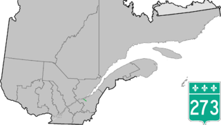
Route 273 is a short 21 km long, two-lane north–south highway on the south shore of the Saint Lawrence River in Quebec, Canada. Its northern terminus is in Saint-Antoine-de-Tilly at the junction of Route 132, and the southern terminus is at the junction of Route 269 near Saint-Gilles.

Route 108 is a two-lane east/west highway on the south shore of the Saint Lawrence River in the Eastern Townships and Chaudière-Appalaches regions of Quebec, Canada. Its eastern terminus is in Beauceville at the junction of Route 173, and the western terminus is at the junction of Route 112 in Magog.

Route 116 is an east/west highway on the south shore of the St. Lawrence River in Quebec, Canada. It runs between Route 134 in Longueuil and Route 132 in Lévis, connecting the south shore areas of Montreal and Quebec City; it also serves the administrative regions of Montérégie, Centre-du-Québec, Estrie and Chaudière-Appalaches. Until the mid-1970s it was known as Route 9 between Le Moyne and Saint-Simon; Route 32 between Saint-Simon and Richmond; and Route 5 between Richmond and Saint-Nicolas.

Route 112 is a busy east–west highway on the south shore of the Saint Lawrence River in Quebec, Canada. Its eastern terminus is in Frampton at the junction of Route 275, and the western terminus is in Downtown Montreal, after crossing the Victoria Bridge. The stretch between Vallée-Jonction and Sherbrooke is a very busy highway as it is the main link between the southern regions of Quebec, in particular the Beauce region and the Eastern Townships. Between Sherbrooke and Marieville there is less traffic, since Autoroute 10 is in close proximity to the highway. From Marieville to Montreal it is a very busy highway, in most parts a four-lane separated highway, upgraded to freeway standards in certain places.
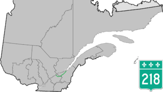
Route 218 is a two-lane east/west highway in Quebec, Canada. Its western terminus is at the junction of Route 132 in Saint-Pierre-les-Becquets and its eastern terminus is in Saint-Michel-de-Bellechasse at the junction of Route 281.

Route 276 is a 42 km two-lane east/west highway on the south shore of the Saint Lawrence River in the Chaudière-Appalaches region of Quebec, Canada. Its eastern terminus is close to Lac-Etchemin at the junction of Route 277, and the western terminus is at the junction of Route 112 in Saint-Frédéric.

Route 170 is a major east/west highway on the north shore of the St. Lawrence River in Quebec, Canada, and it parallels the Saguenay River on the south side of it. The western terminus of Route 170 is in Métabetchouan–Lac-à-la-Croix at the junction of Route 169, at Lac Saint-Jean, and the eastern terminus is in Saint-Siméon, at the junction of Route 138, close to the Saint Lawrence River.
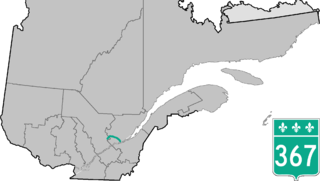
Route 367 is a 100 km two-lane north–south highway on the north shore of the Saint Lawrence River in Quebec, Canada. Although it is technically a north–south highway, long stretches of the road are east–west. Its northern/western terminus is close to Lac-aux-Sables at the junction of Route 363 and the southern/eastern terminus is in Saint-Augustin-de-Desmaures at the junction of Route 138. Route 367 used to end in Rivière-à-Pierre, but in the late 1990s, the stretch between Rivière-à-Pierre and the junction of Route 363 was added.

Area codes 418, 581, and 367 are telephone area codes in the North American Numbering Plan (NANP) for the eastern portion of the Canadian province of Quebec. Area code 418 was originally assigned to the numbering plan area, but all three area codes now form an overlay plan for this territory. Cities in the numbering plan area include Quebec City, Saguenay, Lévis, Rimouski, Saint-Georges, Alma, Thetford Mines, Sept-Îles, Baie-Comeau and Rivière-du-Loup. Also served are the Gaspé Peninsula, Côte-Nord, southeastern Mauricie, and the tiny hamlet of Estcourt Station, in the U.S. state of Maine.

The Pozer River is a river that originates in Shenley Township and flows into the Chaudière River at Saint-Georges. The latter flows northward to empty onto the south shore of the St. Lawrence River. It flows in the municipalities of Saint-Honoré-de-Shenley, Saint-Benoit-Labre and Saint-Georges, in the Beauce-Sartigan Regional County Municipality, in the administrative region of Chaudière-Appalaches, in Quebec, in Canada.

The Shenley River is a tributary of the west bank of the Chaudière River at Saint-Martin which flows northward to empty on the shore south of the St. Lawrence River. It flows in the municipalities of Saint-Honoré-de-Shenley and Saint-Martin, in the Beauce-Sartigan Regional County Municipality, in the administrative region of Chaudière-Appalaches, in Quebec, in Canada.

The rivière de la Grande Coudée is a tributary of the west bank of the Chaudière River which flows northward to empty onto the south bank of the St. Lawrence River. It flows in the municipalities of Saint-Hilaire-de-Dorset, Saint-Gédéon-de-Beauce and Saint-Martin, in the Beauce-Sartigan Regional County Municipality, in the administrative region of Chaudière-Appalaches, in Quebec, in Canada.