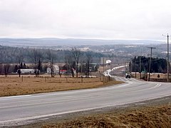
Route 173 (Route-du-Président-Kennedy) is a major north/south highway on the south shore of the St. Lawrence River in Quebec, Canada, named after the assassinated American president, John F. Kennedy. Its southern terminus is at the Armstrong-Jackman Border Crossing in Saint-Théophile in the hamlet of Armstrong, at the border with Maine, and its northern terminus is in Lévis at the junction of Route 132. Route 173 follows the Chaudière River for most of its course, from Saint-Georges, down to Scott, where the route takes a more northeastern route towards Lévis, crossing the Etchemin River in the municipality of Saint-Henri-de-Lévis.

Route 243 is a north/south highway on the south shore of the Saint Lawrence River. Its northern terminus is in Saint-Félix-de-Kingsey at the junction of Route 255 and its southern terminus is in the township of Potton where it crosses the Canada–US border at the North Troy–Highwater Border Crossing into Vermont and becomes Vermont Route 243. Route 243 is not a busy highway as it does not go through big towns.

Route 289 is a two-lane north/south highway on the south shore of the Saint Lawrence River in the Bas-Saint-Laurent region of eastern Quebec, Canada. Its northern terminus is in Saint-André-de-Kamouraska at the junction of Route 132 and the southern terminus is at the border of New Brunswick where it continues as Route 120.
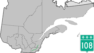
Route 108 is a two-lane east/west highway on the south shore of the Saint Lawrence River in the Eastern Townships and Chaudière-Appalaches regions of Quebec, Canada. Its eastern terminus is in Beauceville at the junction of Route 173, and the western terminus is at the junction of Route 112 in Magog.

Route 112 is a busy east–west highway on the south shore of the Saint Lawrence River in Quebec, Canada. Its eastern terminus is in Frampton at the junction of Route 275, and the western terminus is in Downtown Montreal, after crossing the Victoria Bridge. The stretch between Vallée-Jonction and Sherbrooke is a very busy highway as it is the main link between the southern regions of Quebec, in particular the Beauce region and the Eastern Townships. Between Sherbrooke and Marieville there is less traffic, since Autoroute 10 is in close proximity to the highway. From Marieville to Montreal it is a very busy highway, in most parts a four-lane separated highway, upgraded to freeway standards in certain places.
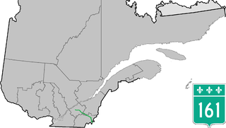
Route 161 is a north/south highway south of the St. Lawrence River in Quebec, Canada. Its current northern terminus is at Autoroute 20 in Sainte-Eulalie, just east of the junction of Autoroute 55, while its southern terminus is at the border of Maine in the USA, where it continues as Maine State Route 27. Previously the highway continued to Route 155 in Saint-Célestin, but that section was decommissioned in 2006 when Autoroute 55 was completed.

Route 143 is a north/south highway on the south shore of the Saint Lawrence River. Until the mid-1970s when the province decided to renumber all highways other than autoroutes, it was known as Route/Highway 5. Its northern terminus is in Saint-François-du-Lac, at the junction of Route 132, and the southern terminus is in Stanstead, at the border with Vermont where the road continues past the Derby Line–Stanstead Border Crossing as U.S. Route 5 through Derby Line to New Haven, Connecticut.

Route 139 is a north/south highway on the south shore of the Saint Lawrence River. Its northern terminus is in Saint-Nicéphore, now part of Drummondville, at the junction of Route 143, and the southern terminus is in Abercorn at the border with Richford, Vermont at the Richford–Abercorn Border Crossing.

Route 141 is a north/south highway in Quebec on the south shore of the Saint Lawrence River. Its northern terminus is in Magog at the junction of Route 112 and Autoroute 10, and the southern terminus is in Saint-Herménégilde at the United States border in Canaan, Vermont.

Route 133 is a historic and heritage road of the Estrie and Montérégie regions in the province of Quebec, with north/south orientation and located on the eastern shore of the Richelieu River. Its northern terminus is in Sorel-Tracy, on the south shore of the Saint Lawrence River. The southern terminus is in Saint-Armand at the United States border with Vermont, close to Highgate Springs, where it continues southward past the Highgate Springs–St. Armand/Philipsburg Border Crossing as Interstate 89. Prior to the 1970s, the portion between the international border and Saint-Jean-sur-Richelieu was known as Route 7, which served as a continuation of US 7.

Route 255 is a north–south highway on the south shore of the St. Lawrence River. Its northern terminus is in Baie-du-Febvre at the junction of Route 132 and its southern terminus is in Bury at the junction of Quebec Route 214.

Route 237 is a short 15 km north/south provincial highway on the south shore of the Saint Lawrence River in Quebec. Its northern terminus is in Stanbridge East at the junction of Route 202 and its southern terminus is in Frelighsburg, where it crosses the US border and continues past the West Berkshire–Frelighsburg Border Crossing into Vermont as Route 108.

Route 202 is an east/west 140-kilometre highway in the Monteregie and Estrie regions of the province of Quebec, Canada. Its western terminus is at the junction of Route 132 in Sainte-Barbe and its eastern terminus is in southern Cowansville at the junctions of Route 104 and Route 139. The highway runs a few kilometres north of the Canada–United States border for most of its length.

Route 247 is a north/south highway on the south shore of the Saint Lawrence River in the Estrie region of Quebec. Its northern terminus is in Magog at the junction of Route 112 and its southern terminus is in Stanstead, at the junction of Autoroute 55 less than 1 kilometre north of the Canada–United States border.

Route 212 is a two-lane east/west highway in the Estrie region in the province of Quebec, Canada. It begins in the city of Cookshire at a junction with Route 108 and runs through Newport, La Patrie and Notre-Dame-des-Bois before reaching its terminal at Route 161 in the village of Woburn.

Route 257 is a north–south highway on the south shore of the St. Lawrence River, in the Eastern Townships region of Quebec, Canada. Its northern terminus is in Saint-Adrien at a junction with Route 216, and its southern terminus is at the Pittsburg–Chartierville Border Crossing, where it becomes U.S. Route 3 as it enters Pittsburg, New Hampshire.

Route 251 is a north/south highway on the south shore of the St. Lawrence River. Its northern terminus is at Route 108 in Cookshire-Eaton, and its southern terminus is at Route 141, in Saint-Herménégilde.
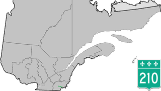
Route 210 is a provincial highway located in the Estrie region of Quebec. The 40.9 km (25.4 mi) highway runs from west to east from the Eaton area of Cookshire-Eaton at the junction of Route 108 to Chartierville at the junction of Route 257, via the village of Sawyerville. Between Eaton and Sawyerville, it overlaps Route 253 for slightly more than 4 km (2.5 mi).

Route 219 is a provincial highway located in the Montérégie region of Quebec south of Montreal. It starts at the Mooers-Hemmingford Border Crossing south of Hemmingford and ends in Saint-Jean-sur-Richelieu.

The Eaton River is a tributary of the Saint-François River which is a sub-tributary of the Saint Lawrence River. The Eaton River successively crosses the municipalities of Saint-Isidore-d'Auckland, Newport, Sawyerville, Cookshire-Eaton and East Angus. These municipalities are located in the Le Haut-Saint-François Regional County Municipality (MRC), in the administrative region of Estrie, in the south of Quebec, in Canada.