
Stanstead is a town in the Memphrémagog Regional County Municipality in the Estrie region of Quebec, located on the Canada–United States border across from Derby Line, Vermont.

Route 243 is a north/south highway on the south shore of the Saint Lawrence River. Its northern terminus is in Saint-Félix-de-Kingsey at the junction of Route 255 and its southern terminus is in the township of Potton where it crosses the Canada–US border at the North Troy-Highwater Border Crossing into Vermont and becomes Vermont Route 243. Route 243 is not a busy highway as it does not go through big towns.

Route 289 is a two-lane north/south highway on the south shore of the Saint Lawrence River in the Bas-Saint-Laurent region of eastern Quebec, Canada. Its northern terminus is in Saint-André at the junction of Route 132 and the southern terminus is at the border of New Brunswick where it continues as Route 120.
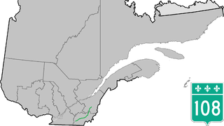
Route 108 is a two-lane east/west highway on the south shore of the Saint Lawrence River in the Eastern Townships and Chaudière-Appalaches regions of Quebec, Canada. Its eastern terminus is in Beauceville at the junction of Route 173, and the western terminus is at the junction of Route 112 in Magog.

Route 112 is a busy east/west highway on the south shore of the Saint Lawrence River in Quebec, Canada. Its eastern terminus is in Frampton at the junction of Route 275, and the western terminus is in Downtown Montreal, after crossing the Victoria Bridge. The stretch between Vallée-Jonction and Sherbrooke is a very busy highway as it is the main link between the southern regions of Quebec, in particular the Beauce region and the Eastern Townships. Between Sherbrooke and Marieville there is less traffic, since Autoroute 10 is in close proximity to the highway. From Marieville to Montreal it is a very busy highway, in most parts a four-lane separated highway, upgraded to freeway standards in certain places.

Route 147 (QC 147) is a 41.5-kilometre (25.8 mi) long north–south highway that runs from the Vermont/United States border in the town of Stanhope. The route begins at the Norton-Stanhope Border Crossing in Stanhope. The route runs north through the Coaticook Regional County Municipality, crossing through Coaticook, Compton and Waterville before reaching a junction with QC 108 and QC 143 in Waterville, which marks the northern terminus of QC 147.

Route 143 is a north/south highway on the south shore of the Saint Lawrence River. Until the mid-1970s when the province decided to renumber all highways other than autoroutes, it was known as Route/Highway 5. Its northern terminus is in Saint-François-du-Lac, at the junction of Route 132, and the southern terminus is in Stanstead at the border with Vermont where the road continues past the Derby Line-Stanstead Border Crossing as U.S. Route 5 through Derby Line to New Haven, Connecticut.
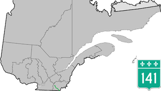
Route 141 is a north/south highway in Quebec on the south shore of the Saint Lawrence River. Its northern terminus is in Magog at the junction of Route 112 and Autoroute 10, and the southern terminus is in Saint-Herménégilde at the United States border in Canaan, Vermont.

Route 237 is a short 15 km north/south provincial highway on the south shore of the Saint Lawrence River in Quebec. Its northern terminus is in Stanbridge East at the junction of Route 202 and its southern terminus is in Frelighsburg, where it crosses the US border and continues past the West Berkshire–Frelighsburg Border Crossing into Vermont as Route 108.

Route 202 is an east/west 140-kilometer highway in the Monteregie region of the province of Quebec, Canada. Its western terminus is at the junction of Route 132 in Sainte-Barbe and its eastern terminus is in southern Cowansville at the junctions of Route 104 and Route 139. The highway runs a few kilometers north of the United States-Canada border for most of its length.

Route 249 is a two-lane north/south highway on the south shore of the Saint Lawrence River in Quebec, Canada. Its northern terminus is in Asbestos at the junction of Route 255, and the southern terminus is at the junction of Route 112 close to Magog.
Provincial Trunk Highway 5 is a provincial primary highway located in the Canadian province of Manitoba.

Route 257 is a north-south highway on the south shore of the St. Lawrence River, in the Eastern Townships region of Quebec, Canada. Its northern terminus is in Saint-Adrien at a junction with Route 216, and its southern terminus is the Pittsburg-Chartierville Border Crossing in New Hampshire, after which it becomes US 3.

The Tomifobia River is a flowing body of fresh water in Memphremagog Regional County Municipality, in the Eastern Townships, in the province of Quebec, in Canada. The river forms a part of an international border between Canada and the United States near the village of Beebe Plain, Vermont.

The Beebe Plain-Beebe Border Crossing is a border crossing station on the Canada–United States border. It connects Rue Principale in Beebe Plain, Québec with Beebe Road in Beebe Plain, a village in Derby, Vermont. Both the US and Canadian station buildings are historical properties listed by their respective governments.
The Massawippi Valley Railway was a short line railway established 1870 between Lennoxville, Quebec, and the Vermont border. Part of the Quebec Central Railway from 1926, the line was abandoned in 1990 and removed in 1992. Most of the former railway's path is now bicycle trails.
Johns River is a tributary of the Lake Memphremagog, flowing in the municipality of Derby in northern Vermont, in United States and in the municipality of Stanstead (city), Quebec in the Memphremagog Regional County Municipality (RCM), in the administrative region of Estrie, south of Quebec, in Canada.


