Missisquoi County is a historical county in Quebec. It was formed between 1825 and 1831 and included historical Bedford County, Lower Canada. In the early 1980s Quebec abolished its counties. Much of Missisquoi County became the Brome-Missisquoi Regional County Municipality except the southwestern part was transferred to Le Haut-Richelieu Regional County Municipality.
Missisquoi was a federal electoral district in Quebec, Canada, that was represented in the House of Commons of Canada from 1867 to 1925.

Route 299 is a 137-kilometre (85 mi) long two-lane highway which cuts through the Appalachian Mountains in Quebec, Canada. It starts at the junction of Route 132 in Cascapédia–Saint-Jules, runs through Gaspésie National Park and ends at the junction of Route 132 in Sainte-Anne-des-Monts. It is an isolated highway with only a few small settlements along the way.

Route 104 is an east/west highway on the south shore of the St. Lawrence River. Its eastern terminus is in Knowlton at the junction of Route 243 and its western terminus is in La Prairie at the junction of Route 134.

Route 232 is a two-lane east/west provincial highway on the south shore of the St. Lawrence River in the Bas-Saint-Laurent region of Eastern Quebec, Canada. Its eastern terminus is in Rimouski at the junction of Route 132 and the western terminus is at the junction of Route 289 in Rivière-Bleue. The route temporarily becomes A-85 along a 3 kilometre section through Cabano.
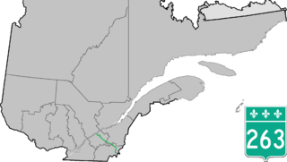
Route 263 is a two-lane north/south highway on the south shore of the Saint Lawrence River in Quebec, Canada. Its northern terminus is in the city of Bécancour at the junction of Route 132, and the southern terminus is at the junction of Route 161 close to Saint-Augustin-de-Woburn.

Route 265 is a two-lane north/south highway on the south shore of the Saint Lawrence River in Quebec, Canada. Its northern terminus is in Deschaillons-sur-Saint-Laurent at the junction of Route 132, and the southern terminus is at the junction of Route 165 in Plessisville. It used to continue up to Black Lake at the junction of Route 112, but the segment between Plessisville and Black Lake was later re-numbered to Route 165 in the 1990s.
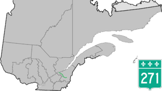
Route 271 is a two-lane north/south highway on the south shore of the Saint Lawrence River in Quebec, Canada. Its northern terminus is in Sainte-Croix at the junction of Route 132, and the southern terminus is at the junction of Route 173 in Saint-Georges.

Route 226 is a two-lane east/west highway in Quebec, Canada. Its western terminus is at the junction of Route 132 in Pierreville and its eastern terminus is in Sainte-Croix at the junction of Route 271.

Route 259 is a north–south highway on the south shore of the St. Lawrence River in Quebec, Canada. Its northern terminus is in Nicolet at the junction of Route 132 and its southern terminus is in Notre-Dame-du-Bon-Conseil at the junction of Route 122.

Route 237 is a short 15 km north/south provincial highway on the south shore of the Saint Lawrence River in Quebec. Its northern terminus is in Stanbridge East at the junction of Route 202 and its southern terminus is in Frelighsburg, where it crosses the US border and continues past the West Berkshire–Frelighsburg Border Crossing into Vermont as Route 108.

Route 223 is a 128.6 km north/south highway on the south shore of the Richelieu River in Quebec. Its northern terminus is in Sorel-Tracy at the junction of Route 132 and its southern terminus is close to Lacolle, where it crosses the U.S. border at the Rouses Point–Lacolle 223 Border Crossing and continues into New York state as U.S. Route 11.

Route 236 is a two-lane east/west highway on the south shore of the Saint Lawrence River in the Montérégie region of Quebec, Canada. Its western terminus is in Saint-Stanislas-de-Kostka at the junction of Route 132 and the eastern terminus is at the junction of Route 132 again, in Beauharnois.

Route 205 is a two-lane north/south highway on the south shore of the Saint Lawrence River in the Montérégie region of Quebec, Canada. Its northern terminus is in Beauharnois at the junction of Route 132 and the southern terminus is at the junction of Route 219, in Hemmingford Township.

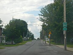
Route 201 is a north/south provincial highway within the Canadian province of Quebec, running between Route 202 in Franklin and Route 342 in Rigaud. Its total length is approximately 70 kilometres.

Hemmingford is a township municipality in south-west Quebec, founded in 1799. The population as of the Canada 2011 Census was 1,747. The township completely surrounds the Village of Hemmingford. The two entities are locally referred to collectively as Hemmingford. The two share many things, such as the cost of the volunteer fire department, and both hold their councils and offices in the same building in the village.

The Diocese of Montreal is a diocese of the Ecclesiastical Province of Canada of the Anglican Church of Canada, in turn a province of the Anglican Communion. The diocese comprises the 21,400 square kilometres (8,300 sq mi) encompassing the City and Island of Montreal, the Laurentians, the South Shore opposite Montreal, and part of the Eastern Townships. The See city is Montreal, and the cathedral is Christ Church. The diocese maintains approximately 9,000 on its parish rolls in about seventy parishes.
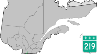
Route 219 is a provincial highway located in the Montérégie region of Quebec south of Montreal. It starts at the Mooers-Hemmingford Border Crossing south of Hemmingford and ends in Saint-Jean-sur-Richelieu.

Route 225 is a provincial highway located in the Montérégie region of Quebec. The route starts at the Canada-United States border at the Alburgh–Noyan Border Crossing in Noyan and runs north along the eastern shores of the Richelieu River, ending in Sainte-Anne-de-Sabrevois at the junction of Route 133.
The Lacolle River flows in the municipality of Lacolle, Quebec, in Le Haut-Richelieu Regional County Municipality, Montérégie, on the south shore of St. Lawrence River in Quebec in Canada. The economy of the watershed is primarily agricultural and recreation and tourism including the popular Safari park of Hemmingford which began operating in 1972, the country club golf course and three ciders.