Lotbinière was a federal electoral district in Quebec, Canada, that was represented in the House of Commons of Canada from 1867 to 2004.

Route 173 (Route-du-Président-Kennedy) is a major north/south highway on the south shore of the St. Lawrence River in Quebec, Canada, named after the assassinated American president, John F. Kennedy. Its southern terminus is at the Armstrong-Jackman Border Crossing in Saint-Théophile in the hamlet of Armstrong, at the border with Maine, and its northern terminus is in Lévis at the junction of Route 132. Route 173 follows the Chaudière River for most of its course, from Saint-Georges, up to Scott, where the route takes a more northeastern route towards Lévis, crossing the Etchemin River in the municipality of Saint-Henri-de-Lévis.

Route 216 is a two-lane east/west highway in Quebec, Canada, which starts in Sainte-Catherine-de-Hatley in the Estrie region at the junction of Route 108 and ends in Sainte-Perpétue in Chaudière-Appalaches at the junction of Route 204.

Route 263 is a two-lane north/south highway on the south shore of the Saint Lawrence River in Quebec, Canada. Its northern terminus is in the community of Gentilly, part of Bécancour at the junction of Route 132, and the southern terminus is at the junction of Route 161 close to Saint-Augustin-de-Woburn.

Route 265 is a two-lane north/south highway on the south shore of the Saint Lawrence River in Quebec, Canada. Its northern terminus is in Deschaillons at the junction of Route 132, and the southern terminus is at the junction of Route 165 in Plessisville. It used to continue up to Black Lake at the junction of Route 112, but the segment between Plessisville and Black Lake was later re-numbered to Route 165 in the 1990s.

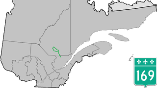
Route 271 is a two-lane north/south highway on the south shore of the Saint Lawrence River in Quebec, Canada. Its northern terminus is in Sainte-Croix at the junction of Route 132, and the southern terminus is at the junction of Route 173 in Saint-Georges.
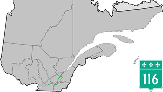
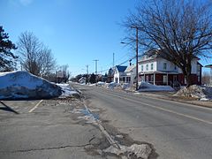
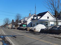
Route 116 is an east/west highway on the south shore of the Saint Lawrence River in Quebec, Canada. Until the mid-1970s it was known as Route 9. Its eastern terminus is in Lévis at the junction of Route 132, and the western terminus is at the junction of Route 134 in Lemoyne part of a concurrency with Route 112 until Saint-Hubert just south of the Saint-Hubert Municipal Airport. The stretch between Lévis and Plessisville does not have much traffic, since Autoroute 20 is not that far from the highway. Between Plessisville and Richmond traffic is heavier as it passes bigger towns, and it is further away from Autoroute 20. From Richmond to Autoroute 20, it is quiet again, before reaching Saint-Hyacinthe, where it becomes a busy four-lane separated highway, going through the growing "South Shore" suburbs of Montreal. From the junction of Autoroute 30 to its western terminus, it is a controlled-access Autoroute-grade expressway. This portion was once envisioned to be part of Autoroute 16. An unofficial extension of Route 116 as thought of by locals, from the western terminus follows the Route 134 limited access expressway to the Jacques Cartier Bridge.

Route 165 is a 68 km north/south highway on the south shore of the Saint Lawrence River in Quebec, Canada. Its southern terminus is in Black Lake, now part of Thetford Mines, at the junction of Route 112 and its northern terminus is in Saint-Louis-de-Blandford at the junction of Autoroute 20. The stretch between Plessisville and Black Lake used to be Route 265 but it was re-numbered Route 165 in the 1990s.

Provincial Highway 159 is a two-lane north/south highway on the north shore of the Saint Lawrence River in Quebec, Canada. Its northern terminus is in Saint-Roch-de-Mékinac at the junction of Route 155, and the southern terminus is at the junction of Route 138 in Sainte-Anne-de-la-Pérade.

Route 122 is an east/west highway on the south shore of the Saint Lawrence River in Quebec, Canada. Its western terminus is at the junction of Route 132 in Yamaska and the eastern terminus is in Victoriaville at the junction of Route 116. The highway acts mainly as the main link between Drummondville and Sorel-Tracy, and somewhat as a major link between Victoriaville and Drummondville.

Route 275 is a two-lane north/south highway in the Chaudière-Appalaches region in the province of Quebec. Its northern terminus is in Saint-Romuald, now part of Lévis at the junction of Route 132 and its southern terminus is in Saint-Côme–Linière at the junction of Route 173.

Route 277 is a two-lane north/south highway in the Chaudière-Appalaches region in the province of Quebec, Canada. Its northern terminus is in Saint-Henri at the junction of Route 173 and its southern terminus is in Sainte-Aurélie at the junction of Route 275.
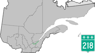
Route 218 is a two-lane east/west highway in Quebec, Canada. Its western terminus is at the junction of Route 132 in Saint-Pierre-les-Becquets and its eastern terminus is in Saint-Michel-de-Bellechasse at the junction of Route 281.

Route 255 is a north/south highway on the south shore of the St. Lawrence River. Its northern terminus is in Baie-du-Febvre at the junction of Route 132 and its southern terminus is in Bury at the junction of Quebec Route 214.

Route 259 is a north/south highway on the south shore of the St. Lawrence River in Quebec, Canada. Its northern terminus is in Nicolet at the junction of Route 132 and its southern terminus is in Notre-Dame-du-Bon-Conseil at the junction of Route 122.

Route 202 is an east/west 140-kilometer highway in the Monteregie region of the province of Quebec, Canada. Its western terminus is at the junction of Route 132 in Sainte-Barbe and its eastern terminus is in southern Cowansville at the junctions of Route 104 and Route 139. The highway runs a few kilometers north of the United States-Canada border for most of its length.
Route 169 begins south of Lac Saint-Jean, Quebec, Canada, at Route 175. It proceeds north to Lac Saint-Jean at Alma and encircles the lake, returning to Alma and its terminus in Hebertville.

Route 239 is a north/south highway on the south shore of the Saint Lawrence River. Its northern terminus is at Route 133 in Sainte-Victoire-de-Sorel and its southern terminus is at Saint-Germain-de-Grantham at the junction of Route 122.
Lotbinière is a former provincial electoral district in the Centre-du-Québec and Chaudière-Appalaches regions of Quebec, Canada. As of its final election, it included the municipalities of Lotbinière, Saint-Flavien, Lemieux, Laurierville, Saint-Antoine-de-Tilly, Sainte-Croix and Laurier-Station.

Route 350 is a provincial highway located in the Mauricie region of Quebec. It runs from the junction of Route 348 in Saint-Édouard-de-Maskinongé to the junction of Route 153 west of Saint-Boniface-de-Shawinigan. It overlaps Route 349 in Saint-Paulin and Route 351 in Charette.