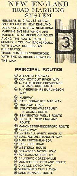
The New England road marking system was a regional system of marked numbered routes in the six-state region of New England in the United States. The routes were marked by a yellow rectangular sign with black numbers and border. Many signs were painted on telephone poles. The routes were approved by the highway departments of the six New England states in April 1922.

Route 138 is a major highway in the Canadian province of Quebec, following the entire north shore of the Saint Lawrence River past Montreal to the temporary eastern terminus in Kegashka on the Gulf of Saint Lawrence. The western terminus is in Elgin, at the border with New York State south-west of Montreal. Part of this highway is known as the Chemin du Roy, or King's Highway, which is one of the oldest highways in Canada.

Vermont Route 105 (VT 105) is a 98.135-mile-long (157.933 km) state highway located in northern Vermont in the United States. The route runs from U.S. Route 7 (US 7) in St. Albans in the west to the New Hampshire state line in Bloomfield in the east. The road continues across the state line as Bridge Street, a short unnumbered New Hampshire state route to US 3 in North Stratford, New Hampshire. As it is not a New Hampshire state highway, the connection is signed with Vermont state highway signage, similar to how connections to Vermont state routes are indicated elsewhere in New Hampshire.

Route 213 is a short two-lane north/south highway in the province of Quebec, Canada, which starts in Frelighsburg at the junction of Route 237 and ends in Dunham at the junction of Route 202. It is the shortest road in Quebec that is provincially signed.

Route 243 is a north/south highway on the south shore of the Saint Lawrence River. Its northern terminus is in Saint-Félix-de-Kingsey at the junction of Route 255 and its southern terminus is in the township of Potton where it crosses the Canada–US border at the North Troy–Highwater Border Crossing into Vermont and becomes Vermont Route 243. Route 243 is not a busy highway as it does not go through big towns.
Route 147 (QC 147) is a 41.5-kilometre-long (25.8 mi) north–south highway that runs from the Vermont/United States border in the town of Stanhope. The route begins at the Norton–Stanhope Border Crossing in Stanhope. The route runs north through the Coaticook Regional County Municipality, crossing through Coaticook, Compton and Waterville before reaching a junction with QC 108 and QC 143 in Waterville, which marks the northern terminus of QC 147.

Route 143 is a north/south highway on the south shore of the Saint Lawrence River. Until the mid-1970s when the province decided to renumber all highways other than autoroutes, it was known as Route/Highway 5. Its northern terminus is in Saint-François-du-Lac, at the junction of Route 132, and the southern terminus is in Stanstead, at the border with Vermont where the road continues past the Derby Line–Stanstead Border Crossing as U.S. Route 5 through Derby Line to New Haven, Connecticut.
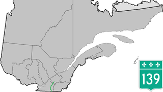
Route 139 is a north/south highway on the south shore of the Saint Lawrence River. Its northern terminus is in Saint-Nicéphore, now part of Drummondville, at the junction of Route 143, and the southern terminus is in Abercorn at the border with Richford, Vermont at the Richford–Abercorn Border Crossing.
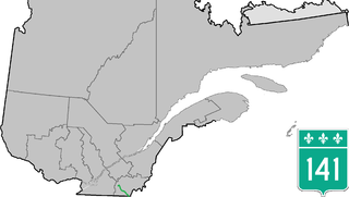
Route 141 is a north/south highway in Quebec on the south shore of the Saint Lawrence River. Its northern terminus is in Magog at the junction of Route 112 and Autoroute 10, and the southern terminus is in Saint-Herménégilde at the United States border in Canaan, Vermont.

Route 133 is a historic and heritage road of the Estrie and Montérégie regions in the province of Quebec, with north/south orientation and located on the eastern shore of the Richelieu River. Its northern terminus is in Sorel-Tracy, on the south shore of the Saint Lawrence River. The southern terminus is in Saint-Armand at the United States border with Vermont, close to Highgate Springs, where it continues southward past the Highgate Springs–St. Armand/Philipsburg Border Crossing as Interstate 89. Prior to the 1970s, the portion between the international border and Saint-Jean-sur-Richelieu was known as Route 7, which served as a continuation of US 7.

Route 202 is an east/west 140-kilometre highway in the Monteregie and Estrie regions of the province of Quebec, Canada. Its western terminus is at the junction of Route 132 in Sainte-Barbe and its eastern terminus is in southern Cowansville at the junctions of Route 104 and Route 139. The highway runs a few kilometres north of the Canada–United States border for most of its length.

Route 223 is a 128.6 km north/south highway on the south shore of the Richelieu River in Quebec. Its northern terminus is in Sorel-Tracy at the junction of Route 132 and its southern terminus is close to Lacolle, where it crosses the U.S. border at the Rouses Point–Lacolle 223 Border Crossing and continues into New York state as U.S. Route 11.

Route 247 is a north/south highway on the south shore of the Saint Lawrence River in the Estrie region of Quebec. Its northern terminus is in Magog at the junction of Route 112 and its southern terminus is in Stanstead, at the junction of Autoroute 55 less than 1 kilometre north of the Canada–United States border.
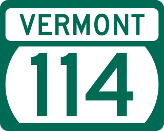
Vermont Route 114 (VT 114) is a 53.094-mile-long (85.447 km) north–south state highway in northeastern Vermont in the United States. It runs northward from U.S. Route 5 (US 5) in Lyndon until nearing the Canada–United States border in the town of Norton; thereafter, the road continues east to the New Hampshire state line in Canaan. The vast majority of VT 114 is situated within Essex County; however, the route also passes through small, isolated portions of Caledonia and Orleans Counties.
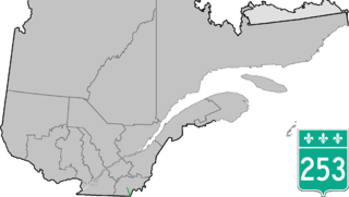
Route 253 is a north–south highway on the south shore of the St. Lawrence River. Its northern terminus is in East Angus at Route 112 and its southern terminus is at the Vermont border, where it becomes Vermont Route 253.
Frelighsburg is a municipality in the Estrie region of southern Quebec, Canada, on the border with Vermont. It is at the foot of Mount Pinnacle, part of the Appalachian Mountains.

Vermont Route 108 (VT 108) is a north–south state highway in northern Vermont, United States. Its southern terminus is at VT 100 in Stowe, and its northern terminus is at the Canada–US border in Franklin, where it continues into Quebec past the West Berkshire–Frelighsburg Border Crossing as Route 237. VT 108 is 45.450 miles (73.145 km) long.

U.S. Route 5 (US 5) is a part of the United States Numbered Highway System that runs from New Haven, Connecticut, to the Canada–United States border at Derby Line, Vermont. In Vermont, the road runs south–north from the Massachusetts state line near Guilford to the international border. The 192.317 miles (309.504 km) that lie in Vermont are maintained by the Vermont Agency of Transportation (VTrans) and run largely parallel to Interstate 91 (I-91). US 5 also follows the path of the Connecticut River from the Massachusetts border to St. Johnsbury, where the river turns northeast while US 5 continues north. The highway serves the major towns of Brattleboro, Hartford, and St. Johnsbury, along with the city of Newport near the Canadian border.

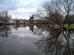
Pike River is a tributary of lake Champlain, flowing successively in:
The West Berkshire–Frelighsburg Border Crossing connects the town of Frelighsburg, Quebec with the western portion of Berkshire, Vermont on the Canada–United States border. It is reached by Vermont Route 108 on the American side and by Quebec Route 237 on the Canadian side.