
Les Chenaux is a regional county municipality in central Quebec, Canada, in the Mauricie region. The seat is in Saint-Luc-de-Vincennes. It is located adjacent on the east of Trois-Rivières on the Saint Lawrence River. It has a land area of 872.04 square kilometres (336.70 sq mi) and a population of 17,865 inhabitants in the Canada 2011 Census. Its largest community is the parish of Notre-Dame-du-Mont-Carmel.

Autoroute 20 is a Quebec Autoroute, following the Saint Lawrence River through one of the more densely populated parts of Canada, with its central section forming the main route of the Trans-Canada Highway from the A-25 interchange to the A-85 interchange. At 585 km (363.5 mi), it is the longest Autoroute in Quebec. It is one of two main links between Montreal and Quebec City; the other is the A-40.

Route 281 is a 75 km two-lane north/south highway in the Chaudière-Appalaches region in the province of Quebec, Canada. Its northern terminus is in St-Michel at the junction of Route 132 and its southern terminus is close to Saint-Camille-de-Lellis at the junction of Route 204.

Route 104 is an east/west highway on the south shore of the St. Lawrence River. Its eastern terminus is in Knowlton at the junction of Route 243 and its western terminus is in La Prairie at the junction of Route 134.

Route 232 is a two-lane east/west provincial highway on the south shore of the St. Lawrence River in the Bas-Saint-Laurent region of Eastern Quebec, Canada. Its eastern terminus is in Rimouski at the junction of Route 132 and the western terminus is at the junction of Route 289 in Rivière-Bleue. The route temporarily becomes A-85 along a 3 kilometre section through Cabano.
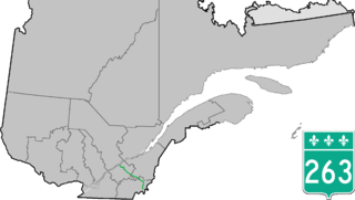
Route 263 is a two-lane north/south highway on the south shore of the Saint Lawrence River in Quebec, Canada. Its northern terminus is in the community of Gentilly, part of Bécancour at the junction of Route 132, and the southern terminus is at the junction of Route 161 close to Saint-Augustin-de-Woburn.
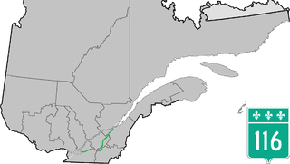
Route 116 is an east/west highway on the south shore of the Saint Lawrence River in Quebec, Canada. Until the mid-1970s it was known as Route 9. Its eastern terminus is in Lévis at the junction of Route 132, and the western terminus is at the junction of Route 134 in Lemoyne part of a concurrency with Route 112 until Saint-Hubert just south of the Saint-Hubert Municipal Airport. The stretch between Lévis and Plessisville does not have much traffic, since Autoroute 20 is not that far from the highway. Between Plessisville and Richmond traffic is heavier as it passes bigger towns, and it is further away from Autoroute 20. From Richmond to Autoroute 20, it is quiet again, before reaching Saint-Hyacinthe, where it becomes a busy four-lane separated highway, going through the growing "South Shore" suburbs of Montreal. From the junction of Autoroute 30 to its western terminus, it is a controlled-access Autoroute-grade expressway. This portion was once envisioned to be part of Autoroute 16. An unofficial extension of Route 116 as thought of by locals, from the western terminus follows the Route 134 limited access expressway to the Jacques Cartier Bridge.

Route 157 is a four-lane north–south highway on the north shore of the Saint Lawrence River in Quebec, Canada. Its northern terminus is in Shawinigan at the junction of Route 153, and the southern terminus is at the junction of Route 138 in Cap-de-la-Madeleine, now part of Trois-Rivières.

Route 137 is a north/south highway on the south shore of the Saint Lawrence River in Quebec, Canada. Its northern terminus is in Saint-Denis-sur-Richelieu, at the junction of Route 133, and the southern terminus is in Granby at the junction of Route 112.

Route 133 is a historic and heritage road of the Montérégie region in the province of Quebec, with north/south orientation and located on the eastern shore of the Richelieu River. Its northern terminus is in Sorel-Tracy, on the south shore of the Saint Lawrence River. The southern terminus is in Saint-Armand at the United States border with Vermont, close to Highgate Springs, where it continues southward past the Highgate Springs–St. Armand/Philipsburg Border Crossing as Interstate 89. Prior to the 1970s, the portion between the international border and Saint-Jean-sur-Richelieu was known as Route 7, which served as a continuation of US 7.

Autoroute 85 is a Quebec Autoroute and the route of the Trans-Canada Highway in the province's Bas-Saint-Laurent region, also known as the Autoroute Claude-Béchard. It is currently under construction with committed Federal and Provincial funding for its completion, with an estimated completion date of 2025. Once this upgrade is completed, it will close the last gap in the nearly continuous freeway section of the Trans-Canada between Arnprior, Ontario, and Sutherlands River, Nova Scotia, and for an even longer interprovincial freeway route between Windsor, Ontario and Halifax, Nova Scotia. Running between Rivière-du-Loup and a junction with New Brunswick Route 2 at the Quebec-New Brunswick border, the A-85 when complete will be the only controlled access highway link between the Maritime Provinces and the rest of the country. The A-85 is projected to be approximately 100 km (60 mi) long when construction is complete and is intended to replace Route 185, which has been called one of the deadliest highways in Canada.

Route 223 is a 128.6 km north/south highway on the south shore of the Richelieu River in Quebec. Its northern terminus is in Sorel-Tracy at the junction of Route 132 and its southern terminus is close to Lacolle, where it crosses the U.S. border at the Rouses Point–Lacolle 223 Border Crossing and continues into New York state as U.S. Route 11.

Route 249 is a two-lane north/south highway on the south shore of the Saint Lawrence River in Quebec, Canada. Its northern terminus is in Val-des-Sources at the junction of Route 255, and the southern terminus is at the junction of Route 112 close to Magog.

Route 335 is a north-south route from Montreal north into the Lanaudière region of Quebec.
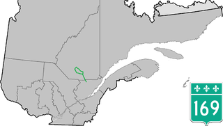
Route 169 begins south of Lac Saint-Jean, Quebec, Canada, at Route 175. It proceeds north to Lac Saint-Jean at Alma and encircles the lake, returning to Alma and its terminus in Hebertville.

Route 257 is a north–south highway on the south shore of the St. Lawrence River, in the Eastern Townships region of Quebec, Canada. Its northern terminus is in Saint-Adrien at a junction with Route 216, and its southern terminus is at the Pittsburg–Chartierville Border Crossing, where it becomes U.S. Route 3 as it enters Pittsburg, New Hampshire.

Route 366 is a secondary highway in the Outaouais region of Quebec. It runs from Route 301 near Creemorne in the Pontiac to Route 148 in the city of Gatineau.

Route 309 is a provincial highway located in the Outaouais region in western Quebec. It starts at the junction of Autoroute 50 in the Buckingham sector, in the city of Gatineau's east end. It runs mostly parallel to the Du Lièvre River and ends north of Mont-Laurier in the town of Sainte-Anne-du-Lac in the Upper Laurentians.
The Kamouraska river is a tributary of the south shore of the St. Lawrence River where it flows two km east of the center of the village of Kamouraska. This river flows in the municipalities of Saint-Gabriel-Lalemant, Mont-Carmel, Saint-Bruno-de-Kamouraska, Saint-Pascla and Kamouraska, in the Kamouraska Regional County Municipality, in the administrative region of Bas-Saint-Laurent, in province of Quebec, in Canada.

The Saint-Denis River is a tributary of the south-eastern shore of the Kamouraska River, which flows on the south shore of the St. Lawrence river two km to the east of the village center of Kamouraska.

