List of bridges to the Island of Montreal

Last updated

Bridges are required to connect Montreal to the mainland (gray). Archipel Hochelaga.PNG
Bridges are required to connect Montreal to the mainland (gray).

Like most major cities, Montreal needs easy highway access from its suburbs and surrounding areas. However, because Montreal was built on an island surrounded by three rivers, it can be entered by land only on a bridge or through a tunnel. Although the city was founded in 1642, [1] it was not until 1847 that the first fixed link to the outside was established when a wooden bridge was built across Rivière des Prairies to Île Jésus, on the site of what is now Ahuntsic Bridge. Another bridge was built immediately afterward, a few kilometers west, which became Lachapelle Bridge, and another in 1849, Pont des Saints-Anges, to the east. [2] The latter bridge collapsed in the 1880s and was never rebuilt. [2]

Contents

With the advent of the railroad, Montreal got a fixed link to the mainland; in 1854 railroad bridges were built in Sainte-Anne-de-Bellevue, across both channels of the Ottawa River, linking Montreal Island to Ontario and the Vaudreuil-Soulanges peninsula through Perrot Island. [3] In 1860, Montreal got its first link to the South Shore with the construction of Victoria Bridge, which was, at the time of its opening, the longest bridge in the world. [4] Indirect links to the North Shore also had to wait for railroad construction, but this took longer; the Canadian Pacific Railway opened its link to Saint-Jérôme in 1876, through Île Jésus. [2]

Crossings

This list of bridges and other fixed links serving the Island of Montreal proceeds counter-clockwise around the island from southwest, at the exit of Lake Saint-Louis, downstream along the St. Lawrence River, then upstream along Rivière des Prairies all the way to Lake of Two Mountains, then downstream again along the East Channel of the Ottawa River until it reaches Lake Saint-Louis. The year of construction is that of the structure currently in place, accompanied by the year of construction of the original structure if the current one replaced an older span.

Key: Communities linked by individual bridges
  (M): Montreal-side municipality and borough
  (I): Island(s) crossed, if any
  (O): Opposite-side municipality and borough

Spanning the Saint Lawrence River and Saint Lawrence Seaway

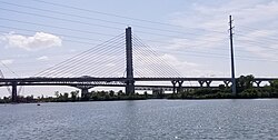
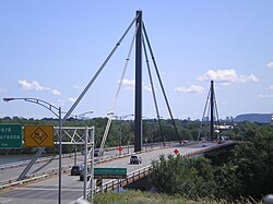
The crossing of the Saint Lawrence River has always proved problematic for engineers due to width, depth, currents, and ice cover. The construction of Victoria Bridge for the Grand Trunk Railway, which, at 2 kilometres (1.2 mi), was the longest bridge in the world when it first opened in 1860, [4] highlighted the problems presented by this natural obstacle. [5] Not to be outdone by its rival, however, the Canadian Pacific Railway built its own span, the Saint-Laurent Railway Bridge, upstream from the Lachine Rapids in 1886 [6] for which the Mohawks of Kahnawake were hired to erect the steel superstructure. [7] Although Victoria Bridge was also used as a road crossing since 1898, it was not before the 1930s that two fully dedicated road bridges, Jacques-Cartier and Mercier, were built. [8] [9] More spans, including Louis-Hippolyte Lafontaine Bridge–Tunnel and Champlain Bridge, were built in the 1960s. [10] [11] No new span was built for over 50 years, until a replacement Champlain Bridge was constructed at the cost of several billion dollars. It opened in 2019, while the previous span was closed to traffic to be demolished.

The construction of the Saint Lawrence Seaway in the 1950s required extensive modifications for all spans that existed at the time. Those are not reflected in the table below.

SpanPictureFirst span builtCurrent span builtCommunities linkedCarriesName origin Coordinates
Saint-Laurent Railway Bridge Pont Saint-Laurent (LaSalle).jpg 18861910 [6] (M) Borough of LaSalle Canadian Pacific Railway (CPR)

exo Candiac commuter train

Saint Lawrence River 45°25′8″N73°39′34″W / 45.41889°N 73.65944°W / 45.41889; -73.65944 (Saint-Laurent Railway Bridge)
(O) Kahnawake Mohawk Reserve
Honoré Mercier Bridge Mercier Bridge, Lasalle side.JPG
1934, 1963 [9] [A] (M) Borough of LaSalle Qc138.svg
Route 138
Honoré Mercier (1840–1894), Premier of Quebec 45°25′0″N73°39′18″W / 45.41667°N 73.65500°W / 45.41667; -73.65500 (Honoré Mercier Bridge)
(O) Kahnawake Mohawk Reserve
Champlain Bridge Ice Structure Champlain Bridge ice structure.JPG
1964 [12] [B] (M) Borough of Verdun Route Verte 1 and 2 Samuel de Champlain (c. 1580–1635), founder of Quebec City 45°27′57″N73°31′11″W / 45.46583°N 73.51972°W / 45.46583; -73.51972 (Champlain Bridge Ice Structure)
(O) St. Lawrence Seaway levee
Samuel De Champlain Bridge Samuel de Champlain Bridge from east.jpg 1962 [10] [C] 2019(M) Borough of VerdunQuebec Autoroute 10.svgQuebec Autoroute 15.svgQuebec Autoroute 20.svg

Autoroutes 10, 15, and 20

45°28′7″N73°31′15″W / 45.46861°N 73.52083°W / 45.46861; -73.52083 (Champlain Bridge)
(I) Île des Sœurs (exit)
(O) Brossard
Victoria Bridge Pont Victoria.JPG 18601898 [5] [D] (M) Borough of Le Sud-Ouest Qc112.svg
Route 112

Canadian National Railway (CN)

exo Mont-Saint-Hilaire commuter train

Via Rail and Amtrak passenger trains

Queen Victoria of the United Kingdom (1819–1901) 45°29′29″N73°31′46″W / 45.49139°N 73.52944°W / 45.49139; -73.52944 (Victoria Bridge)
(O) Saint-Lambert
Pont de la Concorde and Pont des Îles Pont de la Concorde.JPG
1965 [13] [E] (M) Borough of Ville-Marie Pierre-Dupuy Avenue and Route Verte 1 and 2Reference to Montreal's motto, Concordia salus [13] 45°30′22″N73°32′17″W / 45.50611°N 73.53806°W / 45.50611; -73.53806 (Pont de la Concorde)

45°30′28″N73°31′49″W / 45.50778°N 73.53028°W / 45.50778; -73.53028 (Saint-Lambert) (Pont des Îles)

(O) Île Sainte-Hélène and Île Notre-Dame (Parc Jean-Drapeau), borough of Ville-Marie, Montreal
Montreal Metro Tunnel Station-Jean-Drapeau-exterior.jpg
1966 [14] (M) Borough of Ville-Marie (Berri-UQAM station) Line 4 Yellow
45°30′N73°32′W / 45.500°N 73.533°W / 45.500; -73.533 (Metro tunnel (line 4))
(I) Île Sainte-Hélène (Jean-Drapeau station) and Île Notre-Dame
(O) Longueuil, borough of Vieux-Longueuil (Longueuil–Université-de-Sherbrooke station)
Jacques Cartier Bridge Jacques-Cartier bridge.JPG
1930 [8] [F] (M) Borough of Ville-MarieQc134.svg
Route 134

Pedestrians and bicycles

Jacques Cartier (1491–1557), French explorer 45°31′17″N73°32′28″W / 45.52139°N 73.54111°W / 45.52139; -73.54111 (Jacques Cartier Bridge)
(I) Île Sainte-Hélène (exit) and Île Notre-Dame
(O) Longueuil, borough of Vieux-Longueuil
Louis-Hippolyte Lafontaine Bridge–Tunnel Louis H Lafontaine Tunnel.JPG
1967 [11] [G] (M) Borough of Mercier–Hochelaga-Maisonneuve Quebec Autoroute 25.svgTrans-Canada Highway Quebec.svg
Autoroute 25/Trans-Canada Highway
Louis-Hippolyte Lafontaine (1807–1864), Prime Minister of the United Province of Canada 45°35′0″N73°29′51″W / 45.58333°N 73.49750°W / 45.58333; -73.49750 (Louis Hippolyte Lafontaine Tunnel)
(I) Île Charron (Îles de Boucherville) (exit)
(O) Longueuil, borough of Vieux-Longueuil

Spanning the Rivière des Prairies

Although the Rivière des Prairies is much smaller than the Saint Lawrence, bridge construction there did not begin until the 1840s—when rapid construction began on three wooden toll bridges to what is now Laval, one of which, Pont des Saints-Anges, collapsed in the 1880s and was never rebuilt. [2] The existence of regular ferry services across the river is attested from 1813, [15] but these ferries were discontinued when the bridges opened. The first railroad across the river was opened in 1876, and the Bordeaux Railway Bridge is the oldest fixed link to Laval that is still standing. (Another bridge across Rivière des Mille Îles, which was part of the same line, collapsed in 1882 but was immediately rebuilt. [2] ) The highway construction boom of the 1960s and 1970s led to the construction of four new freeway bridges across the river, and the upgrading of the existing Pie IX Bridge to freeway standards. [2]

SpanPictureFirst span builtCurrent span builtCommunities linkedCarriesName origin Coordinates
Le Gardeur Bridge Pont Pierre-Legardeur (Pointe-aux-Trembles).jpg
1939 (widened 1975) [16] (M) Borough of Rivière-des-Prairies–Pointe-aux-Trembles Qc138.svg
Route 138 and Route Verte 5
Pierre Le Gardeur de Repentigny (1605–1648), French lord [17] 45°42′13″N73°29′1″W / 45.70361°N 73.48361°W / 45.70361; -73.48361 (Pierre Le Gardeur Bridge)
(I) Île Bourdon
(O) Repentigny
Laurier Railway Bridge [16] Pont ferroviaire du Bout-de-l'Ile (Pointe-aux-Trembles).jpg
1904 [16] (M) Borough of Rivière-des-Prairies–Pointe-aux-Trembles CN

Via Rail exo Mascouche commuter train

Wilfrid Laurier (1841–1919), Prime Minister of Canada 45°42′10″N73°29′8″W / 45.70278°N 73.48556°W / 45.70278; -73.48556 (Laurier Railway Bridge)
(I) Île Bourdon
(O) Charlemagne
Charles de Gaulle Bridge Pont Charles-De-Gaulle.jpg
1965 [18] (M) Borough of Rivière-des-Prairies–Pointe-aux-Trembles Quebec Autoroute 40.svg
Autoroute 40
Charles de Gaulle (1890–1970), President of France 45°42′7″N73°30′32″W / 45.70194°N 73.50889°W / 45.70194; -73.50889 (Charles de Gaulle Bridge)
(O) Charlemagne
Olivier-Charbonneau Bridge A25 structure 12-8 west lg, Quebec.jpg
2011 [H] (M) Borough of Rivière-des-Prairies–Pointe-aux-Trembles Quebec Autoroute 25.svg Autoroute 25 Olivier Charbonneau (c.1613-1687), first European settler of Île Jésus. [19] 45°38′16″N73°37′14″W / 45.63778°N 73.62056°W / 45.63778; -73.62056 (Highway 25 bridge)
(O) Laval (Saint-François)
Pie IX Bridge Pont Pie-IX (Montreal-Nord).jpg 1937 [2] 1967 [2] (M) Borough of Montreal North Qc125.svg
Route 125
Pope Pius IX (1792–1878) 45°35′57″N73°38′49″W / 45.59917°N 73.64694°W / 45.59917; -73.64694 (Pie IX Bridge)
(O) Laval (Saint-Vincent-de-Paul)
Centrale de la Rivière des Prairies Barrage et centrale hydroelectrique de la Riviere-des-Prairies (Ahuntsic-Cartierville).jpg
1930 [20] [21] [I] (M) Borough of Ahuntsic-Cartierville Hydro-Québec
Rivière des Prairies 45°35′17″N73°39′21″W / 45.58806°N 73.65583°W / 45.58806; -73.65583 (Centrale de la Rivière des Prairies)
(I) Île de la Visitation and Île du Cheval de Terre
(O) Laval (Duvernay)
Papineau-Leblanc Bridge Papineau-Leblanc Bridge.jpg
1969 [22] (M) Borough of Ahuntsic-CartiervilleQuebec Autoroute 19.svg
Autoroute 19
Louis-Joseph Papineau (1786–1871), leader of the Patriote movement
Alpha Leblanc (1908–1962), local landowner [22]
45°34′34″N73°40′1″W / 45.57611°N 73.66694°W / 45.57611; -73.66694 (Papineau-Leblanc Bridge)
(I) Île de la Visitation
(O) Laval (Duvernay)
Viau Bridge (Ahuntsic Bridge) Viau Bridge.jpg 18471962 (widened 1993) [2] (M) Borough of Ahuntsic-CartiervilleQc335.svg
Route 335
Ahuntsic, Huron boy who drowned in 1625 [23] The origin of the name Viau is uncertain. [24] 45°33′26″N73°40′32″W / 45.55722°N 73.67556°W / 45.55722; -73.67556 (Ahuntsic Bridge)
(O) Laval (Pont-Viau)
Montreal Metro Tunnel Henri-Bourassa.jpg
2007 [25] (M) Borough of Ahuntsic-Cartierville (Henri-Bourassa station) Line 2 Orange
45°33′N73°40′W / 45.550°N 73.667°W / 45.550; -73.667 (Metro tunnel (line 2))
(O) Laval (Cartier station)
Bordeaux Railway Bridge Bordeaux Railway Bridge.JPG
1876 [2] (M) Borough of Ahuntsic-Cartierville CPR

exo Saint-Jérôme commuter train Quebec Gatineau Railway Route Verte 1 and 2

Bordeaux, former town 45°32′53″N73°41′58″W / 45.54806°N 73.69944°W / 45.54806; -73.69944 (Bordeaux Railway Bridge)
(I) Île Perry [26]
(O) Laval (Laval-des-Rapides)
Médéric Martin Bridge Mederic Martin Bridge.jpg
1958 (widened 1991) [27] (M) Borough of Ahuntsic-Cartierville Quebec Autoroute 15.svgTrans-Canada Highway Quebec.svg
Autoroute 15/Trans-Canada Highway
Médéric Martin (1869–1946), Mayor of Montreal 45°32′25″N73°42′45″W / 45.54028°N 73.71250°W / 45.54028; -73.71250 (Médéric Martin Bridge)
(O) Laval (Laval-des-Rapides)
Lachapelle Bridge (Cartierville Bridge) Pont Lachapelle.JPG 1848 [2] 1930, 1975 [2] (M) Borough of Ahuntsic-CartiervilleQc117.svg
Route 117
Pascal Persillier-Lachapelle, builder of the first bridge [28] 45°31′59″N73°43′43″W / 45.53306°N 73.72861°W / 45.53306; -73.72861 (Lachapelle Bridge)
(O) Laval (Chomedey)
Louis Bisson Bridge Pont Louis-Bisson (Pierrefonds).jpg
1975 [29] (M) Borough of Pierrefonds-Roxboro Quebec Autoroute 13.svg
Autoroute 13
Louis Bisson (1909–1997), Canadian aviator 45°30′42″N73°45′54″W / 45.51167°N 73.76500°W / 45.51167; -73.76500 (Louis Bisson Bridge)
(O) Laval (Chomedey / Sainte-Dorothée)
Île Bigras railway crossing Railway bridge in Pierrefonds.JPG
1916 [30] [J] (M) Borough of Pierrefonds-Roxboro CN

Formerly used by the Deux-Montagnes commuter train (currently being replaced by the Réseau express métropolitain)

(no official name) 45°30′59″N73°50′52″W / 45.51639°N 73.84778°W / 45.51639; -73.84778 (Railway bridges)
(I) (Île Bigras)
Île-Bigras commuter train station
(O) Laval (Sainte-Dorothée)
Jacques Bizard Bridge Jacques Bizard Bridge.JPG 18931966 [15] (M) Sainte-Geneviève, Montreal, borough of L'Île-Bizard–Sainte-Geneviève Boulevard Jacques Bizard Jacques Bizard (1642–1692), local seigneur 45°29′15″N73°52′5″W / 45.48750°N 73.86806°W / 45.48750; -73.86806 (Jacques Bizard Bridge)
(O) Île Bizard (Montreal, borough of L'Île-Bizard–Sainte-Geneviève)

Spanning the Lake of Two Mountains and the Ottawa River East Channel

The first railway bridge to Montreal Island was the Grand Trunk Railway bridge across the Ottawa River East Channel. Along with another bridge built simultaneously across the West Channel, this bridge provided the first fixed link from Montreal to the mainland. [3] It was not until 1925, however, that a fixed road link, formed by Galipeault Bridge and Taschereau Bridge, was built across the Ottawa River from Montreal Island. [31] Île Perrot was the only way out of Montreal to the West before the construction of Île aux Tourtes Bridge, which goes directly to Vaudreuil across the Lake of Two Mountains. [31]

All three spans across the Ottawa River East Channel are twinned by another span, built simultaneously, across the West Channel.

SpanPictureFirst span builtCurrent span builtCommunities linkedCarriesName origin Coordinates
Île aux Tourtes Bridge Ile aux Tourtes Bridge.JPG
1966 [31] [K] (M) Senneville Quebec Autoroute 40.svgTrans-Canada Highway Quebec.svg
Autoroute 40/Trans-Canada Highway
Île aux Tourtes (literally, Wild Pigeon island) [32] 45°25′13″N73°59′7″W / 45.42028°N 73.98528°W / 45.42028; -73.98528 (Île aux Tourtes Bridge)
(Across Lake of Two Mountains)
(I) Île Girwood, Île aux Tourtes
(O) Vaudreuil-Dorion
Canadian Pacific Rail Bridge CP bridge Ottawa River East Channel.JPG
1893 [33] (M) Sainte-Anne-de-Bellevue CPR

exo Vaudreuil-Hudson commuter train

(no official names) 45°24′12″N73°57′24″W / 45.40333°N 73.95667°W / 45.40333; -73.95667 (Canadian Pacific Rail Bridge)
(Across Canal Sainte-Anne)
(I) Île Bellevue
(O) Île Perrot
Canadian National Rail Bridge Pont ferroviaire du CP (Sainte-Anne-de-Bellevue).jpg
1854 [3] (M) Sainte-Anne-de-Bellevue CN

Via Rail Canada passenger trains to Ottawa/Toronto

45°24′12″N73°57′24″W / 45.40333°N 73.95667°W / 45.40333; -73.95667 (Canadian National Rail Bridge)
(Across Canal Sainte-Anne)
(I) Île Bellevue
(O) Île Perrot
Galipeault Bridge Galipeault Bridge Westbound.JPG 1925 [31] 1991, 2009 [34] [L] (M) Sainte-Anne-de-BellevueQuebec Autoroute 20.svg
Autoroute 20 and Route Verte 5
Antonin Galipeault (1879–1971), Quebec politician 45°24′10″N73°57′21″W / 45.40278°N 73.95583°W / 45.40278; -73.95583 (Galipeault Bridge)
(Across Canal Sainte-Anne)
(I) Île Bellevue
(O) Île Perrot
Map all coordinates using: OpenStreetMap

See also

Notes

A The section of Honoré-Mercier bridge spanning over the St. Lawrence Seaway was rebuilt to seaway standards in the 1950s. The bridge was twinned by an identical one, on the downriver side, which opened in 1963. [9]
B The Champlain Bridge Ice Structure, known in French as "l'Estacade Champlain," was built to control ice floes coming from the Laprairie Basin. [12]
C At the north end of Champlain Bridge, two spans, one north-south (aut. 15 and 20) and one east-west (aut. 10) connect Île des Sœurs to I. of Montreal. These two spans, called Pont Île-des-Sœurs and Pont Clément, are part of the Champlain Bridge complex. [10]
D Victoria Bridge was built as a one-track tubular bridge which opened in 1860. It was the first bridge to cross the St. Lawrence River, and the longest bridge in the world. It was rebuilt as a two-track truss bridge in 1898. The South Y approach was rebuilt around the Saint-Lambert locks of the St. Lawrence Seaway in 1961. [5]
E Pont de la Concorde (Concorde Bridge) and Pont des Îles ("Bridge of the Islands") were built for Expo 67. [13] Pont de la Concorde connects Montreal Island to Saint Helen's Island, while Pont des Îles connects Saint Helen's Island to Notre-Dame Island.
F Jacques-Cartier Bridge was originally named Harbour Bridge/Pont du Havre, and renamed after Jacques Cartier in 1934 (400th anniversary of Cartier's first voyage). The section over the St. Lawrence Seaway was lifted to a new height in 1962. [8]
G The Louis-Hippolyte Lafontaine complex consists of a tunnel from Montreal to Île Charron and a bridge from Île Charron to the South Shore. [11]
H Construction of the Highway 25 Bridge started in early 2008 and was finished in May 2011. It is a toll bridge.
I The Rivière des Prairies hydro complex is a set of three dams: one from Montreal I. to Île de la Visitation (west of the Papineau-Leblanc Bridge), which includes a footpath; another between Île de la Visitation and Île du Cheval de Terre; and the longest span between Île du Cheval-de-Terre and Île Jésus. Île de la Visitation is joined to Montreal by another two small bridges: a road bridge, which also serves as a dam (historically, a water mill) and a footbridge.
J The railway crossing at Île Bigras consists of two spans, one north and one south of Île Bigras.
K A structure known as "Île Bray Bridge" was abandoned while still under construction in favor of Île aux Tourtes Bridge. [31]
L Galipeault Bridge was first built in 1925 and doubled in 1964. Both spans have been replaced since. Taschereau Bridge, which was part of the same project, spans the West Channel along the same highway. [31]

Related Research Articles

<span class="mw-page-title-main">St. Lawrence River</span> Major river in eastern Canada and the United States, flowing into the Gulf of St. Lawrence

The St. Lawrence River is a large international river in the middle latitudes of North America connecting the Great Lakes to the North Atlantic Ocean. Its waters flow in a northeasterly direction from Lake Ontario to the Gulf of St. Lawrence, traversing Ontario and Quebec in Canada and New York in the United States. A section of the river demarcates the Canada–U.S. border.

<span class="mw-page-title-main">Île d'Orléans</span> Island in the Saint Lawrence River, Quebec, Canada

Île d'Orléans is an island located in the Saint Lawrence River about 5 kilometres (3.1 mi) east of downtown Quebec City, Quebec, Canada. It was one of the first parts of the province to be colonized by the French, and a large percentage of French Canadians can trace ancestry to early residents of the island. The island has been described as the "microcosm of traditional Quebec and as the birthplace of francophones in North America."

<span class="mw-page-title-main">Island of Montreal</span> Island in Quebec, Canada

The Island of Montreal is a large island in southwestern Quebec, Canada, that is the site of a number of municipalities, including most of the city of Montreal, and is the most populous island in Canada. It is the main island of the Hochelaga Archipelago at the confluence of the Saint Lawrence and Ottawa rivers.

<span class="mw-page-title-main">Trois-Rivières</span> City in Quebec, Canada

Trois-Rivières is a city in the Mauricie administrative region of Quebec, Canada, at the confluence of the Saint-Maurice and Saint Lawrence rivers, on the north shore of the Saint Lawrence River across from the city of Bécancour. It is part of the densely populated Quebec City–Windsor Corridor and is approximately halfway between Montreal and Quebec City. Trois-Rivières is the economic and cultural hub of the Mauricie region. The settlement was founded by French colonists on July 4, 1634, as the second permanent settlement in New France, after Quebec City in 1608.

<span class="mw-page-title-main">Jacques Cartier Bridge</span> Bridge near Montreal, Quebec, Canada

The Jacques Cartier Bridge is a steel truss cantilever bridge crossing the Saint Lawrence River from Montreal Island, Montreal, Quebec, to the south shore at Longueuil, Quebec, Canada. The bridge crosses Saint Helen's Island in the centre of the river, where offramps allow access to the Parc Jean-Drapeau and La Ronde amusement park.

<span class="mw-page-title-main">Nuns' Island</span> Neighbourhood in Montreal, Quebec, Canada

Nuns' Island is an island located in the Saint Lawrence River that forms a part of the city of Montreal, Quebec. It is part of the borough of Verdun.

<span class="mw-page-title-main">Honoré Mercier Bridge</span> Bridge in Quebec and Montreal, Quebec

The Honoré Mercier Bridge in Quebec, Canada, connects the Montreal borough of LaSalle on the Island of Montreal with the Mohawk reserve of Kahnawake, Quebec and the suburb of Châteauguay on the south shore of the Saint Lawrence River. It is the most direct southerly route from the island of Montreal toward the US border. It carries Route 138, originally Route 4. It is 1.361 km (0.846 mi) in length and contains four steel trusses on its first section. The height of the bridge varies from 12.44 m (40.8 ft) to 33.38 m (109.5 ft) with the highest sections located over the St. Lawrence Seaway. The bridge is named after former premier of Quebec Honoré Mercier.

<span class="mw-page-title-main">Quebec Autoroute 19</span> Highway in Quebec

Autoroute 19, also known as Autoroute Papineau, is an autoroute in Quebec. It crosses the Rivière des Prairies via the Papineau-Leblanc Bridge, connecting the borough of Ahuntsic-Cartierville in Montreal and the Duvernay neighbourhood in Laval.

<span class="mw-page-title-main">Jacques-Cartier River</span> River of Capitale-Nationale (Québec, Canada)

The Jacques-Cartier River is a river in the province of Quebec, Canada. It is 161 km long and its source is Jacques-Cartier Lake in Laurentides Wildlife Reserve, and flows in a predominantly southern direction before ending in the Saint Lawrence River at Donnacona, about 30 km upstream from Quebec City.

<span class="mw-page-title-main">Saint-Stanislas, Mauricie, Quebec</span> Municipality in Quebec, Canada

Saint-Stanislas, old name Deux-Rivières (Village), is a municipality part of Les Chenaux Regional County Municipality, in Mauricie, Quebec, Canada.

<span class="mw-page-title-main">Saint-Charles River (Quebec City)</span> River in Quebec City in Canada

The Saint-Charles River is the main watercourse crossing Quebec City, Quebec, Canada.

<span class="mw-page-title-main">Montmorency River</span> River in Quebec, Canada

The Montmorency River is a tributary of North-East bank of St. Lawrence river, flowing in the administrative region of Capitale-Nationale, in the province of Quebec, Canada. The course of the river successively crosses the regional county municipality of:

<span class="mw-page-title-main">Rivière-Pentecôte</span> Place in Quebec, Canada

Rivière-Pentecôte is a village on the north shore of the Gulf of Saint Lawrence, part of the township of Port-Cartier.

<span class="mw-page-title-main">Archipelago of Saint-Pierre Lake</span>

The Archipelago of Lake Saint Pierre counts 103 islands in the western part of Lake Saint Pierre, in the Canadian province of Quebec. There are two groups: Islands of Berthier to the north and the islands of Sorel to the south.

<span class="mw-page-title-main">Rivière du Cap Rouge</span> River in Quebec, Canada

The Cap-Rouge river is a river flowing on the north shore of the Saint-Laurent river at the height of the Sainte-Foy–Sillery–Cap-Rouge borough of Quebec City and in the city of Saint-Augustin-de-Desmaures, both cities in the administrative region of Capitale-Nationale, in the province of Quebec, Canada.

<span class="mw-page-title-main">Jacques-Cartier Lake</span>

The lac Jacques-Cartier, main source of the Jacques-Cartier River, is a glacial lake located in the Laurentides Wildlife Reserve, about 90 km to the north of the city of Quebec, in the unorganized territory of Lac-Jacques-Cartier, in the La Côte-de-Beaupré Regional County Municipality, in the administrative region of Capitale-Nationale, in the province of Quebec, in Canada.

The Rivière du Sud is a tributary of the Richelieu River, flowing successively in the municipalities of Saint-Alexandre, Saint-Sébastien, Clarenceville and Henryville, in the Le Haut-Richelieu Regional County Municipality, in Montérégie, on the south shore of Fleuve Saint-Laurent, in province of Quebec, in Canada.

References

  1. The Encyclopedia Americana: a library of universal knowledge, Volume 19. University of Wisconsin – Madison. 1919. p. 415.
  2. 1 2 3 4 5 6 7 8 9 10 11 12 Dion, Richard; André Bernier; Serge Philibert; Georges Leahy; Sylvie Lalonde (1981). Analyse historique et architecturale sur le patrimoine lavallois, volume 1 (in French). Pluram Inc. pp. 47–51.
  3. 1 2 3 Sainte-Anne-de-Bellevue 1703–2003. Paroisse Sainte-Anne-de-Bellevue. 2003. pp. 125, 130. ISBN   2-9808057-0-X.
  4. 1 2 Sweetser, Moses Foster (1877). New England; a handbook for travellers. J.R. Osgood and co. p. 391.
  5. 1 2 3 "The Victoria Bridge". City of Montreal. 2003. Retrieved 2009-09-14.
  6. 1 2 Werry, S.D. (1997). "Rails across the river: the story of the St. Lawrence Bridge (1881–1915)". Can. J. Civ. Eng. 24: 480–488.
  7. Johansen, Bruce Elliott (1999). The encyclopedia of Native American economic history. Westport, CT: Greenwood Press. p. 166. ISBN   978-0-313-30623-5.
  8. 1 2 3 "The Jacques Cartier Bridge: History". Jacques Cartier and Champlain Bridges Incorporated. Archived from the original on 2009-07-05. Retrieved 2009-09-14.
  9. 1 2 3 Les Ponts Jacques-Cartier; Champlain Incorporée. "Histoire du pont Mercier" (in French). Les Ponts Jacques-Cartier et Champlain Incorporée. Archived from the original on 2001-05-25. Retrieved 2009-07-20.
  10. 1 2 3 "The Champlain Bridge and Bonaventure Expressway". Jacques Cartier and Champlain Bridges Incorporated. Archived from the original on 2010-07-29. Retrieved 2009-09-14.
  11. 1 2 3 "Pont-tunnel Louis-Hippolyte-La Fontaine (40 ans)" (in French). Transports Québec. Archived from the original on 2011-07-16. Retrieved 2009-08-19. |language=French
  12. 1 2 "The Champlain Bridge Ice Control Structure". Les Ponts Jacques-Cartier et Champlain Incorporée. Archived from the original on 2011-06-14. Retrieved 2009-07-20.
  13. 1 2 3 "Fiche toponymique" (in French). Commission de toponymie du Québec. 2007. Retrieved 2009-08-24.
  14. "Important dates in STM's history". Société de Transport de Montréal. Archived from the original on 2009-06-21. Retrieved 2009-09-14.
  15. 1 2 Boulanger, Micheline; et al. (2008). Histoire de l'Île Bizard (in French). Éditions Histoire Québec. p. 138. ISBN   978-2-89586-038-9.
  16. 1 2 3 Charlemagne et son histoire (in French). Comité des fêtes du soixante-quinzième anniversaire de Charlemagne. 1986. pp. 134–135. ISBN   2-9800711-1-0.
  17. Marchi, François (2007). "Pierre Le Gardeur (1605–1648)" (in French). Retrieved 2009-08-24.
  18. Lachenaie: 300 ans d'histoire à découvrir (in French). Corporation du Tricentenaire de Lachenaie. 1983. p. 400.
  19. "Fiche toponymique" (in French). Commission de toponymie du Québec. 2012. Retrieved 2012-06-20.
  20. Fortin, Jean-Claude; Jacques Saint-Pierre; Normand Perron (2008). Histoire de Laval (in French). Institut national de la recherche scientifique. p. 109. ISBN   978-2-7637-8859-3.
  21. "La centrale de la Rivière-des-Prairies". Hydro-Québec. Retrieved 2009-07-20. [Hydro-Québec]
  22. 1 2 "Fiche toponymique" (in French). Commission de toponymie du Québec. 2007. Retrieved 2009-08-24.
  23. "Fiche toponymique" (in French). Commission de toponymie du Québec. 2007. Retrieved 2009-08-24.
  24. "Fiche toponymique" (in French). Commission de toponymie du Québec. 2007. Retrieved 2009-08-30.
  25. "A glorious day for transit in Laval". Montreal Gazette. 2007-04-27. Archived from the original on 2012-11-07. Retrieved 2009-09-14.
  26. Île Perry
  27. Fortin, Jean-Claude; Jacques Saint-Pierre; Normand Perron (2008). Histoire de Laval (in French). Institut national de la recherche scientifique. p. 210. ISBN   978-2-7637-8859-3.
  28. "Fiche toponymique" (in French). Commission de toponymie du Québec. 2007. Retrieved 2009-08-24.
  29. Fortin, Jean-Claude; Jacques Saint-Pierre; Normand Perron (2008). Histoire de Laval (in French). Institut national de la recherche scientifique. pp. 249–250. ISBN   978-2-7637-8859-3.
  30. Andreae, Christopher (1997). Lines of Country: An Atlas of Railway and Waterway History in Canada. The Boston Mills Press. p. 107. ISBN   1-55046-133-8.
  31. 1 2 3 4 5 6 Bélisle, Michel (2007). De l'Isle aux Tourtes à Vaudreuil-Dorion (in French). Collectif pour l'histoire de Vaudreuil-Dorion. p. 263. ISBN   978-2-9810200-0-0.
  32. Fiche descriptive
  33. Sainte-Anne-de-Bellevue 1703–2003. Paroisse Sainte-Anne-de-Bellevue. 2003. p. 125. ISBN   2-9808057-0-X.
  34. Jason Magder. "Galipeault span to get $98-million facelift". Montreal Gazette. Archived from the original on 2010-09-15. Retrieved 2008-07-02.