
Le Sud-Ouest is a borough (arrondissement) of the city of Montreal, Quebec, Canada.

Crescent Street is a southbound street in downtown Montreal, Quebec, Canada. Running perpendicular to Saint Catherine Street, Crescent Street descends from Sherbrooke Street south to René Lévesque Boulevard.

Chinatown is a neighborhood located in the area of De la Gauchetière Street in Montreal, Quebec, Canada. The neighbourhood contains many Asian restaurants, food markets, and convenience stores as well being home to many of Montreal's East Asian community centres, such as the Montreal Chinese Hospital and the Montreal Chinese Community and Cultural Centre.

Saint Laurent Boulevard, also known as Saint Lawrence Boulevard, is a major street in Montreal, Quebec, Canada. A commercial artery and cultural heritage site, the street runs north–south through the near-centre of city and is nicknamed The Main, which is the abbreviation for "Main Street".

Sainte-Catherine Street is the primary commercial artery of Downtown Montreal, Quebec, Canada. It crosses the central business district from west to east, beginning at the corner of Claremont Avenue and de Maisonneuve Boulevard in Westmount, and ending at the Grace Dart Extended Care Centre by Assomption metro station, where it folds back into Notre-Dame Street. It also traverses Ville-Marie, passing just east of Viau in Mercier–Hochelaga-Maisonneuve. The street is 11.2 km long, and considered the backbone of Downtown Montreal.
Ville-Émard is a neighbourhood located in the Sud-Ouest borough of Montreal, Quebec, Canada.

Guy Street is a north-south street located in downtown Montreal, Quebec, Canada. Concordia University's Integrated Engineering, Computer Science and Visual Arts Complex is located on this street, as is the John Molson School of Business building. The street is home to the Guy-Concordia Metro station. Guy Street runs through the Little Burgundy and Shaughnessy Village neighbourhoods, and the recently named Quartier Concordia district, before changing to Côte-des-Neiges Road, above Sherbrooke Street.

Bishop Street is a north–south street located in downtown Montreal, Quebec, Canada. With a total length of 0.6 km, it links Sherbrooke Street in the north to René Lévesque Boulevard in the south. Like neighbouring Crescent Street, Bishop is home to many pubs, bars, clubs and restaurants.

Saint Urbain Street is a major one-way street located in Montreal, Quebec, Canada. The original, southernmost section of the street was built by Urbain Tessier, a farmer and carpenter who settled in the area. The name also makes reference to Saint Urbain.

De Maisonneuve Boulevard is a major westbound boulevard located in downtown Montreal, Quebec, Canada. It is named after the founder of Montreal, Paul Chomedey de Maisonneuve. It is a one-way street westbound.

Drummond Street is a north–south street located in downtown Montreal, Quebec, Canada. Spanning a total of 1.2 kilometres, it links Doctor Penfield Avenue in the north and De la Gauchetière Street in the south.

Notre-Dame Street is a historic east–west street located in Montreal, Quebec, Canada. It runs parallel to the Saint Lawrence River, from Lachine to the eastern tip of the island in Pointe-aux-Trembles, then continuing off the island into the Lanaudière region.

Saint Antoine Street, formerly known as Craig Street, is a street located in Montreal, Quebec, Canada. It runs to the south of Downtown Montreal and north of Old Montreal and Griffintown and Saint-Henri. It crosses the Quartier international de Montréal. Between Atwater Avenue and Greene Avenue, the north side of the street is in Westmount.

De la Gauchetiere Street is a street in Montreal, Quebec, Canada, running through downtown Montreal, the International District and Chinatown.
Jean Talon Street is one of the longest streets on the Island of Montreal. It runs from Décarie Boulevard in the west through Anjou in the east to Galeries d'Anjou. Jean Talon was the first Intendant of New France. In the Town of Mount Royal, it is called Dresden Avenue. In the Montreal Borough of Saint-Léonard, it is colloquially known as Via Italia.

McGill Street is a street in Montreal named after James McGill after whom McGill University is named. The former head office building of Canadian National Railway Company, built for its predecessor Grand Trunk Railway, still stands on McGill Street and is now occupied by Quebec government offices.
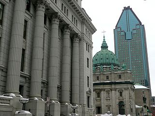
Metcalfe Street is a north–south street located in downtown Montreal, Quebec, Canada. It links Sherbrooke Street in the north and René Lévesque Boulevard in the south. It is best known for being the street on which the Sun Life Building, Mary, Queen of the World Cathedral, and other notable buildings are located. South of René Lévesque Boulevard, the street is known as Cathedral Street. The street borders the eastern side of both Dorchester Square and Place du Canada, to the south.
Ontario Street is an east-west artery in Montreal, Quebec, Canada. It crosses the boroughs of Ville-Marie and Mercier–Hochelaga-Maisonneuve. In the latter borough, the street becomes a mix of residential and commercial and is known as Promenade Ontario.

Rue de la Commune is a road in Old Montreal, Quebec, Canada which is well used both by Montrealers and by tourists, since it is the home of the Pointe-à-Callière Museum and the Old Port of Montreal. It also extends eastward into the Gay Village, and westward into Griffintown, where it turns north to Wellington Street and becomes the beginning of Peel Street. The road follows the original shore of the Saint Lawrence River. The buildings along the north side of the road are former commercial buildings.

Saint Patrick Street is a street in Montreal, Quebec, Canada.


