King's Highway 2, commonly referred to as Highway 2, is the lowest-numbered provincially maintained highway in the Canadian province of Ontario, and was originally part of a series of identically numbered highways which started in Windsor, stretched through Quebec and New Brunswick, and ended in Halifax, Nova Scotia. Prior to the 1990s, Highway 2 travelled through many of the major cities in Southern Ontario, including Windsor, Chatham, London, Brantford, Hamilton, Burlington, Mississauga, Toronto, Oshawa, Belleville, Kingston and Cornwall, and many other smaller towns and communities.

New York State Route 25A (NY 25A) is a state highway on Long Island in New York, United States. It serves as the main east–west route for most of the North Shore of Long Island, running for 73 miles (117 km) from Interstate 495 (I-495) near the Queens–Midtown Tunnel in the New York City borough of Queens to NY 25 in Calverton, Suffolk County. The highway is a northern alternate route of NY 25, which follows a more inland routing along Jericho Turnpike.
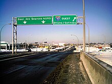
Autoroute 20 is a Quebec Autoroute, following the Saint Lawrence River through one of the more densely populated parts of Canada, with its central section forming the main route of the Trans-Canada Highway from the A-25 interchange to the A-85 interchange. At 585 km (363.5 mi), it is the longest Autoroute in Quebec. It is one of two main links between Montreal and Quebec City; the other is the A-40.
Autoroute 15 is a highway in western Quebec, Canada. It was, until the extension of Autoroute 25 was opened in 2011, the only constructed north-south autoroute to go out of Montreal on both sides. A-15 begins at the end of Interstate 87 at the United States border at Saint-Bernard-de-Lacolle and extends via Montreal to Sainte-Agathe-des-Monts with an eventual continuation beyond Mont-Tremblant. The total length of A-15 is currently 164 km (101.9 mi), including a short concurrency with Autoroute 40 that connects the two main sections. This is one of the few autoroutes in Quebec that does not have any spinoff highways.
Autoroute 10 (A-10) is an Autoroute of Quebec in Canada that links greater Montreal to key population centres in Montérégie and Estrie, including Brossard, Saint-Jean-sur-Richelieu, Granby, and Sherbrooke.

Saint Denis Street is a major north–south thoroughfare in Montreal, Quebec.
Autoroute 440 is a provincial highway that runs across the city of Laval, Quebec from Autoroute 13 to Autoroute 25. It is currently 18.2 km (11.3 mi) long and proceeds across Île Jésus on an east–west axis. It links every highway or expressway that connects Montreal to the North Shore.

Route 363 is a 53 kilometres (33 mi) south-north route in Quebec, Canada, going from Route 138 in Deschambault-Grondines along the St-Lawrence river to Lac-aux-Sables.

Route 117, the Trans Canada Highway Northern Route, is a provincial highway within the Canadian province of Quebec, running between Montreal and the Quebec/Ontario border where it continues as Highway 66 east of McGarry, Ontario. It is an important road since it is the only direct route between southern Quebec and the Abitibi-Témiscamingue region.

U.S. Highway 1 (US 1) in Florida runs 545 miles (877 km) along the state's east coast from Key West to its crossing of the St. Marys River into Georgia north of Boulogne and south of Folkston. US 1 was designated through Florida when the U.S. Numbered Highway System was established in 1926. With the exception of Monroe County, the highway runs through the easternmost tier of counties in the state, connecting numerous towns and cities along its route, including nine county seats. The road is maintained by the Florida Department of Transportation (FDOT).
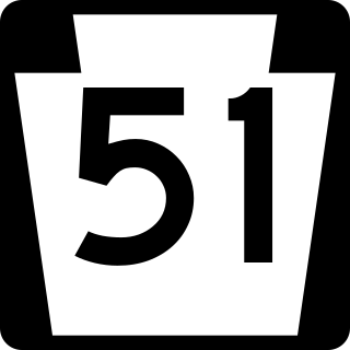
Pennsylvania Route 51 is a major state highway that is located in Western Pennsylvania in the United States. It runs for 89 miles (143 km) from Uniontown to the Ohio state line near Darlington, where it connects with Ohio State Route 14.

U.S. Highway 17 (US 17) in Florida is a north–south United States Numbered Highway that runs 317 miles (510 km) from the Punta Gorda, Florida Metropolitan Statistical Area northeast to the Jacksonville metropolitan area.

Jerome Avenue is one of the longest thoroughfares in the New York City borough of the Bronx, New York, United States. The road is 5.6 miles (9.0 km) long and stretches from Concourse to Woodlawn. Both of these termini are with the Major Deegan Expressway which runs parallel to the west. Most of the elevated IRT Jerome Avenue Line runs along Jerome Avenue. The Cross Bronx Expressway interchanges with Jerome and the Deegan. Though it runs through what is now the West Bronx neighborhood, Jerome Avenue is the dividing avenue between nominal and some named "West" and "East" streets in the Bronx; Fifth Avenue, and to a lesser extent, Broadway, also splits Manhattan into nominal "West" and "East" streets.

Robert Bourassa Boulevard, formerly named University Street, is a major north-south artery in downtown Montreal, Quebec, Canada that is 2.1 km (1.3 mi) in total length.
Gouin Boulevard is the longest street on the Island of Montreal, stretching 57.6 kilometres (35.8 mi) across the north side of the island from Senneville in the west to Pointe-aux-Trembles in the east, where it intersects with Sherbrooke Street.

Côte-Saint-Paul is a neighbourhood located in the Southwest Borough of Montreal, Quebec, Canada.

Saint-Jean Boulevard is a north–south artery located in Quebec, Canada, in the west of the island of Montreal.
Saint-Charles Boulevard is a north-south artery located in Quebec, Canada, in the west of the island of Montreal, colloquially known as West Island among locals.
Lacordaire Boulevard is a north-south thoroughfare in Montreal.