Park Avenue (Montreal)

Last updated
Park Avenue
Le Plateau-Mont-Royal - Avenue du Parc 2.jpg
Park Avenue near Pine Avenue
Native nameavenue du Parc (French)
Length5.7 km (3.5 mi)
Location Montreal
South end Sherbrooke Street
Major
junctions
Quebec Autoroute 40.svgTrans-Canada Highway shield.svg A-40 (TCH)
Qc138.svg R-138
North end Chabanel Street
Jean-Talon Street for the main stretch
South Bleury Street

Park Avenue (officially in French : Avenue du Parc) is one of central Montreal's major north-south streets. It derives its name from Mount Royal Park, by which it runs. Between Mount Royal Avenue and Pine Avenue, the street separates the eastern side of the mountain park and the smaller Jeanne Mance Park (formerly known as Fletcher's Field and often referenced as such in Montreal literature). [1] [2] [3] [4]

Contents

South of Sherbrooke Street (i.e. through the downtown core), the street's name changes to Bleury Street, and south of Saint Antoine Street in Old Montreal, the name changes again to Saint Pierre Street. The northern end of Park Avenue is at Jean Talon Street, at the location of the former Canadian Pacific Railway Park Avenue station, which now serves the Parc Metro and commuter train station. There is also a short stretch of Park Avenue between Crémazie Boulevard and Chabanel Street. [5]

Once one of Montreal's most elegant residential avenues, Park Avenue is now a busy commercial street, home to the former Rialto Theatre. Since 1924, it has also been an important part of Montreal's Greek community.

Park Avenue also lends its name to the Park Extension residential neighbourhood, located at its northern end.

History

Former Rialto Theatre, July 2011. Rialto Theatre Montreal 01.jpg
Former Rialto Theatre, July 2011.

In 1883, a request by English-speaking citizens was filed with the City of Montreal to name the street Park Avenue (in reference to Mount Royal Park, inaugurated in 1876). It was always officially referred to by its English name, Park Avenue, until September 29, 1961, when its French name, Avenue du Parc, was officially recognized.

In 1937, the government planned to change the name of the street to Marconi Street, but it decided to keep its current name following protests by citizens.

A similar event occurred on October 18, 2006 when Mayor Gérald Tremblay proposed to rename Park Avenue (along with Bleury Street) in honour of former Quebec premier Robert Bourassa. On November 28, Montreal City Council voted in favour (40-22) of the motion. [6] If the Commission de toponymie du Québec had approved the change, Park Avenue and Bleury Street in their entirety would have been renamed Robert Bourassa Avenue. The proposal was controversial, especially in light of the historical nature of the name. [7] (The STM's Parc Metro and RTM commuter rail station were to remain "Parc" due to a moratorium on renaming metro stations. [8] ) After Bourassa's family publicly expressed reservations about the controversy, Tremblay announced on February 6, 2007 that he would not pursue the issue further and that the council would be presented with a motion to withdraw the resolution made November 28. (A section of University Street was eventually renamed in honour of Bourassa, instead.)

In 2005, a C$25 million project began to transform the intersection of Pine Avenue and Park, known as the Pine-Park Interchange. Both Park and Pine Avenues remained open while the interchange was being demolished. It was replaced in the summer of 2006 with a more traditional ground-level intersection, which is easier for pedestrians and cyclists to navigate. The interchange had been the only constructed part of the proposed Autoroute 415.

Greektown

Greektown is a proposed name[ by whom? ] for a neighbourhood located on Park Avenue between Mount Royal Avenue and Van Horne Avenue. [9] Historically, Greek influence has been very strong in this area along with the adjoining Park Extension neighbourhood. There are over 61,000 Montrealers of Greek descent. [10]

Montreal's Greektown was where fans celebrated the victory of Greece in the 2004 UEFA European Football Championship. [11]

Public transit

Bus routes along Park Avenue include the STM's 80 Avenue Du Parc, 365 Avenue du Parc and 480 Express du Parc. There are bus lanes along the length of the road (except for the short stretch passing through the borough of Rosemont-La Petite-Patrie). Place-des-Arts metro station is located on the De Bleury section of the street while Parc métro and train station are located near the intersection at Jean-Talon on Hutchison street.

Due to the high volume of bus passengers in the corridor, the city of Montreal has proposed building a tramway along the length of Park Avenue, which is projected to connect the city centre to the Exo's Parc commuter rail station and the Montreal Metro's Parc station. The Autorité régionale de transport métropolitain (ARTM) believes the tram has a potential ridership of 11,600 daily passengers.

See also

Related Research Articles

<span class="mw-page-title-main">Robert Bourassa</span> 20th-century Premier of Quebec

Robert Bourassa was a Canadian lawyer and politician who served as the 22nd premier of Quebec from 1970 to 1976 and from 1985 to 1994. A member of the Liberal Party of Quebec, he served a total of just under 15 years as premier. Bourassa's tenure was marked by major events affecting Quebec, including the October Crisis and the Meech Lake and Charlottetown Accords.

<span class="mw-page-title-main">Notre-Dame-de-Grâce</span> Neighbourhood in Montreal, Quebec, Canada

Notre-Dame-de-Grâce, commonly known as NDG, is a residential neighbourhood of Montreal in the city's West End, with a population of 166,520 (2016). An independent municipality until annexed by the City of Montreal in 1910, NDG is today one half of the borough of Côte-des-Neiges–Notre-Dame-de-Grâce. It comprises two wards, Loyola to the west and Notre-Dame-de-Grâce to the east. NDG is bordered by four independent enclaves; its eastern border is shared with the City of Westmount, Quebec, to the north and west it is bordered by the cities of Montreal West, Hampstead and Côte-Saint-Luc. NDG plays a pivotal role in serving as the commercial and cultural hub for Montreal's predominantly English-speaking West End, with Sherbrooke Street West running the length of the community as the main commercial artery. The community is roughly bounded by Claremont Avenue to the east, Côte-Saint-Luc Road to the north, Brock Avenue in the west, and Highway 20 and the Saint-Jacques Escarpment to the south.

<span class="mw-page-title-main">Orange Line (Montreal Metro)</span> Montreal Metro subway line

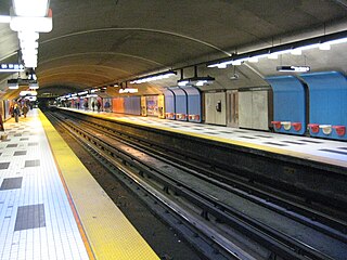
The Orange Line, also known as Line 2, is the longest and first-planned of the four subway lines of the Montreal Metro in Montreal, Quebec, Canada. It formed part of the initial network, and was extended from 1980 to 1986. On April 28, 2007, three new stations in Laval opened making it the second line to leave Montreal Island.

<span class="mw-page-title-main">Henri-Bourassa station</span> Montreal Metro station

Henri-Bourassa station is a Montreal Metro station in the borough of Ahuntsic-Cartierville in Montreal, Quebec, Canada. It is operated by the Société de transport de Montréal (STM) and serves the Orange Line. It is located in the Ahuntsic district. The station opened October 14, 1966, as part of the original network of the Metro. It was the eastern terminal of the Orange Line until 2007, when the line expanded to Montmorency station in Laval.

<span class="mw-page-title-main">Société de transport de Montréal</span> Public transportation organization in Montreal

The Société de transport de Montréal is a public transport agency that operates transit bus and rapid transit services in the urban agglomeration of Montreal, Quebec, Canada. Established in 1861 as the "Montreal City Passenger Railway Company", it has grown to comprise four subway lines with a total of 68 stations, as well as 212 bus routes and 23 night routes. The STM was created in 2002 to replace the Société de transport de la communauté urbaine de Montréal. The STM operates the most heavily used urban mass transit system in Canada, and one of the most heavily used rapid transit systems in North America. As of 2019, the average daily ridership is 2,297,600 passengers: 977,400 by bus, 1,306,500 by rapid transit and 13,700 by paratransit service.

<span class="mw-page-title-main">Ville-Marie, Montreal</span> Borough in Quebec, Canada

Ville-Marie is the name of a borough (arrondissement) in the centre of Montreal, Quebec. The borough is named after Fort Ville-Marie, the French settlement that would later become Montreal, which was located within the present-day borough. Old Montreal is a National Historic Site of Canada.

<span class="mw-page-title-main">Villeray–Saint-Michel–Parc-Extension</span> Borough of Montreal in Quebec, Canada

Villeray–Saint-Michel–Parc-Extension is a borough (arrondissement) in the city of Montreal, Quebec. It had a population of 143,853 according to the 2016 Census and a land area of 16.5 square kilometres (6.4 sq mi).

<span class="mw-page-title-main">Du Ruisseau station</span> Railway station in Montreal, Quebec, Canada

Du Ruisseau station is a future Réseau express métropolitain (REM) station in Montreal, Quebec, Canada, expected to open for REM service by the end of 2024. It was formerly a commuter rail station on the Deux-Montagnes line until Exo ended service in 2020.

<span class="mw-page-title-main">Bois-Franc station</span> Future interchange railway station in Montreal, Canada

Bois-Franc station is a future Réseau express métropolitain (REM) interchange station in the Bois-Franc neighbourhood of Montreal, Quebec, Canada. REM service is expected to begin at the station in the fourth quarter of 2024.

<span class="mw-page-title-main">Le Plateau-Mont-Royal</span> Borough of Montreal in Quebec, Canada

Le Plateau-Mont-Royal is a borough (arrondissement) of the city of Montreal, Quebec, Canada.

<span class="mw-page-title-main">Montreal Metro</span> Metro system in Montreal, Quebec

The Montreal Metro is a rubber-tired underground rapid transit system serving Greater Montreal, Quebec, Canada. The metro, operated by the Société de transport de Montréal (STM), was inaugurated on October 14, 1966, during the tenure of Mayor Jean Drapeau.

<span class="mw-page-title-main">Park Extension</span> Neighbourhood in Montréal, Québec, Canada

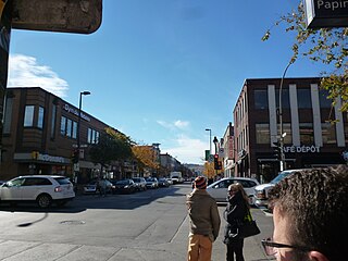
Park Extension is a neighbourhood in the city of Montréal, Québec. It is located in the borough of Villeray–Saint-Michel–Parc-Extension and has a population of 33,800 and an area of 1.6 km2. The name derives from the fact that it is situated at the north end of Park Avenue and is literally an "extension" of the artery. The area is known by locals as "Park Ex."

<span class="mw-page-title-main">Bois-de-Boulogne station</span> Railway station in Montreal, Quebec, Canada

Bois-de-Boulogne station is a commuter rail station operated by Exo in Montreal, Quebec, Canada. It is served by the Saint-Jérôme line.

<span class="mw-page-title-main">Pine Avenue</span>

Pine Avenue is an east–west street in Montreal, Quebec, Canada. This street serves as the dividing line between the downtown Ville-Marie borough and borough of Le Plateau-Mont-Royal, and also serves as the northern border of the Golden Square Mile historic district, further west.

<span class="mw-page-title-main">Papineau Avenue</span> Thoroughfare in Montreal, Canada

Papineau Avenue is the longest north–south street in Montreal, Quebec, Canada. The part of the street between Henri Bourassa Boulevard and Quebec Autoroute 40 is the Montreal portion of Quebec Autoroute 19, commonly referred to as Autoroute Papineau. North of Henri Bourassa Boulevard, it becomes a true autoroute before crossing the Rivière des Prairies on the Papineau-Leblanc Bridge. In the south, the avenue ends at Notre-Dame Street.

Montreal has a developed transport infrastructure network, which includes well-developed air, road, rail, and maritime links to the rest of Canada, as well as the United States and the rest of the world. Local public transport includes a metro system, buses, ferry services and cycling infrastructure.

<span class="mw-page-title-main">Parc station (Montreal)</span> Montreal Metro and railway station

Parc station, also known as Park Avenue station and formerly Jean-Talon station, is a historic railway station building in Montreal, Quebec, Canada. Its western end currently houses the Montreal Metro's Parc station, while businesses occupy the rest of the building. Although the main building no longer serves the railway, the Exo commuter rail Parc station is adjacent to it. It is located on Jean-Talon Street at the end of Park Avenue in the Park Extension neighbourhood of the borough of Villeray–Saint-Michel–Parc-Extension.

<span class="mw-page-title-main">D'Iberville Street</span>

D'Iberville Street is a north-south thoroughfare of Montreal.

References

  1. "Plateau Mont Royal history".
  2. "City of Montreal archives".
  3. "Taylor Noakes website".
  4. Colombo, John Robert (June 1984). Canadian literary landmarks. Hounslow Press. p. 72. ISBN   0-88882-073-9.
  5. Google Map
  6. "'Turn the page' on Park Avenue debate: mayor". CBC News. November 29, 2006.
  7. "Bourassa statue unveiled as street naming stirs controversy". CBC News. October 19, 2006.
  8. "Holà aux changements de nom des stations de métro" (in French). Retrieved 2006-11-28.
  9. Montreal Gazette:City to name Park a Greek village Archived 2012-11-04 at the Wayback Machine
  10. "Ethnocultural Portrait of Canada Highlight Tables, 2006 Census". Archived from the original on 2008-05-23. Retrieved 2012-08-06.
  11. URBANPHOTO: Cities / People / Place » Rebranding Park Avenue

45°30′54.6″N73°35′8.1″W / 45.515167°N 73.585583°W / 45.515167; -73.585583