
Mount Royal is a mountain in the city of Montreal, immediately west of Downtown Montreal, Quebec, Canada. The best-known hypothesis for the origin of the name Montreal is that the mountain is the namesake for the city.

Notre-Dame-de-Grâce, also nicknamed NDG, is a residential neighbourhood of Montreal in the city's West End, with a population of 166,520 (2016). An independent municipality until annexed by the City of Montreal in 1910, NDG is today one half of the borough of Côte-des-Neiges–Notre-Dame-de-Grâce. It comprises two wards, Loyola to the west and Notre-Dame-de-Grâce to the east. NDG is bordered by four independent enclaves; its eastern border is shared with the City of Westmount, Quebec, to the north and west it is bordered by the cities of Montreal West, Hampstead and Côte-Saint-Luc. NDG plays a pivotal role in serving as the commercial and cultural hub for Montreal's predominantly English-speaking West End, with Sherbrooke Street West running the length of the community as the main commercial artery. The community is roughly bounded by Claremont Avenue to the east, Côte-Saint-Luc Road to the north, Brock Avenue in the west, and Highway 20 and the Saint-Jacques Escarpment to the south.

Verdun is a borough (arrondissement) of the city of Montreal, Quebec, located in the southeastern part of the island.
Pointe-Saint-Charles is a neighbourhood in the borough of Le Sud-Ouest in the city of Montreal, Quebec, Canada. Historically a working-class area, the creation of many new housing units, the recycling of industrial buildings into business incubators, lofts, and condos, the 2002 re-opening of the canal as a recreation and tourism area, the improvement of public spaces, and heritage enhancement have all helped transform the neighbourhood and attract new residents. Community groups continue to be pro-active in areas related to the fight against poverty and the improvement of living conditions.

Snowdon station is a Montreal Metro station in the borough of Côte-des-Neiges–Notre-Dame-de-Grâce in Montreal, Quebec, Canada. It is operated by the Société de transport de Montréal (STM) and is a transfer station between the Orange Line and Blue Line; it is the western terminus of the Blue Line. It is located in the Snowdon neighbourhood. The town of Hampstead is located nearby to the west, across Macdonald Avenue; one emergency exit from the station extends into Hampstead.

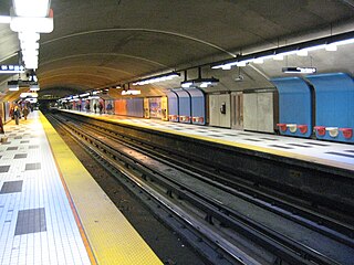
Côte-Sainte-Catherine station is a Montreal Metro station in the borough of Côte-des-Neiges–Notre-Dame-de-Grâce in Montreal, Quebec, Canada. It is operated by the Société de transport de Montréal (STM) and serves the Orange Line. It is located in the Snowdon neighbourhood. The station opened on January 4, 1982, and briefly served as the western terminus of the Orange Line, replacing Snowdon station until Plamondon station opened in June of that year.
Plamondon station is a Montreal Metro station in the borough of Côte-des-Neiges–Notre-Dame-de-Grâce in Montreal, Quebec, Canada. It is operated by the Société de transport de Montréal (STM) and serves the Orange Line. It is located in the Snowdon neighbourhood of Côte-des-Neiges–Notre-Dame-de-Grâce. It opened on June 29, 1982 and replaced Côte-Sainte-Catherine station as the Orange Line's western terminus until the extension to Du Collège station was completed in 1984.

Ville-Marie is the name of a borough (arrondissement) in the centre of Montreal, Quebec. The borough is named after Fort Ville-Marie, the French settlement that would later become Montreal, which was located within the present-day borough. Old Montreal is a National Historic Site of Canada.

Côte-des-Neiges–Notre-Dame-de-Grâce is a borough (arrondissement) of Montreal, Quebec, Canada. The borough was created following the 2002 municipal reorganization of Montreal. It comprises two main neighbourhoods, Côte-des-Neiges and Notre-Dame-de-Grâce, both former towns that were annexed by the city of Montreal in 1910.

Le Sud-Ouest is a borough (arrondissement) of the city of Montreal, Quebec, Canada.
Ville-Émard is a neighbourhood located in the Sud-Ouest borough of Montreal, Quebec, Canada.

Snowdon is a neighbourhood located in Montreal, Quebec, Canada. It is part of the Côte-des-Neiges–Notre-Dame-de-Grâce borough. The area is centred on the intersection of the Décarie Expressway and Queen Mary Road.

Guy Street is a north-south street located in downtown Montreal, Quebec, Canada. Concordia University's Integrated Engineering, Computer Science and Visual Arts Complex is located on this street, as is the John Molson School of Business building. The street is home to the Guy-Concordia Metro station. Guy Street runs through the Little Burgundy and Shaughnessy Village neighbourhoods, and the recently named Quartier Concordia district, before changing to Côte-des-Neiges Road, above Sherbrooke Street.

Côte-des-Neiges Road is a street in Montreal, home to Plaza Côte-des-Neiges. It is served by Métro Côte-des-Neiges and two bus lanes. BIXI bike rental is also available. It extends from the intersection of Sherbrooke Street and Guy Street in the south to Jean-Talon Street and Laird Boulevard in the north, at the border with the Town of Mount Royal. Part of it follows the path of the former Raimbault Creek between the main peak of Mount Royal and Westmount Summit.

Côte-Saint-Paul is a neighbourhood located in the Southwest Borough of Montreal, Quebec, Canada.

Côte-des-Neiges is a neighbourhood of Montreal, Quebec, Canada. It is located at the geographic centre of the Island of Montreal on the western slope of Mount Royal and is part of the borough of Côte-des-Neiges–Notre-Dame-de-Grâce.

Doctor Penfield Avenue is a one-way eastbound street located in the Golden Square Mile neighbourhood of the borough of Ville-Marie in Montreal, Quebec, Canada. Spanning 1.7 kilometres, it begins at Pine Avenue in the east and terminates at McDougall Avenue, to the west. Doctor Penfield Avenue is named after Wilder Penfield (1891–1976), the founder of the Montreal Neurological Institute.

Cité du Havre is a neighbourhood in the borough of Ville-Marie of the city of Montreal, Quebec, Canada. It is located on a narrow man-made peninsula, the Mackay Pier, which was largely built to protect the Old Port of Montreal from the currents of the Saint Lawrence River and from ice banks and floodings in the springtime.

The Îlot-Trafalgar-Gleneagles is a historic block in Montreal, Quebec, Canada, located on Côte-des-Neiges Road, on the west slope of Mount Royal.

Côte-Sainte-Catherine Road is a street in Montreal, Quebec, Canada. It begins at the Décarie Expressway in Snowdon, part of the borough of Côte-des-Neiges–Notre-Dame-de-Grâce, and runs east and southeast along the periphery of Mount Royal to Park Avenue in the Plateau, terminating near Mount Royal Avenue. In between, it crosses Outremont completely and is one of the oldest streets in the borough, having been present at the time Outremont was incorporated in 1875. Outremont's borough hall is located on this street, as is Beaubien Park. Further west in Côte-des-Neiges, it houses the Jewish General Hospital, the CHU Sainte-Justine hospital, Collège Jean-de-Brébeuf, the Montreal Holocaust Museum, and the Segal Centre for Performing Arts.

