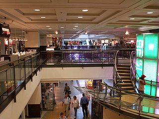
RÉSO, commonly referred to as the Underground City, is the name applied to a series of interconnected office towers, hotels, shopping centres, residential and commercial complexes, convention halls, universities and performing arts venues that form the heart of Montreal's central business district, colloquially referred to as Downtown Montreal. The name refers to the underground connections between the buildings that compose the network, in addition to the network's complete integration with the city's entirely underground rapid transit system, the Montreal Metro. Moreover, the first iteration of the Underground City was developed out of the open pit at the southern entrance to the Mount Royal Tunnel, where Place Ville Marie and Central Station stand today.

Griffintown is a historic neighbourhood of Montreal, Quebec, southwest of downtown. The area existed as a functional neighbourhood from the 1820s until the 1960s and was mainly populated by Irish immigrants and their descendants. Mostly depopulated since then, the neighbourhood has been undergoing redevelopment since the early 2010s.

Duncan McIntyre was a Scots-Quebecer businessman from Callander noted for his participation in the Canadian Pacific Railway syndicate of 1880 and as a founder of the Bell Telephone Company of Canada.

Ville-Marie is the name of a borough (arrondissement) in the centre of Montreal, Quebec. The borough is named after Fort Ville-Marie, the French settlement that would later become Montreal, which was located within the present-day borough. Old Montreal is a National Historic Site of Canada.

Le Sud-Ouest is a borough (arrondissement) of the city of Montreal, Quebec, Canada.

Richard Bladworth Angus was a Scottish-Canadian banker, financier, and philanthropist. He was a co-founder and vice-president of the Canadian Pacific Railway, president of the Bank of Montreal, president of the Royal Victoria Hospital, Montreal, president of the Montreal Art Association, and co-founder and president of the Mount Royal Club. He was the natural successor to Lord Mount Stephen as president of the Canadian Pacific Railway in 1888, but he did not desire the position; he twice refused a knighthood. The CPR Angus Shops were named for him, as was one of the later CP Ships.

Chinatown is a neighborhood located in the area of De la Gauchetière Street in Montreal, Quebec, Canada. The neighbourhood contains many Asian restaurants, food markets, and convenience stores as well being home to many of Montreal's East Asian community centres, such as the Montreal Chinese Hospital and the Montreal Chinese Community and Cultural Centre.

Sainte-Catherine Street is the primary commercial artery of Downtown Montreal, Quebec, Canada. It crosses the central business district from west to east, beginning at the corner of Claremont Avenue and de Maisonneuve Boulevard in Westmount, and ending at the Grace Dart Extended Care Centre by Assomption metro station, where it folds back into Notre-Dame Street. It also traverses Ville-Marie, passing just east of Viau in Mercier–Hochelaga-Maisonneuve. The street is 11.2 km long, and considered the backbone of Downtown Montreal.

Saint Jacques Street, or St. James Street, is a major street in Montreal, Quebec, Canada, running from Old Montreal westward to Lachine.
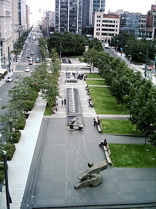
Victoria Square is a town square and public space in the Quartier International de Montréal area of downtown Montreal, Quebec, Canada, at the intersection of Beaver Hall Hill and McGill Street. The Square forms an integral component of the city's urban public transit system and constitutes a 'prestige address' for the international face of the city. It is bordered by Viger Street to the north, Saint Jacques Street to the south, Beaver Hall Hill to the west and Square Victoria Street along the eastern side. As with other city squares, Square Victoria is open 24 hours per day to all citizens of Montreal and provides the role of an urban breathing space, with dense foliage to the south that tapers as the square rises up Beaver Hall Hill.

The Ottawa Hotel in Montreal, Quebec, Canada, was built in 1845 at 50 Saint Jacques Street by George Hall. It is a 19th-century example of an attempt to build a skyscraper. Hall had previously owned a hotel by the same name located at the corner of McGill and St. Maurice Streets from at least 1842.

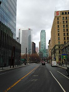
Downtown Montreal is the central business district of Montreal, Quebec, Canada.
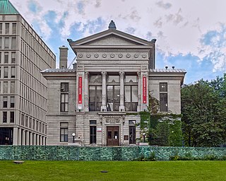
The Redpath Museum is a museum of natural history belonging to McGill University and located on the university's campus on Sherbrooke Street West in Montreal, Quebec, Canada. It was built in 1882 as a gift from the sugar baron Peter Redpath.

McGill College Avenue is a street in downtown Montreal, Quebec, Canada. Named for McGill University, the street was widened in the 1980s and transformed into a scenic avenue with McGill's Roddick Gates on Sherbrooke Street at its north end and the Place Ville Marie plaza at its south end.

Sherbrooke Street is a major east–west artery and at 31.3 kilometres (19.4 mi) in length, is the second longest street on the Island of Montreal, Canada. The street begins in the town of Montreal West and ends on the extreme tip of the island in Pointe-aux-Trembles, intersecting Gouin Boulevard and joining up with Notre-Dame Street. East of Cavendish Boulevard this road is part of Quebec Route 138.

Saint Antoine Street, formerly known as Craig Street, is a street located in Montreal, Quebec, Canada. It runs to the south of Downtown Montreal and north of Old Montreal and Griffintown and Saint-Henri. It crosses the Quartier international de Montréal. Between Atwater Avenue and Greene Avenue, the north side of the street is in Westmount.
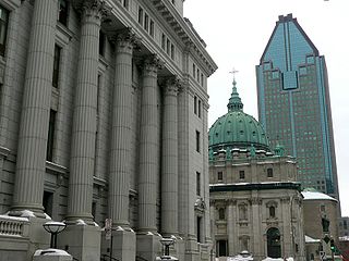
Metcalfe Street is a north–south street located in downtown Montreal, Quebec, Canada. It links Sherbrooke Street in the north and René Lévesque Boulevard in the south. It is best known for being the street on which the Sun Life Building, Mary, Queen of the World Cathedral, and other notable buildings are located. South of René Lévesque Boulevard, the street is known as Cathedral Street. The street borders the eastern side of both Dorchester Square and Place du Canada, to the south.

Dorchester Square, originally Dominion Square, is a large urban square in downtown Montreal. Together with Place du Canada, the area is just over 21,000 m2 (230,000 sq ft) or 2.1 ha of manicured and protected urban parkland bordered by René Lévesque Boulevard to the south, Peel Street to the west, Metcalfe Street to the east and Dorchester Square Street to the north. The square is open to the public 24 hours a day and forms a focal point for pedestrian traffic in the city. Until the creation of Place du Canada in 1967, the name "Dominion Square" had been applied to the entire area.
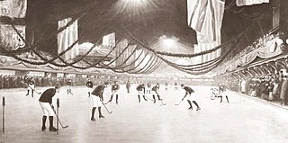
On March 3, 1875, the first recorded indoor ice hockey game took place at the Victoria Skating Rink in Montreal, Quebec. Organized by James Creighton, who captained one of the teams, the game was between two nine-member teams, using a rubber "puck". Members used skates and sticks used for outdoor hockey and shinny games in Nova Scotia, where Creighton was born and raised. It is recognized as the first organized ice hockey game.
Ontario Street is an east-west artery in Montreal, Quebec, Canada. It crosses the boroughs of Ville-Marie and Mercier–Hochelaga-Maisonneuve. In the latter borough, the street becomes a mix of residential and commercial and is known as Promenade Ontario.