Outremont is an affluent residential borough (arrondissement) of the city of Montreal, Quebec, Canada. It consists entirely of the former city on the Island of Montreal in southwestern Quebec. The neighbourhood is inhabited largely by francophones, and is home to a Hasidic Jewish community.

Outremont is a federal electoral district in Montreal, Quebec, Canada, that has been represented in the House of Commons of Canada since 1935. It was known as Outremont—Saint-Jean from 1947 to 1966. Its population in 2006 was 95,711. Its current Member of Parliament is Rachel Bendayan of the Liberal Party of Canada.

Villeray–Saint-Michel–Parc-Extension is a borough (arrondissement) in the city of Montreal, Quebec. It had a population of 143,853 according to the 2016 Census and a land area of 16.5 square kilometres (6.4 sq mi).

Villeray is a neighbourhood in Montreal, Quebec, Canada. It is part of the Villeray–Saint-Michel–Parc-Extension borough and is situated in the north-central part of the Island of Montreal.

Le Plateau-Mont-Royal is a borough (arrondissement) of the city of Montreal, Quebec, Canada.

Ahuntsic-Cartierville is a borough (arrondissement) of the city of Montreal, Quebec, Canada. The borough was created following the 2002 municipal reorganization of Montreal. It comprises two main neighbourhoods, Ahuntsic, a former village annexed to Montreal in 1910 and Cartierville, a town annexed to Montreal in 1916.

Le Moyne is a neighbourhood in Longueuil, Quebec, part of the borough of Le Vieux-Longueuil, and a former city. Le Moyne makes up 2% of the total area of Le Vieux-Longueuil borough and is the only neighbourhood of the borough that was not part of the pre-2002 city of Longueuil. Residents of Le Moyne are called Le Moynois.

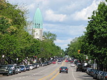
Saint Denis Street is a major north–south thoroughfare in Montreal, Quebec.

Sainte-Rose is a district in Laval, Quebec. It was incorporated as a village in 1850, and was a separate town until the municipal mergers on August 6, 1965 which amalgamated all the municipalities on Île Jésus into a single City of Laval.

Route 335 is a north-south route from Montreal north into the Lanaudière region of Quebec.
Park Extension is a neighbourhood in the city of Montréal, Québec. It is located in the borough of Villeray–Saint-Michel–Parc-Extension and has a population of 33,800 and an area of 1.6 km². The name derives from the fact that it is situated at the north end of Park Avenue and is literally an "extension" of the artery. The area is known by locals as "Park Ex."

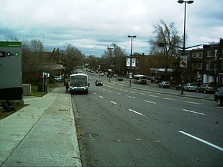
Park Avenue is one of central Montreal's major north-south streets. It derives its name from Mount Royal Park, by which it runs. Between Mount Royal Avenue and Pine Avenue, the street separates the eastern side of the mountain park and the smaller Jeanne Mance Park.

Sherbrooke Street is a major east–west artery and at 31.3 kilometres (19.4 mi) in length, is the second longest street on the Island of Montreal. The street begins in the town of Montreal West and ends on the extreme tip of the island in Pointe-aux-Trembles, intersecting Gouin Boulevard and joining up with Notre-Dame Street. East of Cavendish Boulevard this road is part of Quebec Route 138.
Pie-IX Boulevard, named after Pope Pius IX, is a major boulevard in Montreal, Quebec, Canada. It runs for roughly 11 km (6.8 mi) in a northwest–southeast direction between Henri Bourassa Boulevard and Notre-Dame East. Pie-IX Boulevard runs past the Montreal Botanical Gardens and the Olympic Stadium. The boulevard forms part of Quebec Route 125.
Papineau Avenue is the longest north–south street in Montreal, Quebec, Canada. The part of the street between Henri Bourassa Boulevard and Quebec Autoroute 40 is the Montreal portion of Quebec Autoroute 19, commonly referred to as Autoroute Papineau. North of Henri Bourassa Boulevard, it becomes a true autoroute before crossing the Rivière des Prairies on the Papineau-Leblanc Bridge. In the south, the avenue ends at Notre-Dame Street.
Berri Street is a major north–south street located in Montreal, Quebec, Canada. Berri Street links De la Commune Street in the south and Somerville Street in the north. The street is interrupted between Rosemont Boulevard and Jean Talon Street.

Laurier Avenue is a commercial and residential street in Montreal, Quebec, Canada. It crosses the boroughs of Outremont, Le Plateau-Mont-Royal and Rosemont–La Petite-Patrie. It is known for its cafés, restaurants and specialty stores, especially near Park Avenue and east of Sir Wilfrid Laurier Park.
St. Hubert Street is a north–south street that spans the island of Montreal. It is located east of Berri Street.

Sir Wilfrid Laurier Park is an urban park in the Le Plateau-Mont-Royal borough of Montreal, Quebec, Canada. It is bordered by Laurier Avenue East to the south, De Brébeuf Street to the east, Saint Grégoire Street to the north and De Mentana Street to the west.

D'Iberville Street is a north-south thoroughfare of Montreal.