
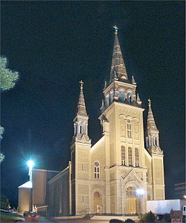
Saint-Vincent-de-Paul is a district in the eastern part of Laval, Quebec, Canada. Saint-Vincent-de-Paul was a town before August 6, 1965. Saint-Vincent-de-Paul is named after Vincent de Paul.
Saint-Vincent-de-Paul is a district in the eastern part of Laval, Quebec, Canada. Saint-Vincent-de-Paul was a town before August 6, 1965. Saint-Vincent-de-Paul is named after Vincent de Paul.
It is surrounded by Duvernay at the west and by Saint-François at the north and east. [1]
The Pie IX Bridge connects St-Vincent-de-Paul and the Montreal borough of Montreal North across the Rivière des Prairies.
Commission scolaire de Laval operates Francophone public schools.
It has one Francophone private school: Collège Laval
Sir Wilfrid Laurier School Board operates Anglophone public schools. Elementary schools serving Saint-Vincent-de-Paul include:
All portions of Laval are zoned to Laval Junior Academy and Laval Senior Academy.

Repentigny is an off-island suburb of Montreal, Quebec, Canada. It is located north of the city on the lower end of the L'Assomption River, and on the Saint Lawrence River. Repentigny and Charlemagne were the first towns off the eastern tip of the Island of Montreal. Repentigny is part of the Lanaudière region.

Terrebonne is an off-island suburb of Montreal, in southwestern Quebec, Canada. It is located on the north shores of the Rivière des Mille-Îles and of the Rivière des Prairies, north of Montreal and Laval.

Mirabel is an off-island suburb of Montreal, located in southern Quebec.
Joliette is a city in southwest Quebec, Canada. It is approximately 50 kilometres (31 mi) northeast of Montreal, on the L'Assomption River and is the seat of the Regional County Municipality of Joliette. The city is home to the Joliette Art Museum, whose works of art include paintings, sculptures, paper artwork and a large collection of art from the French Middle Ages.

La Plaine is an off-island suburb of Montreal, and a formerly incorporated town in southwestern Quebec, Canada. It lies north of Montreal and Laval. It is now part of the city of Terrebonne in the Les Moulins Regional County Municipality. It is part of the administrative division of Lanaudière.

Sainte-Anne-des-Plaines is a city in southwestern Quebec, Canada, 40 km northwest of the city of Montreal in the Thérèse-De Blainville Regional County Municipality, in the region of Laurentides. Its population was 14,990 during the census of 2014.
Rosemère is an affluent off-island suburb of Montreal, in southwestern Quebec, Canada on the north shore of the Rivière des Mille Îles in the Thérèse-De Blainville Regional County Municipality. The town is noted for its green look, due to the high density of trees. Some wooded areas in the town have been left intact as the town has grown around them. Homes are mostly upscale, varying from renovated cottages to unique character homes. It is almost entirely residential, with no significant industries. Boulevard Curé-Labelle, the town's main commercial artery, is lined up by suburban shops and shopping malls, the largest of which is Place Rosemère.
Pont-Viau, Quebec is a district in the southern part of Laval, Quebec, Canada. It was a town before August 6, 1965. It was named after Viau bridge, which links it to Ahuntsic-Cartierville in Montreal, Quebec.
Saint-François is the second largest district of Laval, Quebec, Canada, after Duvernay. It was a separate city until the municipal mergers on August 6, 1965.
Duvernay is a district in the eastern part of Laval and was a separate city until the municipal mergers on August 6, 1965.

Chomedey is a district in the southwest of the city of Laval and was a separate municipality until the municipal mergers in 1965.
Sainte-Dorothée is a district in Laval, Quebec. It was a separate city until the municipal mergers on August 6, 1965.

Fabreville is a district in Laval, Quebec. It was a separate city until the municipal mergers on August 6, 1965.

Sainte-Rose is a district in Laval, Quebec. It was incorporated as a village in 1850, and was a separate town until the municipal mergers on August 6, 1965 which amalgamated all the municipalities on Île Jésus into a single City of Laval.
Vimont is a district in the centre of Laval, Quebec. It was a separate city until the municipal mergers on August 6, 1965. Until 1960 the name was Saint-Elzéar.

The Sir Wilfrid Laurier School Board is a school board headquartered in Rosemère, Quebec in Greater Montreal.
Lavaltrie is a city located within the D'Autray Regional County Municipality in the southern part of the region of Lanaudière, Quebec, Canada, northeast of Montreal outside the suburban sprawl of the northern crown. The population was 13,267 as of the Canada 2011 Census within a land surface area of about 70 square kilometres, with the majority of the territory being used for agricultural activities..

Sainte-Sophie is a municipality in the Laurentides region of Quebec, Canada, part of the La Rivière-du-Nord Regional County Municipality.
The Centre de services scolaire de Laval (CSSDL) is a French-language school service centre in the Canadian province of Quebec. It is headquartered in Laval. As of 2011, the board of the predecessor, Commission scolaire de Laval, oversees fifty-two primary schools, fourteen secondary schools, eight professional development centres, and three adult education centres in Laval.
The Commission scolaire Jérôme-Le Royer was a Catholic school board located on the Island of Montreal in Quebec, Canada. It oversaw French and English schools in the former municipalities of Anjou, Saint-Leonard, Pointe-aux-Trembles and Montreal-Est.
| Neighbourhoods | |||
|---|---|---|---|
| Administration | |||
| Public services | |||
| Education |
| ||
| Other | |||
| General | |
|---|---|
| National libraries | |
| Other | |
Coordinates: 45°37′N73°39′W / 45.617°N 73.650°W
| | This Quebec location article is a stub. You can help Wikipedia by expanding it. |