Laval-Ouest

Last updated

Laval-Ouest
Ville de Laval
Beach Laval West.JPG
Laval Ouest/West - Berge Aux Quatre Vents Summer 1940's
Flag of Laval, Quebec.svg
Coat of Arms Laval West.JPG
Motto(s): 
"Unité, progrès, grandeur"  (French)
"Unity, Progress, Greatness"
Canada Southern Quebec location map.png
Red pog.svg
Laval-Ouest
Location in southern Quebec.
Coordinates: 45°33′N73°52′W / 45.550°N 73.867°W / 45.550; -73.867
CountryCanada
Province Quebec
Region Laval
Municipality Laval
Postal Code
H7R
Area code(s) 450, 579

Laval-Ouest is a district in Laval, Quebec. It was a separate city until the municipal mergers on August 6, 1965.

Contents

Geography

Laval-Ouest is delimited north and north-west by the Rivière des Mille-Îles, south-west by Laval-sur-le-Lac, east by Fabreville and south by Sainte-Dorothée. [1] Also known as Plage Laval.

Demographics

As of 2011 the population of Laval-Ouest was 11369 residents. Of which at least 5875 residents reported being bilingual in both French and English. 4896 residents were unilingual Francophones, and 386 unilingual Anglophones.

History

The municipality of "village de Plage Laval" [2] became the village de Laval-Ouest in 1950. In 1962 it was annexed as part of Sainte-Dorothée, in 1964 it reverted to the City of Laval-Ouest, and in the following year was amalgamated into the ville de Laval.

On April 23, 1926, Warren & Arthur Smadbeck Ltd. acquired land that had previously been used as farmland. The latter were located on the territory of the municipality of the western part of the parish of Sainte-Rose, now called Fabreville.

Warren & Arthur Smadbeck Ltd., based in New York, USA, was involved in the development of several summer resorts along the coasts of Long Island, New York, including Mastic Beach and Amityville. The acquisitions on Île Jésus was to carry out a similar project along the Rivière des Mille Îles, with Montreal residents as their main clients.

A summer village, consisting mainly of chalets built near a beach, was set up by the company, and named of Plage-Laval, borrowing the name of the county of Laval, in which the sector is located. On February 19, 1932, Plage-Laval changed its status to become a city under the Act to incorporate the town of Plage Laval. It created a Bilingual Council, and elected Mr. Taillon as Mayor. The permanent population of the town was 281 residents, with an influx of over 5000 summer vacationers.

In 1950, Plage-Laval enlarged its territory by annexing, on both sides of present-day Boulevard Arthur-Sauvé, part of the territory of the municipality of the parish of Sainte-Rose, situated to the south of boulevard Sainte-Rose.

On 1 January 1951, the municipality changed its name to that of the city of Laval-Ouest. The 1952 census placed the population of the city with 731 French families, 494 English families, 236 Jewish families, and 66 other. In 1960, responding to the citizens' request, the town of Laval-Ouest annexed part of the territory of the municipality of the parish of Sainte-Dorothée, in particular between Boulevard Dagenais and chemin Saint-Antoine, and another Small part of the territory of the city of Fabreville. [3]

On June 18, 1964, the municipality changed its status and became the city of Laval-Ouest [4]

Recreation

Parks

The "Berge aux Quatre-Vents" is a large public park and beach located in Laval-Ouest along the shores of the Milles-Illes river. It has sandy beaches and plenty of recreational green space and is open year-round. It is home to a variety of wild life including Canada Geese, Ducks, and Grand herons. During the summer the park is home to many concerts and musical spectacles. In the winter the area is a magnet for ice fishing.

Parc Laval Ouest is located both along Ch. Sainte-Antoine and 21E Avenue and contains both a football and soccer field, and small skateboard park, as well as a baseball diamond, and a contained dog walk park.

Berge de L'Anse located at the junction of 7E and 3E Avenues has a boat launch with parking adequate for vehicles with trailers as well as a small green space with benches.

Parc Nordier located at the corner of 33E Avenue and 24E Rue, just beside the fire station, is a smaller park with a sandbox and jungle gym.

Parc Ringuet with entrances both on Arthur-Sauve (behind the Library) and 49E Avenue contains a variety of child activities, as well as several multi use courts. [5]

Skating / Hockey Arena

Aréna Hartland-Monahan Located on Arthur-Sauve is full sized indoor skating rink, with WIFI access on site.

Maison des Jeunes

La Masion des Jeunes de Laval Ouest Located at 3850 boulevard Ste-Rose is a community non-profit youth organization that has existed in the neighborhood since January 1992. The center has many different activities, such as a basketball team, as well as a Role Playing Game club.

Zones musicales

During the summer season the "Berge aux Quatre-Vents" is home to one of Laval's outdoor concert venues located at 925 Rue Riviera [6]

Education

Commission scolaire de Laval operates Francophone public schools.

Sir Wilfrid Laurier School Board operates Anglophone public schools.

Historical Sites

Laval Ouest is the home to the oldest synagogue in the city of laval. The "Beth Abraham" located in a bungalow that seats about 100, was opened around 1940 in what was then known as "Laval West". In the 1930s, the then rural area with its beaches was a popular summer getaway for many Jewish families who rented summer homes there. The synagogue served summer residents till the mid-1970s and continues to be maintained, although it is only used now on the High Holy Days.

Related Research Articles

<span class="mw-page-title-main">Laval, Quebec</span> City in Quebec, Canada

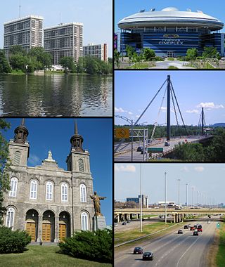
Laval is a city in Quebec, Canada. It is in the southwest of the province, north of Montreal. It is the largest suburb of Montreal, the third-largest city in the province after Montreal and Quebec City, and the thirteenth largest city in Canada, with a population of 443,192 in 2021.

<span class="mw-page-title-main">Île Jésus</span> Large river island in Quebec, Canada

Île Jésus is a river island in southwestern Quebec, separated from the mainland to the north by the Rivière des Mille Îles, and from the Island of Montreal to the south by the Rivière des Prairies. It is the second-largest island in the Hochelaga Archipelago, and the fourth most populous island in Canada, with more than 420,000 residents as of 2016.

<span class="mw-page-title-main">Terrebonne, Quebec</span> City in Quebec, Canada

Terrebonne is an off-island suburb of Montreal, in southwestern Quebec, Canada. It is located in the North Shore region of the Montreal area, north of Laval across the Rivière des Mille-Îles.

<span class="mw-page-title-main">Saint-Eustache, Quebec</span> City in Quebec, Canada

Saint-Eustache is an off-island suburb of Montreal, in western Quebec, Canada, west of Montreal on the north shore of the Rivière des Mille Îles. It is located 35 km (22 mi) northwest of Montreal.

<span class="mw-page-title-main">Mirabel, Quebec</span> City in Canada

Mirabel is a suburb of Montreal, located on the North Shore in southern Quebec.

<span class="mw-page-title-main">Laval—Les Îles</span> Federal electoral district in Quebec, Canada

Laval—Les Îles is a federal electoral district in Quebec, Canada, that has been represented in the House of Commons of Canada since 2004.

<span class="mw-page-title-main">Sainte-Anne-des-Plaines</span> City in Quebec, Canada

Sainte-Anne-des-Plaines is a city in southwestern Quebec, Canada, 40 km northwest of the city of Montreal in the Thérèse-De Blainville Regional County Municipality, in the region of Laurentides. Its population was 14,990 during the census of 2014.

<span class="mw-page-title-main">Rosemère</span> City in Quebec, Canada

Rosemère is an affluent suburb of Montreal, in southwestern Quebec, Canada on the north shore of the Rivière des Mille Îles in the Thérèse-De Blainville Regional County Municipality. The town is noted for its green look, due to the high density of trees. Some wooded areas in the town have been left intact as the town has grown around them. Homes are mostly upscale, varying from renovated cottages to unique character homes. It is almost entirely residential, with no significant industries. Boulevard Curé-Labelle, the town's main commercial artery, is lined up by suburban shops and shopping malls, the largest of which is Place Rosemère.

<span class="mw-page-title-main">Lorraine, Quebec</span> City in Quebec, Canada

Lorraine is an affluent off-island suburb of Montreal, in southwestern Quebec, Canada on the north shore of the Rivière des Mille-Îles in the Thérèse-De Blainville Regional County Municipality. There are no industries and only a very limited commercial district ; almost all houses are of the detached type. Furthermore, a large portion of the town territory is set aside as wild forest ; some bike/ski trails run through it. The town is divided into two areas, Uptown and Downtown. These two areas are also delimited by Quebec freeway A-640, and are only joined together by the main street overpass.

<span class="mw-page-title-main">Ahuntsic-Cartierville</span> Borough of Montreal in Quebec, Canada

Ahuntsic-Cartierville is a borough (arrondissement) of the city of Montreal, Quebec, Canada. The borough was created following the 2002 municipal reorganization of Montreal. It comprises two main neighbourhoods, Ahuntsic, a former village annexed to Montreal in 1910 and Cartierville, a town annexed to Montreal in 1916.

<span class="mw-page-title-main">Le Vésinet</span> Commune in Île-de-France, France

Le Vésinet is a suburban commune in the Yvelines department in the Île-de-France region in north-central France. It is a part of the affluent outer suburbs of western Paris, 16.4 km (10.2 mi) from the centre of Paris.

<span class="mw-page-title-main">Chomedey, Quebec</span> Former city in Quebec, Canada

Chomedey is a district in the southwest of the city of Laval and was a separate municipality until the municipal mergers in 1965.

<span class="mw-page-title-main">Auteuil, Quebec</span> Place in Quebec, Canada

Auteuil is a district of Laval in Quebec, Canada. It is delimited in the north-west by the Rivière des Mille-Îles, north-east by Saint-François, south-east by Duvernay, south by Vimont and south-west by Sainte-Rose.

Sainte-Dorothée is a district in Laval, Quebec. It was a separate city until the municipal mergers on August 6, 1965.

<span class="mw-page-title-main">Fabreville, Quebec</span>

Fabreville is a district in Laval, Quebec. It was a separate city until the municipal mergers on August 6, 1965.

<span class="mw-page-title-main">Sainte-Rose, Quebec</span>

Sainte-Rose is a district in Laval, Quebec. It was incorporated as a village in 1850, and was a separate town until the municipal mergers on August 6, 1965 which amalgamated all the municipalities on Île Jésus into a single City of Laval.

<span class="mw-page-title-main">Bois-des-Filion</span> City in Quebec, Canada

Bois-des-Filion is an off-island suburb of Montreal, located in Quebec, Canada, to the north of Montreal.

<span class="mw-page-title-main">Pointe-Calumet</span> Municipality in Quebec, Canada

Pointe-Calumet is a municipality in the Canadian province of Quebec. The municipality is located within the Deux-Montagnes Regional County Municipality in the Laurentides region. It is situated about 30 minutes northwest of Montreal. Its population as of the 2006 Canadian Census is just over 6 000.

<span class="mw-page-title-main">Saint-Joseph-du-Lac</span> Municipality in Quebec, Canada

Saint-Joseph-du-Lac is a municipality in the Laurentides region of Quebec, Canada, part of the Deux-Montagnes Regional County Municipality.

The Centre de services scolaire de Laval (CSSDL) is a French-language school service centre in the Canadian province of Quebec. It is headquartered in Laval. As of 2011, the board of the predecessor, Commission scolaire de Laval, managed fifty-two primary schools, fourteen secondary schools, eight professional development centres, and three adult education centres in Laval.

References

  1. Interactive map of Laval from the official website Archived 7 April 2005 at the Wayback Machine Shows both the borders and names of the 14 former municipalities (purple) and the borders only of the current 6 sectors (maroon), tick off both boxes beside "Limite administrative".[ dead link ]
  2. "Accueil" (PDF). Archived from the original (PDF) on 4 January 2018. Retrieved 2 July 2017.
  3. L’ENVOL BULLETIN D’INFORMATION Printemps Assoc des emp retrates de ville de laval 2016 P.9-13
  4. "Accueil" (PDF). Archived from the original (PDF) on 4 January 2018. Retrieved 2 July 2017.
  5. "Ville de Laval - Parcs et espaces verts".
  6. "Zones musicales - Zone 5 : Berge aux Quatre-Vents".
  7. "Fleur-de-Vie Archived 24 September 2017 at the Wayback Machine ." Commission scolaire de Laval. September 24, 2017.
  8. "Raymond (Pavillons Sud et Nord) Archived 24 September 2017 at the Wayback Machine ." Commission scolaire de Laval. September 24, 2017.
  9. "Sir Wilfrid Laurier School Board". Archived from the original on 5 March 2021. Retrieved 29 December 2021.