On April 1, 1961, the towns of Renaud, Quebec[fr] and L'Abord-à-Plouffe[fr] and the city of Saint-Martin were merged, giving birth to the city of Chomedey. Chomedey's city hall became the city hall for all of Laval. The merger project was first launched by the administration of the city of L'Abord à Plouffe. On August 10, 1960, it passed a resolution expressing its desire to merge the three municipalities and the city of Laval-des-Rapides, under the name "Cité de Laval". Renaud (Laval)
Eight days later, Laval-des-Rapides, withdrew from the merger project. Hesitation was also felt the city of Renaud, where a referendum was held on the issue. On January 16, 1961 The referendum was won by the "fusionist", and the birth of the new city was celebrated by civic festivities, held from October 8 to 15, 1961.
From then and onward, Chomedey stood out as a modern city, whose residential and industrial development excelled. The growth of Chomedey on the industrial front was rapid: the city had welcomed 1 new industry per month for 2 consecutive years, between 1962 and 1964.
In short, Chomedey quickly became a city in its own right. This amalgamated municipality was already expanding, shortly after its creation. In 1963, the new city studied the possibility of annexing her two neighbours, the towns of Sainte-Dorothée and Fabreville.
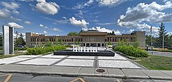
In 1964, the city inaugurated the new city hall. The building, designed according to the plans of the architects Affleck, Desbarats, Dimakopoulos, Lebensold and Sise, was to be part of an architectural ensemble that would constitute the Civic Center of Chomedey to house various services, including a library, a theater and an art center. The planned complex was not realized until the creation of the City of Laval.[1]
Since the 1960s, Chomedey is the most multicultural neighbourhood of Laval. It includes a large number of Jews, Christians, Muslims, Portuguese, Lebanese, Algerians, Moroccans, Syrians, Egyptians, Haitians, Italians, Armenians and the largest Greek community of Quebec. Mirroring the geographic linguistic divisions in Montreal, there are more English-speakers in the west of Ile Jesus than in the east, and Chomedey has been home to the city's Anglophone and allophone minorities, notably a large community of Greeks.[3]
The main thoroughfares are Curé-Labelle Blvd, Chomedey Blvd, Saint-Martin Blvd, Souvenir Rd, Notre-Dame Blvd, Samson Blvd, 100th Ave, Daniel-Johnson Blvd, Le Carrefour Blvd, Le Corbusier Blvd, Armand-Frappier Blvd, Cartier Blvd, Lévesque Blvd, Promenade Des Îles, Cléroux Blvd, Jean-Béraud Ave, Pierre-Péladeau Ave, Bois-de-Boulogne Ave, Avenir Blvd, Industriel Blvd, McNamara St, Terry-Fox Ave, Louis-Payette Ave and Perron Blvd.
Because of the rapid densification of this neighborhood and the development of the last fields and forested areas, there are more and more cars on the road. Since 2000, it is not uncommon to be in a traffic jam on many of main thoroughfares. Curé-Labelle Blvd, Chomedey Blvd, Saint-Martin Blvd, Notre-Dame Blvd and Le Corbusier Blvd are often subject to traffic jams, but the creation of reserved bus lanes, an expanded bike path network as well as the extension of the Metro into Laval are all helping Chomedians to favor more sustainable transit alternatives.
Traffic is a common problem, with many residents travelling to Montreal combined with Laurentians-Montreal commuter and cottage traffic.
According to the 2001 Census 28% spoke only French, 10% English, 58% were bilingual in both French and English and 3% spoke other languages than French and English.[16]
The postal codes for this area begin with H7S, H7T, H7V, H7N and H7W. Land-based telephone numbers are assigned the 450 area code.
Historical & Sites of Interest
The Cosmodome located on Autoroute 15 is the only museum in Canada dedicated solely to the space sciences and houses one of two lunar rocks on display in Canada.[17]
The Armand Frappier Museum located on Blvd. des Prairies is a biotechnology museum named after Dr.Armand Frappier who was instrumental in the fight against tuberculosis in Canada [18][19]
Église and Park Saint-Maxime, between 77e and 80e Avenue. Saint-Maxime parish, formed from Saint-Martin parish, was established in 1928. Prior to the church's construction in 1958, religious services were celebrated in the first École Saint-Maxime, located at 3781, boulevard Lévesque.[20]
Église Saint-Martin
The Lachapelle bridge, located on Blvd. Labelle connecting Montreal and Laval. The present-day metal Lachapelle bridge dates from 1890 and was doubled in size in 1977 after undergoing extensive modifications in 1940. The first bridge that linked the banks of Montréal and île Jésus was built of wood around 1848 and replaced the ferry that brought travellers from Cartierville to L'Abord-à-Plouffe. It was called the Cartierville bridge for a long time.[20]
The Centre du Sablon located on Ch. du Sablon is run by the Corporation du centre du Sablon, a non-profit organization. The City of Laval purchased the building from the Jewish community in 1992, where it was formerly a YMHA. The Centre seeks to satisfy residents' social, recreational and cultural needs by offering a wide range of activities aimed at different age groups.[21]
The Saint-Martin parish church Église Saint-Martin located on St. Martin, near Blvd. Labelle, was built in 1782, and was the first church on île Jésus located at a crossroads inland. The second church, erected in 1874, just southeast of the first one, designed by the architects Bourgeau and Leprohon, was destroyed in 1942 by lightning. It was replaced in 1949 by the existing church, built facing boulevard Saint-Martin, over 120 m away.[20]
Related Research Articles
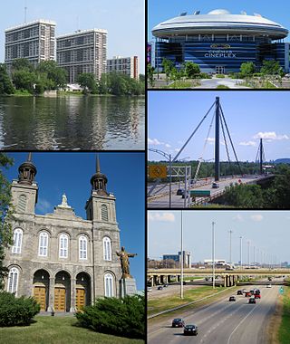
Laval is a city in Quebec, Canada. It is in the southwest of the province, north of Montreal. It is the largest suburb of Montreal, the third-largest city in the province after Montreal and Quebec City, and the thirteenth largest city in Canada, with a population of 443,192 in 2021.
Saint-Eustache is an off-island suburb of Montreal, in western Quebec, Canada, west of Montreal on the north shore of the Rivière des Mille Îles. It is located 35 km (22 mi) northwest of Montreal.
Mirabel is a suburb of Montreal, located on the North Shore in southern Quebec.
La Plaine is an off-island suburb of Montreal, and a former city in southwestern Quebec, Canada. It lies north of Montreal and Laval. It is now part of the city of Terrebonne in the Les Moulins Regional County Municipality. It is part of the administrative division of Lanaudière.
Sainte-Anne-des-Plaines is a city in southwestern Quebec, Canada, 40 km northwest of the city of Montreal in the Thérèse-De Blainville Regional County Municipality, in the region of Laurentides. Its population was 14,990 during the census of 2014.
Rosemère is an affluent suburb of Montreal, in southwestern Quebec, Canada on the north shore of the Rivière des Mille Îles in the Thérèse-De Blainville Regional County Municipality. The town is noted for its green look, due to the high density of trees. Some wooded areas in the town have been left intact as the town has grown around them. Homes are mostly upscale, varying from renovated cottages to unique character homes. It is almost entirely residential, with no significant industries. Boulevard Curé-Labelle, the town's main commercial artery, is lined up by suburban shops and shopping malls, the largest of which is Place Rosemère.
Laval-des-Rapides is a district in Laval, Quebec, Canada. It was a separate city until the municipal mergers on August 6, 1965.
Saint-Vincent-de-Paul is a district in the eastern part of Laval, Quebec, Canada. Saint-Vincent-de-Paul was a town before August 6, 1965. Saint-Vincent-de-Paul is named after Vincent de Paul.
Montreal North is a borough within the city of Montreal, Canada. It consists entirely of the former city of Montreal North on the Island of Montreal in southwestern Quebec. It was amalgamated into the City of Montreal on January 1, 2002.
Saint-François is the second largest district of Laval, Quebec, Canada, after Duvernay. It was a separate city until the municipal mergers on August 6, 1965.
Duvernay is a district in the eastern part of Laval and was a separate city until the municipal mergers on August 6, 1965.
Sainte-Dorothée is a district in Laval, Quebec. It was a separate city until the municipal mergers on August 6, 1965.
Fabreville is a district in Laval, Quebec. It was a separate city until the municipal mergers on August 6, 1965.
Sainte-Rose is a district in Laval, Quebec. It was incorporated as a village in 1850, and was a separate town until the municipal mergers on August 6, 1965 which amalgamated all the municipalities on Île Jésus into a single City of Laval.
Vimont is a district in the centre of Laval, Quebec. It was a separate city until the municipal mergers on August 6, 1965. Until 1960 the name was Saint-Elzéar.
Saint-Jean-de-Matha is a municipality located within the Matawinie Regional County Municipality, Quebec, Canada, in the Lanaudière region.
Lavaltrie is a city located within the D'Autray Regional County Municipality in the southern part of the region of Lanaudière, Quebec, Canada, northeast of Montreal outside the suburban sprawl of the North Shore. The population was 14,425 as of the Canada 2021 Census within a land surface area of about 70 square kilometres, with the majority of the territory being used for agricultural activities..
Saint-Martin is a former city, now part of the Chomedey neighbourhood of the city of Laval, Quebec, Canada, corresponding roughly to the Roman Catholic parish of Saint-Martin.
The Centre de services scolaire de Laval is a French-language school service centre in the Canadian province of Quebec. It is headquartered in Laval. As of 2011, the board of the predecessor, Commission scolaire de Laval, managed fifty-two primary schools, fourteen secondary schools, eight professional development centres, and three adult education centres in Laval.
The Commission scolaire Jérôme-Le Royer was a Catholic school board located on the Island of Montreal in Quebec, Canada. It oversaw French and English schools in the former independent municipalities of Anjou, Saint-Leonard, and Montreal-Est as well as the city of Montreal's borough of Pointe-aux-Trembles
↑ Interactive map of Laval from the official website Shows both the borders and names of the 14 former municipalities (purple) and the borders only of the current 6 sectors (maroon), tick off both boxes beside "Limite administrative".
1 2 "About Us." Souvenir Elementary School. Retrieved on September 17, 2017. "It is located 20 km north of Montreal close to Autoroute 13 in the Chomedey area of Laval." - This page has a text description of the attendance boundary. See also: "SOUVENIR ELEMENTARY ZONEArchived 17 September 2017 at the Wayback Machine "
This page is based on this Wikipedia article Text is available under the CC BY-SA 4.0 license; additional terms may apply. Images, videos and audio are available under their respective licenses.