
The St. Lawrence River is a large international river in the middle latitudes of North America connecting the Great Lakes to the North Atlantic Ocean. Its waters flow in a northeasterly direction from Lake Ontario to the Gulf of St. Lawrence, traversing Ontario and Quebec in Canada and New York in the United States. A section of the river demarcates the Canada–U.S. border.

The Island of Montreal is an island in southwestern Quebec, Canada, which is the site of a number of municipalities, including most of the city of Montreal, and is the most populous island in Canada. It is the main island of the Hochelaga Archipelago at the confluence of the Saint Lawrence and Ottawa rivers.

Lake Saint-Louis is a lake in southwestern Quebec, Canada, at the confluence of the Saint Lawrence and Ottawa rivers. The Saint Lawrence Seaway passes through the lake.
The Lachine Canal is a canal passing through the southwestern part of the Island of Montreal, Quebec, Canada, running 14.5 kilometres from the Old Port of Montreal to Lake Saint-Louis, through the boroughs of Lachine, Lasalle and Sud-Ouest.

LaSalle is the most southerly borough (arrondissement) of the city of Montreal, Quebec, Canada. It is located in the south-west portion of the Island of Montreal, along the Saint Lawrence River. Prior to 2002, it was a separate municipality that had been incorporated in 1912.

Verdun is a borough (arrondissement) of the city of Montreal, Quebec, located in the southeastern part of the island.

Hochelaga was a St. Lawrence Iroquois 16th century fortified village on or near Mount Royal in present-day Montreal, Quebec, Canada. Jacques Cartier arrived by boat on October 2, 1535; he visited the village on the following day. He was greeted well by the Iroquois, and named the mountain he saw nearby Mount Royal. Several names in and around Montreal and the Hochelaga Archipelago can be traced back to him.
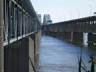
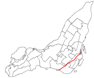
The Honoré Mercier Bridge in Quebec, Canada, connects the Montreal borough of LaSalle on the Island of Montreal with the Mohawk reserve of Kahnawake and the suburb of Châteauguay on the south shore of the Saint Lawrence River. It is the most direct southerly route from the island of Montreal toward the US border. It carries Route 138, originally Route 4. It is 1.361 km (0.846 mi) in length and contains four steel trusses on its first section. The height of the bridge varies from 12.44 m (40.8 ft) to 33.38 m (109.5 ft) with the highest sections located over the St. Lawrence Seaway. The bridge is named after former premier of Quebec Honoré Mercier.

Lachine is a borough (arrondissement) within the city of Montreal on the Island of Montreal in southwestern Quebec, Canada.
The Montreal and Lachine Railroad was Montreal's first railroad. The railroad was opened on November 19, 1847, with service between Bonaventure Station in Montreal and the St. Lawrence River in Lachine. Built to bypass the Lachine Rapids, it was 12 km long. The railway merged with the Lake St. Louis and Province Railroad in 1850 under the name Montreal and New York Railroad. In 1857, it merged with the Champlain and St. Lawrence Railroad as the Montreal and Champlain Railroad. It would eventually be absorbed by the Grand Trunk Railway.

The Old Port of Montreal is the historic port of Montreal, Quebec, Canada. Located adjacent to Old Montreal, it stretches for over 2 km (1.2 mi) along the Saint Lawrence River. It was used as early as 1611, when French fur traders used it as a trading post.
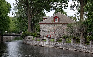
The Fur Trade at Lachine National Historic Site is a historic building located in the borough of Lachine in Montreal, Quebec, Canada, at the western end of the Lachine Canal. It is a National Historic Site of Canada.
The Soulanges Canal is an abandoned shipping canal in Quebec, Canada. It follows the north shore of the Saint Lawrence River between Pointe-des-Cascades and Coteaux-Landing, bypassing the rapids between Lake Saint-Louis and Lake Saint-Francis. In between, it passes through the towns of Les Cèdres and Coteau-du-Lac. It superseded the first Beauharnois Canal which was on the south shore of the Saint Lawrence. It is 23 kilometres (14 mi) long and had a 4.3-metre (14.1 ft) draught. Five locks measuring 85.3 m × 14 m give a total rise of 25 metres (82 ft).

Saint-Jacques River is a river in southwestern Quebec, Canada that drains the Saint Lawrence Lowlands. It flows in a general south to north direction, from the area around Saint-Jacques-le-Mineur to its mouth in the Saint Lawrence River, at the border between the cities of Brossard and La Prairie.
Events from the year 1611 in Quebec.
The Canal de l'Aqueduc is an open-air aqueduct canal on the Island of Montreal in Quebec, Canada, serving part of the drinking water needs of the city of Montreal.
The timeline of Montreal history is a chronology of significant events in the history of Montreal, Canada's second-most populated city, with about 3.5 million residents in 2018, and the fourth-largest French-speaking city in the world.

Habitat 67 is the name of a standing wave on the Saint Lawrence River in Montreal, Quebec, Canada. Informally named for the adjacent Habitat 67 housing complex, it has become a popular destination for whitewater kayaking and river surfing.
The Rivière Brûlé is a tributary of the Sainte-Anne River, flowing on the north bank of the Saint Lawrence River, in the non-territory organized from Lac-Jacques-Cartier, in the La Côte-de-Beaupré Regional County Municipality, in the administrative region of Capitale-Nationale, in the province of Quebec, in Canada.


