The St. Lawrence River is a large international river in the middle latitudes of North America connecting the Great Lakes to the North Atlantic Ocean. Its waters flow in a northeasterly direction from Lake Ontario to the Gulf of St. Lawrence, traversing Ontario and Quebec in Canada and New York in the United States. A section of the river demarcates the Canada–U.S. border.

The Island of Montreal is a large island in southwestern Quebec, Canada, that is the site of a number of municipalities, including most of the city of Montreal, and is the most populous island in Canada. It is the main island of the Hochelaga Archipelago at the confluence of the Saint Lawrence and Ottawa rivers.

Sainte-Anne-de-Bellevue is an on-island suburb located at the western tip of the Island of Montreal in southwestern Quebec, Canada. It is the second oldest community in Montreal's West Island, having been founded as a parish in 1703. The oldest, Dorval, was founded in 1667.
Lake Saint Pierre is a lake in Quebec, Canada, a widening of the Saint Lawrence River between Sorel-Tracy and Trois-Rivières. It is located downstream, and northeast, of Montreal; and upstream, and southwest, of Quebec City. The end of the lake delimits the beginning of the estuary of Saint Lawrence.

The Lachine Rapids are a series of rapids on the Saint Lawrence River, between the Island of Montreal and the South Shore. They are located near the former city of Lachine. The Lachine Rapids contain large standing waves because the water volume and current do not change with respect to the permanent features in the riverbed, namely its shelf-like drops. Seasonal variation in the water flow does not change the position of the waves, although it does change their size and shape. The rapids are about 4.8 kilometres (3.0 mi) in length. In the past these represented a considerable barrier to maritime traffic. Until the construction of the Lachine Canal through Montreal, the rapids had to be portaged. Even with the canal, the difficulty was such that it was usually more convenient to ship goods by rail to Montreal, where they could be loaded at the city's port. Montreal remains a major rail hub and one of Canada's largest ports for that reason.

The West Island is the unofficial name given to the city, towns and boroughs at the western end of the Island of Montreal, in Quebec, Canada. It is generally considered to consist of the Lakeshore municipalities of Lachine, Dorval, Pointe-Claire, and Beaconsfield, the municipalities of Kirkland, Dollard-des-Ormeaux, Baie-D'Urfé, Sainte-Anne-de-Bellevue, the village of Senneville, and two North Shore boroughs of the city of Montreal: Pierrefonds-Roxboro and L'Île-Bizard–Sainte-Geneviève.

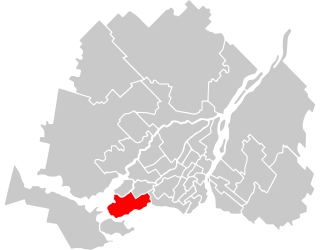
Pointe-Claire is a Quebec local municipality within the Urban agglomeration of Montreal on the Island of Montreal in Canada. It is entirely developed, and land use includes residential, light manufacturing, and retail. As of the 2021 census the population was 33,488.
Vaudreuil-Soulanges is a regional county municipality in Quebec, Canada. It is located on a triangular peninsula in the western Montérégie region of Quebec, formed by the confluence of the Ottawa River to the north, and the St. Lawrence River to the south. Ontario is located west of here.
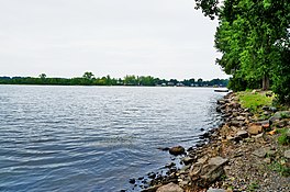
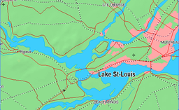
Lac-Saint-Louis is a federal electoral district in Quebec, Canada, that has been represented in the House of Commons of Canada since 1997. Its population was 108,579 at the 2016 Canadian Census.
The 2000–2006 municipal reorganization in Quebec resulted in large-scale amalgamation of smaller municipalities in Quebec into larger cities. It was undertaken by one administration, but was modified and partially undone by its successor.

The Beauharnois Canal is located in southwestern Quebec, Canada. The canal is part of the Saint Lawrence Seaway.
Lake of Two Mountains is part of the river delta widening of the Ottawa River in Quebec, Canada, at its confluence with the St. Lawrence River.

Coteau-du-Lac Canal is an 18th-century military canal in Canada located at the junction of the Delisle and Saint Lawrence Rivers in Quebec. The canal was the first work of its kind in North America, and is a National Historic Site of Canada, which also includes the remains of a fort and reconstructed blockhouse. It is located in the town of Coteau-du-Lac in Vaudreuil-Soulanges Regional County Municipality.
The Soulanges Canal is an abandoned shipping canal in Quebec, Canada. It follows the north shore of the Saint Lawrence River between Pointe-des-Cascades and Coteaux-Landing, bypassing the rapids between Lake Saint-Louis and Lake Saint-Francis. In between, it passes through the towns of Les Cèdres and Coteau-du-Lac. It superseded the first Beauharnois Canal which was on the south shore of the Saint Lawrence. It is 23 kilometres (14 mi) long and had a 4.3-metre (14.1 ft) draught. Five locks measuring 85.3 m × 14 m give a total rise of 25 metres (82 ft).

Pointe-des-Cascades is a village municipality in Vaudreuil-Soulanges Regional County Municipality in the Montérégie region of Quebec, Canada. It is located on a spit of land where the St. Lawrence River flows into Lake Saint-Louis. The river has here a significant drop, forming several cascades which give the village its name. The islands of Île des Cascades and Île des Joybert are connected by a narrow causeway, but Île des Cascades and Pointe-des-Cascades are only connected artificially.

The Saint Charles River is a branch of the Saint Lawrence River that starts in Salaberry-de-Valleyfield, Quebec, Canada. The river divides the Grande-Île and the Island of Salaberry, which are located approximately 50 km east of Montreal. The river is 8 km long, and drops 24m over its course from Lake Saint Francis east to Lake Saint-Louis.
The Saint-Louis river is a tributary of the south shore of the Saint Lawrence River. This river flows through the municipalities of Sainte-Barbe, Saint-Stanislas-de-Kostka, Saint-Louis-de-Gonzague, Saint-Étienne-de-Beauharnois and Beauharnois, in the Beauharnois-Salaberry Regional County Municipality, in the administrative region of Montérégie, in the Southwest of province of Quebec, in Canada.