Yellow Line (Montreal Metro)

Last updated
Yellow Line / Ligne Jaune
Montreal public transit icons - Metro 4.svg Montreal public transit icons - Metro 4 SPS.svg
Jean Drapeau Station.JPG
Jean-Drapeau station
Overview
Native nameLigne Jaune
Line number4
Locale Montreal, Quebec, Canada
Termini
Stations3
Service
Type Rapid transit
System Montreal Metro
Operator(s) Société de transport de Montréal (STM)
Depot(s)None (Berri-UQAM connecting track links line 4 with lines 1 and 2 so that trains can access Angrignon, Beaugrand and Plateau d'Youville garages)
Rolling stock Bombardier Transportation MR-73 cars
History
OpenedApril 1, 1967 (opened to public April 28, 1967)
1988Berri-de-Montigny renamed Berri–UQAM
2001Île Sainte-Hélène renamed Jean-Drapeau
2003Longueuil renamed Longueuil–Université-de-Sherbrooke
Technical
Line length4.25 km (2.64 mi)
Track gauge 1,435 mm (4 ft 8+12 in) standard gauge
Electrification "Third rail", 750 V DC on the guide bars at either side of the track
Operating speed50–72 km/h (31–45 mph)
Maximum incline 6.3%
Route map

Contents

BSicon utENDEa.svg
BSicon utUST.svg
BSicon utINT.svg
Berri-UQAM Montreal public transit icons - Metro 1.svg Montreal public transit icons - Metro 2.svg
BSicon utUST.svg
BSicon utCONTg.svg
to Green & Orange lines
BSicon utABZgl.svg
BSicon utSTRr.svg
BSicon utKRZW.svg
BSicon utACC.svg
Jean-Drapeau
BSicon utKRZW.svg
Saint Lawrence River
Le Moyne Channel
BSicon utUST.svg
BSicon utBHF.svg
Longueuil
BSicon utUST.svg
BSicon utENDEe.svg
(default)px CorrespMtl4.png
(default)px

The Yellow Line (French : Ligne jaune), also known as Line 4 (French : Ligne 4), is one of the Montreal Metro's four routes operating in Montreal, Quebec, Canada.

Built to serve the crowds of the Expo 67 exhibition, the line now forms a key link between Downtown Montreal, the South Shore and the city of Longueuil. The line is the shortest on the Metro at 4.25 kilometres (2.64 mi) long, having not been extended since its opening in 1967. All 3 stations on the line have been renamed since their opening.

Route

The Yellow Line is a 4.25 kilometres (2.64 mi) east-west line connecting the Island of Montreal with the South Shore and the city of Longueuil, serving 3 stations. As with other Montreal Metro lines, the entirety of the line is in tunnel. The line does not have a depot, however a connecting track at Berri–UQAM allows access to both the Green and Orange lines. [1] [2]

At the western end of the line, Berri–UQAM station is located 28 metres (92 ft) below rue Saint-Denis, below the level of the Green and Orange lines. Departing Berri–UQAM, the line heads southeast, with downward gradients of 6% taking the line south under Old Montreal and the Old Port of Montreal. The deepest point of the Metro network is located 54 metres (177 ft) below rue Notre-Dame in the Old Town. [1] The line then heads northeast, gradually ascending as it passes under St. Lawrence River, to the cut and cover Jean-Drapeau station on Île Sainte-Hélène. [1] The distance between Berri–UQAM and Jean-Drapeau is 2.36 kilometres (1.47 mi), the longest distance between two stations on the Metro. Departing Jean-Drapeau, the line descends to pass underneath Le Moyne Channel, Île Notre-Dame and the St. Lawrence Seaway, before ascending at gradients of 6.3% to the terminus at Longueuil–Université-de-Sherbrooke in Longueuil. [1] [2]

History

Planning and construction

In November 1961, Montreal City Council decided to build a Metro network, however the Yellow Line was not part of the original plans. [3] A year later, however, Montreal's bid to host the 1967 World's Fair (Expo 67) was accepted. [4]

In early 1963, Executive Chairman of Montreal City Council Lucien Saulnier asked engineers overnight to come up with a proposal to link the city to a potential location for the exposition in the St. Lawrence River. [5] On March 29, 1963, the location for the World's Fair was officially announced, with the under construction Metro to be extended to serve the site. [6] On August 6, 1963, the decision to build the line was approved by Montreal City Council in a special meeting, [7] at an estimated cost of $17 million. [8] In May 1964, tenders were sought to built the line. [9] The previously proposed station on Île Notre-Dame was omitted from the design, with the Expo Express to be built instead. [9] The suburb of Longueuil to the east of Montreal contributed $3.3 million towards the construction of the line. [9]

Construction of the Red Line (line 3) was subsequently cancelled; [10] with the Yellow Line built to connect the artificial islands hosting the expo in the St. Lawrence River with downtown Montreal and the rapidly-growing suburb of Longueuil. [8] [11] The tunnels below the St. Lawrence River were dug in bedrock, with open cut construction methods used for the tunnels across the new artificial islands. The artificial islands used spoil from Metro tunnelling to assist in constructing them. [1]

Opening for Expo 67

The official opening of the line took place on April 1, 1967. In the first four weeks, the station on Île Sainte-Hélène served only the construction workers of the Expo site. [12] The line finally opened to the public on April 28, 1967, the day after the official opening of Expo 67. [1] During the Expo, Île Sainte-Hélène station handled over 60,000 passengers an hour. [13]

Following the closure of Expo 67, the line serves the La Ronde amusement park, events at Parc Jean-Drapeau (such as the Canadian Grand Prix) as well as allowing connections to Longueuil and the South Shore. In 1991, the Université de Sherbrooke opened its campus in Longueuil, adjacent to the Metro station. [14]

The line is now a key link between the South Shore and Montreal, with 40% of public transit users from the South Shore using the line in the morning peak. Longueuil–Université-de-Sherbrooke is one of the busiest stations on the Metro network. [15]

All three stations on the line have been renamed - with Berri-de Montigny renamed to Berri–UQAM in 1988, [16] Île Sainte-Hélène renamed to Jean-Drapeau in 2001, [17] and Longueuil renamed to Longueuil–Université-de-Sherbrooke in 2003. [18] [19]

Accessibility

In 2019, Jean-Drapeau became the first station on the line to be made accessible. [20] As of 2023, construction work is underway to make the Yellow Line platforms at Berri–UQAM accessible, despite the technical challenge of excavating and building new elevators 28 metres (92 ft) below street level. [21]

Proposed extensions

South Shore extension

In 2009, Premier of Quebec Jean Charest announced $12 million to undertake Metro extension feasibility work. This would include an eastern extension of the Yellow Line, to serve Pierre-Boucher Hospital and CÉGEP Édouard-Montpetit. [22]

In December 2011, STM announced their long term extension plans, which included an extension of the line further into Longueuil. [23] The former Agence métropolitaine de transport (now ARTM) published a study, Vision 2020 in December 2011. The study had plans for the Yellow Line to be extended further into the city of Longueuil along Roland-Therrien Boulevard. The six new stations would connect residential areas, shopping centers, and several schools. [24] [25]

During the 2010s, Longueuil politicians continued to push for an extension of the Metro further south, [26] while the provincial government and the City of Montreal focused on a proposed extension of the Blue Line to Anjou instead. [27]

In 2020, CDPQ Infra (developers of the Réseau express métropolitain) were instructed by the Government of Quebec to develop a public transit plan for South Shore, with the potential of an extension of the Yellow Line. [28] This follows proposals by Réseau de transport de Longueuil and ARTM to build a tramway. [29] [30]

Northern extension

An extension of the Yellow Line further into Longueuil could overload the interchange at Berri–UQAM, with a northern extension of the line proposed as mitigation by offering a connection to the Green at McGill. [31]

In June 2008, the City of Montreal proposed a number of service improvements and Metro extensions, including extending the Yellow Line from Berri–UQAM to McGill station to ease congestion on that part of the Green Line. [32] In 2018, Québec solidaire proposed a two station extension to McGill, to relieve congestion at Berri–UQAM and connect to the under construction Réseau express métropolitain. [33]

Service

Operation hours and frequency

The Yellow Line operates between 5:30 a.m. and 1:00 a.m on weekdays and Sunday, and between 5:30 a.m. and 1:30 a.m on Saturday. [34] Trains arrive at stations every 3 to 4 minutes during peak periods, every 3 to 10 minutes during off peak periods, and every 5 to 10 minutes at weekends. [34]

Rolling stock

At its opening in 1967, MR-63 cars were used on the Yellow Line. Upon the introduction of the MR-73 cars in 1976, the latter stock displaced the older cars. In 2008, MR-63 cars were once again in use on the Yellow Line, but they began to be retired in 2017, replaced by the new MPM-10.

List of stations

StationDate opened Odonym NamesakeDistance (km)Transfers/ConnectionsLocation
Between stationsTotal
Berri–UQAM April 28, 1967 Berri Street Simon Després dit Le Berry0.0
Ville-Marie
Université du Québec à Montréal
Jean-Drapeau Wheelchair symbol.svg Parc Jean-Drapeau Jean Drapeau (former mayor of Montreal)2.42.4
Longueuil–Université-de-Sherbrooke City of Longueuil 1.64.0 Autobusmontreal.svg Terminus Longueuil Longueuil
Université de Sherbrooke John Coape Sherbrooke
(former Governor General of British North America)

See also

Related Research Articles

<span class="mw-page-title-main">Saint Helen's Island</span> Island in Canada

Saint Helen's Island is an island in the Saint Lawrence River, in the territory of the city of Montreal, Quebec, Canada. It forms part of the Hochelaga Archipelago. It is situated immediately offshore from Old Montreal on the southeastern side of the Island of Montreal in southwestern Quebec, and is part of the central borough of Ville-Marie. The Le Moyne Channel separates it from Notre Dame Island. Saint Helen's Island and Notre Dame Island together make up Jean-Drapeau Park.

<span class="mw-page-title-main">Underground City, Montreal</span> Network of interconnected buildings in the central business district of Montreal, Quebec, Canada

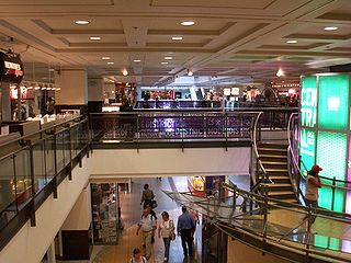
RÉSO, commonly referred to as the Underground City, is the name applied to a series of interconnected office towers, hotels, shopping centres, residential and commercial complexes, convention halls, universities and performing arts venues that form the heart of Montreal's central business district, colloquially referred to as Downtown Montreal. The name refers to the underground connections between the buildings that compose the network, in addition to the network's complete integration with the city's entirely underground rapid transit system, the Montreal Metro. Moreover, the first iteration of the Underground City was developed out of the open pit at the southern entrance to the Mount Royal Tunnel, where Place Ville Marie and Central Station stand today.

<span class="mw-page-title-main">Notre Dame Island</span> Artificial island near Montreal, Quebec, Canada

Notre Dame Island is an artificial island in the Saint Lawrence River in Montreal, Quebec, Canada. It is immediately to the east of Saint Helen's Island and west of the Saint Lawrence Seaway and the city of Saint-Lambert on the south shore. Together with Saint Helen's Island, it makes up Parc Jean-Drapeau, which forms part of the Hochelaga Archipelago. To the southeast, the island is connected to the embankment separating the seaway and Lachine Rapids.

<span class="mw-page-title-main">Green Line (Montreal Metro)</span> Metro line in Montreal, Quebec, Canada

The Green Line, also known as Line 1, is one of the four lines of the Montreal Metro in Montreal, Quebec, Canada. The line runs through the commercial section of downtown Montreal underneath Boulevard de Maisonneuve, formerly Rue de Montigny. It runs mainly on a northeast-to-southwest axis with a connection to the Orange and Yellow Lines at Berri-UQAM, and with the Orange Line west of downtown at Lionel-Groulx.

<span class="mw-page-title-main">McGill station</span> Montreal Metro station

McGill station is a Montreal Metro station in the borough of Ville-Marie in the downtown core of Montreal, Quebec, Canada. It is operated by the Société de transport de Montréal (STM) and serves the Green Line. The station opened on October 14, 1966, as part of the original network of the Metro.

<span class="mw-page-title-main">Berri–UQAM station</span> Montreal Metro station in the borough of Ville-Marie

Berri–UQAM station is a Montreal Metro station in the borough of Ville-Marie, in Montreal, Quebec, Canada. It is operated by the Société de transport de Montréal (STM) and is the system's central station. This station is served by the Green, Orange, and Yellow lines. It is located in the Quartier Latin.

<span class="mw-page-title-main">Orange Line (Montreal Metro)</span> Montreal Metro subway line

The Orange Line, also known as Line 2, is the longest and first-planned of the four subway lines of the Montreal Metro in Montreal, Quebec, Canada. It formed part of the initial network, and was extended from 1980 to 1986. On April 28, 2007, three new stations in Laval opened making it the second line to leave Montreal Island.

<span class="mw-page-title-main">Blue Line (Montreal Metro)</span> Rapid transit line in Montreal, Canada

The Blue Line, also known as Line 5, is one of the four lines of the Montreal Metro in Montreal, Quebec, Canada. It was the fourth to be built, notwithstanding its alternate official name of "Line 5", as Line 3 was planned but never built. Unlike the other three routes, the east–west Blue Line does not serve the city's main Metro junction at Berri-UQAM.

<span class="mw-page-title-main">Radisson station</span> Montreal Metro station

Radisson station is a Montreal Metro station in the borough of Mercier–Hochelaga-Maisonneuve in Montreal, Quebec, Canada. It is operated by the Société de transport de Montréal (STM) and serves the Green Line. It is in the district of Saint-Jean-de-Dieu. It opened on June 6, 1976, as part of the extension of the Green Line to Honoré-Beaugrand station.

<span class="mw-page-title-main">Lionel-Groulx station</span> Montreal Metro station

Lionel-Groulx station is a Montreal Metro station in the borough of Le Sud-Ouest in Montreal, Quebec, Canada. It is operated by the Société de transport de Montréal (STM) and is a transfer station between the Green Line and Orange Line, with cross-platform interchange available. It is located in the Saint-Henri area, along Atwater Avenue on that area's eastern border with Little Burgundy. If transfers between lines are included, the station is one of the busiest on the Metro. It first opened in 1978.

<span class="mw-page-title-main">Sherbrooke station</span> Montreal Metro station

Sherbrooke station is a Montreal Metro station in the borough of Le Plateau-Mont-Royal in Montreal, Quebec, Canada. It is operated by the Société de transport de Montréal (STM) and serves the Orange Line. This station, near downtown, opened on October 14, 1966, as part of the original network of the Metro.

<span class="mw-page-title-main">Jean-Drapeau station</span> Montreal Metro station

Jean-Drapeau station is a Montreal Metro station in Montreal, Quebec, Canada. It is operated by the Société de transport de Montréal (STM) and serves the Yellow Line. It is situated on the Saint Helen's Island in the Saint Lawrence River.

<span class="mw-page-title-main">Longueuil–Université-de-Sherbrooke station</span> Montreal Metro station

Longueuil station, officially Longueuil–Université-de-Sherbrooke station, is a Montreal Metro station in Longueuil, Quebec, Canada. It is operated by the Société de transport de Montréal (STM) and is the southern terminus of the Yellow Line. It is connected to a campus of Université de Sherbrooke, as well as the largest bus station in Greater Montreal, Terminus Longueuil.

<span class="mw-page-title-main">Ville-Marie, Montreal</span> Borough of Montreal in Quebec, Canada

Ville-Marie is the name of a borough (arrondissement) in the centre of Montreal, Quebec. The borough is named after Fort Ville-Marie, the French settlement that would later become Montreal, which was located within the present-day borough. Old Montreal is a National Historic Site of Canada.

<span class="mw-page-title-main">Réseau de transport de Longueuil</span> Public transit system in Longueuil, Quebec

Réseau de transport de Longueuil (RTL) is a public transit system in the city of Longueuil, Quebec, Canada, and nearby communities on the South Shore of Montreal. The RTL had an annual ridership of 34,447,686 in 2013.

<span class="mw-page-title-main">Saint Denis Street</span>

Saint Denis Street is a major north–south thoroughfare in Montreal, Quebec.

<span class="mw-page-title-main">Downtown Montreal</span> Neighbourhood, central business district of Montreal in Quebec, Canada

Downtown Montreal is the central business district of Montreal, Quebec, Canada.

<span class="mw-page-title-main">Montreal Metro</span> Metro system in Montreal, Quebec

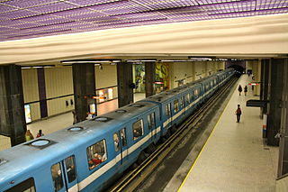
The Montreal Metro is a rubber-tired underground rapid transit system serving Greater Montreal, Quebec, Canada. The metro, operated by the Société de transport de Montréal (STM), was inaugurated on October 14, 1966, during the tenure of Mayor Jean Drapeau.

<span class="mw-page-title-main">Montréal-Sud</span>

Montreal-South was a suburb of Montreal located on the south shore of the St. Lawrence River founded in 1906. Montréal-Sud was created from land of the Saint-Antoine-de-Longueuil parish. Originally a village in its first five years, Montréal-Sud gained the status of city in 1911.

Jean Dumontier was a Canadian-Quebecois architect and artist. He is best known for having designed the Montreal Metro stations Jean-Drapeau and Longueuil-Université-de-Sherbrooke. He was also the first architect of the subway to have himself created the works of art for the stations of his own design, those being the four concrete walls of the dock of the station Jean-Drapeau.

References

  1. 1 2 3 4 5 6 "Au printemps 1967, on inaugurait la nouvelle ligne jaune du métro de Montréal" [Archives In the spring of 1967, the new yellow line of the Montreal metro was inaugurated]. Radio-Canada (in Canadian French). 2022-03-30. Retrieved 2023-08-16.
  2. 1 2 "Line 4 - Yellow - metrodemontreal.com". metrodemontreal.com. Retrieved 2023-08-16.
  3. "Métro history". Société de transport de Montréal. Retrieved October 25, 2016.
  4. "Au printemps 1967, on inaugurait la nouvelle ligne jaune du métro de Montréal". Radio-Canada (in Canadian French). 2022-03-30. Retrieved 2023-08-16.
  5. Magder, Jason (13 Oct 2016). "The métro at 50: Building the network". Montreal Gazette . When the city won the rights to host the 1967 World's Fair, executive committee chairman Lucien Saulnier spearheaded the idea to add a métro line to Île-Ste-Hélène and Longueuil on the South Shore. Hence the fourth line. Gérard Gascon, an engineer on the project, recalled that the Yellow Line was planned in one night. Saulnier called him one night in 1963 to ask whether it would be feasible to build the subway to the island, according to the book Métro: Design in Motion by John Martins-Manteiga (Dominion Modern, 2011) "I told him, 'We'll look at it.' Saulnier snapped back, 'Can you make it fast? I'm leaving for the airport at 7 tomorrow morning to ask permission of Quebec. We want to make sure it's possible, and how much it will cost. Can you give me an answer tonight?'"
  6. Banter, Bill (29 March 1963). "'Dazzling' future viewed for Saint Helen's Fair site". Montreal Gazette. p. 1. Extension of the Berri St subway line to the South Shore, with stations on Saint Helen's Island
  7. Negru, Myer (7 August 1967). "Extensions For Subway Approved". Montreal Gazette. p. 3.
  8. 1 2 Negru, Myer (3 August 1967). "City to seek $49 million for extensions to Subway". Montreal Gazette. p. 1. A branch line 14,000 feet long from the east-west route at St. Denis and Demontigny Sts. to Longueuil, in the vicinity of the Jacques Cartier Bridge. with stations on St. Helen's Island and on the projected "Notre Dame" Island to be created alongside the St. Lawrence Seaway dyke. Estimated cost - $17,000,000.
  9. 1 2 3 Negru, Myer (16 May 1964). "City Hall orders Longueuil subway". Montreal Gazette . p. 3.
  10. "Métro history". Société de transport de Montréal. Retrieved 2023-08-17. In the end, line 3 would be eliminated in favour of an entirely new line (4 - yellow) running under the St. Lawrence River to service the site of the 1967 World Fair.
  11. "Le 14 octobre 1966, le public a enfin accès au métro!" [On October 14, 1966, the public finally has access to the metro!] (in French). Societé de transport de Montréal. Archived from the original on 20 July 2012. Retrieved 7 September 2012.
  12. Hayes, Bob (28 April 1967). "Montreal's New Metro - A Trouble-Free Way". Montreal Gazette. pp. A4.
  13. "Jean-Drapeau (Jean Dumontier)". Société de transport de Montréal. Retrieved 2022-09-20.
  14. "Histoire - Campus de Longueuil - Université de Sherbrooke" [History - Longueuil Campus - University of Sherbrooke]. www.usherbrooke.ca. Retrieved 2023-08-16. 20 mars 1991 Inauguration des locaux occupés par l'UdeS au Complexe Saint-Charles, près du pont Jacques-Cartier et du métro Longueuil, marquant le début de la présence physique de l'institution à Longueuil.[March 20, 1991 Inauguration of the premises occupied by the UdeS at the Complexe Saint-Charles, near the Jacques-Cartier bridge and the Longueuil metro station, marking the beginning of the physical presence of the institution in Longueuil.]
  15. "Un pas important de franchi dans la planification intégrée des grands projets de transport collectif sur la Rive-Sud de Montréal" [An important step taken in the integrated planning of major public transportation projects on the South Shore of Montreal]. Gouvernement du Québec (in French). 24 Nov 2019. Retrieved 2023-08-16. La ligne jaune du métro permet de transporter 40 % des usagers du transport collectif voyageant entre la Rive-Sud et l'île de Montréal pendant la période de pointe du matin. Cette ligne compte une seule station sur la Rive-Sud, soit le terminus Longueuil-Université-de-Sherbrooke.[The yellow metro line transports 40% of public transit users traveling between the South Shore and the Island of Montreal during the morning rush period. This line has only one station on the South Shore, the Longueuil-Université-de-Sherbrooke terminus.]
  16. "Berri-UQAM". Société de transport de Montréal. Retrieved 2023-06-20. The name of the station was Berri-De Montigny from 1966 to 1987.
  17. "Jean Drapeau". Société de transport de Montréal. Retrieved 2022-09-20. The name of this station was Île-Sainte-Hélène from 1967 to 2000.
  18. "Les membres du conseil d'administration de la STM avaient approuvé ce changement en novembre 2002, répondant ainsi favorablement à la" [The members of the STM board of directors approved this change in November 2002, thus responding favorably to the]. Société de transport de Montréal (in French). 26 September 2003. Retrieved 2023-06-20. Les dirigeants de la Société de transport de Montréal et de l'Université de Sherbrooke ont officialisé aujourd'hui le changement de nom de la station de métro Longueuil en celui de Longueuil –Université-de-Sherbrooke.[The leaders of the Société de transport de Montréal and the University of Sherbrooke today formalized the change of name of the Longueuil metro station to Longueuil –Université-de-Sherbrooke.]
  19. "Longueuil-Université-de-Sherbrooke (zone B)". Société de transport de Montréal. Retrieved 2023-06-20. The name of this station was Longueuil from 1967 to 2002.
  20. "First accessible station on the Yellow line". Société de transport de Montréal. 22 November 2019. Retrieved 2022-09-20.
  21. "Berri-UQAM". Société de transport de Montréal. Retrieved 2022-09-20.
  22. "Quebec pushes ahead with Metro extension". CBC News. Sep 16, 2009. Retrieved 16 Aug 2023.
  23. "Railway Gazette: Montreal's 2020 vision". Railway Gazette International . Retrieved 2 January 2012.
  24. "The future of public transit: Major projects". Vision 2020. Agence métropolitaine de transport. Archived from the original on 2 November 2012. Retrieved 7 September 2012.
  25. "Le prolongement de la ligne 4 du métro dans Longueuil" [The extension of metro line 4 in Longueuil] (in French). Réseau de transport de Longueuil. Archived from the original on 20 January 2012. Retrieved 7 September 2012.
  26. "Quebec government open to yellow line metro extension in Longueuil". CTV News Montreal. 2018-11-06. Retrieved 2023-08-16.
  27. Lau, Rachel (20 April 2016). "Montreal Metro yellow line extension not happening". Global News. Retrieved 2023-08-16.
  28. "Caisse de dépôt subsidiary to study transit plan for South Shore". Montreal Gazette. 20 Oct 2020. Retrieved 16 Aug 2023. The mandate from the provincial government to CDPQ Infra includes establishing electrically powered public transit along Taschereau Blvd. as well as the extension of the métro's Yellow Line deeper into Longueuil.
  29. "Project office set up for métro extension, REM link on South Shore". Montreal Gazette. 24 Nov 2019. Retrieved 16 Aug 2023.
  30. O'Malley, Olivia (27 Feb 2020). "Montreal's south shore looks to get a new transit system". Global News. Retrieved 2023-08-24.
  31. Bisson, Bruno (2013-05-30). "Prolongement du métro de Montréal: la ligne jaune (Longueuil)" [Extension of the Montreal metro: the yellow line (Longueuil)]. La Presse (in Canadian French). Retrieved 2023-08-17. «Le transfert des voyageurs sur les lignes 1 (verte) et 2 (orange) en direction du centre-ville apportera une surcharge au niveau des quais à la station Berri-UQAM. Le service donné en ce moment sur ces deux lignes sera insuffisant pour éviter l'entassement des voyageurs sur les quais ainsi que les problématiques d'embarquement vers le centre-ville. Le prolongement de la ligne 4 vers le sud n'est donc pas exploitable», dans l'état actuel des choses. Pour résoudre ce problème, la STM propose de prolonger la ligne 4 de deux stations après Berri-UQAM, pour rejoindre l'actuelle station McGill sur la ligne verte.[“The transfer of travelers on lines 1 (green) and 2 (orange) towards the city center will cause an overload on the platforms at Berri-UQAM station. The service currently provided on these two lines will be insufficient to avoid crowding of travelers on the platforms as well as problems with boarding towards the city center. The extension of line 4 towards the south is therefore not usable”, in the current state of things. To resolve this problem, the STM is proposing to extend line 4 by two stations after Berri-UQAM, to reach the current McGill station on the green line.]
  32. "Deux nouvelles stations en vue" [Two new stations in sight]. 18 April 2007. Archived from the original on 21 April 2008. Retrieved 16 Aug 2023. L'AMT envisage également, à plus long terme, d'améliorer le tracé de la ligne jaune entre Longueuil et Berri-UQAM. Le tracé serait prolongé jusqu'à la station McGill afin de soulager la ligne verte.[The AMT is also considering, in the longer term, improving the route of the yellow line between Longueuil and Berri-UQAM. The route would be extended to McGill station in order to relieve the green line.]
  33. Jadah, Ty (7 Sep 2018). "Québec Solidaire promises to add 38 more metro stations if elected". dailyhive.com. Retrieved 2023-08-17.
  34. 1 2 "Line 4 - Yellow". Société de transport de Montréal. Retrieved 2023-08-19.