Ville-Marie, Montreal

Last updated
Ville-Marie
Mcgill college gdp.jpg
A view of McGill College Avenue in December, looking north. The Mount Royal Cross is visible in the background.
Logovillemarie.png
Carte localisation Montreal - Ville-Marie.svg
Location of Ville-Marie on the Island of Montreal.
(Grey areas indicate demerged municipalities).
Country Canada
Province Quebec
Region Montreal
EstablishedJanuary 1, 2002
Electoral Districts
Federal

Ville-Marie—Le Sud-Ouest—Île-des-Sœurs
Laurier—Sainte-Marie
Outremont
Provincial Westmount–Saint-Louis
Sainte-Marie–Saint-Jacques
Hochelaga-Maisonneuve
Saint-Henri–Sainte-Anne
Government
  TypeBorough
   Mayor Valérie Plante
  Federal MP(s) Marc Miller (LIB)
Steven Guilbeault (LIB)
Rachel Bendayan (LIB)
  Quebec MNA(s) Jennifer Maccarone (PLQ)
Manon Massé (QS)
Alexandre Leduc (QS)
Dominique Anglade (PLQ)
Area
  Total16.5 km2 (6.4 sq mi)
Population
 (2016) [4]
  Total89,170
  Density5,397.7/km2 (13,980/sq mi)
  Change (2011–2016)
Increase2.svg6.1%
  Dwellings
51,430
Time zone UTC-5 (EST)
  Summer (DST) UTC-4 (EDT)
Postal code(s)
Area code(s) (514) and (438)
Access Routes [6]
Quebec Autoroute 10.svg A-10
Qc134.svg R-134
Qc136.svg R-136
Qc138.svg R-138
Qc335.svg R-335
Website www.ville.montreal.qc.ca/villemarie

Ville-Marie is the name of a borough ( arrondissement ) in the centre of Montreal, Quebec. The borough is named after Fort Ville-Marie, the French settlement that would later become Montreal (now Old Montreal), which was located within the present-day borough. Old Montreal is a National Historic Site of Canada.

Contents

The borough comprises all of downtown Montreal, including the Quartier des spectacles; Old Montreal and the Old Port; the Centre-Sud area; most of Mount Royal Park as well as Saint Helen's Island and Île Notre-Dame.

In 2016, it had a population of 89,170 and an area of 16.5 square kilometres (6.4 sq mi). [4]

Geography

It is bordered by the city of Westmount (along Atwater Avenue) to the west and the boroughs of Le Sud-Ouest (along the Autoroute Ville-Marie, Guy and Notre-Dame streets, and the Bonaventure Autoroute) to the southwest, Mercier–Hochelaga-Maisonneuve (along the CP rail lines) to the east, Le Plateau-Mont-Royal (along Sherbrooke, University streets, and Pine and Park avenues) to the northeast, and Outremont and Côte-des-Neiges—Notre-Dame-de-Grâce (along the border of Mount Royal Park) to the north. It is bounded on the south by the Saint Lawrence River.

Government

Municipal

DistrictPositionName Party
 Borough mayor
(as mayor of Montreal)
Valérie Plante   Projet Montréal
Peter-McGillCity councillor Serge Sasseville   Ensemble Montréal
Saint-JacquesCity councillor Robert Beaudry   Projet Montréal
Sainte-MarieCity councillor Sophie Mauzerolle   Projet Montréal
 Borough councillors
(appointed by the mayor
from Montreal City Council)
Vicki Grondin
  Projet Montréal
Alia Hassan-Cournol
  Projet Montréal

As of 2009, the office of borough mayor, rather than being elected by the borough's citizens, is held ex officio by the mayor of Montreal. Also, two of the members of the borough council are city councillors from other boroughs, chosen by the mayor.

Rather than a dedicated borough hall, the borough's offices and council chambers are located in the Place Dupuis office tower at 800 De Maisonneuve Boulevard East.

This governing structure is due to the unique status of Ville-Marie as the centre of Montreal.

Federal and Provincial

The borough is divided among the following federal ridings:

It is divided among the following provincial electoral districts:

Demographics

Historical populations [4]
YearPop.±%
1966110,988    
197193,735−15.5%
197677,409−17.4%
198170,669−8.7%
198669,159−2.1%
199168,894−0.4%
1996 71,788+4.2%
2001 74,832+4.2%
2006 78,876+5.4%
2011 84,013+6.5%
2016 89,170+6.1%
Home language (2016)
LanguagePopulationPercentage (%)
French 43,64554%
English 21,68027%
Other languages16,04520%
Mother tongue (2016)
LanguagePopulationPercentage (%)
French 41,81550%
English 13,20516%
Other languages29,03034%
Visible Minorities (2016)
EthnicityPopulationPercentage (%)
Not a visible minority55,17563.7%
Visible minorities 31,38036.3%

Neighbourhoods

Ville-Marie includes the city's downtown, the historical district of Old Montreal, Le Quartier Chinois, the Gay Village, the Latin Quarter, the recently gentrified Quartier international and Cité Multimédia as well as the Quartier des Spectacles which is newly developed. Other neighbourhoods of interest in the borough include the affluent Golden Square Mile and Îlot-Trafalgar-Gleneagles at the foot of Mount Royal and the Shaughnessy Village/Quartier Concordia area home to thousands of students at Concordia University. The borough also comprises most of Mount Royal Park, Cité du Havre, Saint Helen's Island, and Île Notre-Dame.

Transportation

Montreal's interurban rail and bus terminals, and its two commuter rail terminals (Central Station, Lucien-L'Allier and the Downtown Terminus) are in the borough. It is served by the Orange, Green, and Yellow Lines of the Montreal Metro. The Metro's central station, Berri-UQAM (which is a terminus of the Yellow Line), and the Central Bus Station, are also located in Ville-Marie.

Two autoroutes serve the area: Autoroute Bonaventure and the partly underground Autoroute Ville-Marie. Two bridges — the Victoria Bridge and Jacques-Cartier Bridge  — provide access to the South Shore, while the Pont de la Concorde provides access to Saint Helen's Island and Notre Dame Island (Parc Jean-Drapeau). The Jacques-Cartier Bridge also provides access to Saint Helen's Island and Notre Dame Island.

Attractions

Many of Montreal's most famous attractions are situated in Ville-Marie. Most of its office towers, including 1000 de La Gauchetière, 1250 René-Lévesque, the Tour de la Bourse, Place Ville-Marie, the Sun Life Building, the Maison Radio-Canada, and many others are located here.

Three of Montreal's four universities McGill, Concordia, and UQAM  — are located in Ville-Marie, as are three of its four basilicas  Mary, Queen of the World Cathedral, Notre-Dame Basilica, and St. Patrick's Basilica. Cultural infrastructure includes Grande Bibliothèque du Québec, Place des Arts, the Montreal Museum of Fine Arts, the Quartier des spectacles, the Montreal Science Centre, Pointe-à-Callière Museum, Musée Grévin Montreal, and numerous other important venues.

Sports complexes include the Bell Centre, home of the Montreal Canadiens; the Percival Molson Stadium, home of the Montreal Alouettes; and the Circuit Gilles Villeneuve on Île Notre-Dame, site of the Canadian Grand Prix.

Hospitals include the Centre hospitalier de l'Université de Montréal (CHUM) megahospital, opened in 2017, as well as the Montreal General Hospital and Hôpital Notre-Dame.

Major parks and recreation areas include Mount Royal and its park, Parc Jean-Drapeau (the site of Expo 67), Dorchester Square and Place du Canada, and the Old Port.

The Montreal Public Libraries Network operates the Frontenac and Père-Ambroise libraries in the eastern part of the borough.

Economy

As Ville-Marie contains Montreal's central business district, numerous companies are headquartered or have major regional offices in the borough, including Bombardier Aerospace. [7] The International Civil Aviation Organization and the International Air Transport Association are also located in this borough.

Education

The Commission scolaire de Montréal (CSDM) operates French-language public schools. [8]

Elementary

Specialized

The English Montreal School Board (EMSB) operates English-language schools. [9]

Elementary

High school

See also

Related Research Articles

<span class="mw-page-title-main">Outremont, Quebec</span> Borough of Montreal in Quebec, Canada

Outremont is an affluent residential borough (arrondissement) of the city of Montreal, Quebec, Canada. It consists entirely of the former city on the Island of Montreal in southwestern Quebec. The neighbourhood is inhabited largely by Francophones, and is also home to a Hasidic Jewish community. Since the 1950s, Outremont has been mostly residential.

<span class="mw-page-title-main">Notre-Dame-de-Grâce</span> Neighbourhood in Montreal, Quebec, Canada

Notre-Dame-de-Grâce, also nicknamed NDG, is a residential neighbourhood of Montreal in the city's West End, with a population of 166,520 (2016). An independent municipality until annexed by the City of Montreal in 1910, NDG is today one half of the borough of Côte-des-Neiges–Notre-Dame-de-Grâce. It comprises two wards, Loyola to the west and Notre-Dame-de-Grâce to the east. NDG is bordered by four independent enclaves; its eastern border is shared with the City of Westmount, Quebec, to the north and west it is bordered by the cities of Montreal West, Hampstead and Côte-Saint-Luc. NDG plays a pivotal role in serving as the commercial and cultural hub for Montreal's predominantly English-speaking West End, with Sherbrooke Street West running the length of the community as the main commercial artery. The community is roughly bounded by Claremont Avenue to the east, Côte-Saint-Luc Road to the north, Brock Avenue in the west, and Highway 20 and the Saint-Jacques Escarpment to the south.

<span class="mw-page-title-main">Hochelaga-Maisonneuve</span> Neighbourhood in Montreal, Quebec, Canada

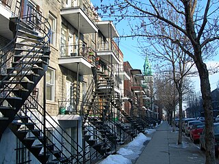
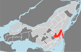
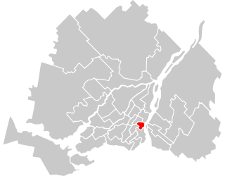
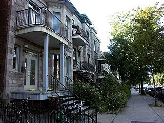
Hochelaga-Maisonneuve is a neighbourhood in Montreal, Canada, situated in the east end of the island, generally to the south of the city's Olympic Stadium and east of downtown.

<span class="mw-page-title-main">Laurier—Sainte-Marie</span> Federal electoral district in Quebec, Canada

Laurier—Sainte-Marie is a federal electoral district in Downtown Montreal, Quebec, Canada, that has been represented in the House of Commons of Canada since 1988. Its population in 2016 was 111,835.

<span class="mw-page-title-main">Outremont (electoral district)</span> Federal electoral district in Quebec, Canada

Outremont is a federal electoral district in Montreal, Quebec, Canada, that has been represented in the House of Commons of Canada since 1935. It was known as Outremont—Saint-Jean from 1947 to 1966. Its population in 2006 was 95,711. Its current Member of Parliament is Rachel Bendayan of the Liberal Party of Canada.

<span class="mw-page-title-main">Rosemont–La Petite-Patrie</span> Borough of Montreal in Quebec, Canada

Rosemont–La Petite-Patrie is a borough (arrondissement) in the city of Montreal, Quebec, Canada. It is located centre-east of the island.

<span class="mw-page-title-main">Urban agglomeration of Montreal</span> Administrative region in Quebec, Canada

Montréal is one of the administrative regions of the Canadian province of Quebec. It is also a territory equivalent to a regional county municipality (TE) and a census division (CD), for both of which its geographical code is 66. Prior to the merger of the municipalities in Region 06 in 2002, the administrative region was co-extensive with the Montreal Urban Community.

<span class="mw-page-title-main">Côte-des-Neiges–Notre-Dame-de-Grâce</span> Borough of Montreal in Quebec, Canada

Côte-des-Neiges–Notre-Dame-de-Grâce is a borough (arrondissement) of Montreal, Quebec, Canada. The borough was created following the 2002 municipal reorganization of Montreal. It comprises two main neighbourhoods, Côte-des-Neiges and Notre-Dame-de-Grâce, both former towns that were annexed by the city of Montreal in 1910.

<span class="mw-page-title-main">Mercier–Hochelaga-Maisonneuve</span> Borough of Montreal in Quebec, Canada

Mercier–Hochelaga-Maisonneuve is a borough of Montreal, Quebec, Canada located in the southeastern end of the island.

<span class="mw-page-title-main">Le Sud-Ouest</span> Borough of Montreal in Quebec, Canada

Le Sud-Ouest is a borough (arrondissement) of the city of Montreal, Quebec, Canada.

<span class="mw-page-title-main">Le Plateau-Mont-Royal</span> Borough of Montreal in Quebec, Canada

Le Plateau-Mont-Royal is a borough (arrondissement) of the city of Montreal, Quebec, Canada.

<span class="mw-page-title-main">Ahuntsic-Cartierville</span> Borough of Montreal in Quebec, Canada

Ahuntsic-Cartierville is a borough (arrondissement) of the city of Montreal, Quebec, Canada. The borough was created following the 2002 municipal reorganization of Montreal. It comprises two main neighbourhoods, Ahuntsic, a former village annexed to Montreal in 1910 and Cartierville, a town annexed to Montreal in 1916.

<span class="mw-page-title-main">L'Île-Bizard–Sainte-Geneviève</span> Borough of Montreal in Quebec, Canada

L'Île-Bizard–Sainte-Geneviève is a borough (arrondissement) of the city of Montreal.

<span class="mw-page-title-main">Downtown Montreal</span> Neighbourhood, central business district of Montreal in Quebec, Canada

Downtown Montreal is the central business district of Montreal, Quebec, Canada.

<span class="mw-page-title-main">Mercier, Montreal</span> Neighbourhood in Montreal, Quebec, Canada

Mercier denotes the eastern portion of the Mercier–Hochelaga-Maisonneuve borough of the city of Montreal, Quebec. It consists of two neighbourhoods Mercier-Ouest (Longue-Pointe) and Mercier-Est (Tétreaultville).

Outremont was a provincial electoral district in the city of Montreal in Quebec, Canada. It comprised all of the borough of Outremont and parts of the boroughs of Le Plateau-Mont-Royal, Côte-des-Neiges–Notre-Dame-de-Grâce and a very small part of Ville-Marie.

<span class="mw-page-title-main">Le Vieux-Longueuil</span> Borough of Longueuil in Quebec, Canada

Le Vieux-Longueuil is a borough in the city of Longueuil.

<span class="mw-page-title-main">Centre-Sud</span> Neighbourhood in Montreal, Quebec, Canada

The Centre-Sud is a neighbourhood located in the easternmost edge of the Ville-Marie borough of the city of Montreal.

<span class="mw-page-title-main">Commission scolaire Marguerite-Bourgeoys</span> Canadian school board

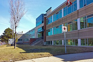
The Marguerite-Bourgeoys School Board was a French language public School Board on Montreal Island, Quebec, Canada. Its headquarters was in the Saint-Laurent borough of Montreal. Its education centre was in LaSalle, also in Montreal. It was named after Marguerite Bourgeoys (1620–1700), a French nun who helped start education infrastructure in the new colony.

References

  1. "Ministère des Affaires Municipales et Régions: Ville-Marie (Montreal)". gouv.qc.ca. Retrieved 13 April 2018.
  2. "History of Federal Ridings since 1867". www2.parl.gc.ca. Retrieved 13 April 2018.
  3. "Chief Electoral Officer of Québec - 40th General Election Riding Results: WESTMOUNT--SAINT-LOUIS". electionsquebec.qc.ca. Retrieved 13 April 2018.
    Chief Electoral Officer of Québec - 40th General Election Riding Results: SAINTE-MARIE--SAINT-JACQUES
    Chief Electoral Officer of Québec - 40th General Election Riding Results: HOCHELOGA-MAISONNEUVE
    Chief Electoral Officer of Québec - 40th General Election Riding Results: SAINT-HENRI--SAINTE-ANNE
  4. 1 2 3 4 "PROFIL SOCIODÉMOGRAPHIQUE - Recensement 2016 - Arrondissement de Ville-Marie" (PDF). Canada 2016 Census (in French). Ville de Montréal. 2012. Retrieved 14 February 2020.
  5. "Population totale en 2006 et en 2011 - Variation — Densité" (PDF). Canada 2011 Census (in French). Ville de Montréal. 2012. Retrieved 5 June 2012.
  6. "Québec 511 - Carte routière". www.quebec511.gouv.qc.ca. Gouvernement du Québec, Ministère des Transports, de la Mobilité durable et de l'Électrification des. Retrieved 13 April 2018.
  7. " Contacts." Bombardier Aerospace. Retrieved on September 14, 2009.
  8. "Trouver une école - Centre de services scolaire de Montréal".
  9. "Elementary School Search".

45°30′31″N73°33′46″W / 45.508556°N 73.562846°W / 45.508556; -73.562846