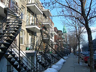
- Sainte-Marie, looking south towards the Jacques Cartier bridge
- The Maison Radio-Canada
- The historic JTI MacDonald factory on Ontario Street
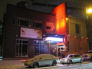
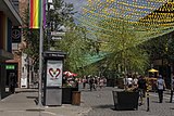
- The Gay Village
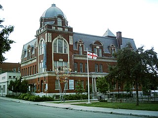
- The area around the Frontenac station
Centre-Sud | |
---|---|
Nicknames:
| |
Location of Centre-Sud in Montreal | |
Coordinates: 45°31′25″N73°33′07″W / 45.523565°N 73.55187°W | |
Country | Canada |
Province | Quebec |
City | Montreal |
Borough | Ville-Marie |
Postal code(s) | |
Area code(s) | 514 and 438 |
The Centre-Sud is a neighbourhood located in the easternmost edge of the Ville-Marie borough of the city of Montreal.
Home to Montreal's Gay Village and to the Sainte-Marie area, the Centre-Sud has long been seen as one of the city's most complex and troubled neighbourhoods. [1]
Having held a notorious reputation for poverty and prostitution for decades, particularly on Rue Ontario and Rue Dufresne, gentrification has changed the neighbourhood considerably in recent years. [1] [2] [3] [4]
During the era of New France, when the city was fortified, the populated area east of the walls came to be known as Faubourg Québec, a name that would live on as Faubourg à m'lasse. [5]
In 1782, the Molson family settled the area, purchasing a small brasserie from Irishman Thomas Loyd, which eventually developed into the brewery of the same name. [5]
Following the Lower Canada Rebellion, several patriots were hanged at the Pied-du-Courant Prison, a prison by the water. It ceased to be a prison in 1912, and the historic building was acquired by the SAQ in 1921, serving as its head office for a time. [5] [6]
Construction of the Jacques Cartier Bridge began in 1925, and was opened to traffic on May 14, 1930, becoming a prominent landmark in the neighbourhood. [7]
A large section of the neighbourhood known as Faubourg à m'lasse was torn down in 1963 to build the Maison Radio-Canada. [8]
An impoverished working class neighbourhood, the Centre-Sud began attracting members of the gay and lesbian community in the 1980s, due in part to affordability, after the migration of many gay businesses from other parts of the city. The area between St-Hubert and De Lorimier developed into the Gay Village by the 1990s as a result.
During the Quebec Biker War, the Rock Machine had their bunker in the Centre-Sud from 1992 to 1997, [10] which contributed to a bad reputation for poverty, [11] [12] organized crime and prostitution. [1] [2] [3] [9] [13] [14]
In 2001, a section of the neighbourhood known as l'îlot Huron, where the bunker and other illicit businesses thrived, was demolished to build a ramp to the Jacques Cartier Bridge and a large park, Parc des Faubourgs. [10] [15]
In recent years the neighbourhood has experienced significant gentrification and social change. [4] [16]
The Jacques Cartier Bridge and the Maison Radio-Canada are prominent in the skyline, as well as the Sûreté du Québec's headquarters, known as the Prison Parthenais. [17]
Notable features include the Molson Brewery, Gay Village, Hopital Notre-Dame, JTI MacDonald tobacco company and the historic Pied-du-Courant prison.
The Cente-Sud is well known for its street art and murals, notably of Québécois singers and actors, including Paul Buissonneau, Raymond Lévesque, Marjo, Robert Gravel, Pauline Julien, Plume Latraverse and Yvon Deschamps. [18]
Due to its poverty and proximity to downtown, a significant number of shelters, supervised injection sites [19] and resources for the homeless are located in the neighbourhood. This includes Dans la Rue for homeless youth, [20] and the Old Brewery Mission's Patricia Mackenzie Pavillion for homeless women. [21] Another shelter, Refuge des Jeunes, for young men 18-25, is also in the Centre-Sud. [22]
The city of Montreal operates the Bibliothèque Frontenac and Bibliothèque Père-Ambroise libraries respectively. [23] [24]
The city also operates several indoor pools and arenas including the Aréna Camillien-Houde, Centre Jean-Claude-Malépart and Piscine Quintal. [25] [26] [27]
The borough hall of Ville-Marie, is also located in the Centre-Sud, in the Place Dupuis shopping mall. [28]
The neighbourhood is bordered by the Saint Lawrence River to the south, Saint Hubert Street to the west, the Canadian Pacific rail line to the east and Sherbrooke Street to the north.
The Plateau is located to the north, Mercier-Hochelaga-Maisonneuve to the east and the Quartier Latin to the west.
Its main arteries running east to west are Rue Ontario, Boulevard De Maisonneuve, Rue Saint Catherine Est and Boulevard René Lévesque.
Major streets and avenues running north to south include Saint-Hubert, Papineau, De Lorimier, D'Iberville and Frontenac.
The neighbourhood is accessible by the following Montreal Metro stations, Frontenac, Papineau, Beaudry and Berri-UQAM (partly).
The following STM bus routes pass through the Centre-Sud;
Société de transport de Montréal | |||
---|---|---|---|
No. & Route Name | |||
10 De Lorimier | |||
14 Atateken | |||
15 Sainte-Catherine | |||
30 Saint-Denis/Saint-Hubert | |||
34 Sainte-Catherine | |||
45 Papineau | |||
85 Hochelaga | |||
94 D'Iberville | |||
125 Ontario | |||
185 Sherbrooke | |||
355 Papineau | |||
358 Sainte-Catherine | |||
445 Express Papineau |
The Commission scolaire de Montréal (CSDM) operates French-language public schools. [29]
The neighbourhood is part of the Montreal City Council district of Sainte-Marie and the federal riding of Laurier—Sainte-Marie. Provincially it’s part of Sainte-Marie–Saint-Jacques, with a small eastern corner in the Hochelaga-Maisonneuve riding, despite not being part of that neighbourhood.
The neighbourhood is the subject of Richard Beaulieu’s Chroniques du Centre-Sud, a 2014 graphic novel portraying the neighbourhood in the 1990s. [30]
The novel Ces Spectres Agités by Louis Hamelin is also set in the Centre-Sud. [37]
In 2013, a group of collaborative authors and photographers, released Hôtel Jolicoeur. A novel, in a scrapbook format, about a former motel and brothel located in the heart of the Centre-Sud, on the corner of Ontario and Papineau. [13] [38] [39]
Other novels set in the Centre-Sud include the autobiographies Pute de Rue (2003) by Roxanne Nadeau [9] and L’Enfer d’une fille de rue (2020) by Isa-Belle St-Sauveur. [14]
The 2003 documentary, Sexe de rue , focuses on prostitution in the neighbourhood.
Atach Tatuq released a song about the Centre-Sud in 2005 entitled Australie in their final album Deluxxx. [40]
It's also featured in Rue Ontario, a 2010 single by Bernard Adamus. [41]
Boucherville is a city in the Montérégie region in Quebec, Canada. It is a suburb of Montreal on the South shore of the Saint Lawrence River.
Hochelaga-Maisonneuve is a neighbourhood in Montreal, Canada, situated in the east end of the island, generally to the south of the city's Olympic Stadium and east of downtown.
Frontenac station is a Montreal Metro station in the borough of Ville-Marie in Montreal, Quebec, Canada. It is operated by the Société de transport de Montréal (STM) and serves the Green Line. It is located at 2570 Ontario Street East in the Sainte-Marie neighbourhood, part of the Centre-Sud.
"Faubourg" is an ancient French term historically equivalent to "fore-town". The earliest form is forsbourg, derived from Latin forīs, 'out of', and Vulgar Latin burgum, 'town' or 'fortress'. Traditionally, this name was given to an agglomeration forming around a throughway leading outwards from a city gate, and usually took the name of the same thoroughfare within the city. As cities were often located atop hills, their outlying communities were frequently lower down. Many faubourgs were located outside the city walls, and "suburbs" were further away from this location.
The Quartier Latin is an area in the Ville-Marie borough of Montreal, located east of the Quartier des Spectacles and west of the Centre-Sud and Village, centred around UQAM and lower Saint-Denis Street. It is known for its theatres, artistic atmosphere, cafés, and boutiques. It owes its name, a reference to the Quartier Latin in Paris, to the presence of the École Polytechnique de Montréal and the nascent Université de Montréal in the 1920s. In the 1940s the university moved out and headed for a new campus on the north slopes of Mount Royal, far from the downtown borough. In the late 1960s UQAM was born and established itself in the Ville-Marie borough, giving a modern underpinning to the name. A large junior college, the CEGEP du Vieux-Montreal also moved in at about the same period.
Ville-Marie is the name of a borough (arrondissement) in the centre of Montreal, Quebec. The borough is named after Fort Ville-Marie, the French settlement that would later become Montreal, which was located within the present-day borough. Old Montreal is a National Historic Site of Canada.
Mercier–Hochelaga-Maisonneuve is a borough of Montreal, Quebec, Canada located in the southeastern end of the island.
Le Sud-Ouest is a borough (arrondissement) of the city of Montreal, Quebec, Canada.
Ville-Émard is a neighbourhood located in the Sud-Ouest borough of Montreal, Quebec, Canada.
Le Vieux-Longueuil is a borough in the city of Longueuil.
Little Burgundy is a neighbourhood in the South West borough of the city of Montreal, Quebec, Canada.
Saint Antoine Street, formerly known as Craig Street, is a street located in Montreal, Quebec, Canada. It runs to the south of Downtown Montreal and north of Old Montreal and Griffintown and Saint-Henri. It crosses the Quartier international de Montréal. Between Atwater Avenue and Greene Avenue, the north side of the street is in Westmount.
The Sainte-Marie neighbourhood is located in the eastern edge of the Centre-Sud area, in the borough of Ville-Marie. The Jacques Cartier Bridge and Maison Radio-Canada overlook the neighbourhood.
Côte-Saint-Paul is a neighbourhood located in the Southwest Borough of Montreal, Quebec, Canada.
Côte-des-Neiges is a neighbourhood of Montreal, Quebec, Canada. It is located at the geographic centre of the Island of Montreal on the western slope of Mount Royal and is part of the borough of Côte-des-Neiges–Notre-Dame-de-Grâce.
Ontario Street is an east-west artery in Montreal, Quebec, Canada. It crosses the boroughs of Ville-Marie and Mercier–Hochelaga-Maisonneuve. In the latter borough, the street becomes a mix of residential and commercial and is known as Promenade Ontario.
The Red-Light District of Montreal, Quebec, Canada was formerly centred on the intersection of Saint Laurent Boulevard and Saint Catherine Street in the borough of Ville-Marie.
The Centre de services scolaire de l'Énergie is a francophone school service centre in the Mauricie region of Quebec, headquartered in Shawinigan.
Commission scolaire Marie-Victorin (CSMV) was a French-language, school board operating in the Province of Quebec, Canada and serving the municipality of Longueuil, Brossard and Saint-Lambert. The board's headquarters are in Longueuil.