Mount Royal, Quebec

Last updated

Mount Royal
Mont-Royal
Town of Mount Royal
Ville de Mont-Royal
Parc Connaught Park 22June2015 2.jpg
Connaught Park
Logo ville de Mont-Royal.png
Motto(s): 
Regium Donum
(Latin for "Royal gift")
Carte localisation Ile de Montreal - Mont-Royal.svg
Location on the Island of Montreal
Canada Southern Quebec location map.png
Red pog.svg
Mount Royal
Location in southern Quebec
Coordinates: 45°30′58″N73°38′35″W / 45.51611°N 73.64306°W / 45.51611; -73.64306 [3]
CountryCanada
Province Quebec
Region Montreal
RCM None
Founded1912
ConstitutedJanuary 1, 2006
Government
  MayorPeter J. Malouf
   Federal riding Mount Royal
   Prov. riding Mont-Royal–Outremont
Area
[4]
  Land7.55 km2 (2.92 sq mi)
Population
 (2021) [4]
  Total20,953
  Density2,776.7/km2 (7,192/sq mi)
  Pop. 2016-2021
Increase2.svg 3.3%
  Dwellings
8,192
Time zone UTC−5 (EST)
  Summer (DST) UTC−4 (EDT)
Postal code(s)
Area code(s) 514 and 438
Highways
Quebec Autoroute 15.svgTrans-Canada Highway shield.svg A-15 (TCH)
Quebec Autoroute 40.svgTrans-Canada Highway shield.svg A-40 (TCH)

Quebec Autoroute 520.svg A-520
Website www.ville.mont-royal.qc.ca/en OOjs UI icon edit-ltr-progressive.svg
[5]

Mount Royal (French : Mont-Royal, officially Town of Mount Royal, French : Ville de Mont-Royal, abbreviated TMR, French : VMR) is an affluent on-island suburban town located on the northwest side of the eponymous Mount Royal, northwest of Downtown Montreal, on the Island of Montreal in southwestern Quebec, Canada. It is completely surrounded by the city of Montreal. The population was 20,953 as of the 2021 Canadian census. [4] In 2008, most of the Town of Mount Royal was designated a National Historic Site of Canada, as a "[remarkable] synthesis of urban renewal movements of the early 20th century, reflecting the influence of the City Beautiful, Garden City and Garden Suburb movements". [6] The town celebrated its 100th anniversary in 2012.

Contents

History

Town of Mount Royal, or TMR, was founded in 1912. It was created at the initiative of the Canadian Northern Railway as a means of generating funds for the tunnel to be built under the mountain, which would connect the railway to downtown Montreal. [7] The town was designed by Frederick Todd, a planner who was heavily influenced by the likes of Sir Ebenezer Howard and incorporated many aspects of the Garden City Movement as well some elements of the earlier City Beautiful movement into his design. [8] The plan was to build a model city at the foot of Mount Royal. The company bought 4,800 acres (1,900 ha) of farmland, and then built a rail tunnel under Mount Royal connecting their land to downtown Montreal. The profits from the venture helped finance the development of Canadian Northern's transcontinental railroad, which eventually became a significant constituent of the Canadian National Railway system. The town was designed by Canadian Northern's chief engineer, Henry Wicksteed, based loosely on Washington, D.C.

The garden city's coat of arms is composed of several significant elements: [9]

Plan of "Model City" and of the Mount Royal Tunnel CarteDuTunnelMontRoyal.jpg
Plan of "Model City" and of the Mount Royal Tunnel

One notable feature of the town is the naming of some of its streets, and also its occasionally idiosyncratic numbering system. Some streets which pass through the town may thus bear two names (in whichever language). For example, Jean Talon Street, a large east–west thoroughfare crossing Montreal for kilometres (miles), goes a few hundred metres (yards) through TMR under the name of Dresden Avenue, only to recover its Montreal name on the other side of the town. This situation has been recently addressed by putting the two names on the street signs. On these few hundred metres (yards), TMR uses a house civic numbering totally different from that of Montreal on either side. This sort of change in the numbering system also occurs on smaller streets shared by both Montreal and TMR (for example, Trenton, Lockhart and Brookfield avenues, where the TMR numbering system decreases from East to West, only to jump from 2 to 2400 on the few metres (yards) of the street that still belong to Montreal.

In the beginning, the Town was a small farming community, known for its melons. The Daoust family farm grew the celebrated Montreal melon, also called the Montreal nutmeg melon. Green-fleshed and uniquely flavourful, the melons weighed up to 9 or 11 kg (20 or 25 lb). So special was the Montreal melon that it was exported to New York, Chicago and Boston, where, in 1921, people paid as much as $1.50 a slice to taste it. Farming was abandoned over the years, with the gradual urbanization of the Town. [10]

On January 1, 2002, as part of the 2002–2006 municipal reorganization of Montreal, it was merged into Montreal and became a borough. However, after a change of government and a 2004 referendum, it was re-constituted as an independent town on January 1, 2006.

Geography

The former Mont-Royal station served many commuters to Downtown Montreal. Work is now underway to convert it to an REM station. TMRTrainStation.JPG
The former Mont-Royal station served many commuters to Downtown Montreal. Work is now underway to convert it to an REM station.

Two main thoroughfares, Laird Boulevard and Graham Boulevard, cut across the borough diagonally and meet at Connaught Park, a green space located in the centre. Mount Royal Train Station, a commuter train station on the Exo Deux-Montagnes line is located to the east of this park. This line is now undergoing construction to upgrade it for the new REM network. Trains going through the Mount Royal Tunnel link the station to downtown Montreal in eight minutes. Both boulevards end at Jean Talon Street and close to the highway.

TMR is surrounded on three sides by a highway, a fence and a rail line.

The highway is Metropolitan Boulevard, a major constituent of Autoroute 40. It was built as an elevated highway throughout, except when it passes through TMR (between Sainte Croix Avenue and L'Acadie Boulevard), since the Town council requested that it be built on the ground, in order to separate the town from the industrial area to the north.

A fence runs along the eastern border with Park Extension at L'Acadie Boulevard, a six lane thoroughfare. The stated purpose of the fence is to prevent children and house pets from running into the busy thoroughfare but some have contended that it was built to keep residents of the working-class Park Extension neighbourhood out of the town. [11]

The rail line is the last portion of Canadian Pacific's Adirondack subdivision. It originally ran through the northern part of the district of Côte-des-Neiges. However, when the town became part of Montreal on Jan 1, 2002, the part of Côte-des-Neiges north of rail line was incorporated into the Mount Royal borough. When the town demerged on Jan 1, 2006 this part, known as Glenmount, reverted to Côte-des-Neiges.

Demographics

Historical populations
YearPop.±%
1921160    
19312,174+1258.8%
19414,888+124.8%
195111,352+132.2%
195616,990+49.7%
196121,182+24.7%
196621,845+3.1%
197121,560−1.3%
197620,514−4.9%
198119,247−6.2%
198618,350−4.7%
199118,212−0.8%
1996 18,282+0.4%
2001 18,682+2.2%
2006 18,933+1.3%
2011 19,503+3.0%
2016 20,276+4.0%
2021 20,953+3.3%
Source: Statistics Canada

According to the Office québécois de la langue française, Mont-Royal has been officially recognized as a bilingual municipality [12] since 2005-11-02. [13]

In the 2021 Census of Population conducted by Statistics Canada, Mont-Royal had a population of 20,953 living in 7,732 of its 8,192 total private dwellings, a change of

Home language (2021) [15]
LanguagePopulationPercentage (%)
French 8,93043%
English 5,72028%
Other languages4,11020%
Mother tongue (2021) [15]
LanguagePopulationPercentage (%)
French 8,12039%
English 3,59517%
Other languages7,23535%
Visible Minorities (2021) [15]
EthnicityPopulationPercentage (%)
Not a visible minority14,00068%
Visible minorities 6,69532%

Government

Mont-Royal Town Hall Siedziba merostwa w Mont Royal.JPG
Mont-Royal Town Hall

Municipal council

Mayor Peter J. Malouf [16] was elected 7 November 2021, defeating former municipal councillor Michelle Setlakwe, the first mayoral election in 16 years. Voter Participation was 48.7%. Despite the COVID pandemic, 6,779 residents voted by mail or in person. [17]

In 2020, TMR was divided from six into eight electoral districts to reflect its growing population of 22,000 residents. [18] The Town mayor sits on the Agglomeration Council of Montreal. [19]

2021-25 Municipal Council (100% new slate of elected officials): [20]

Former mayors

The first mayor of the Town of Mount-Royal was Thomas S. Darling, elected in 1913. [22]

Rockland Road in Mount-Royal at dusk Rocklandtmr.jpg
Rockland Road in Mount-Royal at dusk

Federal and Provincial

The entire borough is located within the federal riding of Mount Royal, whose best-known MP for nearly 20 years was Pierre Trudeau, and within the smaller provincial electoral district of Mount Royal. The Mount Royal riding has been a Liberal stronghold since 1940.

The riding encompasses Côte St. Luc, Hampstead, Côte des Neiges and the Town of Mount Royal. [23] Since 2015, Mr. Anthony Housefather has served as Member of The House of Commons - Mount Royal [24]

Mount Royal shares its provincial territory with Outremont since 2018, [25] making it the Mont-Royal–Outremont provincial electoral district. Since October 2022, the riding is represented by Liberal Michelle Setlakwe that replaced the long time MP Pierre Arcand. [26] [27]

Education

The Commission scolaire Marguerite-Bourgeoys (CSMB) operates Francophone public schools. [28]

Secondary schools:

Primary schools:

The English Montreal School Board (EMSB) operates Anglophone public schools in the town.

The Town has its own library, Reginald J. P. Dawson Library, which is independent from the Montreal Library Network.

See also

Related Research Articles

<span class="mw-page-title-main">Mount Royal</span> Small mountain in Montreal, Quebec, Canada

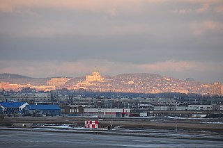
Mount Royal is a mountain in the city of Montreal, immediately west of Downtown Montreal, Quebec, Canada. The best-known hypothesis for the origin of the name Montreal is that the mountain is the namesake for the city.

<span class="mw-page-title-main">Hampstead, Quebec</span> City in Quebec, Canada

Hampstead is an on-island suburb of Montreal, Quebec, Canada. It is an independent municipality bordering the municipality of Côte Saint-Luc and the Côte-des-Neiges–Notre-Dame-de-Grâce borough of Montreal.

<span class="mw-page-title-main">Outremont, Quebec</span> Borough of Montreal in Quebec, Canada

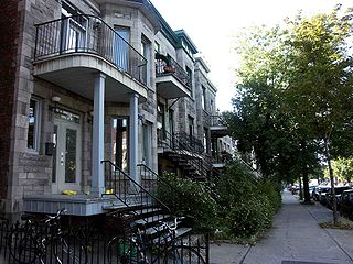
Outremont is an affluent residential borough (arrondissement) of the city of Montreal, Quebec, Canada. It consists entirely of the former city on the Island of Montreal in southwestern Quebec. The neighbourhood is inhabited largely by Francophones, and is also home to a Hasidic Jewish community. Since the 1950s, Outremont has been mostly residential.

<span class="mw-page-title-main">Notre-Dame-de-Grâce</span> Neighbourhood in Montreal, Quebec, Canada

Notre-Dame-de-Grâce, also nicknamed NDG, is a residential neighbourhood of Montreal in the city's West End, with a population of 166,520 (2016). An independent municipality until annexed by the City of Montreal in 1910, NDG is today one half of the borough of Côte-des-Neiges–Notre-Dame-de-Grâce. It comprises two wards, Loyola to the west and Notre-Dame-de-Grâce to the east. NDG is bordered by four independent enclaves; its eastern border is shared with the City of Westmount, Quebec, to the north and west it is bordered by the cities of Montreal West, Hampstead and Côte-Saint-Luc. NDG plays a pivotal role in serving as the commercial and cultural hub for Montreal's predominantly English-speaking West End, with Sherbrooke Street West running the length of the community as the main commercial artery. The community is roughly bounded by Claremont Avenue to the east, Côte-Saint-Luc Road to the north, Brock Avenue in the west, and Highway 20 and the Saint-Jacques Escarpment to the south.

<span class="mw-page-title-main">Outremont (electoral district)</span> Federal electoral district in Quebec, Canada

Outremont is a federal electoral district in Montreal, Quebec, Canada, that has been represented in the House of Commons of Canada since 1935. It was known as Outremont—Saint-Jean from 1947 to 1966. Its population in 2006 was 95,711. Its current Member of Parliament is Rachel Bendayan of the Liberal Party of Canada.

<span class="mw-page-title-main">Rosemont–La Petite-Patrie</span> Borough of Montreal in Quebec, Canada

Rosemont–La Petite-Patrie is a borough (arrondissement) in the city of Montreal, Quebec, Canada. It is located centre-east of the island.

Laurier—Outremont was a federal electoral district in Quebec, Canada, that was represented in the House of Commons of Canada from 1917 to 1935.

<span class="mw-page-title-main">Ville-Marie, Montreal</span> Borough of Montreal in Quebec, Canada

Ville-Marie is the name of a borough (arrondissement) in the centre of Montreal, Quebec. The borough is named after Fort Ville-Marie, the French settlement that would later become Montreal, which was located within the present-day borough. Old Montreal is a National Historic Site of Canada.

<span class="mw-page-title-main">Côte-des-Neiges–Notre-Dame-de-Grâce</span> Borough of Montreal in Quebec, Canada

Côte-des-Neiges–Notre-Dame-de-Grâce is a borough (arrondissement) of Montreal, Quebec, Canada. The borough was created following the 2002 municipal reorganization of Montreal. It comprises two main neighbourhoods, Côte-des-Neiges and Notre-Dame-de-Grâce, both former towns that were annexed by the city of Montreal in 1910.

<span class="mw-page-title-main">Le Plateau-Mont-Royal</span> Borough of Montreal in Quebec, Canada

Le Plateau-Mont-Royal is a borough (arrondissement) of the city of Montreal, Quebec, Canada.

<span class="mw-page-title-main">Saint-Laurent, Quebec</span> Borough of Montreal in Quebec, Canada

Saint-Laurent is a borough of the city of Montreal, Canada, located in the northern part of the island. Although it is no longer an independent city, it is still commonly known as Ville Saint-Laurent or by its initials, VSL.

<span class="mw-page-title-main">English Montreal School Board</span> Largest English-speaking Quebec school board

The English Montreal School Board is one of five public school boards on the island of Montreal.

<span class="mw-page-title-main">Centre de services scolaire Marguerite-Bourgeoys</span> Canadian school board

The Centre de services scolaire Marguerite-Bourgeoys is an autonomous school service centre on Montreal Island, Quebec, Canada, appointed by the Ministry of Education.

Mont-Royal is a provincial electoral district in Quebec, Canada that elects members to the National Assembly of Quebec. It is located within the island of Montreal, and comprises the city of Mount Royal and part of the Côte-des-Neiges–Notre-Dame-de-Grâce borough of Montreal.

Outremont was a provincial electoral district in the city of Montreal in Quebec, Canada. It comprised all of the borough of Outremont and parts of the boroughs of Le Plateau-Mont-Royal, Côte-des-Neiges–Notre-Dame-de-Grâce and a very small part of Ville-Marie.

Glenmount is a small residential neighbourhood located in the borough of Côte-des-Neiges–Notre-Dame-de-Grâce in the city of Montreal. Glenmount is bordered by the Town of Mount Royal (TMR) to the north, east and west, and by Côte-des-Neiges, marked by Jean-Talon Boulevard and the Canadian Pacific railway tracks to its south. There are about 1,300 people who live in the 75 acre neighbourhood.

<span class="mw-page-title-main">Côte-des-Neiges</span> Neighbourhood in Montreal, Quebec, Canada

Côte-des-Neiges is a neighbourhood of Montreal, Quebec, Canada. It is located at the geographic centre of the Island of Montreal on the western slope of Mount Royal and is part of the borough of Côte-des-Neiges–Notre-Dame-de-Grâce.

<span class="mw-page-title-main">Protestant School Board of Greater Montreal</span> Defunct confessional school district in Montreal, Quebec, Canada

The Protestant School Board of Greater Montreal was a Protestant and predominantly English-language school district in Montreal, Quebec, Canada which was founded in 1951 as a replacement for the Montreal Protestant Central Board, and ceased operations in 1998, with most of its assets transferred to the new English Montreal School Board. Quebec's Protestant school boards served all non-Catholics, so that the city's Jewish students generally attended schools operated by the PSBGM.

<span class="mw-page-title-main">Commission scolaire Marguerite-Bourgeoys</span> Canadian school board

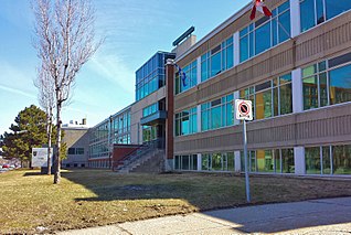
The Marguerite-Bourgeoys School Board was a French language public School Board on Montreal Island, Quebec, Canada. Its headquarters was in the Saint-Laurent borough of Montreal. Its education centre was in LaSalle, also in Montreal. It was named after Marguerite Bourgeoys (1620–1700), a French nun who helped start education infrastructure in the new colony.

<span class="mw-page-title-main">Côte-Sainte-Catherine Road</span> Street in Montreal, Canada

Côte-Sainte-Catherine Road is a street in Montreal, Quebec, Canada. It begins at the Décarie Expressway in Snowdon, part of the borough of Côte-des-Neiges–Notre-Dame-de-Grâce, and runs east and southeast along the periphery of Mount Royal to Park Avenue in the Plateau, terminating near Mount Royal Avenue. In between, it crosses Outremont completely and is one of the oldest streets in the borough, having been present at the time Outremont was incorporated in 1875. Outremont's borough hall is located on this street, as is Beaubien Park. Further west in Côte-des-Neiges, it houses the Jewish General Hospital, the CHU Sainte-Justine hospital, Collège Jean-de-Brébeuf, the Montreal Holocaust Museum, and the Segal Centre for Performing Arts.

References

  1. "List of the official municipalities of Québec". Gouvernement du Québec. 2012. Archived from the original on 5 February 2012. Retrieved 24 September 2012.
  2. "Ville de Mont-Royal - Town of Mount Royal (Homepage)". Town of Mount-Royal. 24 September 2012. Retrieved 24 September 2012.
  3. "Banque de noms de lieux du Québec: Reference number 388468". toponymie.gouv.qc.ca (in French). Commission de toponymie du Québec.
  4. 1 2 3 "Mont-Royal, Ville (V) Census Profile, 2021 Census of Population". www12.statcan.gc.ca. Government of Canada - Statistics Canada. 9 February 2022. Retrieved 20 June 2022.
  5. http://ville.montreal.qc.ca/pls/portal/docs/PAGE/MTL_STATS_FR/MEDIA/DOCUMENTS/PROFIL_SOCIOD%C9MO_MONT-ROYAL%202016.PDF [ bare URL PDF ]
  6. "Model City of Mount Royal". Directory of Designations of National Historic Significance of Canada. Parks Canada. Retrieved November 30, 2011.[ dead link ]
  7. McCann, L.D. (1996). "Planning and building the corporate suburb of Mount Royal, 1910-1925". Planning Perspectives. 11 (3): 259–301. Bibcode:1996PlPer..11..259M. doi:10.1080/026654396364871.
  8. Sewell, John. "The Shape of the City: Toronto Struggles with Modern Planning" page 52 University of Toronto Press Inc. 1993
  9. "History | A garden city".
  10. "Town of Mont Royal - Québec".
  11. Kristian Gravenor, "Segregation fence to live on." Montreal Mirror, November 8, 2001. Archived July 1, 2012, at the Wayback Machine
  12. "Montreal municipalities take action to keep bilingual status under Quebec's Bill 96 | Globalnews.ca". Global News. Retrieved 2023-04-20.
  13. "Organismes reconnus offrant des services dans une langue autre que le français". www.oqlf.gouv.qc.ca. 2022-12-19. Retrieved 2023-04-20.
  14. "Population and dwelling counts: Canada, provinces and territories, and census subdivisions (municipalities), Quebec". Statistics Canada. February 9, 2022. Retrieved August 29, 2022.
  15. 1 2 3 https://www12.statcan.gc.ca/census-recensement/2021/dp-pd/prof/details/page.cfm?LANG=E&GENDERlist=1&STATISTIClist=1,4&DGUIDlist=2021A00052466072&HEADERlist=0&SearchText=Mont-Royal
  16. "Peter J. Malouf | A garden city".
  17. "2021 Municipal Election: Preliminary Results Now Known | A garden city".
  18. "By-Law No. 1461 to Divide the Town's Territory into Eight Electoral Districts | A garden city".
  19. "Town Council | A garden city". www.ville.mont-royal.qc.ca. Retrieved 2018-06-03.
  20. "Town Council | A garden city".
  21. "Élection municipale du 7 novembre 2021".
  22. Kalbfleisch, John (2013). Le cadeau royal : histoire de la ville de Mont-Royal = The royal gift : a history of Town of Mount Royal. Town of Mount Royal, QC: Town of Mount Royal. p. 4. ISBN   9782980472732. OCLC   846793989.
  23. "Profile".
  24. "Profile".
  25. "La circonscription de Manon Massé sauvée, Maurice Richard honoré". La Presse (in French). 2017-03-02. Retrieved 2022-11-13.
  26. "Quebec election 2022 results: Mont-Royal-Outremont - Montreal | Globalnews.ca". Global News. Retrieved 2022-11-13.
  27. Lavoie, Laurent (8 May 2022). "Pierre Arcand se retire après 15 années chez les libéraux". Le Journal de Montréal. Retrieved 2022-11-13.
  28. "ÉCOLES ET CENTRES." Commission Scolaire Marguerite-Bourgeoys . Retrieved on December 7, 2014.
  29. Carlyle Elementary School
  30. École Dunrae Gardens School