Longueuil is a city in the province of Quebec, Canada. It is the seat of the Montérégie administrative region and the central city of the urban agglomeration of Longueuil. It sits on the south shore of the Saint Lawrence River directly across from Montreal. The population as of the Canada 2016 Census totalled 239,700, making it Montreal's second largest suburb, the fifth most populous city in Quebec and twentieth largest in Canada.

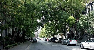
Notre-Dame-de-Grâce, also nicknamed NDG, is a residential neighbourhood of Montreal in the city's West End, with a population of 166,520 (2016). An independent municipality until annexed by the City of Montreal in 1910, NDG is today one half of the borough of Côte-des-Neiges–Notre-Dame-de-Grâce. It comprises two wards, Loyola to the west and Notre-Dame-de-Grâce to the east. NDG is bordered by four independent enclaves; its eastern border is shared with the City of Westmount, Quebec, to the north and west it is bordered by the cities of Montreal West, Hampstead and Côte-Saint-Luc. NDG plays a pivotal role in serving as the commercial and cultural hub for Montreal's predominantly English-speaking West End, with Sherbrooke Street West running the length of the community as the main commercial artery. The community is roughly bounded by Claremont Avenue to the east, Côte-Saint-Luc Road to the north, Brock Avenue in the west, and Highway 20 and the Saint-Jacques Escarpment to the south.
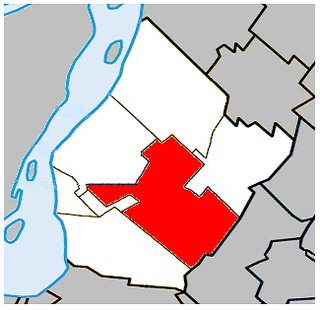
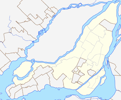
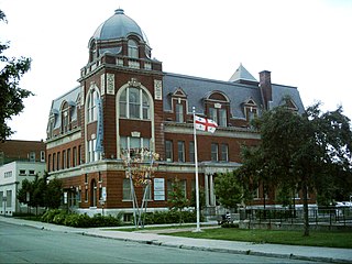
Saint-Hubert is a borough in the city of Longueuil, located in the Montérégie region of Quebec, Canada. It had been a separate city prior to January 1, 2002, when it along with several other neighbouring south shore municipalities were merged into Longueuil. Saint-Hubert had a population of 78,336 in 2006. The area of the borough is 65.98 km2 (25.48 sq mi). Longueuil's city hall is now located in Saint-Hubert. Saint-Hubert is located about 14 kilometres (8.7 mi) from downtown Montreal.

Boucherville is a city in the Montérégie region in Quebec, Canada. It is a suburb of Montreal on the South shore of the Saint Lawrence River.
Saint-Leonard is a borough (arrondissement) of Montreal, Quebec, Canada. Formerly a separate city, it was amalgamated into the city of Montreal in 2002. The former city was originally called Saint-Léonard de Port Maurice after Leonard of Port Maurice, an Italian saint. The borough is home to Montreal's Via Italia.

Ville-Marie is the name of a borough (arrondissement) in the centre of Montreal, Quebec. The borough is named after Fort Ville-Marie, the French settlement that would later become Montreal, which was located within the present-day borough. Old Montreal is a National Historic Site of Canada.

Villeray–Saint-Michel–Parc-Extension is a borough (arrondissement) in the city of Montreal, Quebec. It had a population of 143,853 according to the 2016 Census and a land area of 16.5 square kilometres (6.4 sq mi).

Chinatown in Montreal is located in the area of De la Gauchetière Street in Montreal. The neighbourhood contains many Asian restaurants, food markets, and convenience stores as well being home to many of Montreal's East Asian community centres, such as the Montreal Chinese Hospital and the Montreal Chinese Community and Cultural Centre.

Saint Laurent Boulevard, also known as Saint Lawrence Boulevard, is a major street in Montreal, Quebec, Canada. A commercial artery and cultural heritage site, the street runs north–south through the near-centre of city and is nicknamed The Main, which is the abbreviation for "Main Street".

Gay Village is a neighbourhood delineated by Saint Catherine Street East and Atateken Street in the Ville-Marie borough of Montreal, Quebec, Canada.

Le Plateau-Mont-Royal is a borough (arrondissement) of the city of Montreal, Quebec, Canada.

Ahuntsic-Cartierville is a borough (arrondissement) of the city of Montreal, Quebec, Canada. The borough was created following the 2002 municipal reorganization of Montreal. It comprises two main neighbourhoods, Ahuntsic, a former village annexed to Montreal in 1910 and Cartierville, a town annexed to Montreal in 1916.
Ville-Émard is a neighbourhood located in the Sud-Ouest borough of Montreal, Quebec, Canada.

Saint Denis Street is a major north–south thoroughfare in Montreal, Quebec.

Mile End is a neighbourhood and municipal electoral district in the city of Montreal, Quebec, Canada. It is part of the Plateau-Mont-Royal borough in terms of Montreal's municipal politics.
Milton Park, commonly known as the McGill Ghetto, is a neighbourhood in Montreal, Quebec, Canada. It is situated directly to the east of the McGill University campus in the borough of Plateau-Mont-Royal. It is named after the neighbourhood's two main streets, Milton Street and Park Avenue. Many McGill students live in this area, which is characterized by a mix of rowhouses and low- to mid-rise apartment buildings. The area is roughly bordered by University Street and the university campus to the west, Sherbrooke Street to the south, Pine Avenue to the north, and Park Avenue and the Lower Plateau neighborhood to the east, though McGill University considers this area to extend as far east as Saint Laurent Boulevard or just short of Saint-Louis Square.

Park Avenue is one of central Montreal's major north-south streets. It derives its name from Mount Royal Park, by which it runs. Between Mount Royal Avenue and Pine Avenue, the street separates the eastern side of the mountain park and the smaller Jeanne Mance Park.
Little Burgundy is a neighbourhood in the South West borough of the city of Montreal, Quebec, Canada.
Parc station, also known as Park Avenue station and formerly Jean-Talon station, is a historic railway station building in Montreal, Quebec, Canada. Its western end currently houses the Montreal Metro's Parc station, while businesses occupy the rest of the building. Although the main building no longer serves the railway, the Exo commuter rail Parc station is adjacent to it. It is located on Jean-Talon Street at the end of Park Avenue in the Park Extension neighbourhood of the borough of Villeray–Saint-Michel–Parc-Extension.