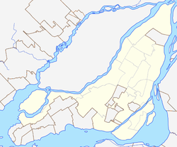
The Island of Montreal is a large island in southwestern Quebec, Canada, that is the site of a number of municipalities, including most of the city of Montreal, and is the most populous island in Canada. It is the main island of the Hochelaga Archipelago at the confluence of the Saint Lawrence and Ottawa rivers.

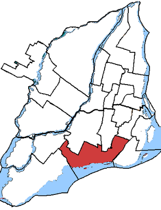
LaSalle—Émard was a federal electoral district in the Canadian province of Quebec that was represented in the House of Commons of Canada from 1988 to 2015. Its population in 2001 was 99,767. The MP from 1988 to 2008 was Paul Martin, who served as prime minister of Canada from 2003 to 2006. As part of redistribution begun in 2012 the riding is now known by its current name and boundaries of LaSalle—Émard—Verdun while the southwestern portion joined the new riding of Dorval—Lachine—LaSalle.

Saint-Lambert is a city in southwestern Quebec, Canada, located on the south shore of the St. Lawrence River, opposite Montreal. It is part of the Urban agglomeration of Longueuil of the Montérégie administrative region.
Notre-Dame-de-Grâce—Lachine was a federal electoral district in Quebec, Canada, that was represented in the House of Commons of Canada from 1997 to 2015. Its population in 2006 was 104,715.

LaSalle is the most southerly borough (arrondissement) of the city of Montreal, Quebec, Canada. It is located in the south-west portion of the Island of Montreal, along the Saint Lawrence River. Prior to 2002, it was a separate municipality that had been incorporated in 1912.

Brossard is a municipality in the Montérégie region of Quebec, Canada and is part of the Greater Montreal area. According to the 2021 census, Brossard's population was 91,525. It shares powers with the urban agglomeration of Longueuil and was a borough of the municipality of Longueuil from 2002 to 2006.

Verdun is a borough (arrondissement) of the city of Montreal, Quebec, located in the southeastern part of the island.

Griffintown is a historic neighbourhood of Montreal, Quebec, southwest of downtown. The area existed as a functional neighbourhood from the 1820s until the 1960s and was mainly populated by Irish immigrants and their descendants. Mostly depopulated since then, the neighbourhood has been undergoing redevelopment since the early 2010s.

Côte-des-Neiges–Notre-Dame-de-Grâce is a borough (arrondissement) of Montreal, Quebec, Canada. The borough was created following the 2002 municipal reorganization of Montreal. It comprises two main neighbourhoods, Côte-des-Neiges and Notre-Dame-de-Grâce, both former towns that were annexed by the city of Montreal in 1910.

Le Sud-Ouest is a borough (arrondissement) of the city of Montreal, Quebec, Canada.
Notre-Dame-de-Grâce was a federal electoral district in Quebec, Canada, that was represented in the House of Commons of Canada from 1949 to 1997.

Saint-Henri is a neighbourhood in southwestern Montreal, Quebec, Canada, in the borough of Le Sud-Ouest.

Lachine is a borough (arrondissement) within the city of Montreal on the Island of Montreal in southwestern Quebec, Canada.
Ville-Émard is a neighbourhood located in the Sud-Ouest borough of Montreal, Quebec, Canada.
Little Burgundy is a neighbourhood in the South West borough of the city of Montreal, Quebec, Canada.

Côte-Saint-Paul is a neighbourhood located in the Southwest Borough of Montreal, Quebec, Canada.
The timeline of Montreal history is a chronology of significant events in the history of Montreal, Canada's second-most populated city, with about 3.5 million residents in 2018, and the fourth-largest French-speaking city in the world.
LaSalle—Émard—Verdun is a federal electoral district in Montreal, Quebec. It was created by the 2012 federal electoral boundaries redistribution and was legally defined in the 2013 representation order. It came into effect upon the call of the 42nd Canadian federal election, scheduled for 19 October 2015. It was created out of parts of Jeanne-Le Ber (51%) and LaSalle—Émard (49%) plus a small section of territory between the Lachine Canal and the Le Sud-Ouest borough boundary taken from Westmount—Ville-Marie and an adjacent uninhabited section from Notre-Dame-de-Grâce—Lachine.

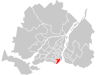
Notre-Dame-de-Grâce—Westmount is a federal electoral district in Quebec. It encompasses areas formerly included in the electoral districts of Notre-Dame-de-Grâce—Lachine (40%), Westmount—Ville-Marie (59%) and Outremont (1%).