Le Sud-Ouest

Last updated
Le Sud-Ouest
Mairie arrondissement Sud-Ouest.jpg
The borough hall of Le Sud-Ouest in Saint-Henri. In line with the area's industrial heritage, the building is a converted factory.
Logosudouest.png
Carte localisation Montreal - Le Sud-Ouest.svg
Location on the Island of Montreal.
(Dark grey areas indicate demerged municipalities).
Country Flag of Canada (Pantone).svg  Canada
Province Flag of Quebec.svg  Quebec
Region Montreal (06)
CreatedJanuary 1, 2002
Electoral Districts
Federal
LaSalle—Émard—Verdun
Ville-Marie—Le Sud-Ouest—Île-des-Sœurs
Provincial Saint-Henri–Sainte-Anne
Government
  TypeBorough
   Mayor Benoit Dorais (PM)
  Federal MP(s) David Lametti (LPC)
Marc Miller (LPC)
  Quebec MNA(s) Guillaume Cliche-Rivard (QS)
Area
[4]
  Total15.7 km2 (6.1 sq mi)
Population
 (2016) [4]
  Total78,151
  Density4,984.1/km2 (12,909/sq mi)
  Dwellings
40,900
Time zone UTC-5 (EST)
  Summer (DST) UTC-4 (EDT)
Postal code(s)
Area code(s) (514) and (438)
Access Routes [5]
Quebec Autoroute 10.svg A-10
Quebec Autoroute 15.svg A-15

Quebec Autoroute 20.svg A-20
Website https://montreal.ca/le-sud-ouest

Le Sud-Ouest (English: "The Southwest") is a borough ( arrondissement ) of the city of Montreal, Quebec, Canada.

Contents

Geography

A lock on the Lachine Canal between Petite-Bourgogne and Pointe-Saint-Charles. Lachine-canal.jpg
A lock on the Lachine Canal between Petite-Bourgogne and Pointe-Saint-Charles.

Le Sud-Ouest is an amalgam of several neighbourhoods with highly distinct histories and identities, mainly with working-class and industrial origins, grouped around the Lachine Canal. These include Saint-Henri, Little Burgundy, and Griffintown to the north of the canal, and Ville-Émard, Côte-Saint-Paul, and Pointe-Saint-Charles to the south.

Located southwest of downtown Montreal (hence the name), the borough is bordered to the northwest by Côte-des-Neiges—Notre-Dame-de-Grâce, to the northeast by the Ville-Marie borough, to the south by the borough of Verdun, to the west by the borough of LaSalle and the town of Montreal West, and to the north by the city of Westmount. The Saint Lawrence River is located upon part of its eastern edge.

History

See History of Saint-Henri, History of Little Burgundy, History of Ville-Émard, History of Côte-Saint-Paul, and History of Pointe-Saint-Charles.

Originally devoted to agriculture, the various municipalities and districts of the Sud-Ouest underwent rapid industrialization following the opening of the Lachine Canal in 1825, becoming the cradle of Canadian industry thanks to both the transportation and the water power offered by the canal. The Canadian National Railway and Grand Trunk Railway also came through Saint-Henri and Pointe-Saint-Charles. [6] The area became a stronghold of the working class, often in difficult conditions such as those described in Gabrielle Roy's The Tin Flute , set in Saint-Henri.

Monument to Irish immigrants in Pointe-Saint-Charles. Victoriatown Big Black Rock.jpg
Monument to Irish immigrants in Pointe-Saint-Charles.

The areas of the borough had highly specific identities. The western part of the borough - Saint-Henri, Ville-Émard, and Côte-Saint-Paul - were chiefly French Canadian, while Pointe-Saint-Charles and Griffintown were considered the seat of Irish culture in Montreal, with street names such as Hibernia and St. Patrick testifying to it. Starting in 1887, a large English-speaking Black community arose in Little Burgundy, attracted from the United States, other parts of Canada, and the Caribbean by jobs in the railways whose stations lay nearby; the area became famed for musical figures such as Oscar Peterson. [7]

The city of Montreal annexed the town of Saint-Henri in 1905, [8] Sainte-Cunégonde (Little Burgundy) in 1906, [9] and Côte-Saint-Paul and Ville-Émard in 1910. [10] [11]

However, with vessels constantly growing and finally exceeding the capacity of the canal, the coming of the St. Lawrence Seaway in 1956 and the closure of the Lachine Canal in 1970 put an end to the area's industrial prosperity. Population fell sharply and conditions became still more difficult. Projects such as the Décarie Expressway, Turcot Interchange, Bonaventure Expressway, and Expo '67 destroyed entire neighbourhoods, such as Goose Village and part of Côte-Saint-Paul. [10] However, community mobilization preserved the area's social fabric; [6] in particular, the Pointe-Saint-Charles Community Clinic became the model for the CLSC system now used throughout the province.

The reorganization of Montreal in 2002 following the municipal mergers saw the creation of the borough council system, and accordingly, the creation of the borough of Le Sud-Ouest. The borough council met in several temporary locations, including the Marie Uguay cultural centre in Ville-Émard, before the inauguration of the current borough hall in a repurposed factory in Saint-Henri. [12]

Today, Le Sud-Ouest is undergoing an economic and social renaissance, stimulated by the reclamation of the canal for recreation in 2002; businesses opened up and numerous factories were converted into lofts and condominiums. [6] This revival is bringing its own pressures, however, as gentrification increases property taxes and costs of living on the many low-income residents and puts pressure on the availability of low-income housing. The pending reconstruction of the Turcot Interchange and its impact on local residents is a major political issue in the borough.

Government

Municipal

The borough is divided into two municipal electoral districts:

The composition of the borough council remained unchanged following the 2017 municipal election, and consists of the following councillors:

DistrictPositionName Party
Borough mayor
City councillor
Benoit Dorais   Projet Montréal
Saint-Henri-Est–Petite-Bourgogne–
Pointe-Saint-Charles–Griffintown
City councillor Craig Sauvé   Projet Montréal
Borough councillor Tan Shan Li   Projet Montréal
Saint-Paul–Émard–Saint-Henri-OuestCity councillor Alain Vaillancourt   Projet Montréal
Borough councillor Anne-Marie Sigouin   Projet Montréal

Provincial

The bulk of the borough constitutes the provincial electoral district of Saint-Henri–Sainte-Anne; the industrial and railway area in the northeast is in the district of Notre-Dame-de-Grâce.

Federal

The borough is divided among the following federal ridings:

Demographics

Source: [4]

Historical populations
YearPop.±%
1966111,906    
197195,675−14.5%
197678,277−18.2%
198168,911−12.0%
198668,180−1.1%
199167,929−0.4%
1996 66,695−1.8%
2001 66,474−0.3%
2006 69,860+5.1%
2011 71,546+2.4%
2016 78,151+9.2%
2021 86,530+10.7%
Home language (2016)
LanguagePopulationPercentage (%)
French 42,62060%
English 18,43526%
Other languages10,44014%
Mother tongue (2016)
LanguagePopulationPercentage (%)
French 41,33056%
English 14,27019%
Other languages18,21025%
Visible Minorities (2016)
EthnicityPopulationPercentage (%)
Not a visible minority55,08072.1%
Visible minorities 21,30527.9%

Infrastructure

Place-Saint-Henri metro station. Place-Saint-Henri 32.jpg
Place-Saint-Henri metro station.

Transport

The borough is served by the green and orange lines of the Montreal Metro, including Place-Saint-Henri, Lionel-Groulx, Charlevoix, Angrignon, Georges-Vanier, Monk, and Jolicoeur stations.

The borough is traversed and partly delimited by Quebec Autoroutes 15 (Décarie Aut.) and 20 (Ville-Marie Aut.); Autoroute 10 (Bonaventure Aut.) also passes through it. The Montreal ends of the Champlain Bridge and Victoria Bridge lie in Le Sud-Ouest, as does the Turcot Interchange (autoroutes 15 and 20), Quebec's largest highway interchange. The CN rail lines exiting Central Station pass through the borough.

Major thoroughfares include Notre Dame St., Laurendeau St., St. Patrick St., La Vérendrye Blvd., De l'Église St., Monk Blvd., Centre St., Charlevoix St., Wellington St., Atwater Ave., and Guy St.

The Lachine Canal is crossed by the Boul. Monk, Rue Charlevoix, Rue des Seigneurs, and Rue Wellington bridges and by the Saint Rémi and Atwater tunnels.

Bicycle paths run along the Lachine Canal, through the Parc du Premier-Chemin-de-Fer and Rue Lionel-Groulx, and through Pointe-Saint-Charles. Pedestrian- and cyclist-only bridges across the canal are located at the Saint-Gabriel Locks, the Atwater Market, Gédéon de Catalogne Park (rue Beaudoin), and Rue de l'Église.

Culture and recreation

The two largest green spaces in the borough are the Lachine Canal and its recreational facilities (including the Lachine Canal National Historic Site of Canada), and Angrignon Park in Ville-Émard. Other important parks include Ignace Bourget Park (Ville-Émard), Sir George-Étienne Cartier Square and Saint-Henri Park (Saint-Henri), Vinet Park and Oscar Peterson Park (Little Burgundy), and Saint-Gabriel Park, Marguerite Bourgeoys Park, and Le Ber Park (Pointe-Saint-Charles).

The borough boasts numerous historic buildings, such as the Maison Saint-Gabriel (built in 1698), the former Negro Community Centre, the Atwater Market, Union United Church, Corona Theatre, the Atwater pumping station, the Saint-Henri fire hall, and the area's churches. In Saint-Henri, the Musée des ondes Emile Berliner tells the story of the radio and phonograph industry in the historic RCA Victor building.

The Musee des ondes Emile Berliner shows gramophones produced in Saint Henri Berliner Gramophone display.jpg
The Musée des ondes Emile Berliner shows gramophones produced in Saint Henri

The borough's community centres include the Centre Saint-Zotique, the Centre d'éducation populaire (CEDA), Tyndale-St. George's Community Centre, Maison Saint-Charles, and Centre Monseigneur-Pigeon. It is served by four libraries: Marie-Uguay, Saint-Henri, Georges-Vanier, and Saint-Charles. Sporting facilities include the Complexe récréatif Gadbois, one of the largest on the island, as well as the Piscine Émard, Piscine Saint-Henri, Centre sportif de la Petite-Bourgogne, and Piscine Saint-Charles.

Institutions

The territory of Le Sud-Ouest is served by the Centre de santé et des services sociaux du Sud-Ouest–Verdun, which operates the CLSCs Saint-Henri and Ville-Émard–Côte-Saint-Paul. [13] The Clinique communautaire Pointe-Saint-Charles, though it inspired the CLSC system and is the provider of CLSC services for Pointe-Saint-Charles, continues to operate independently of the CLSC system. The nearest hospitals are the Hôpital de Verdun, Hôpital de LaSalle and the McGill University Health Centre superhospital is immediately northwest of the borough.

Centre Sportif de la Petite-Bourgogne

The Little Burgundy Sports Center features a multitude of activities and spaces to accommodate a large audience. This large facility is very much involved in community life and contributes to the dynamism of Little Burgundy and the Southwest district. Its elegant and contemporary architecture makes it a true landmark in this part of Montreal.

Opened in 1997, this beautiful building was built at a cost of $8.6 million by neighborhood residents striving to overcome the lack of activities and sports facilities in the area.

Its funding was arranged by three parties: the federal and provincial governments have contributed $4 million and the City of Montreal invested $4.6 million.

During the opening, the mayor, Pierre Bourque, officially transferred the facility and equipment management to the Little Burgundy Sports Center Corporation, chaired at the time by Mrs. Léonie Charles.

Managed independently, the Little Burgundy Sport Center is represented by the board of directors and a management team that works in partnership with the South West district, City of Montreal.

Commerce

The Atwater Market, in the Saint-Henri neighbourhood. AtwaterMarket.jpg
The Atwater Market, in the Saint-Henri neighbourhood.

Major commercial streets include Boulevard Monk (Ville-Émard), Avenue de l'Église (Côte Saint-Paul), Rue du Centre (Pointe-Saint-Charles), and Rue Notre-Dame (Saint-Henri and Little Burgundy). Rue Notre-Dame in Little Burgundy is notable as a centre for antiques dealers.

The Atwater Market, is located beside the Lachine Canal. Joe Beef Restaurant is on Notre Dame Street West in Little Burgundy.

Education

Saint-Henri Library Bibliotheque Saint-Henri.jpg
Saint-Henri Library

The Commission scolaire de Montréal (CSDM) operates Francophone public schools.

The English Montreal School Board (EMSB) operates Anglophone public schools.

The Montreal Public Libraries Network operates four libraries: Réjean-Ducharme, [14] Marie-Uguay, Saint-Charles, and Saint-Henri. [15]

The borough is home to the École de technologie supérieure technical university.

Bibliothèque Réjean-Ducharme

This library, more than 100 years old, was the first French-language public library erected in Canada and is the oldest branch still in operation in the city. It was forced to close in 1918 after the First World War for budget reasons, but in 1947, thanks to the determination of Georges Vanier, it reopened as the Workman library.

See also

Related Research Articles

<span class="mw-page-title-main">Lachine Canal</span> Canal in southwestern Montreal, Canada

The Lachine Canal is a canal passing through the southwestern part of the Island of Montreal, Quebec, Canada, running 14.5 kilometres from the Old Port of Montreal to Lake Saint-Louis, through the boroughs of Lachine, Lasalle and Sud-Ouest.

<span class="mw-page-title-main">Jeanne-Le Ber</span> Electoral district in Quebec, Canada

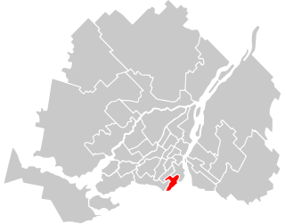
Jeanne-Le Ber was a federal electoral district in Quebec, Canada, that was represented in the House of Commons of Canada from 2004 to 2015. Its population in 2006 was 112,863. It was abolished for the 2015 election and dissolved into Ville-Marie—Le Sud-Ouest—Île-des-Sœurs and LaSalle—Émard—Verdun.

<span class="mw-page-title-main">LaSalle, Quebec</span> Borough of Montreal in Quebec, Canada

LaSalle is the most southerly borough (arrondissement) of the city of Montreal, Quebec, Canada. It is located in the south-west portion of the Island of Montreal, along the Saint Lawrence River. Prior to 2002, it was a separate municipality that had been incorporated in 1912.

<span class="mw-page-title-main">Verdun, Quebec</span> Borough of Montreal in Quebec, Canada

Verdun is a borough (arrondissement) of the city of Montreal, Quebec, located in the southeastern part of the island.

Pointe-Saint-Charles is a neighbourhood in the borough of Le Sud-Ouest in the city of Montreal, Quebec, Canada. Historically a working-class area, the creation of many new housing units, the recycling of industrial buildings into business incubators, lofts, and condos, the 2002 re-opening of the canal as a recreation and tourism area, the improvement of public spaces, and heritage enhancement have all helped transform the neighbourhood and attract new residents. Community groups continue to be pro-active in areas related to the fight against poverty and the improvement of living conditions.

<span class="mw-page-title-main">Griffintown</span> Neighbourhood in Montreal, Quebec, Canada

Griffintown is a historic neighbourhood of Montreal, Quebec, southwest of downtown. The area existed as a functional neighbourhood from the 1820s until the 1960s and was mainly populated by Irish immigrants and their descendants. Mostly depopulated since then, the neighbourhood has been undergoing redevelopment since the early 2010s.

<span class="mw-page-title-main">Ville-Marie, Montreal</span> Borough of Montreal in Quebec, Canada

Ville-Marie is the name of a borough (arrondissement) in the centre of Montreal, Quebec. The borough is named after Fort Ville-Marie, the French settlement that would later become Montreal, which was located within the present-day borough. Old Montreal is a National Historic Site of Canada.

<span class="mw-page-title-main">Saint-Henri, Montreal</span> Neighbourhood in Montreal, Quebec, Canada

Saint-Henri is a neighbourhood in southwestern Montreal, Quebec, Canada, in the borough of Le Sud-Ouest.

Ville-Émard is a neighbourhood located in the Sud-Ouest borough of Montreal, Quebec, Canada.

<span class="mw-page-title-main">Centre de services scolaire Marguerite-Bourgeoys</span> Canadian school board

The Centre de services scolaire Marguerite-Bourgeoys is an autonomous school service centre on Montreal Island, Quebec, Canada, appointed by the Ministry of Education.

<span class="mw-page-title-main">Little Burgundy</span> Neighbourhood in Montreal, Quebec, Canada

Little Burgundy is a neighbourhood in the South West borough of the city of Montreal, Quebec, Canada.

<span class="mw-page-title-main">Atwater Avenue</span>

Atwater Avenue is a major north–south street located in Montreal, Quebec, Canada. It links Doctor Penfield Avenue in the Ville-Marie borough to the north, and Henri Duhamel Street in the Verdun borough to the south. It is named for Edwin Atwater. The street runs through the Atwater Tunnel near the Atwater Market in Saint-Henri, before climbing and straddling the border of the city of Westmount.

The Canal de l'Aqueduc is an open-air aqueduct canal on the Island of Montreal in Quebec, Canada, serving part of the drinking water needs of the city of Montreal.

<span class="mw-page-title-main">Côte-Saint-Paul</span> Neighbourhood in Montreal, Quebec, Canada

Côte-Saint-Paul is a neighbourhood located in the Southwest Borough of Montreal, Quebec, Canada.

<span class="mw-page-title-main">Wellington Street (Montreal)</span> Thoroughfare in Montreal, Canada

Wellington Street is an north–south thoroughfare located in Montreal, Quebec, Canada. It starts at LaSalle Boulevard in the borough of Verdun, passes through Pointe-Saint-Charles and Griffintown in the borough of Le Sud-Ouest, and terminates at McGill Street in Old Montreal in the borough of Ville-Marie. Wellington Street spans 5.7 km (3.5 mi) in length.

<span class="mw-page-title-main">LaSalle—Émard—Verdun</span> Federal electoral district in Quebec, Canada

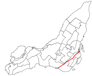
LaSalle—Émard—Verdun is a federal electoral district in Montreal, Quebec. It was created by the 2012 federal electoral boundaries redistribution and was legally defined in the 2013 representation order. It came into effect upon the call of the 42nd Canadian federal election, scheduled for 19 October 2015. It was created out of parts of Jeanne-Le Ber (51%) and LaSalle—Émard (49%) plus a small section of territory between the Lachine Canal and the Le Sud-Ouest borough boundary taken from Westmount—Ville-Marie and an adjacent uninhabited section from Notre-Dame-de-Grâce—Lachine.

<span class="mw-page-title-main">Saint Patrick Street</span> Thoroughfare in Montreal, Canada

Saint Patrick Street is a street in Montreal, Quebec, Canada.

References

  1. "Ministère des Affaires Municipales et Régions: Le Sud-Ouest (Montreal)". Archived from the original on 2013-01-06. Retrieved 2012-03-14.
  2. Parliament of Canada Federal Riding History: JEANNE-LE BER (Quebec)
    Parliament of Canada Federal Riding History: LASALLE--ÉMARD (Quebec)
  3. Chief Electoral Officer of Québec - 40th General Election Riding Results: SAINT-HENRI--SAINT-ANNE [ permanent dead link ]
    Chief Electoral Officer of Québec - 40th General Election Riding Results: NOTRE-DAME-DE-GRÂCE [ permanent dead link ]
  4. 1 2 3 Profile of the region ville.montreal.qc.ca
  5. "Carte routière officielle du Québec | Québec 511". www.quebec511.gouv.qc.ca.
  6. 1 2 3 "Histoire." Arrondissement du Sud-Ouest. Ville de Montréal. Accessed July 4, 2011.
  7. "Little Burgundy." McGill Faculty of Architecture. Accessed July 4, 2011.
  8. "Fiche du secteur: Square Sir-George-Étienne-Cartier." Grand répertoire du patrimoine bâti de Montréal. Accessed 4 July 2011.
  9. "Fiche du secteur: Coursol." Grand répertoire du patrimoine bâti de Montréal. Accessed 4 July 2011.
  10. 1 2 "Fiche du secteur: Côte-Saint-Paul." Grand répertoire du patrimoine bâti de Montréal. Accessed 4 July 2011.
  11. "L'Histoire du quartier en quelques mots." Archived 2008-11-14 at the Wayback Machine ville-emard.com. Accessed 4 July 2011.
  12. "Un peu d'histoire." Arrondissement du Sud-Ouest. Ville de Montréal. Accessed 4 July 2011.
  13. Centre de santé et des services sociaux du Sud-Ouest–Verdun. Accessed July 4, 2011.
  14. Montréal, Ville de. "Bibliothèque Réjean-Ducharme". montreal.ca. Retrieved 2023-11-28.
  15. "Les bibliothèques par arrondissement." Montreal Public Libraries Network. Retrieved on December 7, 2014.

45°27′21″N73°35′33″W / 45.45583°N 73.59250°W / 45.45583; -73.59250 (Le Sud-Ouest)