List of National Historic Sites of Canada in Niagara Region

Last updated

Map all coordinates using: OpenStreetMap  
Download coordinates as: KML

This is a list of National Historic Sites (French : Lieux historiques nationaux) in Niagara Region , Ontario. There are 26 National Historic Sites designated in Niagara, [1] of which nine are administered by Parks Canada (identified below by the beaver icon Beaver 1 (PSF)(retouched)(transparent).png ). [2]

Contents

Numerous National Historic Events also occurred in the Niagara Region, and are identified at places associated with them, using the same style of federal plaque which marks National Historic Sites. Several National Historic Persons are commemorated throughout the region in the same way. The markers do not indicate which designation—a Site, Event, or Person—a subject has been given.

National Historic Sites located elsewhere in Ontario are listed at National Historic Sites in Ontario.

This list uses the designation names as recognized by the national Historic Sites and Monuments Board, not necessarily the official or colloquial names of the sites.

National Historic Sites

Commons-logo.svg Media related to National Historic Sites of Canada in Ontario at Wikimedia Commons

SiteDate(s)DesignatedLocationDescriptionImage
Battle of Beaver Dams [3] [4] 1813 (battle)1921 Thorold
43°07′04″N79°11′08″W / 43.117776°N 79.185419°W / 43.117776; -79.185419 (Battle of Beaver Dams)
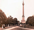
The site of a decisive British victory during the War of 1812, after heroine Laura Secord had earlier struck out on a long and difficult trek to warn the British of an impending American attack Laura Secord warns Fitzgibbons, 1813.jpg
Battle of Chippawa [5] [6] 1814 (battle)1921 Chippawa
43°03′08″N79°01′29″W / 43.052127°N 79.024720°W / 43.052127; -79.024720 (Battle of Chippawa)
The site of a battle that took place during the War of 1812 as a result of the last major American invasion of Canada Chippewa.jpg
Battle of Cook's Mills Beaver 1 (PSF)(retouched)(transparent).png [7] [8] 1814 (battle)1921 Cooks Mills
42°59′52″N79°10′30″W / 42.997895°N 79.174913°W / 42.997895; -79.174913 (Battle of Cook's Mills)
The site of the last engagement between U.S. and British/Canadian armies fought in Niagara, and second-last on Canadian soil during the War of 1812 Battle of Cook's Mills monument.jpg
Battle of Lundy's Lane [9] [10] 1814 (battle)1937 Niagara Falls
43°05′21″N79°05′44″W / 43.089152°N 79.095456°W / 43.089152; -79.095456 (Battle of Lundy's Lane)
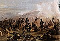
The site of a spontaneous confrontation between the British and American forces in which the British attacked American forces returning from the Battle of Chippawa; the six-hour-long battle was one of the bloodiest battles of the War of 1812 and marked the end of American offensive in Upper Canada Battle of Lundys Lane.jpg
Battlefield of Fort George Beaver 1 (PSF)(retouched)(transparent).png [11] [12] 1813 (battle)1921 Niagara-on-the-Lake
43°15.722′N79°05.071′W / 43.262033°N 79.084517°W / 43.262033; -79.084517 (Battlefield of Fort George)
The site of one of the fiercest battles of the War of 1812, in which the U.S. managed to gain a toehold on the Niagara Peninsula; distinct from nearby Fort George National Historic Site
Butler's Barracks Beaver 1 (PSF)(retouched)(transparent).png [13] [14] 1814–54 (completed)1963 Niagara-on-the-Lake
43°14′54″N79°04′27″W / 43.248370°N 79.074044°W / 43.248370; -79.074044 (Butler's Barracks)
A complex of five wooden buildings, built by the British after the War of 1812 and occupied as a military camp until the 1960s, representing 150 years of military history Butler's Barracks NOTL 1.JPG
Former L.J. Shickluna Service Station [15] [16] 1924 (c.) (completed)1995 Port Colborne
42°53′17″N79°15′04″W / 42.887941°N 79.251214°W / 42.887941; -79.251214 (Former L.J. Shickluna Service Station)
Early Spanish Colonial Revival-style service station; symbol of rapid post-World War I automobile culture Shickluna Service Station.jpg
Fort Drummond [17] [18] 1814 (completed)1928 Niagara-on-the-Lake
43°09′37″N79°03′08″W / 43.160147°N 79.052234°W / 43.160147; -79.052234 (Fort Drummond)
A redoubt and battery constructed during the War of 1812 to protect the main portage road from Chippawa to Queenston, named after Sir Gordon Drummond; some walls of the redoubt are still extant
Fort Erie [19] [20] 1808 (completion of third Fort Erie)1933 Fort Erie (town)
42°53′35.70″N78°55′25.74″W / 42.8932500°N 78.9238167°W / 42.8932500; -78.9238167 (Fort Erie)
The first British fort to be constructed as part of a network developed after the Seven Years' War in the western portion of the Province of Quebec (later Upper Canada); captured and destroyed in 1814 by invading American forces during the War of 1812, the remains of the fort were rebuilt by the Niagara Parks Commission in 1937–39 Fort Erie.JPG
Fort George Beaver 1 (PSF)(retouched)(transparent).png [21] [22] 1799 (completed), 1940 (reconstruction completed)1921 Niagara-on-the-Lake
43°15′03″N79°03′40″W / 43.25083°N 79.06111°W / 43.25083; -79.06111 (Fort George)
Reconstructed British fort that served as the principal fortification on the Niagara Peninsula during the War of 1812; distinct from the nearby Battlefield of Fort George National Historic Site Fort George NOTL 1.JPG
Fort Mississauga Beaver 1 (PSF)(retouched)(transparent).png [23] [24] 1814 (completed)1960 Niagara-on-the-Lake
43°15′42″N79°04′36″W / 43.26167°N 79.07667°W / 43.26167; -79.07667 (Fort Mississauga)
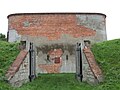
Located in a strategic position at the mouth of the Niagara River to protect the Canadian frontier and to counter Fort Niagara on the U.S. side, it is the only remaining fortification of its type (a square tower within a star-shaped earthwork) in Canada Fort Mississauga Entrance.jpg
Frenchman's Creek [25] [26] 1812 (battle)1921 Fort Erie
42°56′32″N78°55′35″W / 42.94227°N 78.92645°W / 42.94227; -78.92645 (Frenchman's Creek)
The battle of Frenchman’s Creek was a minor skirmish in the War of 1812, where British forces pushed an American advance parties back across the Niagara River; the failure of American troops contributed, in part, to the cancellation of the larger invasion planned for the Niagara peninsula at the end of 1812 100th Regiment of Foot c1812-1814.jpg
Mississauga Point Lighthouse Beaver 1 (PSF)(retouched)(transparent).png [27] [28] 1804 (completed), 1814 (demolished)1937 Niagara-on-the-Lake
43°15′41.92″N79°4′35.86″W / 43.2616444°N 79.0766278°W / 43.2616444; -79.0766278 (Mississauga Point Lighthouse)
The first lighthouse on the Great Lakes, constructed in 1804 by the military masons of the 49th Regiment of Foot, it was damaged in the Battle of Fort George in 1813, and demolished in 1814 when the British built Fort Mississauga on the site Mississauga Point Lighthouse site.jpg
Navy Island Beaver 1 (PSF)(retouched)(transparent).png [29] [30] 1761 (shipyard established)1921 Niagara Falls
43°3′23.07″N79°0′38.1″W / 43.0564083°N 79.010583°W / 43.0564083; -79.010583 (Navy Island)
Archaeological remains on an uninhabited island on the Ontario side of the Niagara River; during the 1760s, the island was home to the first British shipyard to serve the Upper Great Lakes and, during the Upper Canada Rebellion, the seat of William Lyon Mackenzie’s exiled government, the Republic of Canada Navy Island map.png
Niagara Apothecary [31] [32] 1820 (completed)1968 Niagara-on-the-Lake
43°15′18.25″N79°4′15.3″W / 43.2550694°N 79.070917°W / 43.2550694; -79.070917 (Niagara Apothecary)
A white, single-storey clapboard Georgian building on Niagara-on-the-Lake’s main commercial street, it served as an apothecary/pharmacy from approximately 1866 to 1964 and it is one of the very few remaining examples of an old apothecary shop Niagara-on-the-Lake Apotekary.jpg
Niagara District Court House [33] [34] 1847 (completed)1980 Niagara-on-the-Lake
43°15′18.25″N79°4′15.3″W / 43.2550694°N 79.070917°W / 43.2550694; -79.070917 (Niagara District Court House)
Designed by William Thomas in the Neoclassical style, it is an excellent example of a mid-19th-century multipurpose civic structure, originally containing the local court house, jail, market and town hall Niagara-on-the-Lake 02.jpg
Niagara-on-the-Lake [35] [36] 1815–59 (completed)2003 Niagara-on-the-Lake
43°15′18.02″N79°4′18.6″W / 43.2550056°N 79.071833°W / 43.2550056; -79.071833 (Niagara-on-the-Lake)
An early-19th-century Loyalist town located on the southern shore of Lake Ontario; the historic district covers 25 city blocks and contains the best collection of buildings in Canada from the period following the War of 1812 Niagara on the lake.jpg
Point Abino Light Tower [37] [38] 1918 (completed)1998 Crystal Beach
42°50′7.85″N79°5′42.64″W / 42.8355139°N 79.0951778°W / 42.8355139; -79.0951778 (Point Abino Light Tower)
A lighthouse situated at the eastern end of Lake Erie; intended to complement the summer homes nearby, it was more elaborately designed than most Canadian lighthouses, with a high level of its features still intact Pt Abino Lighthouse by Vicki McKay - 119.jpg
Queenston Heights Beaver 1 (PSF)(retouched)(transparent).png [39] [40] 1812 (battle)1968 Niagara-on-the-Lake
43°09′37″N79°03′08″W / 43.160147°N 79.052234°W / 43.160147; -79.052234 (Queenston Heights)
A treed promontory on the Niagara Escarpment, where the British repulsed an American invasion in the Battle of Queenston Heights in the War of 1812; site of Brock's Monument and a monument to Laura Secord Brock's Monument Queenston Heights circa 1920.jpg
Queenston-Chippawa Hydro-electric Plant [41] [42] 1925 (completed)1990 Niagara-on-the-Lake
43°8′45.47″N79°2′43.55″W / 43.1459639°N 79.0454306°W / 43.1459639; -79.0454306 (Queenston-Chippawa Hydro-electric Plant)
At the time of its completion, it was the first large-scale hydroelectric generation project in the world Adam Beck Complex.jpg
R. Nathaniel Dett British Methodist Episcopal Church [43] [44] 1836 (completed)1999 Niagara Falls
43°5′16.1″N79°5′14.95″W / 43.087806°N 79.0874861°W / 43.087806; -79.0874861 (R. Nathaniel Dett British Methodist Episcopal Church)
A British Methodist Episcopal Church chapel named after and associated with the formative years of composer Robert Nathaniel Dett; representative of early black settlement in the Niagara area and the church's role in assisting Underground Railroad refugees British Methodist Episcopal Church-NHS-Niagara Falls-Ontario-HPC9778-13333-20221117 (2).jpg
Ridgeway Battlefield Beaver 1 (PSF)(retouched)(transparent).png [45] [46] 1866 (battle)1921 Fort Erie
42°54′16″N79°02′30″W / 42.904349°N 79.041642°W / 42.904349; -79.041642 (Ridgeway Battlefield)
The site of the battlefield where the Queen’s Own Rifles, 13th Hamilton Battalion, and Caledonia and York Rifle Companies of Haldimand defended Canada against Fenian raiders from the United States Battle of Ridgeway.jpg
Salem Chapel, British Methodist Episcopal Church [47] [48] 1855 (completed)1999 St. Catharines
43°9′54.71″N79°14′24.16″W / 43.1651972°N 79.2400444°W / 43.1651972; -79.2400444 (Salem Chapel, British Methodist Episcopal Church)
A gable-fronted church representative of the auditory-hall design of Underground Railroad-related churches; an important centre of 19th-century abolitionist activity in Canada, associated with Harriet Tubman British Methodist Episcopal Church - Salem Chapel.jpg
Toronto Power Generating Station [49] [50] 1913 (completed)1983 Niagara Falls
43°4′19.45″N79°4′25.74″W / 43.0720694°N 79.0738167°W / 43.0720694; -79.0738167 (Toronto Power Generating Station)
A generating station to supply hydro-electric power to Toronto, it was the first wholly Canadian-owned hydro-electric facility at Niagara Falls; an elegant and unusual application of Beaux-Arts design to an industrial site in Canada Toronto Power Generating Station Niagara 2005.jpg
Willowbank [51] [52] 1836 (completed)2003 Niagara-on-the-Lake
43°10′04″N79°03′29″W / 43.16773°N 79.05796°W / 43.16773; -79.05796 (Willowbank)
A 5-hectare (12-acre) estate with a large 3+12-storey temple-fronted mansion; the landscaping and largely unchanged exterior architecture are symbolic of the fusion of Neoclassical architecture and the Picturesque ideal that characterized large country estates of Upper Canada in the early 19th century Willowbank back side.jpg
Vrooman's Battery [53] [54] 1812 (battle)1921 Niagara-on-the-Lake
43°10′41.76″N79°3′30.05″W / 43.1782667°N 79.0583472°W / 43.1782667; -79.0583472 (Vrooman's Battery)
An artillery battery that maintained a harassing fire on the American forces crossing the Niagara River during the Battle of Queenston Heights in the War of 1812; now consists of a mound on the riverbank

See also

Related Research Articles

<span class="mw-page-title-main">Niagara-on-the-Lake</span> Town in Ontario, Canada

Niagara-on-the-Lake is a town in Ontario, Canada. It is located on the Niagara Peninsula at the point where the Niagara River meets Lake Ontario, across the river from New York, United States. Niagara-on-the-Lake is in the Niagara Region of Ontario and is the only town in Canada that has a lord mayor. It has a population of 17,511 (2016).

<span class="mw-page-title-main">Battle of Lundy's Lane</span> War of 1812 battle

The Battle of Lundy's Lane, also known as the Battle of Niagara, was a battle fought on 25 July 1814, during the War of 1812, between an invading American army and a British and Canadian army near present-day Niagara Falls, Ontario. It was one of the bloodiest battles of the war, and one of the deadliest battles ever fought in Canada, with approximately 1,720 casualties including 258 killed.

<span class="mw-page-title-main">Old Fort Erie</span>

Old Fort Erie, also known as Fort Erie, or the Fort Erie National Historic Site of Canada, was the first British fort to be constructed as part of a network developed after the Seven Years' War was concluded by the Treaty of Paris (1763), at which time France ceded its territories east of the Mississippi River to Great Britain. The installation is located on the southern edge of what is now the Town of Fort Erie, Ontario, directly across the Niagara River from Buffalo, New York, United States.

<span class="mw-page-title-main">Queenston Heights</span>

The Queenston Heights is a geographical feature of the Niagara Escarpment immediately above the village of Queenston, Ontario, Canada. Its geography is a promontory formed where the escarpment is divided by the Niagara River. The promontory forms a cliff face of approximately 100 m.

<span class="mw-page-title-main">Queenston</span> Town in Ontario, Canada

Queenston is a compact rural community and unincorporated place 5 kilometres (3.1 mi) north of Niagara Falls in the Town of Niagara-on-the-Lake, Ontario, Canada. It is bordered by Highway 405 to the south and the Niagara River to the east; its location at the eponymous Queenston Heights on the Niagara Escarpment led to the establishment of the Queenston Quarry in the area. Across the river and the Canada–US border is the village of Lewiston, New York. The Lewiston-Queenston Bridge links the two communities. This village is at the point where the Niagara River began eroding the Niagara Escarpment. During the ensuing 12,000 years the Falls cut an 11 kilometres (6.8 mi) long gorge in the Escarpment southward to its present-day position.

Chippawa is a community located within the city of Niagara Falls, Ontario.

<span class="mw-page-title-main">National Historic Sites of Canada</span> Heritage registers in Canada

National Historic Sites of Canada are places that have been designated by the federal Minister of the Environment on the advice of the Historic Sites and Monuments Board of Canada (HSMBC), as being of national historic significance. Parks Canada, a federal agency, manages the National Historic Sites program. As of July 2021, there were 999 National Historic Sites, 172 of which are administered by Parks Canada; the remainder are administered or owned by other levels of government or private entities. The sites are located across all ten provinces and three territories, with two sites located in France.

<span class="mw-page-title-main">Fort George, Ontario</span> Historic site in Ontario, Canada

Fort George was a military fortification in Niagara-on-the-Lake, Ontario, Canada. The fort was used by the British Army, the Canadian militia, and the United States Armed Forces for a brief period. The fort was mostly destroyed during the War of 1812. The site of the fort has been a National Historic Site of Canada since 1921, and features a reconstruction of Fort George.

<span class="mw-page-title-main">Battle of Beaver Dams</span> War of 1812 battle

The Battle of Beaver Dams took place on 24 June 1813, during the War of 1812. A column of troops from the United States Army marched from Fort George and attempted to surprise a British outpost at Beaver Dams, billeting themselves overnight in the village of Queenston, Ontario. Laura Secord, a resident of Queenston, had earlier learned of the American plans and had struck out on a long and difficult trek to warn the British at Decou's stone house near present-day Brock University. When the Americans resumed their march, they were ambushed by Kahnawake and other native warriors and eventually surrendered to a small British detachment led by Lieutenant James FitzGibbon. About 500 U.S. troops, including their wounded commander, were taken prisoner.

<span class="mw-page-title-main">Battle of Chippawa</span> War of 1812 battle

The Battle of Chippawa, also known as the Battle of Chippewa, was a victory for the United States Army in the War of 1812, during its invasion on July 5, 1814, of the British Empire's colony of Upper Canada along the Niagara River. This battle and the subsequent Battle of Lundy's Lane demonstrated that trained American troops could hold their own against British regulars. The battlefield is preserved as a National Historic Site of Canada.

The Niagara Parks Commission, commonly shortened to Niagara Parks, is an agency of the Government of Ontario which maintains the Ontario shoreline of the Niagara River.

<span class="mw-page-title-main">Fort Mississauga</span>

Fort Mississauga National Historic Site is a fort on the shore of Lake Ontario, at the mouth of the Niagara River in Niagara-on-the-Lake, Ontario, Canada. The fort today consists of a box–shaped brick tower and historic star–shaped earthworks. The all–brick fort was built from 1814–1816 during the War of 1812, to replace nearby Fort George. It was built on a foundation of brick and stone salvaged from rubble left after retreating United States forces burned the nearby town of Newark in December, 1813. It would help in the defence of Upper Canada the following year, as part of a regional network that included Fort George, Navy Hall, and Butler's Barracks. However, the fort would not be completed until after the war.

Willowbank is a mansion in Queenston, Ontario, Canada.

References

  1. Ottawa, Directory of Designations of National Historic Significance of Canada
  2. Niagara Archived 2012-10-08 at the Wayback Machine , Queenston Archived 2012-10-08 at the Wayback Machine , Cook's Mills, Ridgeway - National Historic Sites of Canada - administered by Parks Canada
  3. Battle of Beaver Dams [ permanent dead link ], Directory of Designations of National Historic Significance of Canada
  4. Battle of Beaver Dams . Canadian Register of Historic Places .
  5. Battle of Chippawa [ permanent dead link ], Directory of Designations of National Historic Significance of Canada
  6. Battle of Chippawa . Canadian Register of Historic Places .
  7. , Directory of Designations of National Historic Significance of Canada
  8. Battle of Cook's Mills . Canadian Register of Historic Places .
  9. Battle of Lundy's Lane, Directory of Designations of National Historic Significance of Canada
  10. Battle of Lundy's Lane . Canadian Register of Historic Places .
  11. Battlefield of Fort George, Directory of Designations of National Historic Significance of Canada
  12. Battlefield of Fort George . Canadian Register of Historic Places .
  13. Butler's Barracks, Directory of Designations of National Historic Significance of Canada
  14. Butler's Barracks . Canadian Register of Historic Places .
  15. Former L.J. Shickluna Service Station, Directory of Designations of National Historic Significance of Canada
  16. Macfarlane, L.C. (Kate). "Gasoline Stations". The Canadian Encyclopedia . The Historica Dominion Institute . Retrieved 28 February 2011.
  17. Fort Drummond [ permanent dead link ], Directory of Designations of National Historic Significance of Canada
  18. Fort Drummond . Canadian Register of Historic Places .
  19. Fort Erie, Directory of Designations of National Historic Significance of Canada
  20. Fort Erie . Canadian Register of Historic Places .
  21. Fort George [ permanent dead link ], Directory of Designations of National Historic Significance of Canada
  22. Fort George . Canadian Register of Historic Places .
  23. Fort Mississauga [ permanent dead link ], Directory of Designations of National Historic Significance of Canada
  24. Fort Mississauga . Canadian Register of Historic Places .
  25. Frenchman's Creek [ permanent dead link ], Directory of Designations of National Historic Significance of Canada
  26. Frenchman's Creek . Canadian Register of Historic Places .
  27. Mississauga Point Lighthouse [ permanent dead link ], Directory of Designations of National Historic Significance of Canada
  28. Mississauga Point Lighthouse . Canadian Register of Historic Places .
  29. Navy Island, Directory of Designations of National Historic Significance of Canada
  30. Navy Island . Canadian Register of Historic Places .
  31. Niagara Apothecary, Directory of Designations of National Historic Significance of Canada
  32. Niagara Apothecary . Canadian Register of Historic Places .
  33. Niagara District Court House, Directory of Designations of National Historic Significance of Canada
  34. Niagara District Court House . Canadian Register of Historic Places .
  35. Niagara-on-the-Lake [ permanent dead link ], Directory of Designations of National Historic Significance of Canada
  36. Niagara-on-the-Lake . Canadian Register of Historic Places .
  37. Abino Light Tower, Directory of Designations of National Historic Significance of Canada
  38. Point Abino Light Tower . Canadian Register of Historic Places .
  39. Queenston Heights [ permanent dead link ], Directory of Designations of National Historic Significance of Canada
  40. Queenston Heights . Canadian Register of Historic Places .
  41. Queenston-Chippawa Hydro-electric Plant, Directory of Designations of National Historic Significance of Canada
  42. Queenston-Chippawa Hydro-electric Plant . Canadian Register of Historic Places .
  43. R. Nathaniel Dett British Methodist Episcopal Church, Directory of Designations of National Historic Significance of Canada
  44. Nathaniel Dett British Methodist Episcopal Church . Canadian Register of Historic Places .
  45. Ridgeway Battlefield [ permanent dead link ], Directory of Designations of National Historic Significance of Canada
  46. Ridgeway Battlefield . Canadian Register of Historic Places .
  47. Salem Chapel, British Methodist Episcopal Church, Directory of Designations of National Historic Significance of Canada
  48. Salem Chapel, British Methodist Episcopal Church . Canadian Register of Historic Places .
  49. Toronto Power Generating Station, Directory of Designations of National Historic Significance of Canada
  50. Toronto Power Generating Station . Canadian Register of Historic Places .
  51. Willowbank, Directory of Designations of National Historic Significance of Canada
  52. Willowbank . Canadian Register of Historic Places .
  53. Vrooman's Battery, Directory of Designations of National Historic Significance of Canada
  54. Vrooman's Battery . Canadian Register of Historic Places .