Related Research Articles

Drummond Township is a civil township of Chippewa County in the U.S. state of Michigan. The population was 973 at the 2020 census.

The Battle of Lundy's Lane, also known as the Battle of Niagara or contemporarily as the Battle of Bridgewater, was fought on 25 July 1814, during the War of 1812, between an invading American army and a British and Canadian army near present-day Niagara Falls, Ontario. It was one of the bloodiest battles of the war, and one of the deadliest battles fought in Canada, with approximately 1,720 casualties including 258 killed.
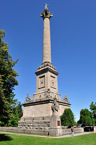
The Queenston Heights is a geographical feature of the Niagara Escarpment immediately above the village of Queenston, Ontario, Canada. Its geography is a promontory formed where the escarpment is divided by the Niagara River. The promontory forms a cliff face of approximately 100 m.
Fort Holmes is a fortified earthen redoubt located on the highest point of Mackinac Island. Originally built in 1814 by British forces during the War of 1812, the redoubt was improved by that army throughout the course of the war (1812–1814) to help defend the adjacent Fort Mackinac from a possible attack by the U.S. Army.
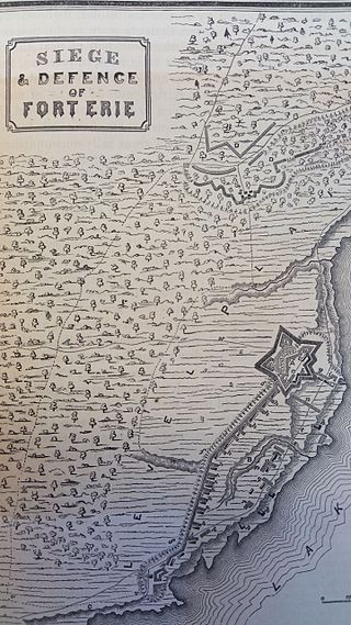
The Capture of Fort Erie by American forces in 1814 was a battle in the War of 1812 between the United Kingdom and the United States. The British garrison was outnumbered but surrendered prematurely, in the view of British commanders.

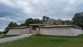
The siege of Fort Erie, also known as the Battle of Erie, from 4 August to 21 September 1814, was one of the last engagements of the War of 1812, between British and American forces. It took place during the Niagara campaign, and the Americans successfully defended Fort Erie against a British army. During the siege, the British suffered high casualties in a failed storming attempt; they also suffered casualties from sickness and exposure in their rough encampments. Unaware that the British were about to abandon the siege, the American garrison launched a sortie to destroy the British siege batteries, during which both sides again suffered high losses.
The Battle of Cook's Mills was the last engagement between U.S. and British armies in the Niagara, and the penultimate engagement on Canadian soil during the War of 1812. After a battle lasting less than an hour, American forces out-maneuvered the British column, and later destroyed all grain found in the mill.
USS Lady of the Lake was a small schooner in the United States Navy during the War of 1812. She was built by Henry Eckford of Sacketts Harbor, New York, during the summer and winter of 1812-13, launched 6 April 1813 and entered service 13 days later, Sailing Master Flinn in command.
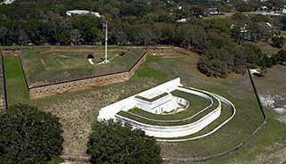
Fort Barrancas (1839) or Fort San Carlos de Barrancas is a United States military fort and National Historic Landmark in the former Warrington area of Pensacola, Florida, located physically within Naval Air Station Pensacola, which was developed later around it.

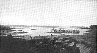
The Capture of Fort Niagara took place 18-19 December 1813 during the War of 1812 between Great Britain and the United States. The American garrison was taken by surprise, and the fort was captured in a night assault by a select force of British regular infantry.
Navy Island Royal Naval Shipyard was a Royal Navy yard in Ontario.

Fort St. Joseph is a former British outpost on the southernmost point of St. Joseph Island in Ontario, Canada, on Lake Huron. The fort consisted of a blockhouse, powder magazine, bakery building, Indian council house and storehouse surrounded by a palisade.

Butler's Barracks was the home of Loyalist military officer John Butler (1728–1796), in what was then Newark, Upper Canada; present day Niagara-on-the-Lake, Ontario. Butler is most famous for leading an irregular military unit known as Butler's Rangers on the northern frontier during the American Revolutionary War.
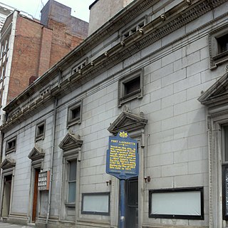
Fort Lafayette, later renamed Fort Fayette, (1792–1814) was an American fort in Pittsburgh, Pennsylvania, United States. It was constructed in June 1792 by Major General Anthony Wayne upon his commission to form the Legion of the United States.

Fort Billingsport, referred to as Fort Billings in some sources, was a Continental Army fort in Billingsport in Paulsboro, New Jersey in Gloucester County, New Jersey, during the American Revolutionary War. The site of the fort is now a public park of the same name, located at the Plains Terminal at the Port of Paulsboro between two oil refineries.
Boquet is an unincorporated community in Penn Township, Westmoreland County, Pennsylvania, United States.

Fort Clinton was a stone-and-earthworks fortification on an elevation within what is now Central Park in New York City. It was built in 1814 near the present line of 107th Street, slightly west of Fifth Avenue. According to maps of the time, Fort Clinton was the easternmost of a connected series of forts, connected to Nutter's Battery on the west by earthworks and a gatehouse over the Old Post Road at the bottom of McGowan's Pass. Fort Clinton and Nutter's Battery were commanded from a third fort at the top of the pass, Fort Fish, which had a sweeping view of Long Island Sound, northern Manhattan, and Westchester County. Fort Fish was across the road from Fort Clinton and connected to Nutter's Battery by another line of earthworks.
Fort Drummond, also known as Fort Colyer or Fort Collier, is a military fort located on the west end of Drummond Island on Whitney Bay, in the vicinity of De Tour Village, Michigan. It is the only known military and civilian site established by British forces on American soil following the War of 1812. It was listed on the National Register of Historic Places in 1969 and designated a Michigan State Historic Site in 1956.
Nicolls' Outpost was the smaller and more northern of two forts built by British Lt. Col. Edward Nicolls during the War of 1812. (The Americans referred to it as Fort Apalachicola. Built at the end of 1814, together with the larger "British post" or storage depot down the Apalachicola, it was "the northernmost post built by the British during their Gulf Coast Campaign". It was just below the Spanish Florida–Georgia border, where the Flint and Chattahoochee Rivers meet to form the Apalachicola, in River Landing Park in modern Chattahoochee, Florida. Even though what was built was smaller than the much larger British post down the Apalachicola, it was intended to be the base, presumably enlarged, for an English invasion of the United States, and British post was to have been its supply depot. The 1815 end of the War of 1812 aborted this project.
References
- ↑ Fort Drummond Archived 2008-07-31 at the Wayback Machine
- ↑ Guidebook to the historic sites of the War of 1812. p. 113
43°09′37″N79°03′08″W / 43.160147°N 79.052234°W
National Historic Sites of Canada by location | |
|---|---|
| Provinces | |
| Territories | |
| Other countries | |