Fort Drummond (Drummond Island, Michigan)

Last updated
Fort Drummond
Fort Drummond Illustration.jpg
Illustration of Fort Drummond
USA Michigan location map.svg
Red pog.svg
Usa edcp location map.svg
Red pog.svg
Fort Drummond (Drummond Island, Michigan)
Interactive map
LocationW end of Drummond Island, Drummond Island, Michigan
Coordinates 45°58′40″N83°51′40″W / 45.97778°N 83.86111°W / 45.97778; -83.86111
Area84.5 acres (34.2 ha)
Built1815
NRHP reference No. 69000069 [1]
Significant dates
Added to NRHPOctober 1, 1969
Designated MSHSNovember 27, 1956 [2]

Fort Drummond, also known as Fort Colyer or Fort Collier, is a military fort located on the west end of Drummond Island on Whitney Bay, in the vicinity of De Tour Village, Michigan. It is the only known military and civilian site established by British forces on American soil following the War of 1812. [2] It was listed on the National Register of Historic Places in 1969 [1] and designated a Michigan State Historic Site in 1956. [2]

Contents

History

Establishment

Map of Fort Drummond Site; created c. 1896 Fort Drummond Location.jpg
Map of Fort Drummond Site; created c. 1896
Whitney Bay, Site of Fort Drummond, c. 1959 photo Fort Drummond Site by Air.jpg
Whitney Bay, Site of Fort Drummond, c. 1959 photo

The Treaty of Ghent, signed in late 1814, required British troops to vacate the captured Fort Mackinac on Mackinac Island. [2] The terms of the treaty, however, did not reach the Fort Mackinac garrison until May 15, 1815. The instructions to the fort's commanding officer, Lieutenant Colonel Robert McDonall, were to vacate Fort Mackinac and re-establish a garrison within British territory but relatively close to Mackinac Island. [3] In particular, it was important that the new site be sufficiently close to the Straits of Mackinac that the British could continue to exert their considerable influence on the Native American peoples tribes and the fur trade in the upper Great Lakes region. [2] McDonall considered several sites in the area, and finally settled on a site on the west end [2] of the then-unnamed Drummond Island. [4] The transfer of stores and men to the new site was slow to accomplish, and it took McDonall's garrison until July 18, 1815, to completely empty Fort Mackinac, which was then turned over to American forces. [5]

Some of the forces under McDonall's command were mustered out in the latter part of 1815 and were shipped home, but by the time the transfer to Drummond Island was complete, the garrison consisted of some 350–400 people. These men were set to work constructing structures on Drummond Island, but due to lack of training, the progress was slow. [6] In addition, there was some uncertainty as to whether Drummond Island was actually a British or American possession, according to the Treaty of Ghent, so the British were somewhat reluctant to put a substantial fortification in place. [6] Eventually, buildings located on St. Joseph Island belonging to the North West Company were purchased, disassembled, and re-assembled in order to provide shelter for the coming winter. [7]

There was still some uncertainty as to the final disposition of Drummond Island, and thus the British government was reluctant to expend much manpower or materiel fortifying Fort Drummond. [8] Some few military structures were erected, but on the whole there was no real boundary between the military and civilian sections of the "fort". [2] In 1816, McDonall resigned his commission and was replaced by Lt. Col. Maule; in 1817 Maule was replaced by Major Thomas Howard and then by Major James Winnett. Through this period the military emplacement on Drummond Island remained substantially as it had been at the end of 1815. [8]

Abandonment

Winnett was relieved by Major Goff in June 1822. However, in 1822, it was determined that Drummond Island was actually part of the United States, per the Treaty of Ghent. Still, the British forces were in no hurry to leave Fort Drummond, and Goff was replaced in June 1824 by Lieutenant James J. Gaston, who was relieved in June 1827 by Lieutenant Thomas Carson. [9] In the interim, a suitable location for the relocation of the Fort Drummond troops was sought; finally a site in what is now Penetanguishene, on the southeast corner of Georgian Bay, was tentatively selected. [10]

By 1828, the United States government demanded that Fort Drummond be abandoned by the British, and they hurriedly did so, shipping troops and materiel to Penetanguishene. However, due to lack of shipping space, much food and personal belongings such as furniture were left behind by the departing British. American forces, led by Lieutenant T. Pierce Simonton, [10] took possession of the fort on November 14, 1828. [2] However, the US military did not occupy the fort. Some of the village houses remained occupied for at least the remainder of the winter, but it is not clear when the site was finally abandoned. At some point, what was likely a natural forest fire destroyed the remainder of the fort. [11]

Description

Chimney from Fort Drummond, c. 1959 photo Fort Drummond Chimney c1959.jpg
Chimney from Fort Drummond, c. 1959 photo

The settlement at Fort Drummond contained military structures as well as private houses. The settlement was centered around a parade ground fronting on the west side of the bay. Military barracks and commissary were located on the west side of the parade ground, and officer's quarters were haphazardly placed in the area. A "boulevard" ran along northward from the parade ground a good 2,000 feet (610 m), while a military road continued southward of the parade ground to the shore. [12] The section of land east of the boulevard, between the boulevard and the bay, was reserved for gardens, while houses were built on the west side of the boulevard. The boulevard was lined by a row of poplar trees on each side. [13]

Some of the houses were substantial, and a few were two stories. Other houses were "bark lodges," made of a pole framework covered with cedar. Kitchens for the houses were located some distance away, and much of the cooking and baking was done in a public bakery reserved for that purpose. [14]

The cemetery was located to the west of the fort, some ways up the ridge rising from the bay. The cemetery was platted at 100 by 150 feet (30 by 46 m), and enclosed by a cedar rail fence. [15] The cemetery likely holds around 300 people, many of the burials dating from the scurvy outbreak in the winter of 1815–6 and the smallpox outbreak of 1824. Many of the grave markers are now located in the Drummond Island Museum.

A lime quarry and kiln is located south of the town; this location was likely used to produce mortar for the chimneys. A saw mill was also located north of the town; this may or may not have been contemporaneous with Fort Drummond, but evidence of sawn logs in the fort buildings was confirmed. [12] Some of the islands in Whitney Bay were also used by the fort, with the fort surgeon living on one and another used for artillery target practice. [16]

As of 2012, the Fort Drummond site is private property, and the site is only viewable from the water. [16] At least one of the remaining chimneys has been incorporated into a cabin. [17] The Fort Drummond site contains 74 features, most of which are the remains of chimneys and structural platforms. There are also two wells, two wharves, and a cemetery. [2] Faint traces of foundations can still be seen. [17]

Related Research Articles

<span class="mw-page-title-main">Mackinac Island</span> Island in Michigan, United States

Mackinac Island is an island and resort area, covering 4.35 square miles (11.3 km2) in land area, in the U.S. state of Michigan. The name of the island in Odawa is Michilimackinac and "Mitchimakinak" in Ojibwemowin meaning "Great Turtle". It is located in Lake Huron, at the eastern end of the Straits of Mackinac, between the state's Upper and Lower Peninsulas. The island was long home to an Odawa settlement and previous indigenous cultures before European colonization began in the 17th century. It was a strategic center of the fur trade around the Great Lakes. Based on a former trading post, Fort Mackinac was constructed on the island by the British during the American Revolutionary War. It was the site of two battles during the War of 1812 before the northern border was settled and the US gained this island in its territory.

<span class="mw-page-title-main">Drummond Township, Michigan</span> Civil township in Michigan, United States

Drummond Township, which comprises Drummond Island, is a civil township of Chippewa County in the U.S. state of Michigan. The population was 973 at the 2020 census.

<span class="mw-page-title-main">Penetanguishene</span> Town in Ontario, Canada

Penetanguishene is a town in Simcoe County, Ontario, Canada. It is located on the southeasterly tip of Georgian Bay. Incorporated on February 22, 1882, this bilingual community has a population of 8,962 in the Canada 2016 Census.

<span class="mw-page-title-main">Fort York</span> Historic British garrison in Toronto, Canada

Fort York is an early 19th-century military fortification in the Fort York neighbourhood of Toronto, Ontario, Canada. The fort was used to house members of the British and Canadian militaries, and to defend the entrance of the Toronto Harbour. The fort features stone-lined earthwork walls and eight historical buildings within them, including two blockhouses. The fort forms a part of Fort York National Historic Site, a 16.6 ha (41-acre) site that includes the fort, Garrison Common, military cemeteries, and a visitor centre.

<span class="mw-page-title-main">Fort Mackinac</span> United States historic place

Fort Mackinac is a former British and American military outpost garrisoned from the late 18th century to the late 19th century in the city of Mackinac Island, Michigan, on Mackinac Island. The British built the fort during the American Revolutionary War to control the strategic Straits of Mackinac between Lake Michigan and Lake Huron, and by extension the fur trade on the Great Lakes. The British did not relinquish the fort until thirteen years after the end of the American Revolutionary War. Fort Mackinac later became the scene of two strategic battles for control of the Great Lakes during the War of 1812. During most of the 19th century, it served as an outpost of the United States Army. Closed in 1895, the fort has been adapted as a museum on the grounds of Mackinac Island State Park.

<span class="mw-page-title-main">Fort Holmes</span> United States historic place

<span class="mw-page-title-main">Mackinac Island State Park</span> State park on Mackinac Island in Michigan, United States

Mackinac Island State Park is a state park located on Mackinac Island in the U.S. state of Michigan. A Lake Huron island, it is near the Straits of Mackinac. The island park encompasses 1,800 acres (7.3 km2), which is approximately 80% of the island's total area. The park is also within the boundaries of the city of Mackinac Island and has permanent residents within its boundaries. M-185 circles the perimeter of the park as the only motorless highway in the state due to the island's ban of automobiles. The park is governed by the Michigan Department of Natural Resources and the Mackinac Island State Park Commission. On July 15, 2009, the park celebrated its 20 millionth visitor.

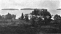
St. Joseph Island is in the northwestern part of Lake Huron. It is part of the Canadian province of Ontario. At 365 km2 (141 sq mi) in area, it is the sixth largest lake island in the world; the second largest island on Lake Huron, following Manitoulin Island; and the third largest of all the islands on the Great Lakes, trailing Manitoulin and Lake Superior's Isle Royale.

<span class="mw-page-title-main">Mackinaw cloth</span> Dense woolen cloth used to make jackets

Mackinaw cloth is a heavy and dense water-repellent woolen cloth, similar to Melton cloth but using a tartan pattern, often "buffalo plaid". It was used to make a short coat of the same name, sometimes with a doubled shoulder. These jackets have their origins on the Canadian frontier and were later made famous by Canadian and American loggers in the upper Midwest as workwear during the mid-19th century logging boom.

Major-General Robert McDouall, CB was a Scottish-born officer in the British Army, who saw much action during the Napoleonic Wars and the Anglo-American War of 1812. He is best known for serving as the commandant of Fort Mackinac from 1814 until the end of the War of 1812.

<span class="mw-page-title-main">Battle of Mackinac Island (1814)</span> Historic site in Mackinac Island, Michigan

The Battle of Mackinac Island was a British victory in the War of 1812. Before the war, Fort Mackinac had been an important American trading post in the straits between Lake Michigan and Lake Huron. It was important for its influence and control over the Native American tribes in the area, which was sometimes referred to in historical documents as "Michilimackinac".

The series of Engagements on Lake Huron left the British in control of the lake and their Native American allies in control of the Old Northwest for the latter stages of the War of 1812.

<span class="mw-page-title-main">War of 1812 campaigns</span>

The following is a synopsis of the land campaigns of the War of 1812.

<span class="mw-page-title-main">Siege of Fort Mackinac</span>

<span class="mw-page-title-main">Fort St. Joseph (Ontario)</span>

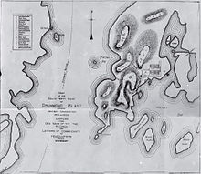
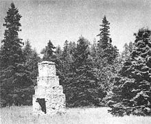
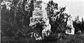
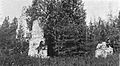
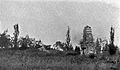
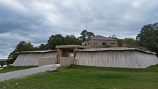
Fort St. Joseph is a former British outpost on the southernmost point of St. Joseph Island in Ontario, Canada, on Lake Huron. The fort consisted of a blockhouse, powder magazine, bakery building, Indian council house and storehouse surrounded by a palisade.

<span class="mw-page-title-main">Andrew Bulger</span>

Andrew H. Bulger (1789–1858) was a soldier and colonial administrator, born at St John's in the Crown Colony of Newfoundland.

<span class="mw-page-title-main">Battle of Fort Peter</span> Battle of the War of 1812

The Battle of Fort Point Peter was a successful attack in early 1815 by a British force on a smaller American force on the Georgia side of the St. Marys River near St. Marys, Georgia. The river was then part of the international border between the United States and British-allied Spanish Florida; it now forms part of the boundary between Georgia and Florida. Occupying coastal Camden County allowed the British to blockade American transportation on the Intracoastal Waterway. The attack on Forts St. Tammany and Peter occurred in January 1815, after the signing of the Treaty of Ghent, which would end the War of 1812, but before the treaty's ratification. The attack occurred at the same time as the siege of Fort St. Philip in Louisiana and was part of the British occupation of St. Marys and Cumberland Island.

Elizabeth Bertrand, known as Elizabeth Mitchell after her marriage to the British army surgeon David Mitchell, was a prominent Anishinaabe fur trader and political leader around the Straits of Mackinac in the early 19th century. In her native Ojibwe language she was known as Omagigiwikway.

References

  1. 1 2 "National Register Information System". National Register of Historic Places . National Park Service. July 9, 2010. Retrieved May 4, 2012.
  2. 1 2 3 4 5 6 7 8 9 Staff. "Fort Colyer". Historic Sites Online. Michigan State Housing Development Authority. Archived from the original on December 24, 2012. Retrieved May 2, 2012.
  3. Cook, p. 25.
  4. Cook, p. 32.
  5. Cook, p. 40.
  6. 1 2 Cook, pp. 42–3.
  7. Cook, pp. 47–8.
  8. 1 2 Cook, pp. 63–5.
  9. Cook, pp. 66–7.
  10. 1 2 Cook, pp. 79–81.
  11. Cook, pp. 83–5.
  12. 1 2 Cook, p. 12–3.
  13. Cook, p. 15.
  14. Cook, p. 8.
  15. Cook, p. 21.
  16. 1 2 Sandell, Dean. "Historical: Whitney Bay Area". Drummond Island Chamber of Commerce. Retrieved May 5, 2012.
  17. 1 2 Great Lakes Shoreline Recreation Area Survey (1959). Remaining Shoreline Opportunities in Minnesota, Wisconsin, Illinois, Indiana, Ohio, Michigan, Pennsylvania, New York (Report). National Park Service. Retrieved May 4, 2012.

Works cited