Sault Ste. Marie Historic Commercial District

Last updated
Sault Ste. Marie Historic Commercial District
Sault Sainte Marie Canal celebration c1905.jpg
Ashmun Street, 1905
USA Michigan location map.svg
Red pog.svg
Usa edcp location map.svg
Red pog.svg
LocationAshmun St. between Water and Easterday Sts., Portage Ave. between Brady and Ferris Sts., and Ashmun St. cross street blocks of Ridge, Maple, Arlington, Ann, and Spruce Sts., Sault Ste. Marie
Coordinates 46°30′1″N84°20′45″W / 46.50028°N 84.34583°W / 46.50028; -84.34583 Coordinates: 46°30′1″N84°20′45″W / 46.50028°N 84.34583°W / 46.50028; -84.34583
Architectural style Italianate, Late Victorian, Richardsonian Romanesque, and Commercial Brick, Neoclassical, Colonial Revival
NRHP reference No. 100005683 [1]
Added to NRHPOctober 19, 2020

The Sault Ste. Marie Historic Commercial District is a primarily commercial historic district located in Sault Ste. Marie, Michigan. It was listed on the National Register of Historic Places in 2020. [1] The district includes the Old Federal Building, Chippewa County Courthouse, Central Methodist Episcopal Church, the Adams Building, and the Gowan Block, all of which are listed separately on the National Register.

Contents

History

Sault Ste. Marie was first settled by European immigrants in 1668. It was controlled by Britain or France until after the War of 1812, when the border between Canada and the United States was fixed at the St. Marys River. As settlement of Michigan's Upper Peninsula increased, Sault Ste. Marie grew, due to its strategic location on the portage route around the rapids. This was accelerated by the 1840s copper boom, and more so by the construction of the first American lock in 1855. By this time, the early commercial center of the city along Water Street was expanded along nearby Ashmun Street. The twelve commercial enterprises in the city in 1856 grew to 70 by 1879. [2]

The city boomed in the 1880 and 1890s, with a number of buildings constructed. The move of the commercial center from Water Street to Ashmun was accelerated by two things: the 1892 relocation of Fort Brady, which opened up real estate, and two disastrous fires in 1886 and 1896, which destroyed many of the commercial buildings on Water Street. A hydroelectric power canal was constructed in the early 20th century, and the commercial district expanded even more rapidly in response. Construction slowed down in the 1910s and 20s, and even more in the 1930s due to the Great Depression. Construction picked up after World War II, but the downtown declined in the 1950s and 1960s as urban sprawl drew people away from the commercial core of the city. However, more recently, the Downtown Development Authority has reinvigorated the downtown area. [2]

Description

The Sault Ste. Marie Commercial Historic District includes the historic business district in the center of the city, and the nearby houses of early residents and business leaders. This district contains 146 buildings, of which 104 contribute to the historical character of the neighborhood. The buildings are mostly two stories in height, and were constructed between c.1820 and 1968, although most date from the late nineteenth century. Architectural styles include Italianate, Late Victorian, Richardsonian Romanesque, and Commercial Brick commercial buildings, Neoclassical public buildings, and vernacular and Colonial Revival houses. [2]

The commercial blocks of the district are located along the five blocks of Ashmun Street south to the Power Canal, and the adjacent blocks east and west along Portage Avenue. Although the district is predominantly commercial, it also includes with several government buildings and religious properties, as well as historic residences along Water and Bingham streets, most of which have been converted to commercial use. [2]

Related Research Articles

<span class="mw-page-title-main">Chippewa County, Michigan</span> County in Michigan, United States

Chippewa County is a county in the Upper Peninsula of the U.S. state of Michigan. As of the 2020 Census, the population was 36,785. The county seat is Sault Ste. Marie. The county is named for the Ojibwe (Chippewa) people, and was set off and organized in 1826.

<span class="mw-page-title-main">Sault Ste. Marie, Michigan</span> City in Michigan, United States

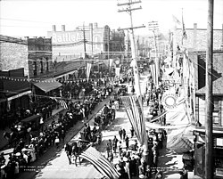
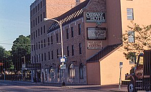
Sault Ste. Marie is the only city in, and county seat of, Chippewa County in the U.S. state of Michigan. With a population of 13,337 at the 2020 census, it is the second-most populated city in the Upper Peninsula after Marquette. It is the central city of the Sault Ste. Marie, MI Micropolitan Statistical Area, which encompasses all of Chippewa County and had a population of 38,520 at the 2010 census.

<span class="mw-page-title-main">St. Marys River (Michigan–Ontario)</span> River in Canada, United States

The St. Marys River, sometimes written St. Mary's River, drains Lake Superior, starting at the end of Whitefish Bay and flowing 74.5 miles (119.9 km) southeast into Lake Huron, with a fall of 23 feet (7.0 m). For its entire length it is an international border, separating Michigan in the United States from Ontario, Canada.

Gowan may refer to:

<span class="mw-page-title-main">Sault Tribe of Chippewa Indians</span> Reservation

The Sault Ste. Marie Tribe of Chippewa Indians, commonly shortened to Sault Tribe of Chippewa Indians or the more colloquial Soo Tribe, is a federally recognized Native American tribe in what is now known as Michigan's Upper Peninsula. The tribal headquarters is located within Sault Ste. Marie, the major city in the region, which is located on the St. Marys River.

<span class="mw-page-title-main">M-129 (Michigan highway)</span> State highway in Mackinac and Chippewa counties in Michigan, United States

M-129 is a state trunkline highway in the Upper Peninsula (UP) of the US state of Michigan. It runs from Cedarville to Sault Ste. Marie. South of Nine Mile Road in Chippewa County, M-129 overlays the Michigan Meridian. The section of M-129 that overlays the meridian is named Meridian Road. The highway between M-48 and the northern terminus is a part of the larger Lake Huron Circle Tour.

<span class="mw-page-title-main">Sault Ste. Marie Canal</span> Historic site in Sault Ste. Marie, Ontario

The Sault Ste. Marie Canal is a National Historic Site in Sault Ste. Marie, Ontario, and is part of the national park system, managed by Parks Canada. It includes a lock to bypass the rapids on the St. Marys River.

<span class="mw-page-title-main">West Canfield Historic District</span> Historic district in Michigan, United States

The West Canfield Historic District is a neighborhood historic district located primarily on Canfield Avenue between Second and Third Streets in Detroit, Michigan. A boundary increase enlarged the district to include buildings on Third Avenue between Canfield and Calumet. The district was designated a Michigan State Historic Site in 1970 and listed on the National Register of Historic Places in 1971; a boundary increase was added in 1997. The revitalized 1870s era neighborhood is one of the residential areas surrounding the city's Cultural Center Historic District in Midtown. Nearby, East Canfield Avenue leads to the Detroit Medical Center complex, the Romanesque Revival styled St. Josaphat's Catholic Church, and the Gothic revival styled Sweetest Heart of Mary Catholic Church.

Central Methodist Episcopal Church may refer to:

<span class="mw-page-title-main">Old Federal Building (Sault Ste. Marie)</span> United States historic place

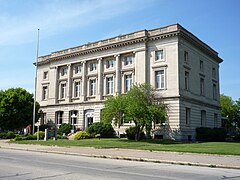
The United States Post Office at 209 East Portage Avenue in Sault Ste. Marie, Michigan, is an historic building which has served various purposes since its construction in the early 20th century. The building was listed on the National Register of Historic Places on September 9, 1977.

<span class="mw-page-title-main">Sault Ste. Marie, Ontario</span> City in Ontario, Canada

Sault Ste. Marie is a city in Ontario, Canada. It is at the St. Mary's River on the Canada–US border. It is the third largest city in Northern Ontario, after Sudbury and Thunder Bay.

<span class="mw-page-title-main">Central Methodist Episcopal Church (Sault Ste. Marie, Michigan)</span> Historic church in Michigan, United States

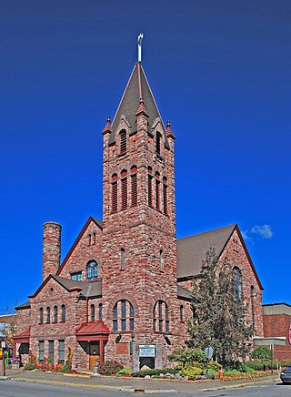
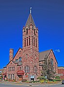
Central Methodist Episcopal Church is a United States historic church at 111 E. Spruce Street in Sault Ste. Marie, Michigan. It was listed on the National Register of Historic Places in 1984 and designated a Michigan State Historic Site in 1993.

<span class="mw-page-title-main">Saint James' Episcopal Church (Sault Ste. Marie, Michigan)</span> Historic church in Michigan, United States

Saint James' Episcopal Church is a historic church at 533 Bingham Avenue in Sault Ste. Marie, Michigan. It was added to the National Register of Historic Places in 1998.

<span class="mw-page-title-main">Adams Building (Sault Ste. Marie, Michigan)</span> United States historic place

The Adams Building, also known as the Central Savings Bank Building, was built as a commercial and office building located at 418 Ashmun Street in Sault Ste. Marie, Michigan. Along with the next-door Gowan Block, it is now part of the Park Place City Center, a mixed commercial and residential development. It was listed on the National Register of Historic Places in 2010.

<span class="mw-page-title-main">Gowan Block</span> Historic commercial building in Sault Ste. Marie, Michigan, USA

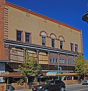
The Gowan Block, also known as the Masonic Block, was built as a commercial building and meeting hall located at 416 Ashmun Street in Sault Ste. Marie, Michigan. Along with the next-door Adams Building, it is now part of the Park Place City Center, a mixed commercial and residential development. It was listed on the National Register of Historic Places in 2010.

<span class="mw-page-title-main">Chippewa County Courthouse</span> United States historic place

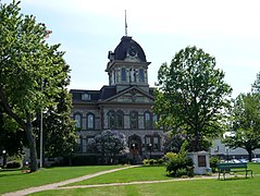
The Chippewa County Courthouse is a government building located on Court Street in Sault Ste. Marie, Michigan. It was listed on the National Register of Historic Places in 1984. It is one of the oldest courthouses still in use in Michigan.

<span class="mw-page-title-main">Elmwood (Sault Ste. Marie, Michigan)</span> Historic house in Michigan, United States

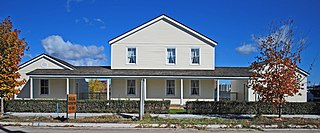
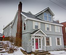
Elmwood, also known as the Henry Rowe Schoolcraft House, the Schoolcraft House or the Indian Agency, is a frame house located at 435 East Water Street in Sault Ste. Marie, Michigan. It was designated a Michigan State Historic Site in 1956 and listed on the National Register of Historic Places in 1974.

<span class="mw-page-title-main">Saint Marys Falls Hydropower Plant</span> Dam in Sault Ste. Marie, Michigan

The Saint Marys Falls Hydropower Plant is an 18-MW hydroelectric generating plant located in Sault Ste. Marie, Michigan. It extracts water from the St. Marys River under the supervision of the Army Corps of Engineers, and the power is taken up and distributed by the Cloverland Electric Cooperative, a rural utility that serves the Soo area.

<span class="mw-page-title-main">Kewadin Casinos</span>

The Kewadin Casinos are a set of casinos located in the US state of Michigan. The casinos are owned by the federally recognized Sault Tribe of Chippewa Indians. The primary property is located in Sault Ste. Marie, with additional locations on tribal lands in Christmas, Hessel, Manistique, and St. Ignace.

<span class="mw-page-title-main">Charlotte Central Historic District</span> United States historic place

The Charlotte Central Historic District is a mixed commercial, residential, and historic district located in the downtown section of Charlotte, Michigan. The district stretches along Cochran Avenue from West McClure Street to south of Henry Street, containing portions of the streets adjacent to Cochran. It was listed on the National Register of Historic Places in 2020.

References

  1. 1 2 "Weekly List of Actions Taken on Properties: 10/19/20 - 10/22/20". National Park Service. October 23, 2020. Retrieved October 23, 2020.
  2. 1 2 3 4 William Rutter (March 20, 2019), National Register of Historic Places Registration Form: Sault Ste. Marie Historic Commercial District (PDF), Michigan State Historic Preservation Office