Soo Locks

Last updated

St. Marys Falls Canal
Soo Locks-Sault-Ste Marie.png
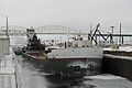
Aerial view of the Soo Locks. View is looking east, with Canada on the left and the United States on the right
USA Michigan location map.svg
Red pog.svg
Usa edcp location map.svg
Red pog.svg
Location Sault Ste. Marie, Michigan
Coordinates 46°30′12″N84°21′00″W / 46.50333°N 84.35000°W / 46.50333; -84.35000
Built1855;168 years ago (1855)
ArchitectCorps of Engineers
NRHP reference No. 66000394 [1]
Significant dates
Added to NRHPNovember 13, 1966
Designated NHLNovember 13, 1966 [2]
Designated MSHSFebruary 12, 1959 [3]

The Soo Locks (sometimes spelled Sault Locks but pronounced "soo") are a set of parallel locks, operated and maintained by the United States Army Corps of Engineers, Detroit District, that enable ships to travel between Lake Superior and the lower Great Lakes. They are located on the St. Marys River between Lake Superior and Lake Huron, between the Upper Peninsula of the U.S. state of Michigan and the Canadian province of Ontario. They bypass the rapids of the river, where the water falls 21 ft (6.4 m). The locks pass an average of 10,000 ships per year, [4] despite being closed during the winter from January through March, when ice shuts down shipping on the Great Lakes. The winter closure period is used to inspect and maintain the locks.

Contents

The locks share a name (usually shortened and anglicized as Soo) with the two cities named Sault Ste. Marie, in Ontario and in Michigan, located on either side of the St. Marys River. The Sault Ste. Marie International Bridge between the United States and Canada permits vehicular traffic to pass over the locks. A railroad bridge crosses the St. Marys River just upstream of the highway bridge.

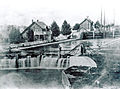
The first locks were opened in 1855. Along with the Erie Canal, constructed in 1824 in central New York State, they were among the great infrastructure engineering projects of the antebellum United States. The Soo Locks were designated a National Historic Landmark in 1966. [5]

During World War II, the Soo Locks and the St. Marys River waterway were intensely guarded by U.S. and Canadian forces coordinated by the U.S. Army's Central Defense Command, as they were considered integral to continued shipping traffic on the Lakes. A one-way German air attack on the locks by forces based in Norway was thought to be possible. [6]

United States locks

The U.S. locks form part of a 1.6 mi (2.6 km) canal formally named the St. Marys Falls Canal. The entire canal, including the locks, is owned and maintained by the [[United States Army Corps of Engineers], which provides free passage. The first iteration of the U.S. Soo Locks was completed in May 1855; it was operated by the state of Michigan until transferred to the U.S. Army in 1881.

The first federal lock, the Weitzel Lock, was built in 1881 and was replaced by the MacArthur Lock in 1943. [7] [8] The configuration consists of two parallel lock chambers, each running east to west. Starting at the Michigan shoreline and moving north toward Ontario, these are:

A new lock is under construction and is slated to be completed by 2030. [12] Groundbreaking for the new lock project was held on June 30, 2009. [13] The lock will be equal in size to the Poe Lock and will provide much needed additional capacity for the large lake freighters. [14] The new lock replaces two locks (Davis Lock and Sabin Lock), which were obsolete and used infrequently. In May 2020, construction on Phase One of the replacement of the Sabin Lock was started.

North of the new lock is an additional channel with a small hydroelectric plant, which provides electricity for the lock complex.

McArthur Lock Panorama.jpg
MacArthur Lock, facing north

Engineers Day

The U.S. Army Corps of Engineers, Detroit District, operates the Soo Locks Visitors Center and viewing deck for the public. [15] On the last Friday of every June, the public is allowed to go behind the security fence and cross the lock gates of the U.S. Soo Locks for the annual Engineers Day Open House. [16] [17] During this event, visitors are able to get close enough to touch ships passing through the two regularly operating locks. Other than on that day, because the locks are United States Federal property under command of the U.S. Army Corps of Engineers, unauthorized personnel and civilians are restricted from the locks under threat of fines or imprisonment for trespassing.

Canadian lock

A single small lock is operated on the Canadian side of the Soo. Opened in 1895, it was rebuilt in 1987, and is 77 m (253 ft) long, 15.4 m (51 ft) wide and 13.5 m (44 ft) deep. [18] The Canadian lock is used for recreational and tour boats; major shipping traffic uses the U.S. locks.

Related Research Articles

<span class="mw-page-title-main">Lake Superior</span> Largest of the Great Lakes of North America

Lake Superior is the largest freshwater lake in the world by surface area and the third-largest by volume, holding 10% of the world's surface fresh water. Located in central North America, it is the northernmost and westernmost of the Great Lakes of North America, straddling the Canada–United States border with the Canadian province of Ontario to the north and east and the U.S. states of Minnesota to the west and Wisconsin and Michigan to the south. It drains into Lake Huron via St. Marys River, then through the lower Great Lakes to the St. Lawrence River and ultimately the Atlantic Ocean.

<span class="mw-page-title-main">St. Lawrence Seaway</span> Locks and canals in the US and Canada

The St. Lawrence Seaway is a system of locks, canals, and channels in Canada and the United States that permits oceangoing vessels to travel from the Atlantic Ocean to the Great Lakes of North America, as far inland as Duluth, Minnesota, at the western end of Lake Superior. The seaway is named for the St. Lawrence River, which flows from Lake Ontario to the Atlantic Ocean. Legally, the seaway extends from Montreal, Quebec, to Lake Erie, and includes the Welland Canal. Ships from the Atlantic Ocean are able to reach ports in all five of the Great Lakes, via the Great Lakes Waterway.

<span class="mw-page-title-main">Sault Ste. Marie, Michigan</span> City in Michigan, United States

Sault Ste. Marie is a city in the Upper Peninsula of the U.S. state of Michigan. It is the county seat of Chippewa County and is the only city within the county. With a population of 13,337 at the 2020 census, it is the second-most populated city in the Upper Peninsula, behind Marquette. It is the primary city of the Sault Ste. Marie, MI Micropolitan Statistical Area, which encompasses all of Chippewa County and had a population of 36,785 at the 2020 census. Sault Ste. Marie was settled by mostly French colonists in 1668, making it the oldest city in Michigan.

<span class="mw-page-title-main">St. Marys River (Michigan–Ontario)</span> River in Canada, United States

The St. Marys River, sometimes written St. Mary's River, drains Lake Superior, starting at the end of Whitefish Bay and flowing 74.5 miles (119.9 km) southeast into Lake Huron, with a fall of 23 feet (7.0 m). For its entire length it is an international border, separating Michigan in the United States from Ontario, Canada.

<span class="mw-page-title-main">Sault Ste. Marie International Bridge</span> Bridge connecting Canada and the United States

The Sault Ste. Marie International Bridge spans the St. Marys River between the United States and Canada connecting the twin cities of Sault Ste. Marie, Michigan and Sault Ste. Marie, Ontario. The bridge is operated by the International Bridge Administration under the direction of the Sault Ste. Marie Bridge Authority, a bi-national governing body consisting of four directors appointed by the Governor of Michigan and four appointed by the Canadian government-owned Federal Bridge Corporation.

<span class="mw-page-title-main">Lake freighter</span> Ship type

Lake freighters, or lakers, are bulk carrier vessels that operate on the Great Lakes of North America. These vessels are traditionally called boats, although classified as ships.

<span class="mw-page-title-main">Sault Tribe of Chippewa Indians</span> Reservation

The Sault Ste. Marie Tribe of Chippewa Indians, commonly shortened to Sault Tribe of Chippewa Indians or the more colloquial Soo Tribe, is a federally recognized Native American tribe in what is now known as Michigan's Upper Peninsula. The tribal headquarters is located within Sault Ste. Marie, the major city in the region, which is located on the St. Marys River.

<span class="mw-page-title-main">Illinois Waterway</span> Canal system in Illinois

The Illinois Waterway system consists of 336 miles (541 km) of navigable water from the mouth of the Calumet River at Chicago to the mouth of the Illinois River at Grafton, Illinois. Based primarily on the Illinois River, it is a system of rivers, lakes, and canals that provide a shipping connection from the Great Lakes to the Gulf of Mexico via the Illinois and Mississippi rivers.

<span class="mw-page-title-main">Sault Ste. Marie Canal</span> Historic site in Sault Ste. Marie, Ontario

The Sault Ste. Marie Canal is a National Historic Site in Sault Ste. Marie, Ontario, and is part of the national park system, managed by Parks Canada. It includes a lock to bypass the rapids on the St. Marys River.

<span class="mw-page-title-main">Orlando Metcalfe Poe</span> American general and civil engineer

Orlando Metcalfe Poe was a United States Army officer and engineer in the American Civil War. After helping General William Tecumseh Sherman's March to the Sea, he was responsible for much of the early lighthouse construction on the Great Lakes and design of the Poe Lock at Soo Locks between lakes Superior and Huron.

Sault may refer to:

SS <i>Kamloops</i> Lake freighter of Canada Steamship Lines

SS Kamloops was a Canadian lake freighter that was part of the fleet of Canada Steamship Lines from its launching in 1924 until it sank with all hands in Lake Superior off Isle Royale, Michigan, United States, on or about 7 December 1927.

<span class="mw-page-title-main">U.S. Army Corps of Engineers Duluth Vessel Yard</span> United States historic place

The U.S. Army Corps of Engineers Duluth Vessel Yard is a federal port facility in Duluth, Minnesota, United States. It houses the United States Army Corps of Engineers (USACE) resources used to maintain the harbors of the Twin Ports of Duluth and Superior, Wisconsin. It was established on Minnesota Point in 1903, though most of its present configuration dates to a flurry of construction in 1941.

<span class="mw-page-title-main">Edison Sault Power Canal</span> Canal in Michigan, United States of America

The Edison Sault Power Canal supplies the Saint Marys Falls Hydropower Plant, a Cloverland Electric Cooperative hydroelectric plant, in Sault Ste. Marie, Michigan. Excavation of the power canal began in September 1898 and was completed in June 1902. The canal and hydroelectric complex were named a Historic Civil Engineering Landmark in 1983.

<span class="mw-page-title-main">Sault Ste. Marie Bridge Company</span> Bridge

Sault Ste. Marie Bridge Company is a subsidiary of the Wisconsin Central Ltd. It operates a railroad bridge over the St. Marys River between Sault Ste. Marie, Michigan and Sault Ste. Marie, Ontario.

<span class="mw-page-title-main">Sault Ste. Marie International Railroad Bridge</span> Bridge connecting Canada and the United States

The Sault Ste. Marie Railroad Bridge was originally built in 1887 to facilitate rail traffic crossing St. Marys River and the international border between Sault Ste. Marie, Michigan and Sault Ste. Marie, Ontario. It runs parallel to the Sault Ste. Marie International Bridge. It has nine Camelback spans and carries a single line of track.

<span class="mw-page-title-main">Sault Ste. Marie, Ontario</span> City in Ontario, Canada

Sault Ste. Marie is a city in Ontario, Canada. The third-largest city in Northern Ontario after Sudbury and Thunder Bay, it is located on the St. Mary's River on the Canada–US border. To the southwest, across the river, is the United States and the Michigan city of the same name. The two cities are joined by the Sault Ste. Marie International Bridge, which connects Interstate 75 on the Michigan side and Huron Street on the Ontario side. Shipping traffic in the Great Lakes system bypasses the Saint Mary's Rapids via the American Soo Locks, the world's busiest canal in terms of tonnage that passes through it, while smaller recreational and tour boats use the Canadian Sault Ste. Marie Canal.

<span class="mw-page-title-main">Saint Marys Falls Hydropower Plant</span> Dam in Sault Ste. Marie, Michigan

The Saint Marys Falls Hydropower Plant is an 18-MW hydroelectric generating plant located in Sault Ste. Marie, Michigan. It extracts water from the St. Marys River under the supervision of the Army Corps of Engineers, and the power is taken up and distributed by the Cloverland Electric Cooperative, a rural utility that serves the Soo area.

The Bertrand H. Snell Lock is situated on the St Lawrence River leg of the St Lawrence Seaway and is one of the seven canal locks found along the length of the seaway. The lock has a 45 ft (14 m) lift for ships traveling upstream. It is situated near Massena, New York along with one of the other locks.

References

  1. "National Register Information System". National Register of Historic Places . National Park Service. January 23, 2007.
  2. "St. Marys Falls Canal". National Historic Landmark summary listing. National Park Service. Archived from the original on October 6, 2012. Retrieved June 27, 2008.
  3. State Historic Preservation Office (2009). "Saint Mary's Falls Canal". Historic Sites Online. Michigan State Housing Development Authority. Archived from the original on May 11, 2012. Retrieved June 26, 2010.
  4. Detroit District. "Facts". United States Army Corps of Engineers. Archived from the original on January 10, 2011. Retrieved October 22, 2008.
  5. "NHL nomination for St. Marys Falls Canal". National Park Service. Archived from the original on August 28, 2022. Retrieved April 3, 2017.
  6. Conn, Stetson; Engelman, Rose C.; Fairchild, Byron (2000) [1964]. Guarding the United States and its Outposts. United States Army in World War II. Washington, D.C.: Center of Military History, United States Army. pp. 102–105. Archived from the original on December 25, 2007. Retrieved June 14, 2018.
  7. Saint Marys Falls Ship Canal (Soo Locks Historic District, Soo Canals), Michigan Department of Labor and Economic Opportunity, 2020.
  8. Lange, Alex, "The Mighty Soo: Construction of the Locks at Sault Ste. Marie, Michigan" Archived January 28, 2020, at the Wayback Machine , The Unwritten Record. National Archives, January 5, 2017.
  9. 1 2 David Helwig (March 30, 2002). "$227 million lock replacement could start this year". SooToday.com. Archived from the original on September 20, 2002. Retrieved July 12, 2012.
  10. Arbic, Bernard; Steinhaus, Nancy (2005). Upbound Downbound: The Story of the Soo Locks. Allegan Forest, MI: Priscilla Press. pp. 35–37.
  11. 1 2 "Seeing The Light: Orlando Metcalfe Poe". Terrypepper.com. May 30, 2000. Archived from the original on October 14, 2009. Retrieved April 10, 2012.
  12. "New Lock Info Sheet" (PDF). May 2020. Archived (PDF) from the original on May 15, 2021. Retrieved February 9, 2021.
  13. "Construction beginning on new Soo shipping lock". Detroit Free Press . June 30, 2009. Archived from the original on July 7, 2009. Retrieved July 13, 2009.
  14. David Helwig (March 30, 2002). "$227 million lock replacement could start this year". SooToday.com. Archived from the original on September 20, 2002. Retrieved July 12, 2012.
  15. "Chapter 4: The Watery Boundary". United Divide: A Linear Portrait of the USA/Canada Border. The Center for Land Use Interpretation. Winter 2015. Archived from the original on June 20, 2018. Retrieved November 14, 2017.
  16. Detroit District. "Soo Locks: Sault Ste- Marie". United States Army Corps of Engineers. Archived from the original on January 31, 2011. Retrieved March 5, 2011.
  17. "Soo Locks Engineer's Day". June 24, 2010. Archived from the original on January 6, 2011. Retrieved March 5, 2011.
  18. Parks Canada. "Sault Ste. Marie Canal National Historic Site of Canada, Natural Wonders & Cultural Treasures". Parks Canada. Archived from the original on July 18, 2006.

Further reading