Buckhorn Island State Park is an 895-acre (3.62 km2) state park located in Erie County, New York in the Town of Grand Island. The park is on the northern end of the island of Grand Island.
Joseph Davis State Park is a 388-acre (1.57 km2) state park located along the banks of the lower Niagara River in the Town of Lewiston in Niagara County, New York.
Selkirk Shores State Park is a 980-acre (4.0 km2) state park located in the Town of Richland in Oswego County, New York. The park is located on the eastern shore of Lake Ontario.
Long Point State Park – Thousand Islands is a 23-acre (0.093 km2) state park located at the northeast tip of Point Peninsula on Lake Ontario's Chaumont Bay. The park is located in the Town of Lyme in Jefferson County, New York.
Heckscher State Park is a 1,657-acre (6.71 km2) state park on the shore of the Great South Bay at East Islip in Suffolk County, New York, USA.

Orient Beach State Park is a 363-acre (1.47 km2) state park located in Southold, New York. The park is situated at the tip of the North Fork of Long Island.

Bayswater Point State Park is a 17-acre (0.069 km2) state park located on Jamaica Bay in Queens, New York. The park is located at the western end of Mott Avenue in Bayswater near Far Rockaway and is built on land that once housed the mansion and estate of banker Louis A. Heinsheimer.
Bowman Lake State Park is a 653-acre (2.64 km2) state park located in Chenango County, New York. The park is located in the Town of McDonough, north of the community of East McDonough.

Nissequogue River State Park is a 521-acre (2.11 km2) state park located on the banks and bluffs of the Nissequogue River in Kings Park, New York. The park was opened in 2000, and established on the waterfront portion of the former Kings Park Psychiatric Center.

The New York State Department of Environmental Conservation is a department of New York state government. The department guides and regulates the conservation, improvement, and protection of New York's natural resources; manages Forest Preserve lands in the Adirondack and Catskill parks, state forest lands, and wildlife management areas; regulates sport fishing, hunting and trapping; and enforces the state's environmental laws and regulations. Its regulations are compiled in Title 6 of the New York Codes, Rules and Regulations. It was founded in 1970, replacing the Conservation Department, and is headed by Basil Seggos.

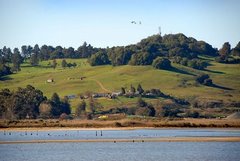
The Swan Bay is a shallow, 30-square-kilometre (12 sq mi) marine embayment at the eastern end of the Bellarine Peninsula in Port Phillip, Victoria, Australia. The township of Queenscliff lies at its southern end, and St Leonards at its northern. It is partly separated from Port Phillip by Swan Island, Duck Island and Edwards Point. Most of the area is included in the Port Phillip Heads Marine National Park as well as being listed as a wetland of international importance under the Ramsar Convention as part of the Port Phillip Bay and Bellarine Peninsula Ramsar Site. The bay is part of the Swan Bay and Port Phillip Bay Islands Important Bird Area, identified as such by BirdLife International because of its importance for orange-bellied parrots, waders and seabirds.

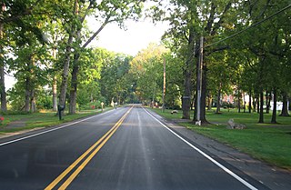
Caumsett State Historic Park Preserve is a state park on Lloyd Neck, a peninsula extending into the Long Island Sound, in the Village of Lloyd Harbor, New York. It is operated by the New York State Office of Parks, Recreation and Historic Preservation.
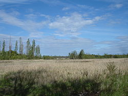
Great Baehre Swamp is a New York state wetland located inside the Town of Amherst in Erie County, New York, United States. The area is characterized as a silver maple-ash swamp of 270 acres (1.1 km2), much of which is protected by conservation areas owned by the town and New York State.

New York State Wildlife Management Areas (WMAs) are conservation areas managed by the New York State Department of Environmental Conservation (NYSDEC) primarily for the benefit of wildlife, and used extensively by the public for hunting, fishing, and trapping. As of 2016, the NYSDEC owns and maintains 113 WMAs, with a total area of approximately 197,000 acres. The Wildlife Management Areas program is administered by the Division of Fish, Wildlife and Marine Resources of the NYSDEC.

New York State Forests are public lands administered by the Division of Lands and Forests of the New York State Department of Environmental Conservation (NYSDEC). New York State Forests are designated as reforestation, multiple use, and unique areas; and state nature and historic preserves, with approximately 600,000 acres (2,400 km2) classified as reforestation areas and approximately 9,000 acres (36 km2) classified as multiple use lands. Land within the Adirondack Park or the Catskill Park is not included as part of the State Forest system.
Shollenberger Park is a 165-acre (0.67 km2) wetland park located in Petaluma, California. Together with the 80-acre (320,000 m2) Alman Marsh, and 260-acre (1.1 km2) Ellis Creek which opened to the public in July 2009, a total of 505 acres (2.04 km2) are accessible to the public. The entirety is referred to as the "Petaluma Wetlands".

Freshkills Park is a public park being built atop a former landfill on Staten Island. At about 2,200 acres (8.9 km2), it will be the largest park developed in New York City since the 19th century. Its construction began in October 2008 and is slated to continue in phases for approximately 30 years. When fully developed by 2035–2037, Freshkills Park will be the second-largest park in New York City, after Pelham Bay Park in the Bronx, and almost three times the size of Central Park in Manhattan. The park is envisioned as a regional destination that integrates open grasslands, waterways and engineered structures into a cohesive and dynamic unit for social, cultural and physical activity, learning and play. Sections of the park will be connected by a circulation system for vehicles and a network of paths for bicyclists and pedestrians. The New York City Department of Parks and Recreation is managing the project with the New York City Department of Sanitation.

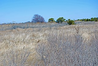
Abbotts Lagoon is a lagoon on the northwestern coast of the Point Reyes National Seashore, southwest of Tomales Point, in California, United States. The inland portion of the lagoon receives freshwater runoff, but the lagoon may be brackish from occasional winter tidal exchange along its western edge. The eastern shore of the lagoon is covered with old growth northern coastal scrub including coyote bush, yellow bush lupine, sword fern and California blackberry.
Galop Island is an uninhabited island in the Saint Lawrence River located in St. Lawrence County, northeast of Ogdensburg, New York. The 675-acre (2.73 km2) island is owned by the New York Power Authority and managed by the New York State Office of Parks, Recreation and Historic Preservation as the undeveloped Galop Island State Park.