The Santa Monica Mountains is a coastal mountain range in Southern California, next to the Pacific Ocean. It is part of the Transverse Ranges. The Santa Monica Mountains National Recreation Area encompasses this mountain range. Because of its proximity to densely populated regions, it is one of the most visited natural areas in California.
Bear Mountain State Park is a 5,205-acre (21.06 km2) state park located on the west bank of the Hudson River in Rockland and Orange counties, New York. The park offers biking, hiking, boating, picnicking, swimming, cross-country skiing, cross-country running, sledding and ice skating. It also includes several facilities such as the Perkins Memorial Tower, the Trailside Museum and Zoo, the Bear Mountain Inn, a merry-go-round, pool, and a skating rink. It also hosts the Bear Mountain Circle, where the historic Palisades Interstate Parkway and Bear Mountain Bridge meet. It is managed by the Palisades Interstate Park Commission, which is overseen by the State of New York.

Peebles Island State Park is a 190-acre (0.77 km2) state park located at the confluence of the Mohawk and Hudson rivers in New York. A majority of the park is located in Saratoga County, with a smaller portion located in Albany County.
Bristol Beach State Park is a 242-acre (0.98 km2) undeveloped state park located on the Hudson River in the town of Saugerties in Ulster County, New York. The park was initially formed in 1967, and is managed by the Palisades Interstate Park Commission.
Grass Point State Park is a 114-acre (0.46 km2) state park located in the Town of Orleans in Jefferson County, New York. The park is located along the St. Lawrence River by NY 12 and NY 180, between Clayton and Alexandria Bay.

Orient Beach State Park is a 363-acre (1.47 km2) state park located in Southold, New York. The park is situated at the tip of the North Fork of Long Island.

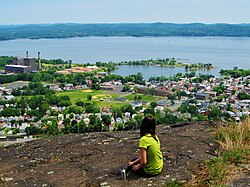
Rockland Lake State Park is a 1,133-acre (4.59 km2) state park located in the hamlets of Congers and Valley Cottage in the eastern part of the Town of Clarkstown in Rockland County, New York, United States. The park is located on a ridge of Hook Mountain above the west bank of the Hudson River. Included within the park is the 256-acre (1.04 km2) Rockland Lake.

Tallman Mountain State Park is a 687-acre (2.78 km2) state park in Rockland County, New York, located adjacent to the Hudson River in the Town of Orangetown just south of Piermont. It is part of the Palisades Interstate Park System.

Taughannock Falls State Park is a 750-acre (3.0 km2) state park located in the town of Ulysses in Tompkins County, New York in the United States. The park is northwest of Ithaca near Trumansburg.

Goosepond Mountain State Park, also known as Goose Pond Mountain State Park, is a 1,706-acre (6.90 km2) undeveloped state park located in Orange County, New York. The park is located within the Town of Chester and is administered by the Palisades Interstate Park Commission.
Higley Flow State Park is a 1,115-acre (4.51 km2) state park located in the town of Colton in St. Lawrence County, New York, United States. The park is located on Higley Flow and Warm Creek Flow, both of which were formed by the impoundment of the Raquette River.
Westcott Beach State Park is a 318-acre (1.29 km2) state park in Jefferson County, New York. The park is located at the eastern end of Lake Ontario in the Town of Henderson.

Nyack Beach State Park is a 61-acre (0.25 km2) state park in Upper Nyack, Rockland County, New York. It consists of a small parking lot and a riverfront pathway, the southernmost section of the Hudson River Valley Greenway. It is known for its physical proximity to the Hudson River on one side of the pathway and the looming cliffs of the Palisades rising 700 feet (210 m) above on the other side.
Chenango Valley State Park is a 1,137-acre (4.60 km2) state park located in Broome County, New York in the United States. The park is located adjacent to the Chenango River in western part of the Town of Fenton.
Highland Lakes State Park is a 3,115-acre (12.61 km2) undeveloped state park in the towns of Wallkill and Crawford in Orange County, New York, United States. The park is located northeast of the city of Middletown, west of Route 211. It is the largest undeveloped park managed by the Palisades Interstate Park Commission.

Eighteen Mile Creek is a tributary of Lake Erie located in southern Erie County, New York, United States. The creek is the second largest tributary of Lake Erie in New York State.

Franny Reese State Park is a 251-acre (1.02 km2) state park located in the Town of Lloyd in Ulster County, New York. The park is managed by Scenic Hudson and is part of the Palisades Interstate Park system.

Hook Mountain State Park is a 676-acre (2.74 km2) undeveloped state park located in Rockland County, New York. The park includes a portion of the Hudson River Palisades on the western shore of the Hudson River, and is part of the Palisades Interstate Park system. Hook Mountain State Park is functionally part of a continuous complex of parks that also includes Rockland Lake State Park, Nyack Beach State Park, and Haverstraw Beach State Park.
Haverstraw Beach State Park is a 73-acre (0.30 km2) state park located in the Haverstraw, New York. The park is included within the Palisades Interstate Park system and is functionally part of a continuous complex of parks that also includes Rockland Lake State Park, Hook Mountain State Park, and Nyack Beach State Park.