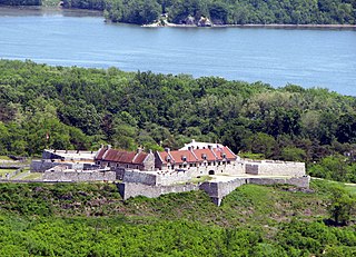
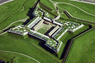
Fort Ticonderoga, formerly Fort Carillon, is a large 18th-century star fort built by the French at a narrows near the south end of Lake Champlain, in northern New York, in the United States. It was constructed by Canadian-born French military engineer Michel Chartier de Lotbinière, Marquis de Lotbinière between October 1755 and 1757, during the action in the "North American theater" of the Seven Years' War, often referred to in the US as the French and Indian War. The fort was of strategic importance during the 18th-century colonial conflicts between Great Britain and France, and again played an important role during the Revolutionary War.
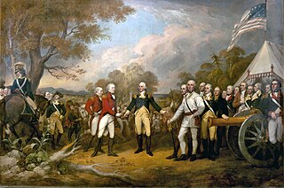
The Battles of Saratoga marked the climax of the Saratoga campaign, giving a decisive victory to the Americans over the British in the American Revolutionary War. British General John Burgoyne led an invasion army of 7,200–8,000 men southward from Canada in the Champlain Valley, hoping to meet a similar British force marching northward from New York City and another British force marching eastward from Lake Ontario; the goal was to take Albany, New York. The southern and western forces never arrived, and Burgoyne was surrounded by American forces in upstate New York 15 miles (24 km) short of his goal. He fought two battles which took place 18 days apart on the same ground 9 miles (14 km) south of Saratoga, New York. He gained a victory in the first battle despite being outnumbered, but lost the second battle after the Americans returned with an even larger force.
West Point is the oldest continuously occupied military post in the United States. Located on the Hudson River in New York, General George Washington stationed his headquarters there in the summer and fall of 1779, and later identified it as the most important strategic position in America during the American Revolution, calling it "the most important Post in America" in 1781. It was the site of General Benedict Arnold's infamous treason. West Point was first occupied by the military on January 27, 1778, when Brigadier General Samuel Holden Parsons and his brigade crossed the ice on the Hudson River and climbed to the plain on West Point. From then to the present, West Point has been occupied by the United States Army. It comprises approximately 16,000 acres (6,500 ha) including the campus of the United States Military Academy, which is commonly called "West Point" as well.
The Saratoga campaign in 1777 was an attempt by the British high command for North America to gain military control of the strategically important Hudson River valley during the American Revolutionary War. It ended in the surrender of the British army, which historian Edmund Morgan argues, "was a great turning point of the war, because it won for Americans the foreign assistance which was the last element needed for victory."
Fort Stanwix was a colonial fort whose construction commenced on August 26, 1758, under the direction of British General John Stanwix, at the location of present-day Rome, New York, but was not completed until about 1762. The bastion fort was built to guard a portage known as the Oneida Carry during the French and Indian War. Fort Stanwix National Monument, a reconstructed structure built by the National Park Service, now occupies the site.

Fort McClary is a former defensive fortification of the United States military located along the southern coast at Kittery Point, Maine at the mouth of the Piscataqua River. It was used throughout the 19th century to protect approaches to the harbor of Portsmouth, New Hampshire and the Portsmouth Naval Shipyard in Kittery. The property and its surviving structures are now owned and operated by the State of Maine as Fort McClary State Historic Site, including a blockhouse dating from 1844.
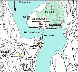
The Hudson River Chains were a series of chain booms constructed across the Hudson River at West Point by Continental Army forces from 1776 to 1778 during the American Revolutionary War. These served as defenses preventing British naval vessels from sailing upriver and were overseen by the Highlands Department of the Continental Army.

Fort Clinton was an American Revolutionary War fort erected by the Continental Army on the west bank of the Hudson River in 1776.

Fort Wadsworth is a former United States military installation on Staten Island in New York City, situated on The Narrows which divide New York Bay into Upper and Lower halves, a natural point for defense of the Upper Bay and Manhattan beyond. Prior to closing in 1994 it claimed to be the longest continually garrisoned military installation in the United States. It comprises several fortifications, including Fort Tompkins and Battery Weed and was given its present name in 1865 to honor Brigadier General James Wadsworth, who had been killed in the Battle of the Wilderness during the Civil War. Fort Wadsworth is now part of the Staten Island Unit of Gateway National Recreation Area, maintained by the National Park Service.

The Hudson Highlands are mountains on both sides of the Hudson River in New York state lying primarily in Putnam County on its east bank and Orange County on its west. They continue somewhat to the south in Westchester County and Rockland County, respectively.

Crown Point State Historic Site is the site of a former military stronghold at the south end of the wider part of Lake Champlain. The location is in Essex County, New York, United States. The site is on a peninsula in the town of Crown Point, New York.
Popolopen is the name of several related landmarks mainly within the Hudson Highlands of Orange County, New York. These include a mountain, Popolopen Torne—or simply "The Torne", and a short and steep-sided nearby valley officially called Hell Hole, but often Popolopen Gorge. Popolopen Creek runs through this valley. The Popolopen Bridge spans its mouth at the Hudson River and is crossed by Route 9W. Popolopen Lake feeds the headwaters of its namesake creek. Despite local usage, the United States Board on Geographical Names recognizes only the lake, creek and bridge as bearing the name "Popolopen."
Snyder's Regiment of Militia was known officially as The First Regiment of Ulster County Militia. It was the first regiment of four created in Ulster County, New York as ordered by the Provincial Congress of New York. It was also referred to as the Northern Regiment since its members were from the Northern section of Ulster County towns including Kingston, New York and Saugerties, New York

Mount Independence on Lake Champlain in Orwell, Vermont, was the site of extensive fortifications built during the American Revolutionary War by the American army to stop a British invasion. Construction began in July 1776, following the American defeat in Canada, and continued through the winter and spring of 1777. After the American retreat on July 5 and 6, 1777, British and Hessian troops occupied Mount Independence until November 1777.
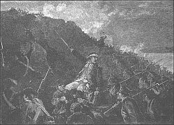
The Battle of Forts Clinton and Montgomery was an American Revolutionary War battle fought in the Hudson Highlands of the Hudson River valley, not far from West Point, on October 6, 1777. British forces under the command of General Sir Henry Clinton captured Fort Clinton and Fort Montgomery and then dismantled the first iteration of the Hudson River Chains. The purpose of the attack was to create a diversion to draw American troops from the army of General Horatio Gates, whose army was opposing British General John Burgoyne's attempt to gain control of the Hudson.

Fort Tompkins is a fort on Staten Island in New York City, within what is now Fort Wadsworth at the Narrows. Fort Tompkins guarded the landward approaches to other forts in the area from 1808 through circa 1898. The current fort was built 1847–1861, and was operational as a fort until superseded by new defenses circa 1898. It is now part of the Gateway National Recreation Area. It is the last remaining of four forts in New York State named Fort Tompkins.

Constitution Island is in the northeastern United States, located in New York on the east side of the Hudson River, north of New York City. It is directly opposite the U.S. Military Academy Reservation at West Point and is connected to the east shore by Constitution Marsh.
Major Christopher Tappen was an American politician from New York State. During the American Revolution, Tappen served as a member of the New York Provincial Congress, New York's Secret and Safety Committees, New York's Council of Safety and later in both the New York State Assembly and the New York State Senate. He also safely relocated and preserved the state's records and documents from destruction before the burning of Kingston by the British on October 16, 1777.