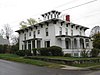
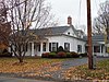
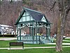
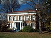
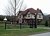
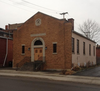
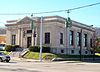
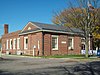
[3] Name on the Register Image Date listed [4] Location City or town Description 1 Addison Village Hall Addison Village Hall April 23, 1980 (# 80002771 Tuscarora and South Sts. 42°06′17″N 77°14′06″W / 42.104722°N 77.235°W / 42.104722; -77.235 (Addison Village Hall ) Addison It was demolished in 1994 and the site is now occupied by the Old Village Hall Memorial Park. 2 Adsit House Upload image February 20, 2003 (# 03000047 34 Main St. 42°19′42″N 77°39′49″W / 42.328333°N 77.663611°W / 42.328333; -77.663611 (Adsit House ) Hornell The house was demolished on June 15, 2010. [5] 3 James H. Bolton House James H. Bolton House February 23, 2015 (# 15000034 117 W. Washington St., 42°20′13″N 77°19′34″W / 42.336893°N 77.3260887°W / 42.336893; -77.3260887 (James H. Bolton House ) Bath Well-preserved 1909 Queen Anne Style house has many of its original interior finishings. 4 Campbell-Rumsey House Campbell-Rumsey House September 30, 1983 (# 83001795 225 E. Steuben St. 42°19′58″N 77°18′27″W / 42.332778°N 77.3075°W / 42.332778; -77.3075 (Campbell-Rumsey House ) Bath 5 Canisteo Living Sign Canisteo Living Sign July 16, 2004 (# 04000707 Southeast side of hill, north of Cemetery Rd. off Greenwood St. 42°15′59″N 77°36′53″W / 42.266389°N 77.614722°W / 42.266389; -77.614722 (Canisteo Living Sign ) Canisteo 6 Church of the Redeemer Church of the Redeemer November 12, 1992 (# 92001577 Junction of Park and Wall Sts. 42°06′30″N 77°13′58″W / 42.108333°N 77.232778°W / 42.108333; -77.232778 (Church of the Redeemer ) Addison 7 Cobblestone House Cobblestone House September 30, 1983 (# 83001796 120 W. Washington St. 42°20′15″N 77°19′28″W / 42.3375°N 77.324444°W / 42.3375; -77.324444 (Cobblestone House ) Bath 8 Corning Armory Corning Armory May 18, 2003 (# 03000411 127 Centerway 42°08′54″N 77°03′16″W / 42.148333°N 77.054444°W / 42.148333; -77.054444 (Corning Armory ) Corning 9 Cottages at Central Point Cottages at Central Point October 20, 2011 (# 11000754 14681–14697 Keuka Village Rd. 42°30′01″N 77°06′45″W / 42.500278°N 77.1125°W / 42.500278; -77.1125 (Cottages at Central Point ) Wayne 10 Davenport Library Davenport Library September 30, 1983 (# 83001797 W. Morris St. 42°19′58″N 77°19′28″W / 42.332778°N 77.324444°W / 42.332778; -77.324444 (Davenport Library ) Bath 11 Delaware, Lackawanna & Western Railroad Station Delaware, Lackawanna & Western Railroad Station November 21, 1991 (# 91001674 Junction of Steuben St. and Victory Hwy. 42°09′44″N 77°05′28″W / 42.162292°N 77.090992°W / 42.162292; -77.090992 (Delaware, Lackawanna & Western Railroad Station ) Painted Post 12 District School Number Five Upload image March 21, 2001 (# 01000242 9436 Dry Run Rd. 42°13′24″N 77°07′58″W / 42.223333°N 77.132778°W / 42.223333; -77.132778 (District School Number Five ) Campbell 13 Erie Freighthouse Historic District Erie Freighthouse Historic District March 18, 1991 (# 91000235 Junction of Cohocton St. and Railroad Ave. 42°20′00″N 77°19′34″W / 42.333333°N 77.326111°W / 42.333333; -77.326111 (Erie Freighthouse Historic District ) Bath 14 Erwin Town Hall Erwin Town Hall April 28, 2022 (# 100007682 117 West Water St. 42°09′28″N 77°05′40″W / 42.1579°N 77.0944°W / 42.1579; -77.0944 (Erwin Town Hall ) Painted Post 15 First Baptist Church of Painted Post First Baptist Church of Painted Post February 5, 1999 (# 99000088 130 W. Water St. 42°09′30″N 77°05′40″W / 42.158333°N 77.094444°W / 42.158333; -77.094444 (First Baptist Church of Painted Post ) Painted Post 16 The First Baptist Society of Bath The First Baptist Society of Bath June 12, 2013 (# 13000372 14 Howell St., 42°20′05″N 77°19′17″W / 42.334825°N 77.32125°W / 42.334825; -77.32125 (The First Baptist Society of Bath ) Bath 17 Gansevoort/East Steuben Streets Historic District Gansevoort/East Steuben Streets Historic District September 30, 1983 (# 83001798 E. Steuben and Gansevoort Sts. 42°20′01″N 77°18′54″W / 42.333611°N 77.315°W / 42.333611; -77.315 (Gansevoort/East Steuben Streets Historic District ) Bath 18 Germania Wine Cellars Germania Wine Cellars November 2, 2000 (# 00001289 8299 Pleasant Valley Rd. 42°24′12″N 77°14′59″W / 42.403333°N 77.249722°W / 42.403333; -77.249722 (Germania Wine Cellars ) Hammondsport 19 Gold Seal Winery Gold Seal Winery November 28, 2010 (# 10000946 West Lake Road 42°27′24″N 77°10′50″W / 42.45654°N 77.180556°W / 42.45654; -77.180556 (Gold Seal Winery ) Hammondsport vicinity 20 George W. Hallock House George W. Hallock House September 24, 2004 (# 04001052 16 W. William St. 42°20′15″N 77°19′14″W / 42.3375°N 77.320556°W / 42.3375; -77.320556 (George W. Hallock House ) Bath 21 Hammondsport Union Free School Hammondsport Union Free School May 15, 2008 (# 08000411 41 Lake St. 42°24′28″N 77°13′24″W / 42.407639°N 77.223239°W / 42.407639; -77.223239 (Hammondsport Union Free School ) Hammondsport 22 Haverling Farm House Haverling Farm House September 30, 1983 (# 83001799 313 Haverling St. 42°20′42″N 77°19′06″W / 42.345°N 77.318333°W / 42.345; -77.318333 (Haverling Farm House ) Bath 23 Hornell Armory Hornell Armory May 6, 1980 (# 80002772 100 Seneca St. 42°19′55″N 77°39′42″W / 42.331944°N 77.661667°W / 42.331944; -77.661667 (Hornell Armory ) Hornell 24 Hornell Public Library Hornell Public Library February 24, 1975 (# 75001230 64 Genesee St. 42°19′41″N 77°39′28″W / 42.328056°N 77.657778°W / 42.328056; -77.657778 (Hornell Public Library ) Hornell 25 Jenning's Tavern Jenning's Tavern September 20, 1973 (# 73001270 59 W. Pulteney St. 42°09′05″N 77°03′51″W / 42.151389°N 77.064167°W / 42.151389; -77.064167 (Jenning's Tavern ) Corning 26 Larrowe House Larrowe House December 7, 1989 (# 89002088 S. Main St./US 415 42°29′55″N 77°29′42″W / 42.498611°N 77.495°W / 42.498611; -77.495 (Larrowe House ) Cohocton 27 Liberty Street Historic District Liberty Street Historic District September 30, 1983 (# 83001800 Roughly Liberty St. from E. Morris St. to Haverling St. 42°20′06″N 77°19′08″W / 42.335°N 77.318889°W / 42.335; -77.318889 (Liberty Street Historic District ) Bath 28 Lincoln School Upload image November 17, 2015 (# 15000803 373 Canisteo Ave. 42°18′58″N 77°39′50″W / 42.316071°N 77.6640177°W / 42.316071; -77.6640177 (Lincoln School ) Hornell Well-preserved 1924 neighborhood school used for more than 50 years 29 Main Street Historic District Main Street Historic District April 26, 1996 (# 96000488 Main St. from the Canisteo River to the junction of Main, Steuben, Tuscarora, South Sts. and Valerio Pkwy. 42°06′21″N 77°14′04″W / 42.105833°N 77.234444°W / 42.105833; -77.234444 (Main Street Historic District ) Addison 30 Mallory Mill Mallory Mill December 9, 1999 (# 99001545 Pulteney St. 42°24′39″N 77°13′36″W / 42.410833°N 77.226667°W / 42.410833; -77.226667 (Mallory Mill ) Hammondsport 31 Maple Street Historic District Maple Street Historic District December 6, 1996 (# 96001441 Roughly, Maple St. from Academy Rd. to Curtis Sq. Park 42°06′34″N 77°13′48″W / 42.109444°N 77.23°W / 42.109444; -77.23 (Maple Street Historic District ) Addison 32 Market Street Historic District Market Street Historic District March 1, 1974 (# 74001307 Market St. from Chestnut St. to Wall St. 42°08′35″N 77°03′14″W / 42.143056°N 77.053889°W / 42.143056; -77.053889 (Market Street Historic District ) Corning 33 McMaster House McMaster House September 30, 1983 (# 83001801 207 E. Washington St. 42°20′12″N 77°18′37″W / 42.336667°N 77.310278°W / 42.336667; -77.310278 (McMaster House ) Bath 34 Henry C. Myrtle House Henry C. Myrtle House March 31, 2014 (# 14000093 7663 Cty. Rd. 13 42°22′23″N 77°18′29″W / 42.3729946°N 77.3079543°W / 42.3729946; -77.3079543 (Henry C. Myrtle House ) Bath 35 New York State Soldiers' and Sailors' Home–Bath Veterans Administration Center Historic District New York State Soldiers' and Sailors' Home–Bath Veterans Administration Center Historic District January 23, 2013 (# 12001208 76 Veterans Ave. 42°20′37″N 77°20′46″W / 42.343495°N 77.346114°W / 42.343495; -77.346114 (New York State Soldiers' and Sailors' Home–Bath Veterans Administration Center Historic District ) Bath 36 Northrup Hill School District 10 Northrup Hill School District 10 February 12, 1999 (# 99000196 Learn Rd. 42°08′51″N 77°22′30″W / 42.1475°N 77.375°W / 42.1475; -77.375 (Northrup Hill School District 10 ) Rathbone 37 Pleasant Valley Wine Company Pleasant Valley Wine Company November 18, 1980 (# 80002773 SR 88 42°24′04″N 77°15′15″W / 42.401111°N 77.254167°W / 42.401111; -77.254167 (Pleasant Valley Wine Company ) Rheims 38 Potter-Van Camp House Potter-Van Camp House September 30, 1983 (# 83001802 4 W. Washington St. 42°20′14″N 77°19′11″W / 42.337222°N 77.319722°W / 42.337222; -77.319722 (Potter-Van Camp House ) Bath 39 Prattsburgh Commercial Historic District Upload image May 30, 2023 (# 100008996 10-28 West Main St. and 16 Federman Ln. 42°31′23″N 77°17′20″W / 42.5230°N 77.2890°W / 42.5230; -77.2890 (Prattsburgh Commercial Historic District ) Prattsburgh 40 Presbyterian Church of Atlanta Presbyterian Church of Atlanta February 17, 2010 (# 10000030 2 Main Street 42°33′14″N 77°28′23″W / 42.553831°N 77.473147°W / 42.553831; -77.473147 (Presbyterian Church of Atlanta ) Atlanta 41 Pulteney Square Historic District Pulteney Square Historic District November 18, 1999 (# 99001364 Roughly surrounds Pulteney Sq. 42°24′34″N 77°13′22″W / 42.409444°N 77.222778°W / 42.409444; -77.222778 (Pulteney Square Historic District ) Hammondsport 42 Martin A. Quick House Martin A. Quick House March 31, 2014 (# 14000094 123 W. Morris St. 42°20′01″N 77°19′30″W / 42.333592°N 77.325119°W / 42.333592; -77.325119 (Martin A. Quick House ) Bath 43 Reuben Robie House Reuben Robie House September 30, 1983 (# 83001803 16 W. Washington St. 42°20′15″N 77°19′17″W / 42.3375°N 77.321389°W / 42.3375; -77.321389 (Reuben Robie House ) Bath 44 Rockland Silk Mill Upload image October 20, 2021 (# 100007076 18 North Main St. 42°19′47″N 77°40′02″W / 42.3296°N 77.6672°W / 42.3296; -77.6672 (Rockland Silk Mill ) Hornell 45 Rowe House Rowe House February 19, 2008 (# 08000039 11763 Rowe Rd. 42°34′11″N 77°29′09″W / 42.569611°N 77.485783°W / 42.569611; -77.485783 (Rowe House ) Wayland 46 Sedgwick House Sedgwick House September 30, 1983 (# 83001804 101 Haverling St. 42°20′27″N 77°19′06″W / 42.340833°N 77.318333°W / 42.340833; -77.318333 (Sedgwick House ) Bath 47 William Shepherd House William Shepherd House September 30, 1983 (# 83001805 110 W. Washington St. 42°20′15″N 77°19′24″W / 42.3375°N 77.323333°W / 42.3375; -77.323333 (William Shepherd House ) Bath 48 Southside Historic District Southside Historic District February 20, 1998 (# 98000137 Roughly bounded by NY 17, Chemung St., Spencer Hill, and Washington St. 42°08′21″N 77°03′21″W / 42.139167°N 77.055833°W / 42.139167; -77.055833 (Southside Historic District ) Corning 49 St. Ann's Federation Building Upload image May 29, 2001 (# 01000552 38 Broadway 42°19′33″N 77°39′38″W / 42.325833°N 77.660556°W / 42.325833; -77.660556 (St. Ann's Federation Building ) Hornell 50 Temple Beth-El Temple Beth-El February 16, 2016 (# 16000021 12 Church St. 42°09′25″N 77°47′45″W / 42.1569017°N 77.7959382°W / 42.1569017; -77.7959382 (Temple Beth-El ) Hornell 1946 synagogue, currently vacant, reflects Jewish settlement in small cities across upstate. 51 Town Line Church and Cemetery Town Line Church and Cemetery November 20, 2000 (# 00001317 Cty Rte. 119 42°10′33″N 77°20′37″W / 42.175833°N 77.343611°W / 42.175833; -77.343611 (Town Line Church and Cemetery ) Cameron Mills 52 US Post Office-Bath US Post Office-Bath November 17, 1988 (# 88002454 101 Liberty St. 42°20′08″N 77°19′08″W / 42.335556°N 77.318889°W / 42.335556; -77.318889 (US Post Office-Bath ) Bath 53 US Post Office-Corning US Post Office-Corning November 17, 1988 (# 88002474 129 Walnut St. 42°08′34″N 77°03′28″W / 42.142778°N 77.057778°W / 42.142778; -77.057778 (US Post Office-Corning ) Corning 54 US Post Office-Hornell US Post Office-Hornell December 8, 1997 (# 97001458 50 Seneca St. 42°19′45″N 77°39′42″W / 42.329108°N 77.661645°W / 42.329108; -77.661645 (US Post Office-Hornell ) Hornell 55 US Post Office-Painted Post US Post Office-Painted Post May 11, 1989 (# 88002395 135 N. Hamilton St. 42°09′30″N 77°05′37″W / 42.158333°N 77.093611°W / 42.158333; -77.093611 (US Post Office-Painted Post ) Painted Post 56 M. J. Ward Feed Mill Complex M. J. Ward Feed Mill Complex March 18, 1991 (# 91000236 1-9 Cameron St. 42°19′57″N 77°19′24″W / 42.3325°N 77.323333°W / 42.3325; -77.323333 (M. J. Ward Feed Mill Complex ) Bath 57 Western New York Wine Company Upload image September 10, 2014 (# 14000585 9683 Middle Rd. 42°28′16″N 77°10′52″W / 42.471118°N 77.181035°W / 42.471118; -77.181035 (Western New York Wine Company ) Pulteney Late 19th-century winery built by German immigrant who realized the Finger Lakes had potential as a vinicultural region 58 William Wombough House William Wombough House July 3, 2003 (# 03000593 145 E. Front St. 42°06′52″N 77°13′07″W / 42.114444°N 77.218611°W / 42.114444; -77.218611 (William Wombough House ) Addison 59 Wood Road Metal Truss Bridge Upload image March 15, 2005 (# 05000169 Wood Rd. over Cohocton River 42°15′09″N 77°13′02″W / 42.2525°N 77.217222°W / 42.2525; -77.217222 (Wood Road Metal Truss Bridge ) Campbell 60 World War Memorial Library World War Memorial Library March 31, 1995 (# 95000361 149 Pine St. 42°08′30″N 77°03′21″W / 42.141667°N 77.055833°W / 42.141667; -77.055833 (World War Memorial Library ) Corning 61 Timothy M. Younglove Octagon House Timothy M. Younglove Octagon House August 22, 2002 (# 02000877 8329 Pleasant Valley Rd. 42°24′17″N 77°14′37″W / 42.404722°N 77.243611°W / 42.404722; -77.243611 (Timothy M. Younglove Octagon House ) Urbana