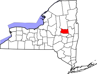
This is intended to be a complete list of properties and districts listed on the National Register of Historic Places in Essex County, New York, United States. The locations of National Register properties and districts (at least for all showing latitude and longitude coordinates below) can be seen in a map by clicking on "Map of all coordinates".[1] Seven of the properties and districts are further designated National Historic Landmarks and are indicated by light blue color in the table below.
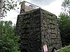
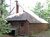
The remains of the "Upper Works" iron foundry that date back to 1826. Iron from the site was contaminated with titanium, which, together with its isolation, made for an unprofitable venture.
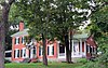
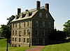
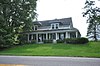
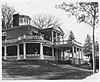
A 2 1⁄2-story brick, gable-roofed historic house and estate built about 1807 in the Georgian style featuring a central Palladian window. Also on the property are a horse barn, tenants' cottage, and five stone lined wells.
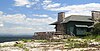
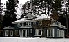
The 1890 clubhouse of the Adirondack Mountain Reserve, which was formed in 1887 to save 25,000 acres (100km2) of the Adirondack High Peaks from lumbering. The Reserve once owned most of the High Peaks; it still owns 7,000 acres (28km2), and provides public access to many high peaks trails.
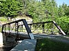
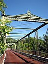
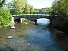
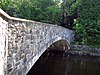
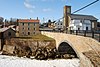
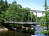
Beer's Bridge is a historic Pratt Pony truss bridge over the Ausable River built in 1900 by the Pratt, Tomas & Caleb Company. The site is part of the AuSable River Valley Bridges Multiple Property Submission (MPS)
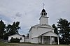
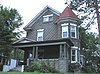
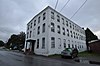
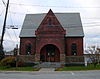
Black Watch Library is a historic library building built in 1905.It is a one-story brick structure with a cruciform plan in the Jacobean Revival style. It features a blue/green slate gable roof with projecting rafter ends.
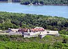
With 131 contributing buildings this late-19th and early-20th century historic district includes vernacular farmhouses in a variety of styles, barn complexes, a stone 1816 schoolhouse, Skenewood Estate, the Stable Inn properties, Germain property, "Kenjockety," Barber's Point Lighthouse, and Camp Dudley, the oldest continuing boy's camp.
Built in 1855 as St. John's Episcopal Church, it became the Union Church at Boquet Chapel in 1880, the Church of the Nazarene in 1949 and Foothills Baptist Church in 2005.[5]
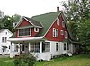
A 1915 large, Tudor-style, 2 and 1/2 story "cure cottage" designed by William H. Scopes. The owner was a civil engineer whose wife had tuberculosis. Part of the Saranac Lake MPS
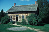
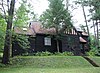
This is a historic "cure cottage" built about 1912. It is a two-story, clapboarded wood frame dwelling on a stone foundation with a steep gable roof with overhanging eaves. It features a second floor cure porch.
A French fort started in 1734 to gain control of the New France/Vermont border region in the Lake Champlain Valley. The walls were twelve feet thick and four stories high, with cannons on each level, manned by over a thousand officers and men.[7]
A large 18th-century fort built by the French starting in 1755 that controlled both commonly used trade routes between the English-controlled Hudson River Valley and the French-controlled Saint Lawrence River Valley. It played a part in the American Revolutionary War.
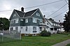
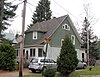
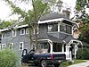
Residential neighborhood from early 20th century, with many cottages retaining the "cure porches" that distinguished the area's early days as a sanitarium.
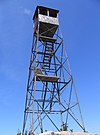
A 35-foot (11m) fire tower built in 1919 on 3,964-foot (1,208m) Hurricane Mountain. Part of the Fire Observation Stations of New York State Forest Preserve MPS
A 1987 "cure cottage" that was used by the National Vaudeville Artists Philanthropic Association prior to the construction of the Will Rogers Hospital. Part of the Saranac Lake MPS
A 1923 "cure cottage" built by Edward Shaw for his wife, who had tuberculosis. The Shaws had two young children; fearing that they would contract TB from Mrs. Shaw, a separate house was built for them, nearby. Part of the Saranac Lake MPS
A 1932 "cure cottage" designed by William L. Distin for Dr. Henry Leetch, who specialized in treating tuberculosis, and who had the disease himself. Part of the Saranac Lake MPS
The Ligonier Point Historic District consists of eight buildings and two dozen contributing structures and sites, related to stone quarrying, boat building, and farming by the Clark family during the 19th century.
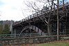
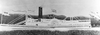
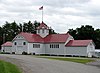
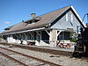
The New York Central Adirondack Line ended in Lake Placid. There are extant stations in Ray Brook and Lake Placid; the Adirondack Scenic Railroad used to run a tourist train between Lake Placid and the station in Saranac Lake.
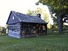
Sheldon–Owens Farm is a historic district set on a property assembled between 1784 and 1945. The oldest structure is a barn dated to the late 18th century. Outbuildings include barns, a granary, brick smokehouse, and sugar house. The farmhouse dates to 1853.
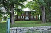
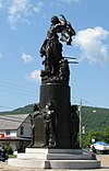
Home of Elkanah Watson, Revolutionary-era diplomat, founder of the county fair and early promoter of canals, who occupied it in May 1828. Designed by Sheldon & Merritt and constructed under the supervision of Watson's son Charles.
List of the National Register of Historic Places listings in Franklin County, New York
List of the National Register of Historic Places listings in Fulton County, New York
List of the National Register of Historic Places listings in Genesee County, New York
List of the National Register of Historic Places listings in Hamilton County, New York
List of the National Register of Historic Places listings in Herkimer County, New York
List of the National Register of Historic Places listings in Livingston County, New York
This is a list of the National Register of Historic Places listings in Erie County, New York.
List of the National Register of Historic Places listings in Putnam County, New York
List of Registered Historic Places in Warren County, New York
List of the National Register of Historic Places listings in Tompkins County, New York
List of the National Register of Historic Places listings in Madison County, New York
Between 1873 and 1945, Saranac Lake, New York, became a world-renowned center for the treatment of tuberculosis, using a treatment that involved exposing patients to as much fresh air as possible under conditions of complete bed-rest. In the process, a specific building type, the "cure cottage", developed, built by residents seeking to capitalize on the town's fame, by physicians, and often by the patients themselves. Many of these structures are extant, and their historic value has been recognized by listing on The National Register of Historic Places.
This is intended to be a complete list of properties and districts listed on the National Register of Historic Places on Manhattan Island below 14th Street, which is a significant portion of the New York City borough of Manhattan. In turn, the borough of Manhattan is coterminous with New York County, New York. For properties and districts in other parts of Manhattan Island, the mainland neighborhood of Marble Hill, and the other islands of New York County, see National Register of Historic Places listings in Manhattan. The locations of National Register properties and districts may be seen in an online map by clicking on "Map of all coordinates".
This is intended to be a complete list of historic properties and districts listed on the National Register of Historic Places located on islands other than Manhattan Island but still in New York County, New York. For all properties and districts in the borough of Manhattan, see National Register of Historic Places listings in New York County, New York. The locations of National Register properties and districts may be seen in an online map by clicking on "Map of all coordinates".
This is a list of the National Register of Historic Places listings in Essex County, Virginia.
This is a list of the National Register of Historic Places listings in Andover, Massachusetts.
The following properties are listed on the National Register of Historic Places in Lawrence, Massachusetts.
This list includes properties and districts listed on the National Register of Historic Places in Brunswick County, North Carolina. Click the "Map of all coordinates" link to the right to view an online map of all properties and districts with latitude and longitude coordinates in the table below.
This is a list of the National Register of Historic Places listings in Salem, Massachusetts.
This is a list of the National Register of Historic Places listings in Ipswich, Massachusetts.
References
↑ The latitude and longitude information provided in this table was derived originally from the National Register Information System, which has been found to be fairly accurate for about 99% of listings. Some locations in this table may have been corrected to current GPS standards.
1 2 Numbers represent an alphabetical ordering by significant words. Various colorings, defined here, differentiate National Historic Landmarks and historic districts from other NRHP buildings, structures, sites or objects.
↑ The eight-digit number below each date is the number assigned to each location in the National Register Information System database, which can be viewed by clicking the number.
This page is based on this Wikipedia article Text is available under the CC BY-SA 4.0 license; additional terms may apply. Images, videos and audio are available under their respective licenses.