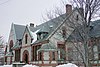
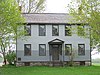
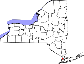
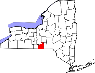
[3] Name on the Register Image Date listed [4] Location City or town Description 1 Henry Allen House Henry Allen House February 24, 1995 (# 95000060 12 E. Cayuga St. 42°42′47″N 76°25′16″W / 42.713056°N 76.421111°W / 42.713056; -76.421111 (Henry Allen House ) Moravia Italianate house built around 1877. 2 Auburn Button Works and Logan Silk Mills Auburn Button Works and Logan Silk Mills September 28, 2007 (# 07001014 9-11 Logan St. 42°55′40″N 76°33′52″W / 42.92774°N 76.56445°W / 42.92774; -76.56445 (Auburn Button Works and Logan Silk Mills ) Auburn Vernacular Italianate industrial buildings. 3 Aurora Steam Grist Mill Aurora Steam Grist Mill July 30, 1976 (# 76001207 Main St. 42°45′15″N 76°42′15″W / 42.754167°N 76.704167°W / 42.754167; -76.704167 (Aurora Steam Grist Mill ) Aurora 4 Aurora Village-Wells College Historic District Aurora Village-Wells College Historic District November 19, 1980 (# 80002595 NY 90 42°45′01″N 76°42′00″W / 42.750278°N 76.7°W / 42.750278; -76.7 (Aurora Village-Wells College Historic District ) Aurora Includes Glen Park, designed by A. J. Davis , with grounds designed by A. J. Downing ; and E. B. Morgan House 5 Belt-Gaskin House Belt-Gaskin House October 5, 2005 (# 05001135 77 Chapman Ave. 42°55′13″N 76°34′33″W / 42.92016°N 76.57575°W / 42.92016; -76.57575 (Belt-Gaskin House ) Auburn Home of African-American families, in succession. The Belts were born in slavery, apparently fled to Canada, came to Auburn after the Civil War. 6 Orrin W. Burritt House Orrin W. Burritt House August 30, 2007 (# 07000864 2696 Van Buren St. 43°02′45″N 76°33′47″W / 43.045833°N 76.563056°W / 43.045833; -76.563056 (Orrin W. Burritt House ) Weedsport 7 Case Memorial-Seymour Library Case Memorial-Seymour Library May 6, 1980 (# 80002594 176 Genesee St. 42°55′44″N 76°34′18″W / 42.928889°N 76.571667°W / 42.928889; -76.571667 (Case Memorial-Seymour Library ) Auburn 8 Cayuga County Courthouse and Clerk's Office Cayuga County Courthouse and Clerk's Office June 21, 1991 (# 91000721 152-154 Genesee St. 42°55′47″N 76°34′09″W / 42.929722°N 76.569167°W / 42.929722; -76.569167 (Cayuga County Courthouse and Clerk's Office ) Auburn 9 Centreport Aqueduct Centreport Aqueduct February 4, 2000 (# 00000051 2462 NY 31 43°02′34″N 76°34′39″W / 43.042778°N 76.5775°W / 43.042778; -76.5775 (Centreport Aqueduct ) Weedsport 10 Church Street-Congress Street Historic District Church Street-Congress Street Historic District February 3, 1994 (# 92001364 Roughly bounded by S. Main, Church, Park and Congress Sts. 42°42′36″N 76°25′07″W / 42.71°N 76.418611°W / 42.71; -76.418611 (Church Street-Congress Street Historic District ) Moravia 11 Cottage Farm Cottage Farm November 21, 2012 (# 12000952 14475 Richmond Ave 43°19′03″N 76°42′16″W / 43.31738°N 76.704388°W / 43.31738; -76.704388 (Cottage Farm ) Fair Haven Cottage built in 1830s in Greek Revival style, later renovated with Victorian style elements. 12 Almeron Durkee House Almeron Durkee House January 5, 2005 (# 04001455 13 Cayuga St. (NY-90 ) 42°50′03″N 76°41′45″W / 42.834167°N 76.695833°W / 42.834167; -76.695833 (Almeron Durkee House ) Union Springs Extremely well-preserved stone house from c.1820, and smokehouse and barn. 13 Charles Chauncey Dwight House Charles Chauncey Dwight House November 17, 2015 (# 15000818 149 North St. 42°56′29″N 76°34′02″W / 42.94148°N 76.56725°W / 42.94148; -76.56725 (Charles Chauncey Dwight House ) Auburn 1835 house renovated in 1871 by Dwight, a Union Army officer and judge 14 East Genoa Methodist Episcopal Church East Genoa Methodist Episcopal Church January 24, 2002 (# 01001500 558 E. Genoa Rd. 42°38′44″N 76°30′19″W / 42.645556°N 76.505278°W / 42.645556; -76.505278 (East Genoa Methodist Episcopal Church ) Genoa 15 Erie Canal Lock 52 Complex Erie Canal Lock 52 Complex September 3, 1998 (# 98001146 Maiden Ln. 43°02′13″N 76°38′06″W / 43.036944°N 76.635°W / 43.036944; -76.635 (Erie Canal Lock 52 Complex ) Port Byron 16 First Baptist Church of Weedsport First Baptist Church of Weedsport December 31, 2002 (# 02001640 Liberty St. 43°02′47″N 76°33′42″W / 43.046389°N 76.561667°W / 43.046389; -76.561667 (First Baptist Church of Weedsport ) Weedsport 17 Former US Post Office and Federal Courthouse Former US Post Office and Federal Courthouse June 11, 1991 (# 91000722 151-157 Genesee St. 42°55′49″N 76°34′12″W / 42.930278°N 76.57°W / 42.930278; -76.57 (Former US Post Office and Federal Courthouse ) Auburn 18 William and Mary Hosmer House William and Mary Hosmer House April 12, 2006 (# 06000262 29 Washington St. 42°55′48″N 76°34′34″W / 42.92991°N 76.57600°W / 42.92991; -76.57600 (William and Mary Hosmer House ) Auburn Home of anti-slavery editor and author 19 House at 15 East Cayuga Street House at 15 East Cayuga Street April 20, 1995 (# 95000472 15 E. Cayuga St. 42°42′49″N 76°25′15″W / 42.713611°N 76.420833°W / 42.713611; -76.420833 (House at 15 East Cayuga Street ) Moravia Italianate-style duplex house. 20 House at 17 Aurora Street House at 17 Aurora Street February 24, 1995 (# 95000057 17 Aurora St. 42°42′37″N 76°25′22″W / 42.71037°N 76.42288°W / 42.71037; -76.42288 (House at 17 Aurora Street ) Moravia House built c.1850 21 House at 18 Aurora Street House at 18 Aurora Street February 24, 1995 (# 95000058 18 Aurora St. 42°42′39″N 76°25′24″W / 42.710833°N 76.423333°W / 42.710833; -76.423333 (House at 18 Aurora Street ) Moravia Two-story, frame Greek Revival style dwelling constructed about 1850. The structure is dominated by its three-bay, side entrance temple front. 22 House at 20 Aurora Street House at 20 Aurora Street February 24, 1995 (# 95000059 20 Aurora St. 42°42′39″N 76°25′24″W / 42.71076°N 76.42323°W / 42.71076; -76.42323 (House at 20 Aurora Street ) Moravia Vernacular frame house built c.1840. 23 House at 21 West Cayuga Street House at 21 West Cayuga Street February 24, 1995 (# 95000103 21 W. Cayuga St. 42°42′49″N 76°25′26″W / 42.71351°N 76.42384°W / 42.71351; -76.42384 (House at 21 West Cayuga Street ) Moravia House from c.1810-1830 in vernacular Federal style. 24 House at 31 West Cayuga Street House at 31 West Cayuga Street February 24, 1995 (# 95000062 31 W. Cayuga 42°42′49″N 76°25′32″W / 42.713611°N 76.425556°W / 42.713611; -76.425556 (House at 31 West Cayuga Street ) Moravia Greek Revival style house 25 House at 36 South Main Street House at 36 South Main Street February 24, 1995 (# 95000064 36 S. Main St. 42°42′28″N 76°25′18″W / 42.707778°N 76.421667°W / 42.707778; -76.421667 (House at 36 South Main Street ) Moravia Queen Anne style house built around 1890, and carriage barn. 26 House at 37 West Cayuga Street House at 37 West Cayuga Street February 24, 1995 (# 95000063 37 W. Cayuga St. 42°42′50″N 76°25′36″W / 42.713889°N 76.426667°W / 42.713889; -76.426667 (House at 37 West Cayuga Street ) Moravia Italianate house, with carriage house (c.1870) 27 House at 46 South Main Street House at 46 South Main Street February 24, 1995 (# 95000065 46 S. Main St. 42°42′25″N 76°25′16″W / 42.70700°N 76.42118°W / 42.70700; -76.42118 (House at 46 South Main Street ) Moravia Italianate house located at what is actually now 63 S. Main St. 28 Howland Cobblestone Store Howland Cobblestone Store March 17, 1994 (# 94000171 N side Sherwood Rd., just E of jct. with Co. Rd. 34B 42°45′40″N 76°37′17″W / 42.761111°N 76.621389°W / 42.761111; -76.621389 (Howland Cobblestone Store ) Scipio 29 Augustus Howland House Augustus Howland House May 20, 2008 (# 08000448 1395 Sherwood Rd. 42°45′37″N 76°38′51″W / 42.7603°N 76.647497°W / 42.7603; -76.647497 (Augustus Howland House ) Sherwood High-style Italianate house from c.1850. 30 Charles Howland-William H. Chase House Charles Howland-William H. Chase House January 5, 2005 (# 04001456 188 Cayuga St. 42°50′39″N 76°41′24″W / 42.84408°N 76.68999°W / 42.84408; -76.68999 (Charles Howland-William H. Chase House ) Union Springs Greek Revival style house built c.1840, set back from Cayuga St. (NY-90 ) 31 Slocum and Hannah Howland House Slocum and Hannah Howland House April 12, 2006 (# 06000263 1781 Sherwood Rd. 42°45′47″N 76°37′21″W / 42.7631°N 76.6225°W / 42.7631; -76.6225 (Slocum and Hannah Howland House ) Sherwood 32 Ezra A. Huntington House Ezra A. Huntington House January 31, 2020 (# 100004914 11 Seminary St. 43°56′09″N 76°33′54″W / 43.9357°N 76.5651°W / 43.9357; -76.5651 (Ezra A. Huntington House ) Auburn 1861 Italianate house of first president of Auburn Theological Seminary 33 Hutchinson Homestead Hutchinson Homestead September 9, 2009 (# 09000478 6080 Lake St. 42°54′44″N 76°43′35″W / 42.91209°N 76.72626°W / 42.91209; -76.72626 (Hutchinson Homestead ) Cayuga Colonial Revival-style house from c.1910. 34 William Smith Ingham House William Smith Ingham House April 6, 2005 (# 05000263 3069 W Main St. 43°09′58″N 76°32′15″W / 43.16624°N 76.53759°W / 43.16624; -76.53759 (William Smith Ingham House ) Meridian Temple-front Greek Revival house from 1835. 35 Lakeside Park Lakeside Park October 30, 1989 (# 89001790 NY 38A at Owasco Lake 42°54′09″N 76°32′14″W / 42.9025°N 76.537222°W / 42.9025; -76.537222 (Lakeside Park ) Owasco Park with carousel building, now a theatre, and other structures and pathways from bygone era. 36 John McGeer House John McGeer House February 24, 1995 (# 95000056 7 Aurora St. 42°42′37″N 76°25′21″W / 42.71041°N 76.42238°W / 42.71041; -76.42238 (John McGeer House ) Moravia Italianate house built in 1871 and wagon shop. 37 Mentz Church Mentz Church September 24, 2004 (# 04001064 Mentz Church Rd. at McDonald Rd. 42°59′53″N 76°40′39″W / 42.998056°N 76.6775°W / 42.998056; -76.6775 (Mentz Church ) Montezuma 38 Moravia Union Cemetery Moravia Union Cemetery November 7, 1995 (# 95001278 NY 38 42°42′07″N 76°25′04″W / 42.701944°N 76.417778°W / 42.701944; -76.417778 (Moravia Union Cemetery ) Moravia Also known as the Dry Creek Cemetery, this can be accessed from the Fillmore Glen park or from behind a school. 39 Morse Farm Morse Farm February 24, 1995 (# 95000067 52 S. Main St. 42°42′23″N 76°25′12″W / 42.70625°N 76.42010°W / 42.70625; -76.42010 (Morse Farm ) Moravia Oldest house in Moravia, and barn 40 Mosher Farmstead Mosher Farmstead December 12, 2003 (# 03001280 1016 Sherwood Rd. 42°45′36″N 76°40′21″W / 42.76°N 76.6725°W / 42.76; -76.6725 (Mosher Farmstead ) Aurora 41 New Hope Mills Complex New Hope Mills Complex March 15, 2005 (# 05000158 Glen Haven Rd. and NY 41A 42°47′55″N 76°20′49″W / 42.798611°N 76.346944°W / 42.798611; -76.346944 (New Hope Mills Complex ) New Hope 42 New York State Barge Canal New York State Barge Canal October 15, 2014 (# 14000860 Linear across county 43°04′14″N 76°33′25″W / 43.070431°N 76.556947°W / 43.070431; -76.556947 (New York State Barge Canal ) Aurelius, Brutus, Cato, Conquest, Mentz, Montezuma Successor to Erie Canal approved by state voters in early 20th century to compete with railroads. 43 North Main Street Historic District North Main Street Historic District February 3, 1993 (# 92001365 N. Main St. and part of Keeler Ave. 42°42′54″N 76°25′19″W / 42.715°N 76.421944°W / 42.715; -76.421944 (North Main Street Historic District ) Moravia Residential historic district of 44 contributing buildings , many of Italianate style built during Moravia's post-Civil War prosperity. 44 North Street Friends Meetinghouse North Street Friends Meetinghouse December 9, 2005 (# 05001386 2960 Brick Church Rd. 42°45′48″N 76°39′04″W / 42.763333°N 76.651111°W / 42.763333; -76.651111 (North Street Friends Meetinghouse ) Ledyard 45 Job and Deborah Otis House Job and Deborah Otis House May 29, 2008 (# 08000468 1882-1886 Sherwood Rd. 42°45′39″N 76°36′55″W / 42.76081°N 76.61515°W / 42.76081; -76.61515 (Job and Deborah Otis House ) Sherwood Federal style house from 1796, and two-story carriage barn. 46 Owasco Reformed Church Owasco Reformed Church April 27, 2010 (# 10000223 5105 Rte 38A (E. Lake Rd.) 42°51′17″N 76°27′55″W / 42.854714°N 76.465239°W / 42.854714; -76.465239 (Owasco Reformed Church ) Owasco 47 William Richardson House William Richardson House March 15, 2005 (# 05000160 5494 Cross Rd. 42°53′03″N 76°40′56″W / 42.88410°N 76.68212°W / 42.88410; -76.68212 (William Richardson House ) Union Springs Late Federal / early Greek Revival house from c.1830. 48 Sager House Sager House February 24, 1995 (# 95000061 12 W. Cayuga St. 42°42′50″N 76°25′24″W / 42.713889°N 76.423333°W / 42.713889; -76.423333 (Sager House ) Moravia Queen Anne style house built in 1884 49 St. Peter's Episcopal Church Complex St. Peter's Episcopal Church Complex January 24, 2002 (# 01001508 169 Genesee St. 42°55′47″N 76°34′18″W / 42.929722°N 76.571667°W / 42.929722; -76.571667 (St. Peter's Episcopal Church Complex ) Auburn 50 Sand Beach Church Sand Beach Church June 10, 1975 (# 75001176 S of Auburn on NY 38 42°54′12″N 76°32′49″W / 42.90337°N 76.54704°W / 42.90337; -76.54704 (Sand Beach Church ) Auburn Vernacular Romanesque Revival church 51 Schines Auburn Theatre Schines Auburn Theatre March 15, 2000 (# 94001333 12-14 South St. 42°55′52″N 76°33′56″W / 42.931111°N 76.565556°W / 42.931111; -76.565556 (Schines Auburn Theatre ) Auburn 52 Seneca River Crossing Canals Historic District Seneca River Crossing Canals Historic District December 9, 2005 (# 05001397 Off NY 90 43°00′32″N 76°42′45″W / 43.008889°N 76.7125°W / 43.008889; -76.7125 (Seneca River Crossing Canals Historic District ) Montezuma Extends into Tyre in Seneca County. 53 Sennett Federated Church and Parsonage Sennett Federated Church and Parsonage October 5, 2005 (# 05001130 777 Weedsport-Sennett Rd. 42°59′45″N 76°32′01″W / 42.995833°N 76.533611°W / 42.995833; -76.533611 (Sennett Federated Church and Parsonage ) Sennett Church built in 1848 for a Congregationalist following, later becoming church for unified Baptist and Congregational churches of the hamlet of Sennett. 54 William H. Seward House William H. Seward House October 15, 1966 (# 66000504 33 South St. 42°55′33″N 76°33′59″W / 42.925833°N 76.566389°W / 42.925833; -76.566389 (William H. Seward House ) Auburn 55 Sherwood Equal Rights Historic District Sherwood Equal Rights Historic District February 29, 2008 (# 08000096 Sherwood Rd. & NY 34B 42°45′40″N 76°37′17″W / 42.761025°N 76.621375°W / 42.761025; -76.621375 (Sherwood Equal Rights Historic District ) Sherwood 56 South Street Area Historic District South Street Area Historic District March 9, 1991 (# 91000109 Roughly, South St. and adjacent properties from Metcalf Dr. to Lincoln St. 42°55′47″N 76°33′45″W / 42.929722°N 76.5625°W / 42.929722; -76.5625 (South Street Area Historic District ) Auburn 57 Sterling District No. 5 Schoolhouse Sterling District No. 5 Schoolhouse October 10, 2002 (# 02001119 NY104A 43°19′25″N 76°38′51″W / 43.323611°N 76.6475°W / 43.323611; -76.6475 (Sterling District No. 5 Schoolhouse ) Sterling Schoolhouse built around 1853, now the Sterling Historical Society Museum. 58 Sterling Grist Mill Complex Sterling Grist Mill Complex January 24, 2002 (# 01001498 1332 NY 104A 43°19′31″N 76°38′49″W / 43.325278°N 76.646944°W / 43.325278; -76.646944 (Sterling Grist Mill Complex ) Sterling Frame mill building built about 1835, rubble foundation of an 1859 tannery, and a dam and penstock built about 1900. 59 Thompson AME Zion Church Thompson AME Zion Church April 2, 1999 (# 99000349 33 Parker St. 42°55′24″N 76°34′34″W / 42.923333°N 76.576111°W / 42.923333; -76.576111 (Thompson AME Zion Church ) Auburn Part of a National Historic Landmark 60 Frank and Eliza Tryon House Frank and Eliza Tryon House May 19, 2014 (# 14000223 8976 N. Seneca St. 43°03′07″N 76°33′38″W / 43.05197°N 76.5606°W / 43.05197; -76.5606 (Frank and Eliza Tryon House ) Weedsport 61 Harriet Tubman Grave Harriet Tubman Grave April 2, 1999 (# 99000348 Fort Hill Cemetery 42°55′29″N 76°34′29″W / 42.924722°N 76.574722°W / 42.924722; -76.574722 (Harriet Tubman Grave ) Auburn 62 Harriet Tubman Home for the Aged Harriet Tubman Home for the Aged May 30, 1974 (# 74001222 180-182 South St. 42°54′40″N 76°34′04″W / 42.911111°N 76.567778°W / 42.911111; -76.567778 (Harriet Tubman Home for the Aged ) Auburn 63 Harriet Tubman House Harriet Tubman House April 2, 1999 (# 99000347 182 South St. 42°54′40″N 76°33′42″W / 42.911111°N 76.561667°W / 42.911111; -76.561667 (Harriet Tubman House ) Auburn Part of a National Historic Landmark 64 Tuthill-Green House Tuthill-Green House February 24, 1995 (# 95000066 59 S. Main St. 42°42′23″N 76°25′16″W / 42.70644°N 76.42116°W / 42.70644; -76.42116 (Tuthill-Green House ) Moravia Ornate house built c.1887, with carriage house. 65 Wall Street Methodist Episcopal Church Wall Street Methodist Episcopal Church April 29, 1999 (# 99000507 69 Wall St. 42°56′07″N 76°34′43″W / 42.935278°N 76.578611°W / 42.935278; -76.578611 (Wall Street Methodist Episcopal Church ) Auburn 66 West High School West High School August 18, 2017 (# 100001484 217 Genesee St. 42°55′34″N 76°34′42″W / 42.926212°N 76.578376°W / 42.926212; -76.578376 (West High School ) Auburn 1938-constructed building for industrial arts-focused high school 67 Willard Memorial Chapel-Welch Memorial Hall Willard Memorial Chapel-Welch Memorial Hall June 8, 1989 (# 89000461 17-19 Nelson St. 42°56′14″N 76°33′48″W / 42.937222°N 76.563333°W / 42.937222; -76.563333 (Willard Memorial Chapel-Welch Memorial Hall ) Auburn 68 Dr. Sylvester Willard Mansion Dr. Sylvester Willard Mansion November 13, 1989 (# 89001948 203 W. Genesee St. 42°55′39″N 76°34′30″W / 42.9275°N 76.575°W / 42.9275; -76.575 (Dr. Sylvester Willard Mansion ) Auburn 69 Jethro Wood House Jethro Wood House October 15, 1966 (# 66000505 NY 34B 42°44′15″N 76°37′57″W / 42.7375°N 76.6325°W / 42.7375; -76.6325 (Jethro Wood House ) Poplar Ridge Home of inventor of iron plow 70 Peter Yawger House Peter Yawger House April 15, 2004 (# 04000283 NY 90 42°53′25″N 76°42′25″W / 42.89026°N 76.70681°W / 42.89026; -76.70681 (Peter Yawger House ) North of Union Springs Spectacular Greek Revival-style house on NY-90.