National Register of Historic Places listings in Putnam County, New York

Last updated

Location of Putnam County in New York Map of New York highlighting Putnam County.svg
Location of Putnam County in New York
Map all coordinates using: OpenStreetMap  
Download coordinates as: KML

List of the National Register of Historic Places listings in Putnam County, New York

Contents

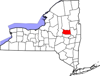
This is intended to be a complete list of properties and districts listed on the National Register of Historic Places in Putnam County, New York. The locations of National Register properties and districts (at least for all showing latitude and longitude coordinates below) may be seen in a map by clicking on "Map of all coordinates". [1] Two properties are further designated as National Historic Landmarks of the United States.


    This National Park Service list is complete through NPS recent listings posted April 14, 2023. [2]

Contents: Counties in New York
Albany (Albany)AlleganyBronxBroomeCattaraugusCayugaChautauquaChemungChenangoClintonColumbiaCortlandDelawareDutchess (Poughkeepsie, Rhinebeck)Erie (Buffalo)EssexFranklinFultonGeneseeGreeneHamiltonHerkimerJeffersonKingsLewisLivingstonMadisonMonroe (Rochester)MontgomeryNassauNew York (Below 14th Street, 14th to 59th Streets, 59th to 110th Streets, Above 110th Street, Islands)Niagara (Niagara Falls)OneidaOnondaga (Syracuse)OntarioOrangeOrleansOswegoOtsegoPutnamQueensRensselaerRichmondRocklandSt. LawrenceSaratogaSchenectadySchoharieSchuylerSenecaSteubenSuffolkSullivanTiogaTompkinsUlsterWarrenWashingtonWayneWestchester (Northern, Southern, New Rochelle, Peekskill, Yonkers)WyomingYates

Listings county-wide

[3] Name on the RegisterImageDate listed [4] Location City or townDescription
1 The Birches
The Birches The Birches, Garrison, NY.jpg
The Birches
November 23, 1982
(#82001259)
Cat Rock Rd.
41°22′31″N73°56′38″W / 41.375278°N 73.943889°W / 41.375278; -73.943889 (The Birches)
Garrison 1882 Victorian Gothic house designed for Illinois Central president William Osborn; used as honeymoon house by both his sons. One of Ralph Adams Cram's earliest works
2 Boscobel
Boscobel Boscobel, Garrison, NY - front facade.jpg
Boscobel
November 7, 1977
(#77000971)
N of Garrison on NY 9D
41°24′39″N73°56′22″W / 41.410833°N 73.939444°W / 41.410833; -73.939444 (Boscobel)
Garrison Outstanding example of Federal style mansion, built by States Dyckman in 1808, with many original furnishings. Moved upriver from original site at Montrose and restored after several years in state storage when FDR Veterans Hospital was built on original site.
3 Walter Brewster House
Walter Brewster House Walter Brewster House.jpg
Walter Brewster House
October 4, 1978
(#78001896)
Oak St.
41°23′42″N73°36′59″W / 41.395°N 73.616389°W / 41.395; -73.616389 (Walter Brewster House)
Brewster Home of village founder; only Greek Revival home in county with a two-story colonnade
4 Castle Rock
Castle Rock Castle Rock, Garrison, NY.jpg
Castle Rock
December 12, 1977
(#77000972)
NY 9D
41°22′06″N73°56′28″W / 41.368333°N 73.941111°W / 41.368333; -73.941111 (Castle Rock)
Garrison Eclectic mountaintop estate built by J. Morgan Slade for William Osborn in 1881; a major Hudson Highlands landmark ever since
5 H. D. Champlin & Son Horseshoeing and Wagonmaking
H. D. Champlin & Son Horseshoeing and Wagonmaking HD Champlin store.jpg
H. D. Champlin & Son Horseshoeing and Wagonmaking
November 23, 1982
(#82001234)
286 Main St.
41°25′29″N73°56′49″W / 41.424722°N 73.946944°W / 41.424722; -73.946944 (H. D. Champlin & Son Horseshoeing and Wagonmaking)
Nelsonville Late 19th-century commercial structure preserved nearly intact
6 Cold Spring Cemetery Gatehouse
Cold Spring Cemetery Gatehouse Cold Spring Cemetery Gatehouse.jpg
Cold Spring Cemetery Gatehouse
November 23, 1982
(#82001236)
Peekskill Rd.
41°25′20″N73°56′41″W / 41.422222°N 73.944722°W / 41.422222; -73.944722 (Cold Spring Cemetery Gatehouse)
Nelsonville 1862 Gothic Revival gatehouse with unusual roof styling; one of the earliest uses of that style in the Highlands
7 Cold Spring Historic District
Cold Spring Historic District Main Street, Cold Spring NY.jpg
Cold Spring Historic District
November 23, 1982
(#82001235)
Roughly Main, Fair, Chestnut Sts., and Paulding Ave.
41°25′04″N73°57′15″W / 41.417778°N 73.954167°W / 41.417778; -73.954167 (Cold Spring Historic District)
Cold Spring Well-preserved core of late 19th-century riverside town
8 DeRham Farm
DeRham Farm DeRham Farm main house, Garrison, NY.jpg
DeRham Farm
March 28, 1980
(#80002750)
N of Garrison on Indian Brook Rd.
41°24′20″N73°56′12″W / 41.405556°N 73.936667°W / 41.405556; -73.936667 (DeRham Farm)
Garrison Early 19th-century gentleman farmer's complex on Hudson
9 J. Y. Dykman Flour and Feed Store
J. Y. Dykman Flour and Feed Store JY Dykman Flour and Feed Store.jpg
J. Y. Dykman Flour and Feed Store
November 23, 1982
(#82001237)
289 Main St.
41°25′28″N73°56′48″W / 41.424444°N 73.946667°W / 41.424444; -73.946667 (J. Y. Dykman Flour and Feed Store)
Nelsonville Most ornate commercial building in Nelsonville, dating to mid-19th century
10 J. Y. Dykman Store
J. Y. Dykman Store JY Dykman Store.jpg
J. Y. Dykman Store
November 23, 1982
(#82001238)
255 Main St.
41°25′24″N73°56′57″W / 41.423333°N 73.949167°W / 41.423333; -73.949167 (J. Y. Dykman Store)
Nelsonville Ornate facade on ca. 1890 building now used as antique map store
11 Eagle's Rest
Eagle's Rest Eagle's Rest main house, Garrison, NY.jpg
Eagle's Rest
November 23, 1982
(#82001239)
NY 9-D
41°23′46″N73°56′14″W / 41.396111°N 73.937222°W / 41.396111; -73.937222 (Eagle's Rest)
Philipstown Former estate of New York Yankees' owner Jacob Ruppert; now Saint Basil Academy
12 Fair Lawn November 23, 1982
(#82001240)
NY 9-D
41°24′56″N73°56′37″W / 41.415556°N 73.943611°W / 41.415556; -73.943611 (Fair Lawn)
Cold Spring 1860 home built for painter Thomas Prichard Rossiter; later modified by others.
13 First Baptist Church of Cold Spring
First Baptist Church of Cold Spring First Baptist Church of Cold Spring, NY.jpg
First Baptist Church of Cold Spring
November 23, 1982
(#82001241)
Main St.
41°25′22″N73°56′59″W / 41.422778°N 73.949722°W / 41.422778; -73.949722 (First Baptist Church of Cold Spring)
Nelsonville Built in 1833; oldest church building in Philipstown and only frame church in Hudson Highlands
14 First National Bank of Brewster
First National Bank of Brewster First National Bank of Brewster.jpg
First National Bank of Brewster
January 7, 1988
(#87002277)
Main St.
41°23′40″N73°37′10″W / 41.394444°N 73.619444°W / 41.394444; -73.619444 (First National Bank of Brewster)
Brewster Intact Queen Anne-style building from late 19th century later used as by Southeast town hall; still home to some town departments
15 Fish and Fur Club
Fish and Fur Club Fish and Fur Club.jpg
Fish and Fur Club
November 23, 1982
(#82001242)
258 Main St.
41°25′26″N73°56′56″W / 41.423889°N 73.948889°W / 41.423889; -73.948889 (Fish and Fur Club)
Nelsonville 1905 rustic sportsmen's clubhouse is now Nelsonville Village Hall
16 Garrison Grist Mill Historic District
Garrison Grist Mill Historic District Garrison Grist Mill cottage.jpg
Garrison Grist Mill Historic District
December 23, 1993
(#93001434)
Jct. of NY 9D and Lower Station Rd.
41°22′30″N73°56′46″W / 41.375°N 73.946111°W / 41.375; -73.946111 (Garrison Grist Mill Historic District)
Garrison Four colonial-era buildings, among the oldest in Garrison, preserved amid a golf course
17 Garrison Landing Historic District
Garrison Landing Historic District Garrison Landing, NY.jpg
Garrison Landing Historic District
November 23, 1982
(#82001243)
Bounded by Hudson River and NY Central RR Tracks
41°22′58″N73°56′52″W / 41.382778°N 73.947778°W / 41.382778; -73.947778 (Garrison Landing Historic District)
Garrison Mid-19th century commercial area by train station; used for Gay Nineties Yonkers in 1969 film version of Hello, Dolly
18 Garrison Union Free School
Garrison Union Free School Garrison Union Free School.jpg
Garrison Union Free School
November 23, 1982
(#82001244)
NY 9-D
41°22′49″N73°56′20″W / 41.380278°N 73.938889°W / 41.380278; -73.938889 (Garrison Union Free School)
Garrison K-8 school built of local stone in 1908 to house public school that dates to 1793
19 Gilead Cemetery
Gilead Cemetery Gilead Cemetery gates, Carmel, NY.jpg
Gilead Cemetery
December 1, 1988
(#88002684)
Mechanic St.
41°24′30″N73°40′25″W / 41.408333°N 73.673611°W / 41.408333; -73.673611 (Gilead Cemetery)
Carmel A century and a half of graves dating from mid-18th century, including Revolutionary War spy Enoch Crosby and politician Joel Frost; unusually large collection of funerary art illustrates changes in Protestant view of death.
20 Glenfields
Glenfields Glenfields, Garrison, NY.jpg
Glenfields
November 23, 1982
(#82001245)
Old Manitou Rd.
41°21′03″N73°57′12″W / 41.350833°N 73.953333°W / 41.350833; -73.953333 (Glenfields)
Philipstown Ca. 1870 estate of Archibald Gracie King, designed by Cornwall firm Mead and Taft
21 The Grove
The Grove The Grove, Cold Spring, NY, front left view.jpg
The Grove
November 21, 2008
(#08001080)
12 Grove Ct.
41°25′08″N73°57′00″W / 41.4189°N 73.9501°W / 41.4189; -73.9501 (The Grove)
Cold Spring 1853 Richard Upjohn house for Cold Spring Foundry surgeon, later founder of American Medical Association
22 House at 249 Main Street
House at 249 Main Street House at 249 Main Street, Nelsonville, NY, 2013.jpg
House at 249 Main Street
July 31, 1989
(#82005382)
249 Main St.
41°25′24″N73°56′58″W / 41.423333°N 73.949444°W / 41.423333; -73.949444 (House at 249 Main Street)
Nelsonville Ca. 1870 home combines Italianate and Carpenter Gothic design elements
23 House at 3 Crown Street
House at 3 Crown Street House at 3 Crown Street, Nelsonville, NY.jpg
House at 3 Crown Street
November 23, 1982
(#82001246)
3 Crown St.
41°25′26″N73°57′01″W / 41.423889°N 73.950278°W / 41.423889; -73.950278 (House at 3 Crown Street)
Nelsonville Sophisticated 1868 Italianate brick residence
24 Hurst-Pierrepont Estate November 23, 1982
(#82001247)
NY 9-D
41°22′45″N73°56′19″W / 41.379167°N 73.938611°W / 41.379167; -73.938611 (Hurst-Pierrepont Estate)
Garrison
25 Hustis House
Hustis House Hustis House, Nelsonville, NY.jpg
Hustis House
November 23, 1982
(#82001248)
328 Main St.
41°25′37″N73°56′32″W / 41.426944°N 73.942222°W / 41.426944; -73.942222 (Hustis House)
Nelsonville Intact late 19th-century foundry worker housing
26 Indian Brook Road Historic District
Indian Brook Road Historic District Indian Brook Road, Garrison, NY.jpg
Indian Brook Road Historic District
August 19, 1993
(#93000853)
Jct. of Indian Brook Rd. and US 9
41°24′55″N73°54′54″W / 41.415278°N 73.915°W / 41.415278; -73.915 (Indian Brook Road Historic District)
Garrison Former rural hamlet of Nelson's Corner, one of the few pre-industrial ones with its plan and buildings largely intact
27 Mandeville House
Mandeville House Mandeville House, Garrison, NY.jpg
Mandeville House
November 23, 1982
(#82001251)
Lower Station Rd.
41°22′36″N73°56′43″W / 41.376667°N 73.945278°W / 41.376667; -73.945278 (Mandeville House)
Philipstown 
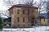
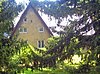
Built in 1735; oldest house in Garrison. Used as headquarters by Israel Putnam during Revolution; later home to Richard Upjohn, whose Gothic changes were mostly removed in the 1920s.
28 Manitoga
Manitoga Dragon Rock, Manitoga, 2009.jpg
Manitoga
November 15, 1996
(#96001269)
Jct. of NY 9D and Manitou Rd.
41°20′50″N73°58′52″W / 41.347222°N 73.981111°W / 41.347222; -73.981111 (Manitoga)
Garrison 
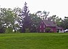
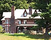
Estate of 20th-century industrial designer Russel Wright features house designed to be sustainable and blend into landscape; one of the earliest American houses to do so.
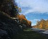
29 Montrest
Montrest Montrest, Nelsonville, NY.jpg
Montrest
November 23, 1982
(#82001252)
Lane Gate Rd.
41°25′43″N73°56′07″W / 41.428611°N 73.935278°W / 41.428611; -73.935278 (Montrest)
Philipstown 1868 summer home of New York City art dealer
30 Moore House November 23, 1982
(#82001249)
Nelson Ln.
41°22′49″N73°56′16″W / 41.380278°N 73.937778°W / 41.380278; -73.937778 (Moore House)
Garrison
31 Normandy Grange
Normandy Grange Normandy Grange, Garrison, NY.jpg
Normandy Grange
November 23, 1982
(#82001250)
NY 9-D
41°23′31″N73°55′53″W / 41.391944°N 73.931389°W / 41.391944; -73.931389 (Normandy Grange)
Philipstown Evans Dick liked this 1905 Norman-style gatehouse complex to his never-completed nearby estate more than the estate itself.
32 Old Albany Post Road
Old Albany Post Road Old Albany Post Road.jpg
Old Albany Post Road
July 8, 1982
(#82003396)
Off US 9
41°20′27″N73°54′16″W / 41.340833°N 73.904444°W / 41.340833; -73.904444 (Old Albany Post Road)
Philipstown Unpaved 6.6-mile (10.6 km) section of original Albany Post Road, with original mileposts, dating to mid-17th century. One of the oldest dirt roads still in use in the U.S.
33 Old Southeast Church
Old Southeast Church Old Southeast Church, Southeast, NY.jpg
Old Southeast Church
July 24, 1972
(#72000903)
N of Brewster on NY 22 off Putnam Lake Rd.
41°25′53″N73°34′29″W / 41.431389°N 73.574722°W / 41.431389; -73.574722 (Old Southeast Church)
Brewster 1794 church, renovated after 1830, is one of the few remaining buildings from Doanesville, commercial center of eastern county prior to railroad
34 Old Southeast Town Hall
Old Southeast Town Hall Old Southeast Town Hall.jpg
Old Southeast Town Hall
July 24, 1979
(#79001619)
Main St.
41°23′39″N73°37′04″W / 41.394167°N 73.617778°W / 41.394167; -73.617778 (Old Southeast Town Hall)
Brewster Early yet mature Colonial Revival building with Moorish Revival touches with theatre upstairs; used today by town and community groups.
35 Oulagisket November 23, 1982
(#82001253)
NY 9-D
41°22′34″N73°56′10″W / 41.376111°N 73.936111°W / 41.376111; -73.936111 (Oulagisket)
Philipstown
36 Plumbush
Plumbush Plumbush.jpg
Plumbush
January 30, 1992
(#82005386)
NY 9D between Peekskill and Moffet Rds.
41°25′08″N73°56′32″W / 41.418889°N 73.942222°W / 41.418889; -73.942222 (Plumbush)
Philipstown Home of Robert Parker Parrott, inventor of the Parrott gun
37 Putnam County Courthouse
Putnam County Courthouse PC Courthouse 800.jpg
Putnam County Courthouse
August 11, 1976
(#76001264)
At jct. of NY 52 and NY 301
41°25′34″N73°40′44″W / 41.426111°N 73.678889°W / 41.426111; -73.678889 (Putnam County Courthouse)
Carmel 1814 courthouse, still used for some court offices, is second-oldest county courthouse in state still in use
38 Reed Memorial Library
Reed Memorial Library Reed Memorial Library, Carmel, NY.jpg
Reed Memorial Library
March 28, 1980
(#80002749)
2 Brewster Ave.
41°25′19″N73°40′42″W / 41.421944°N 73.678333°W / 41.421944; -73.678333 (Reed Memorial Library)
Carmel Stone Tudorbethan building erected in memory of local construction executive and benefactor; oldest library building in county
39 Rock Lawn and Carriage House
Rock Lawn and Carriage House Rock Lawn front facade closeup.jpg
Rock Lawn and Carriage House
November 23, 1982
(#82001254)
Upper Station Rd
41°22′51″N73°56′41″W / 41.380833°N 73.944722°W / 41.380833; -73.944722 (Rock Lawn and Carriage House)
Garrison 1853 Richard Upjohn house is his only Italian Villa-style house in the Hudson Highlands. Hamilton Fish II resided there in late 19th century.
40 St. Andrew's Episcopal Church
St. Andrew's Episcopal Church St Andrew's Episcopal Church, Brewster, NY.jpg
St. Andrew's Episcopal Church
November 23, 1998
(#98001427)
26 Prospect St.
41°23′51″N73°37′02″W / 41.3975°N 73.617222°W / 41.3975; -73.617222 (St. Andrew's Episcopal Church)
Brewster 1903 Gothic Revival church built with donation from wealthy local benefactor; only stone church in eastern Putnam County
41 St. Philip's Church in the Highlands
St. Philip's Church in the Highlands St Philip's Church of the Highlands.jpg
St. Philip's Church in the Highlands
October 11, 1995
(#82005391)
NY 9D
41°22′55″N73°56′23″W / 41.381944°N 73.939722°W / 41.381944; -73.939722 (St. Philip's Church in the Highlands)
Garrison 
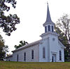
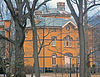
1850 Richard Upjohn-designed church; second on site where congregation dates to the 1760s. Earlier church supposedly saved from destruction by Patriot mob through personal intervention of George Washington
42 Taconic State Parkway
Taconic State Parkway Taconic State Parkway4.jpg
Taconic State Parkway
December 9, 2005
(#05001398)
Linear north-south across center of county
41°24′30″N73°47′13″W / 41.408204°N 73.786806°W / 41.408204; -73.786806 (Taconic State Parkway)
Putnam Valley, Carmel, Kent Scenic divided highway planned by Franklin D. Roosevelt for state park access. Built between the 1920s and early 1960s, epitomizing peak period of parkway design. Extends through Columbia, Dutchess and Westchester counties as well.
43 Walter Thompson House and Carriage House
Walter Thompson House and Carriage House Walter Thompson House Philipstown NY 02.jpg
Walter Thompson House and Carriage House
November 23, 1982
(#82001255)
Snake Hill Rd.
41°23′01″N73°55′56″W / 41.383611°N 73.932222°W / 41.383611; -73.932222 (Walter Thompson House and Carriage House)
Philipstown
44 Tompkins Corners United Methodist Church
Tompkins Corners United Methodist Church Tompkins Corners United Methodist Church, Putnam Valley, NY.jpg
Tompkins Corners United Methodist Church
March 31, 1983
(#83001759)
Peekskill Hollow Rd.
41°24′00″N73°48′06″W / 41.4°N 73.801667°W / 41.4; -73.801667 (Tompkins Corners United Methodist Church)
Putnam Valley 1891 church built for one of the oldest Methodist congregations in the region has unusual L shape as a result of being built on old church's foundation.
45 U.S. Military Academy
U.S. Military Academy SR01 032.jpg
U.S. Military Academy
October 15, 1966
(#66000562)
NY 218
41°23′43″N73°58′18″W / 41.395278°N 73.971667°W / 41.395278; -73.971667 (U.S. Military Academy)
West Point Oldest continuously-operated military post in U.S., and alma mater of many notable American generals and Army officers.
46 Valhalla Highlands Historic District November 12, 2014
(#14000915)
Roughly Highland Rd., Locust, Lookout & Mountainview Drs.
41°28′44″N73°55′40″W / 41.478862°N 73.9278007°W / 41.478862; -73.9278007 (Valhalla Highlands Historic District)
Cold Spring vicinityVacation community established by German/Austrian and Norwegian communities from New York City with many fine rustic wood and stone houses.
47 Walker House
Walker House Walker House, Garrison, NY.jpg
Walker House
November 23, 1982
(#82001256)
Cat Rock Rd.
41°22′23″N73°56′02″W / 41.373056°N 73.933889°W / 41.373056; -73.933889 (Walker House)
Garrison 1890 Queen Anne given by rail magnate Samuel Sloan to his daughter
48 West Point Foundry
West Point Foundry West Point Foundry office.jpg
West Point Foundry
April 11, 1973
(#73001250)
Foundry Cove between NY 90 and NY Central RR tracks
41°24′51″N73°57′12″W / 41.414167°N 73.953333°W / 41.414167; -73.953333 (West Point Foundry)
Cold Spring Makers of cannon for U.S. Army through 19th century; director was Robert Parrott. Major reason for growth of Cold Spring and Nelsonville
49 West Point Foundry Archeological Site February 25, 2010
(#10000059)
Kemble Ave.
41°24′51″N73°57′11″W / 41.4143°N 73.953°W / 41.4143; -73.953 (West Point Foundry Archeological Site)
Cold Spring Designated a National Historic Landmark in 2021.
50 Wilson House
Wilson House Wilson House, Garrison, NY.jpg
Wilson House
November 23, 1982
(#82001257)
Lower Station Rd.
41°22′35″N73°56′50″W / 41.376389°N 73.947222°W / 41.376389; -73.947222 (Wilson House)
Garrison Mid-19th century cottage has finest Carpenter Gothic detailing in the Hudson Highlands
51 Woodlawn
Woodlawn Woodlawn, Garrison, NY.jpg
Woodlawn
November 23, 1982
(#82001258)
NY 9-D
41°23′28″N73°56′16″W / 41.391111°N 73.937778°W / 41.391111; -73.937778 (Woodlawn)
Garrison 1854 Richard Upjohn estate house on river, later used as school and now home of the Hastings Center

See also

Related Research Articles

<span class="mw-page-title-main">National Register of Historic Places listings in Fulton County, New York</span>

List of the National Register of Historic Places listings in Fulton County, New York

<span class="mw-page-title-main">National Register of Historic Places listings in Genesee County, New York</span>

List of the National Register of Historic Places listings in Genesee County, New York

<span class="mw-page-title-main">National Register of Historic Places listings in Hamilton County, New York</span>

List of the National Register of Historic Places listings in Hamilton County, New York

<span class="mw-page-title-main">National Register of Historic Places listings in Lewis County, New York</span>

List of the National Register of Historic Places listings in Lewis County, New York

<span class="mw-page-title-main">National Register of Historic Places listings in Livingston County, New York</span>

List of the National Register of Historic Places listings in Livingston County, New York

<span class="mw-page-title-main">National Register of Historic Places listings in Montgomery County, New York</span>

List of the National Register of Historic Places listings in Montgomery County, New York

<span class="mw-page-title-main">National Register of Historic Places listings in Niagara County, New York</span>

This is a list of the National Register of Historic Places listings in Erie County, New York.

<span class="mw-page-title-main">National Register of Historic Places listings in Oneida County, New York</span>

List of the National Register of Historic Places listings in Oneida County, New York

<span class="mw-page-title-main">National Register of Historic Places listings in Ontario County, New York</span>

List of the National Register of Historic Places listings in Ontario County, New York

<span class="mw-page-title-main">National Register of Historic Places listings in Oswego County, New York</span>

List of the National Register of Historic Places listings in Oswego County, New York

<span class="mw-page-title-main">National Register of Historic Places listings in Saratoga County, New York</span>

List of the National Register of Historic Places listings in Saratoga County, New York

<span class="mw-page-title-main">National Register of Historic Places listings in Schuyler County, New York</span>

List of the National Register of Historic Places listings in Schuyler County, New York

<span class="mw-page-title-main">National Register of Historic Places listings in Seneca County, New York</span>

List of Registered Historic Places in Seneca County, New York

<span class="mw-page-title-main">National Register of Historic Places listings in Washington County, New York</span>

List of the National Register of Historic Places listings in Washington County, New York

<span class="mw-page-title-main">National Register of Historic Places listings in Tompkins County, New York</span>

List of the National Register of Historic Places listings in Tompkins County, New York

<span class="mw-page-title-main">National Register of Historic Places listings in Madison County, New York</span>

List of the National Register of Historic Places listings in Madison County, New York

<span class="mw-page-title-main">National Register of Historic Places listings in Putnam County, Florida</span>

This is a list of the National Register of Historic Places listings in Putnam County, Florida.

This is intended to be a complete list of historic properties and districts listed on the National Register of Historic Places located on islands other than Manhattan Island but still in New York County, New York. For all properties and districts in the borough of Manhattan, see National Register of Historic Places listings in New York County, New York. The locations of National Register properties and districts may be seen in an online map by clicking on "Map of all coordinates".

<span class="mw-page-title-main">National Register of Historic Places listings in Putnam County, Ohio</span>

This is a list of the National Register of Historic Places listings in Putnam County, Ohio.

<span class="mw-page-title-main">National Register of Historic Places listings in Putnam County, West Virginia</span>

This is a list of the National Register of Historic Places listings in Putnam County, West Virginia.

References

  1. The latitude and longitude information provided in this table was derived originally from the National Register Information System, which has been found to be fairly accurate for about 99% of listings. Some locations in this table may have been corrected to current GPS standards.
  2. National Park Service, United States Department of the Interior, "National Register of Historic Places: Weekly List Actions", retrieved April 14, 2023.
  3. Numbers represent an alphabetical ordering by significant words. Various colorings, defined here, differentiate National Historic Landmarks and historic districts from other NRHP buildings, structures, sites or objects.
  4. The eight-digit number below each date is the number assigned to each location in the National Register Information System database, which can be viewed by clicking the number.