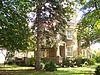
[3] Name on the Register Image Date listed [4] Location City or town Description 1 Adams-Ryan House Adams-Ryan House September 5, 1985 (# 85001957 425 Washington St. 43°11′46″N 77°51′17″W / 43.196111°N 77.854722°W / 43.196111; -77.854722 (Adams-Ryan House ) Adams Basin 2 Adsit Cobblestone Farmhouse Adsit Cobblestone Farmhouse November 29, 1996 (# 96001393 3871 Clover St. 43°00′51″N 77°35′05″W / 43.014167°N 77.584722°W / 43.014167; -77.584722 (Adsit Cobblestone Farmhouse ) Mendon Federal style cobblestone farmhouse from c.1832. Operated as an inn during the mid-19th century, it was used by farmers delivering grain on the road from Canandaigua to Rochester . [5] 3 Alcoa Care-free Home Alcoa Care-free Home June 18, 2010 (# 10000358 1589 Clover St. 43°07′39″N 77°32′49″W / 43.1274°N 77.547019°W / 43.1274; -77.547019 (Alcoa Care-free Home ) Brighton 4 Antoinette Louisa Brown Blackwell Childhood Home Antoinette Louisa Brown Blackwell Childhood Home November 16, 1989 (# 89002003 1099 Pinnacle Rd. 43°03′05″N 77°36′00″W / 43.051389°N 77.6°W / 43.051389; -77.6 (Antoinette Louisa Brown Blackwell Childhood Home ) Henrietta 5 Brockport Cemetery Brockport Cemetery March 8, 2016 (# 16000061 56-98 High St. 43°12′39″N 77°56′02″W / 43.2107°N 77.9338°W / 43.2107; -77.9338 (Brockport Cemetery ) Brockport Community's primary burial ground for most of the 19th century 6 Brockport Central Rural High School Brockport Central Rural High School November 10, 2011 (# 11000805 40 Allen St. 43°12′26″N 77°56′51″W / 43.207294°N 77.947447°W / 43.207294; -77.947447 (Brockport Central Rural High School ) Brockport 7 Brockport West Side Historic District Upload image February 12, 2021 (# 100006145 Portions of Main, Holley, Utica, College, Maxon, Adams, Mercer, Allen, Chappell Sts., Centennial Ave., Brockway Pl., and Monroe Ave. 43°12′43″N 77°56′30″W / 43.2119°N 77.9417°W / 43.2119; -77.9417 (Brockport West Side Historic District ) Brockport 8 Horace and Grace Bush House Horace and Grace Bush House June 10, 1994 (# 94000590 1932 Five Mile Line Rd. 43°08′33″N 77°28′36″W / 43.1425°N 77.476667°W / 43.1425; -77.476667 (Horace and Grace Bush House ) Penfield 9 Chase Cobblestone Farmhouse Chase Cobblestone Farmhouse November 7, 1995 (# 95001279 1191 Manitou Rd., Town of Parma 43°15′21″N 77°45′21″W / 43.255833°N 77.755833°W / 43.255833; -77.755833 (Chase Cobblestone Farmhouse ) Hilton 10 Chili Mills Conservation Area Upload image March 12, 1975 (# 75001198 1 mi. SW of West Chili off Stuart Rd. along Black Creek 43°04′56″N 77°49′10″W / 43.082222°N 77.819444°W / 43.082222; -77.819444 (Chili Mills Conservation Area ) West Chili 11 Clarkson Corners Historic District Clarkson Corners Historic District September 2, 1994 (# 94001076 Jct. of Ridge and Lake Rds. and E and W along Ridge and S along Lake 43°13′57″N 77°55′44″W / 43.2325°N 77.928889°W / 43.2325; -77.928889 (Clarkson Corners Historic District ) Clarkson Corners 12 Cole Cobblestone Farmhouse Cole Cobblestone Farmhouse November 29, 1996 (# 96001394 933 Mile Square Rd. 43°00′52″N 77°29′47″W / 43.014444°N 77.496389°W / 43.014444; -77.496389 (Cole Cobblestone Farmhouse ) Mendon 13 Austin R. Conant House Austin R. Conant House August 23, 2016 (# 16000554 30 West St. 43°06′00″N 77°26′48″W / 43.0999°N 77.4468°W / 43.0999; -77.4468 (Austin R. Conant House ) Fairport 1876 Gothic Revival house was home to a number of important early residents of Fairport as it boomed around the Erie Canal 14 William Covert Cobblestone Farmhouse William Covert Cobblestone Farmhouse November 7, 1995 (# 95001280 978 N. Greece Rd. 43°13′48″N 77°43′51″W / 43.23°N 77.730833°W / 43.23; -77.730833 (William Covert Cobblestone Farmhouse ) Greece 15 Isaac Cox Cobblestone Farmstead Isaac Cox Cobblestone Farmstead March 7, 2003 (# 03000092 5015 River Rd. 42°59′42″N 77°44′43″W / 42.995°N 77.745278°W / 42.995; -77.745278 (Isaac Cox Cobblestone Farmstead ) Scottsville 16 Cox–Budlong House Cox–Budlong House February 12, 2015 (# 15000007 4396 River Rd. 43°00′50″N 77°44′48″W / 43.013827°N 77.746738°W / 43.013827; -77.746738 (Cox–Budlong House ) Scottsville 1820 Federal style house by early settler of Wheatland later renovated in Greek Revival and Italianate styles 17 Curtis-Crumb Farm Curtis-Crumb Farm January 3, 1997 (# 96001509 307 Curtis Rd. 43°18′24″N 77°46′53″W / 43.306667°N 77.781389°W / 43.306667; -77.781389 (Curtis-Crumb Farm ) Hilton 18 Daisy Flour Mill, Inc. Daisy Flour Mill, Inc. June 26, 1972 (# 72000855 1880 Blossom Rd. 43°08′49″N 77°30′45″W / 43.146944°N 77.5125°W / 43.146944; -77.5125 (Daisy Flour Mill, Inc. ) Penfield A former flour mill, now a restaurant and party house. 19 Dayton's Corners School Dayton's Corners School July 5, 2001 (# 01000716 1363 Creek St. 43°10′56″N 77°30′09″W / 43.182222°N 77.5025°W / 43.182222; -77.5025 (Dayton's Corners School ) Penfield A one-room schoolhouse, Penfield District #9. Now used for fourth-grade local history studies. 20 Henry DeLand House Henry DeLand House April 17, 1980 (# 80004610 99 S. Main St. 43°05′55″N 77°26′31″W / 43.098611°N 77.441944°W / 43.098611; -77.441944 (Henry DeLand House ) Fairport Home of Henry Addison DeLand , it later became an inn, restaurant, speakeasy, bar and a catering hall. 21 Minerva and Daniel DeLand House Minerva and Daniel DeLand House January 30, 2020 (# 100004913 185 N. Main St. 43°06′29″N 77°26′32″W / 43.1081°N 77.4422°W / 43.1081; -77.4422 (Minerva and Daniel DeLand House ) Fairport 1852 farmhouse renovated in Italian villa style 15 years later for founders of local chemical company; also includes nearby barn 22 Fairport Public Library Fairport Public Library December 8, 2017 (# 100001886 18 Perrin St. 43°06′01″N 77°26′38″W / 43.100369°N 77.443882°W / 43.100369; -77.443882 (Fairport Public Library ) Fairport 23 First Baptist Church First Baptist Church October 20, 2011 (# 11000752 124 Main St. 43°12′50″N 77°56′22″W / 43.213889°N 77.939444°W / 43.213889; -77.939444 (First Baptist Church ) Brockport 24 First Baptist Church of Fairport First Baptist Church of Fairport September 28, 2006 (# 06000892 94 S. Main St. 43°06′02″N 77°26′32″W / 43.100556°N 77.442222°W / 43.100556; -77.442222 (First Baptist Church of Fairport ) Fairport A church undergoing restoration 25 First Baptist Church of Mumford First Baptist Church of Mumford March 23, 2010 (# 10000100 5 Dakin St. 42°59′25″N 77°51′35″W / 42.99035°N 77.859767°W / 42.99035; -77.859767 (First Baptist Church of Mumford ) Mumford 26 First Congregational Church of Fairport First Congregational Church of Fairport August 28, 2018 (# 100002835 26 E Church St. 43°05′55″N 77°26′25″W / 43.0985°N 77.4403°W / 43.0985; -77.4403 (First Congregational Church of Fairport ) Fairport Well-preserved 1868 Romanesque Revival church by John Rochester Thomas 27 First Presbyterian Church First Presbyterian Church June 25, 1999 (# 99000752 35 State St. 43°12′52″N 77°56′14″W / 43.2144°N 77.9372°W / 43.2144; -77.9372 (First Presbyterian Church ) Brockport 28 First Presbyterian Church of Mumford First Presbyterian Church of Mumford April 1, 2002 (# 02000299 George and William Sts. 42°59′32″N 77°51′42″W / 42.992155°N 77.861691°W / 42.992155; -77.861691 (First Presbyterian Church of Mumford ) Mumford 29 Garbuttsville Cemetery Garbuttsville Cemetery November 29, 2006 (# 06001077 Union St. 43°00′54″N 77°47′29″W / 43.015°N 77.791389°W / 43.015; -77.791389 (Garbuttsville Cemetery ) Garbutt 30 Gates-Livermore Cobblestone Farmhouse Gates-Livermore Cobblestone Farmhouse November 29, 1996 (# 96001390 4389 Clover St. 42°59′29″N 77°34′51″W / 42.991389°N 77.580833°W / 42.991389; -77.580833 (Gates-Livermore Cobblestone Farmhouse ) Mendon 31 Grace Church Grace Church July 30, 2010 (# 10000514 9 Browns Ave. 43°01′22″N 77°45′05″W / 43.022778°N 77.751389°W / 43.022778; -77.751389 (Grace Church ) Scottsville 32 Greece Memorial Hall Greece Memorial Hall April 23, 1998 (# 98000395 2595 Ridge Rd. W 43°12′34″N 77°41′43″W / 43.209444°N 77.695278°W / 43.209444; -77.695278 (Greece Memorial Hall ) Greece 33 Edward Harrison House Edward Harrison House October 22, 2010 (# 10000854 75 College St. 43°12′42″N 77°56′42″W / 43.211667°N 77.945°W / 43.211667; -77.945 (Edward Harrison House ) Brockport 34 Hildreth-Lord-Hawley Farm Hildreth-Lord-Hawley Farm October 29, 1996 (# 96001169 44 N. Main St. 43°05′37″N 77°30′48″W / 43.093611°N 77.513333°W / 43.093611; -77.513333 (Hildreth-Lord-Hawley Farm ) Pittsford 35 Franklin Hinchey House Franklin Hinchey House November 10, 1983 (# 83004045 634 Hinchey Rd. 43°08′12″N 77°41′27″W / 43.136667°N 77.690833°W / 43.136667; -77.690833 (Franklin Hinchey House ) Gates 36 Hipp-Kennedy House Hipp-Kennedy House February 4, 1994 (# 94000003 1931 Five Mile Line Rd. 43°08′34″N 77°28′35″W / 43.142778°N 77.476389°W / 43.142778; -77.476389 (Hipp-Kennedy House ) Penfield 37 Honeoye Falls Village Historic District Honeoye Falls Village Historic District November 24, 1993 (# 93001225 Roughly, jct. of Main, Monroe and Ontario Sts. and adjacent areas 42°56′54″N 77°35′32″W / 42.948333°N 77.592222°W / 42.948333; -77.592222 (Honeoye Falls Village Historic District ) Honeoye Falls 38 Hopkins Farm Hopkins Farm October 6, 2000 (# 00001153 3151 Clover St. 43°03′40″N 77°33′28″W / 43.061111°N 77.557778°W / 43.061111; -77.557778 (Hopkins Farm ) Pittsford 39 House at 288 Wimbledon Road House at 288 Wimbledon Road November 24, 2015 (# 15000822 288 Wimbledon Rd. 43°12′18″N 77°36′36″W / 43.204922°N 77.610000°W / 43.204922; -77.610000 (House at 288 Wimbledon Road ) Irondequoit Demonstration house built in 1928 by Fred P. Tosch Inc. and co-sponsored by the Democrat & Chronicle and Home Owners Service Institute to promote high quality design and cutting edge construction for middle income families. 40 Thomas L. Hulburt House Thomas L. Hulburt House February 16, 2016 (# 16000019 106 Hulburt Rd 43°05′36″N 77°27′11″W / 43.0933°N 77.4530°W / 43.0933; -77.4530 (Thomas L. Hulburt House ) Fairport 1853 Greek Revival house of lawyer and developer instrumental to Fairport's growth 41 Jayne and Mason Bank Building Jayne and Mason Bank Building November 1, 2006 (# 06000970 11 E. Main St. 43°12′50″N 77°25′47″W / 43.213889°N 77.429722°W / 43.213889; -77.429722 (Jayne and Mason Bank Building ) Webster Currently a secondhand shop called "Nest Things" 42 William C. Jayne House William C. Jayne House September 28, 2006 (# 06000891 183 E. Main St. 43°12′53″N 77°25′23″W / 43.214722°N 77.423056°W / 43.214722; -77.423056 (William C. Jayne House ) Webster 43 James H. and Sarah Johnson House James H. and Sarah Johnson House February 2, 2022 (# 100007386 86 Mountain Rd. 43°08′25″N 77°29′22″W / 43.1403°N 77.4894°W / 43.1403; -77.4894 (James H. and Sarah Johnson House ) Penfield vicinity 44 Koda-Vista Historic District Upload image August 16, 2019 (# 100004270 Hoover & Vista Drs., Merrick, Allerton, Hammond, Maiden, Acton, Ayer & Elmguard Sts., portion of West Ridge Rd. 43°12′10″N 77°40′05″W / 43.2028°N 77.6680°W / 43.2028; -77.6680 (Koda-Vista Historic District ) Greece 45 Lake View Cemetery Lake View Cemetery July 24, 2009 (# 09000559 NY 19 43°12′38″N 77°56′02″W / 43.210678°N 77.933853°W / 43.210678; -77.933853 (Lake View Cemetery ) Brockport 46 Adolph Lomb House Adolph Lomb House January 24, 1995 (# 94001597 Jct. of Sutherland St. and W. Jefferson Rd. 43°05′20″N 77°31′26″W / 43.088889°N 77.523889°W / 43.088889; -77.523889 (Adolph Lomb House ) Pittsford 47 Lower Mill Lower Mill May 17, 1973 (# 73001200 N. Main St. 42°57′22″N 77°35′20″W / 42.956°N 77.5888°W / 42.956; -77.5888 (Lower Mill ) Honeoye Falls 48 Main Street Historic District Main Street Historic District April 2, 2004 (# 04000227 Main, Market and King Sts. 43°13′00″N 77°56′18″W / 43.216667°N 77.938333°W / 43.216667; -77.938333 (Main Street Historic District ) Brockport 49 Donald Mann House Donald Mann House June 25, 2013 (# 13000449 327 Stewart Rd. 43°00′02″N 77°48′24″W / 43.000462°N 77.8067436°W / 43.000462; -77.8067436 (Donald Mann House ) Scottsville 50 George G. Mason House George G. Mason House October 27, 2004 (# 04001206 39 Dunning Ave. 43°12′49″N 77°25′34″W / 43.213611°N 77.426111°W / 43.213611; -77.426111 (George G. Mason House ) Webster 51 David McVean House David McVean House January 18, 2006 (# 05001531 805 North Rd. 43°01′41″N 77°45′38″W / 43.028056°N 77.760556°W / 43.028056; -77.760556 (David McVean House ) Scottsville 52 Mendon Cobblestone Academy Mendon Cobblestone Academy November 29, 1996 (# 96001395 16 Mendon-Ionia Rd. 42°59′48″N 77°30′18″W / 42.996667°N 77.505°W / 42.996667; -77.505 (Mendon Cobblestone Academy ) Mendon 53 Mendon Presbyterian Church Mendon Presbyterian Church December 23, 2005 (# 05001455 3886 Rush-Mendon Rd. 43°00′00″N 77°30′25″W / 43.0°N 77.506944°W / 43.0; -77.506944 (Mendon Presbyterian Church ) Mendon 54 Romanta T. Miller House Romanta T. Miller House April 11, 2014 (# 14000144 1089 Bowerman Rd. 42°59′25″N 77°46′11″W / 42.990181°N 77.7697369°W / 42.990181; -77.7697369 (Romanta T. Miller House ) Wheatland 55 Miller–Horton–Barben Farm Miller–Horton–Barben Farm January 14, 2015 (# 14001161 983 W. Bloomfield Rd. 42°59′34″N 77°31′42″W / 42.992826°N 77.5283367°W / 42.992826; -77.5283367 (Miller–Horton–Barben Farm ) Mendon Established in 1808, this 90-acre (36 ha) farm is one of the oldest in town 56 Morgan-Manning House Morgan-Manning House April 25, 1991 (# 91000443 151 Main St. 43°12′45″N 77°56′22″W / 43.2125°N 77.939444°W / 43.2125; -77.939444 (Morgan-Manning House ) Brockport 57 Mud House Mud House October 11, 1978 (# 78001862 1000 Whalen Rd. 43°08′31″N 77°27′36″W / 43.141944°N 77.46°W / 43.141944; -77.46 (Mud House ) Penfield 58 New York State Barge Canal New York State Barge Canal October 15, 2014 (# 14000860 Linear across county 43°05′30″N 77°32′48″W / 43.091540°N 77.546557°W / 43.091540; -77.546557 (New York State Barge Canal ) Brighton, Brockport, Chili, Clarkson, Fairport, Gates, Greece, Henrietta, Ogden, Perinton, Pittsford, Spencerport, Sweden Successor to Erie Canal approved by state voters in early 20th century to compete with railroads. 59 North Star School District No. 11 North Star School District No. 11 September 10, 2014 (# 14000579 660 Walker Lake Ontario Rd. 43°19′08″N 77°51′36″W / 43.318833°N 77.859917°W / 43.318833; -77.859917 (North Star School District No. 11 ) Hamlin Late 19th-century one-room schoolhouse now serves as local history museum 60 Oak Hill Country Club Upload image April 24, 2023 (# 100008862 145 Kilbourn Rd. 43°06′47″N 77°31′59″W / 43.113°N 77.533°W / 43.113; -77.533 (Oak Hill Country Club ) Pittsford vicinity 61 Oatka Cemetery Oatka Cemetery February 24, 2014 (# 14000025 411 Scottsville-Mumford Rd. 43°00′51″N 77°46′32″W / 43.0140559°N 77.7756433°W / 43.0140559; -77.7756433 (Oatka Cemetery ) Wheatland 62 Our Mother of Sorrows Roman Catholic Church Complex Our Mother of Sorrows Roman Catholic Church Complex November 30, 1989 (# 89002001 1785 Latta Rd. 43°15′10″N 77°39′33″W / 43.252778°N 77.659167°W / 43.252778; -77.659167 (Our Mother of Sorrows Roman Catholic Church Complex ) Greece 63 Park Avenue and State Street Historic District Park Avenue and State Street Historic District August 24, 2015 (# 15000538 15–121 Park Ave., 15-118 State, 36–54 South, 6 & 12 High & 14 & 20 Spring Sts. 43°12′47″N 77°56′16″W / 43.213043°N 77.9376657°W / 43.213043; -77.9376657 (Park Avenue and State Street Historic District ) Brockport Residential core of village with intact houses in various 19th-century styles 64 William Payne House William Payne House June 20, 2012 (# 12000343 505 Elmgrove Rd. 43°10′46″N 77°44′00″W / 43.179535°N 77.733337°W / 43.179535; -77.733337 (William Payne House ) Greece 65 Penfield Road Historic District Penfield Road Historic District December 7, 2005 (# 05001381 1862-1895 Penfield Rd. 43°07′49″N 77°28′04″W / 43.130278°N 77.467778°W / 43.130278; -77.467778 (Penfield Road Historic District ) Penfield 66 Stephen Phelps House Stephen Phelps House February 2, 1995 (# 94001635 2701 Penfield Rd. 43°07′39″N 77°23′32″W / 43.1275°N 77.392222°W / 43.1275; -77.392222 (Stephen Phelps House ) Penfield 67 Phoenix Building Phoenix Building August 7, 1974 (# 74001257 S. Main and State Sts. 43°05′26″N 77°30′56″W / 43.090556°N 77.515556°W / 43.090556; -77.515556 (Phoenix Building ) Pittsford 68 Pines of Perinton Apartments Pines of Perinton Apartments January 24, 2023 (# 100008606 1 White Pine Cir. 43°06′34″N 77°26′50″W / 43.1095°N 77.4471°W / 43.1095; -77.4471 (Pines of Perinton Apartments ) Perinton vicinity 69 Pittsford Village Historic District Pittsford Village Historic District September 7, 1984 (# 84002736 High, Church, Grove, Line, Locust, Maple, N. & S. Main, State, Sutherland, Wood, Boughton, E. Jefferson, Golf, Rand, 43°05′21″N 77°31′05″W / 43.089167°N 77.518056°W / 43.089167; -77.518056 (Pittsford Village Historic District ) Pittsford Collection of sophisticated houses reflecting styles from 1810s to 1930s 70 Potter Historic District Potter Historic District August 18, 2017 (# 100001485 1-60 Potter Place, 53, 73 & 69 W. Church St. 43°05′48″N 77°26′50″W / 43.096689°N 77.447212°W / 43.096689; -77.447212 (Potter Historic District ) Fairport 71 Samuel Rich House Samuel Rich House December 30, 1987 (# 87002199 2204 Five Mile Line Rd. 43°07′26″N 77°28′34″W / 43.123889°N 77.476111°W / 43.123889; -77.476111 (Samuel Rich House ) Penfield 72 Richardson's Tavern Richardson's Tavern May 6, 1980 (# 80002652 1474 Marsh Rd. 43°03′43″N 77°28′38″W / 43.061944°N 77.477222°W / 43.061944; -77.477222 (Richardson's Tavern ) Perinton 73 Riga Academy Riga Academy November 21, 1980 (# 80002653 3 Riga-Mumford Rd. 43°04′09″N 77°52′47″W / 43.069167°N 77.879722°W / 43.069167; -77.879722 (Riga Academy ) Riga 74 Rochester Street Historic District Rochester Street Historic District October 25, 1973 (# 73001205 Both sides of Rochester St. 43°01′25″N 77°44′49″W / 43.023611°N 77.746944°W / 43.023611; -77.746944 (Rochester Street Historic District ) Scottsville 75 Simeon Sage House Simeon Sage House January 29, 2010 (# 09001285 69 Main St. 43°01′09″N 77°45′24″W / 43.019269°N 77.756581°W / 43.019269; -77.756581 (Simeon Sage House ) Scottsville 76 Sheldon Cobblestone House Sheldon Cobblestone House November 29, 1996 (# 96001392 21 Mendon-Ionia Rd., S of jct. with NY 251 42°59′49″N 77°30′16″W / 42.996944°N 77.504444°W / 42.996944; -77.504444 (Sheldon Cobblestone House ) Mendon 77 William Shirts House William Shirts House April 16, 2004 (# 04000286 196 Harmon Rd. 43°01′30″N 77°51′16″W / 43.025°N 77.854444°W / 43.025; -77.854444 (William Shirts House ) Scottsville 78 Andrew Short House Andrew Short House February 14, 2014 (# 14000005 1294 Lehigh Station Rd. 43°03′34″N 77°37′54″W / 43.059529°N 77.6315897°W / 43.059529; -77.6315897 (Andrew Short House ) Henrietta 79 Hiram Sibley Homestead Upload image September 12, 1985 (# 85002291 29 Sibley Rd. 42°58′06″N 77°36′56″W / 42.968333°N 77.615556°W / 42.968333; -77.615556 (Hiram Sibley Homestead ) Sibleyville 80 Soldiers' Memorial Tower Soldiers' Memorial Tower April 8, 1994 (# 94000332 Owens Rd. N of Conrail RR tracks 43°12′28″N 77°55′07″W / 43.207778°N 77.918611°W / 43.207778; -77.918611 (Soldiers' Memorial Tower ) Brockport 81 Spencerport Methodist Church Spencerport Methodist Church April 11, 2008 (# 08000274 32 Amity St. 43°11′34″N 77°48′08″W / 43.192769°N 77.802192°W / 43.192769; -77.802192 (Spencerport Methodist Church ) Spencerport 82 Martin & Andrew Sperbeck House Martin & Andrew Sperbeck House November 4, 2022 (# 100008336 200 South Main St. 43°05′37″N 77°26′32″W / 43.0936°N 77.4422°W / 43.0936; -77.4422 (Martin & Andrew Sperbeck House ) Fairport 83 Spring House Spring House November 20, 1975 (# 75001199 3001 Monroe Ave. 43°06′33″N 77°32′47″W / 43.109167°N 77.546389°W / 43.109167; -77.546389 (Spring House ) Pittsford An inn along the original Erie Canal , now a restaurant 84 St. John's Episcopal Church St. John's Episcopal Church July 7, 1988 (# 88001014 11 Episcopal Ave. 42°57′12″N 77°35′35″W / 42.9532°N 77.5931°W / 42.9532; -77.5931 (St. John's Episcopal Church ) Honeoye Falls 85 St. Luke's Episcopal Church St. Luke's Episcopal Church April 26, 1990 (# 90000686 14 State St. 43°12′51″N 77°56′18″W / 43.2142°N 77.9383°W / 43.2142; -77.9383 (St. Luke's Episcopal Church ) Brockport 86 Stewart Cobblestone Farmhouse Stewart Cobblestone Farmhouse March 4, 1997 (# 96001391 Douglas Rd., S of jct. with Canfield Rd. 43°01′57″N 77°33′23″W / 43.0325°N 77.5564°W / 43.0325; -77.5564 (Stewart Cobblestone Farmhouse ) Mendon 87 Stone-Tolan House Stone-Tolan House July 21, 1983 (# 83001710 2370 East Ave. 43°08′23″N 77°32′32″W / 43.1397°N 77.5422°W / 43.1397; -77.5422 (Stone-Tolan House ) Brighton 88 Tall Maples Miniature Golf Course Tall Maples Miniature Golf Course December 31, 2002 (# 02001653 4083 Culver Rd. 43°13′42″N 77°32′50″W / 43.2283°N 77.5472°W / 43.2283; -77.5472 (Tall Maples Miniature Golf Course ) Sea Breeze Now known as Parkside Whispering Pines [6] 89 Tinker Cobblestone Farmstead Tinker Cobblestone Farmstead April 27, 1995 (# 95000502 1585 Calkins Rd. 43°04′08″N 77°34′30″W / 43.0688°N 77.575°W / 43.0688; -77.575 (Tinker Cobblestone Farmstead ) Henrietta 90 Totiakton Site Totiakton Site September 21, 1978 (# 78001861 Address Restricted Honeoye Falls 91 Union Presbyterian Church Union Presbyterian Church December 13, 2004 (# 04001439 Church St. 43°01′18″N 77°45′07″W / 43.0217°N 77.7519°W / 43.0217; -77.7519 (Union Presbyterian Church ) Scottsville 92 United Congregational Church of Irondequoit United Congregational Church of Irondequoit August 2, 2002 (# 02000822 644 Titus Ave. 43°12′39″N 77°35′59″W / 43.2108°N 77.5997°W / 43.2108; -77.5997 (United Congregational Church of Irondequoit ) Irondequoit 93 US Post Office-East Rochester US Post Office-East Rochester November 17, 1988 (# 88002495 206 W. Commercial St. 43°06′49″N 77°29′19″W / 43.1136°N 77.4886°W / 43.1136; -77.4886 (US Post Office-East Rochester ) East Rochester Named the Officer Daryl R. Pierson Memorial Post Office Building in 2015. 94 US Post Office-Honeoye Falls US Post Office-Honeoye Falls May 11, 1989 (# 88002505 39 W. Main St. [7] 42°57′08″N 77°35′33″W / 42.9523°N 77.5924°W / 42.9523; -77.5924 (US Post Office-Honeoye Falls ) Honeoye Falls 95 Walker-Warren House Walker-Warren House April 22, 2021 (# 100006485 5628 West Henrietta Rd. 43°02′29″N 77°39′41″W / 43.04139°N 77.6613°W / 43.04139; -77.6613 (Walker-Warren House ) West Henrietta 96 Webster Baptist Church Webster Baptist Church November 7, 1991 (# 91001672 59 South Ave. 43°12′38″N 77°25′52″W / 43.2106°N 77.4311°W / 43.2106; -77.4311 (Webster Baptist Church ) Webster 97 Webster Grange No. 436 Webster Grange No. 436 August 22, 2016 (# 16000555 58 E. Main St., 43°12′46″N 77°25′42″W / 43.2127°N 77.4282°W / 43.2127; -77.4282 (Webster Grange No. 436 ) Webster 1900 meeting place for what was at one time largest Grange chapter in the country; now shared with local singing group. 98 Harvey Whalen House Harvey Whalen House November 21, 1994 (# 94001342 140 Whalen Rd. 43°08′29″N 77°26′45″W / 43.1414°N 77.4458°W / 43.1414; -77.4458 (Harvey Whalen House ) Penfield 99 Wheatland Baptist Cemetery Wheatland Baptist Cemetery January 18, 2006 (# 05001536 McGinnis, Belcoda and Harmon Rds. 43°01′33″N 77°50′49″W / 43.0258°N 77.8469°W / 43.0258; -77.8469 (Wheatland Baptist Cemetery ) Belcoda 100 Whitcomb Cobblestone Farmhouse Whitcomb Cobblestone Farmhouse November 29, 1996 (# 96001396 437 Pond Rd. 43°00′24″N 77°31′58″W / 43.0067°N 77.5328°W / 43.0067; -77.5328 (Whitcomb Cobblestone Farmhouse ) Mendon 101 John and Chauncey White House John and Chauncey White House January 15, 2014 (# 13001091 854 White Rd. 43°10′38″N 77°59′13″W / 43.1773°N 77.9869°W / 43.1773; -77.9869 (John and Chauncey White House ) West Sweden 102 Whiteside, Barnett and Co. Agricultural Works Whiteside, Barnett and Co. Agricultural Works February 22, 2001 (# 00001157 60 Clinton St. 43°12′59″N 77°56′29″W / 43.2165°N 77.9413°W / 43.2165; -77.9413 (Whiteside, Barnett and Co. Agricultural Works ) Brockport 103 Wilbur House Wilbur House May 6, 1980 (# 80002651 187 S. Main St. 43°05′40″N 77°26′30″W / 43.0944°N 77.4417°W / 43.0944; -77.4417 (Wilbur House ) Fairport 104 Wimbledon Road Historic District Upload image August 9, 2024 (# 100010617 201-300 Wimbledon Road 43°12′17″N 77°36′40″W / 43.2046°N 77.6110°W / 43.2046; -77.6110 (Wimbledon Road Historic District ) Irondequoit 105 Windom Hall Windom Hall August 5, 1994 (# 94000803 28 Main St. 43°01′11″N 77°45′01″W / 43.0197°N 77.7503°W / 43.0197; -77.7503 (Windom Hall ) Scottsville 106 Thomas Youngs House Thomas Youngs House June 24, 1993 (# 93000546 50 Mitchell Rd. 43°05′00″N 77°30′17″W / 43.0833°N 77.5047°W / 43.0833; -77.5047 (Thomas Youngs House ) Pittsford