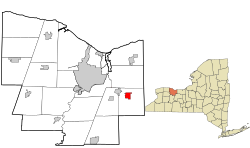
Fairport is a village in the town of Perinton, part of Monroe County, New York, United States. Fairport is a suburb of Rochester and is known as the "crown jewel of the Erie Canal".[3] The population of the village was 5,501 at the 2020 census.[4]
The town of Perinton was first settled in the two flat areas of Perinton Center (Turk Hill and Ayrault Roads) and Egypt. What was developed as the village of Fairport was a swampy area in the northern part of the town that was drained in the 1820s by construction of the new Erie Canal. With the opening of the canal, what was then known as Perrinsville quickly became a busy canal port with a reputation for being a "fair port".[3][5]
A further boon to the area's reputation as an industry and transportation center came with the construction of railroads in 1853.[3] This now booming section of Perrinsville was incorporated as a village on April 30, 1867, and eventually became the center of activity for the town of Perinton.[6]
In the 19th century, industry moved into Fairport, including Deland Chemical (baking soda), Cobb Preserving (the predecessor to American Can), and the Trescott Company (fruit grading and packing systems). Deland Chemical later became Fairport Vinegar Works, makers of Certo brand pectin used to gel and preserve foodstuffs.
In the early 20th century, the Erie Canal was expanded and renamed the Barge Canal. (It reverted to its original name in 1992).[7] Barge transportation rapidly declined as automobiles and trucks became popular. The town began to expand away from the canal. The Erie Canal is now used mainly for recreation.
Fairport acquired its name in the mid-19th century from a traveler on the Erie Canal who was overheard at Mallett's Tavern referring to the village as a fair port.[3] Local legend has it that the same visitor vociferously complained the next morning that Millstone Block Hotel had bedbugs, and he stormed out of Fairport, never to be seen again. The name, however, stuck. [citation needed]
Fairport is in eastern Monroe County, in the northern part of the town of Perinton. It is 10 miles (16km) southeast of downtown Rochester. New York State Route 31F passes through the village, leading west 2.5 miles (4.0km) to East Rochester and east 9 miles (14km) to Macedon. New York State Route 250 is Fairport's Main Street, continuing north 8 miles (13km) to Webster and south 4 miles (6km) to State Route 96 near the Victor town line.
According to the U.S. Census Bureau, the village of Fairport has a total area of 1.6 square miles (4.1km2), of which 0.04 square miles (0.10km2), or 2.29%, are water.[1] The water area is largely contained in the Erie Canal.
Although officially the name of only the village, "Fairport" is often used to refer to a large portion of the encompassing town of Perinton as well. Both the Fairport Central School District and Fairport ZIP code area overlap closely with the borders of Perinton.
As of the census[10] of 2000, there were 5,740 people, 2,369 households, and 1,594 families residing in the village. The population density was 3,645.0 inhabitants per square mile (1,407.3/km2). There were 2,431 housing units at an average density of 1,543.7 per square mile (596.0/km2). The racial makeup of the village was 96.99% White, 0.73% African American, 0.12% Native American, 1.03% Asian, 0.00% Pacific Islander, 0.21% from other races, and 0.92% from two or more races. 1.38% of the population were Hispanic or Latino of any race.
There were 2,369 households, of which 33.2% had children under the age of 18, 53.4% were married couples living together, 10.7% had a female householder with no husband present, and 32.7% were non-families. 27.0% of all households were made up of individuals, and 7.9% had someone living alone who was 65years of age or older. The average household size was 2.42 and the average family size was 2.96.
In the village, the population was spread out, with 25.2% under the age of 18, 6.1% from 18 to 24, 31.8% from 25 to 44, 25.1% from 45 to 64, and 11.8% who were 65years of age or older. The median age was 38years. For every 100 females, there were 92.4 males. For every 100 females age 18 and over, there were 91.1 males.
The median income for a household in the village was $53,375 and the median income for a family was $65,980. Males had a median income of $50,094 v. $30,431 for females. The per capita income for the village was $29,390. 3.3% of the population and 1.7% of families were below the poverty line. 2.2% of those under the age of 18 and 5.1% of those 65 and older were living below the poverty line.
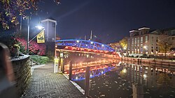
The Fairport Village Landing, opened in 1977, and Packett's Landing, built in the early 1980s, are two of the main shopping, dining and gathering spots in the village.
The Colonial Belle is a popular tour boat that offers canal cruises from Packett's Wharf on the Erie Canal in downtown Fairport.
Fairport Canal Days is an annual event featuring artists and performers.
Each Tuesday during the summer the village hosts live entertainment.
The Fairport Music and Food Festival occurs annually.
Parks and recreation
Kennelley Park
Perinton Park
Packett's Landing Wharf
Potter Park
Indian Hill Trail
Perinton Park is located on the banks of Erie Canal. There is a rowing boathouse nearby,[11] which holds a "Lift Bridge Regatta".[citation needed]
The Village Board is the local legislative body, consisting of the Mayor and four Trustees. Board members are elected in the November general elections and serve a term of four years.
The Village Board selects a Village Administrator with responsibility for directing Village operations, including those of the Fairport Municipal Commission and for serving as budget director, zoning officer and public safety officer.
Serving under the Village Administrator and appointed by the mayor with Board of Trustees approval, are the clerk/treasurer, deputy clerk, deputy treasurer and building inspector/fire marshal.[12]
Fairport Central School District oversee public education. Schools in Fairport include elementary schools Brooks Hill, Jefferson Avenue and Northside Dudley, middle schools Johanna Perrin and Martha Brown, and high schools Minerva Deland and Fairport High School.
Infrastructure
Fairport owns and operates a municipal power corporation, Fairport Electric.[13] Incorporated in 1901, Fairport Electric provides electric power to its customers at lower rates than those charged by neighboring utilities. Fairport Electric has purchased power from the New York Power Authority since 1961.[citation needed]
This page is based on this Wikipedia article Text is available under the CC BY-SA 4.0 license; additional terms may apply. Images, videos and audio are available under their respective licenses.