Riga, New York

Last updated
Riga
Motto: 
The First Pioneers of Monroe County
Monroe County New York incorporated and unincorporated areas Riga highlighted.svg
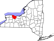
Location in Monroe County and the state of New York.
New York in United States (US48).svg
Location of New York in the United States
Coordinates: 43°04′10″N77°53′02″W / 43.06944°N 77.88389°W / 43.06944; -77.88389
CountryUnited States
State New York
County Monroe
EstablishedApril 8, 1808;215 years ago (1808-04-08) [1]
Government
   Town Supervisor Robert E. Ottley (R) First elected 2009
  • David L. Smith (R)
  • James S. Fodge (R)
  • Deborah S. Campanella (R)
  • Brad O'Brocta ()
Area
[2]
  Total35.23 sq mi (91.24 km2)
  Land34.96 sq mi (90.55 km2)
  Water0.27 sq mi (0.69 km2)
Elevation
577 ft (176 m)
Population
 (2010)
  Total5,590
  Estimate 
(2016) [3]
5,627
  Density160.95/sq mi (62.14/km2)
Time zone UTC-5 (EST)
  Summer (DST) UTC-4 (EDT)
ZIP code
14428
Area code 585
FIPS code 36-055-61808
Website https://www.townofriga.com/

Riga is a town in Monroe County, New York, United States. The population was 5,590 at the 2010 census.

Contents

The Town of Riga is southwest of the city of Rochester on the western border of the county. It is situated near the New York I-490. Locally, the town's name is pronounced RYE-ga, instead of REE-ga like the capital of Latvia.

Geography

According to the United States Census Bureau, the town has a total area of 35.3 square miles (91 km2), of which 35.2 square miles (91 km2) is land and 0.1 square miles (0.26 km2) (0.37%) is water.

Riga is bordered on the north by the town of Ogden, on the east by the town of Chili, on the west by Genesee County, and on the south by Genesee County and the town of Wheatland. Interstate 490 crosses the town.

Demographics

Historical population
CensusPop.Note
1820 3,139
1830 1,917−38.9%
1840 1,9843.5%
1850 2,1598.8%
1860 2,1770.8%
1870 2,171−0.3%
1880 2,2212.3%
1890 2,031−8.6%
1900 1,864−8.2%
1910 1,853−0.6%
1920 1,649−11.0%
1930 1,7184.2%
1940 1,669−2.9%
1950 1,90614.2%
1960 2,80046.9%
1970 3,74633.8%
1980 4,30915.0%
1990 5,11418.7%
2000 5,4376.3%
2010 5,5902.8%
2016 (est.)5,627 [3] 0.7%
U.S. Decennial Census [4]

As of the census [5] of 2000, there were 5,437 people, 1,969 households, and 1,518 families residing in the town. The population density was 154.6 inhabitants per square mile (59.7/km2). There were 2,018 housing units at an average density of 57.4 per square mile (22.2/km2). The racial makeup of the town was 97.26% White, 0.72% African American, 0.15% Native American, 0.74% Asian, 0.04% Pacific Islander, 0.09% from other races, and 1.01% from two or more races. Hispanic or Latino of any race were 0.92% of the population.

There were 1,969 households, out of which 39.1% had children under the age of 18 living with them, 64.9% were married couples living together, 9.1% had a female householder with no husband present, and 22.9% were non-families. 18.6% of all households were made up of individuals, and 7.6% had someone living alone who was 65 years of age or older. The average household size was 2.75 and the average family size was 3.15.

In the town, the population was spread out, with 28.3% under the age of 18, 6.1% from 18 to 24, 30.5% from 25 to 44, 25.6% from 45 to 64, and 9.6% who were 65 years of age or older. The median age was 38 years. For every 100 females, there were 99.2 males. For every 100 females age 18 and over, there were 93.5 males.

The median income for a household in the town was $58,842, and the median income for a family was $65,106. Males had a median income of $47,083 versus $31,202 for females. The per capita income for the town was $23,590. About 3.3% of families and 3.8% of the population were below the poverty line, including 2.3% of those under age 18 and 10.7% of those age 65 or over.

History

In the 18th century, the lands of present-day Riga were part of the "Mill Seat Tract" deeded by Native Americans to Phelps and Gorham. Soon thereafter, Robert Morris of Philadelphia acquired the land and sold it to the estate of Sir William Pulteney, 5th Baronet in England.

The Riga area was originally part of Ontario County, set up by the State Legislature in 1789. It later became part of Genesee County. The first organized town between the Genesee River and Lake Erie was Northampton. In 1802, Northampton was divided into Leicester, Batavia, Southampton, Northampton, and East and West Pulteney - after Sir William Pulteney. In 1808 East and West Pulteney became East and West Riga, and in 1809 the Town of Riga was formed.

The Riga Academy was listed on the National Register of Historic Places in 1980. [6]

Government

Riga town hall Riga, New York town hall.jpg
Riga town hall

The town is governed by a Town Board consisting of a Town Supervisor and four Council members, all elected by registered town voters.

Communities and locations in Riga

Related Research Articles

Belmont is a village within the town of Amity in Allegany County, New York, United States. Belmont is the county seat of Allegany County. The population was 969 at the 2010 census. The name means "beautiful hill". The village is centrally located in Amity and is northeast of Olean.

Genesee is a town in Allegany County, New York, United States. The population was 1,653 at the 2020 census. Genesee is in the southwestern corner of the county, southeast of Olean.

<span class="mw-page-title-main">Stafford, New York</span> Town in New York, United States

Stafford is a town in Genesee County, New York, United States. The population was 2,459 at the 2010 census. The town was named after a town of the same name in England.

<span class="mw-page-title-main">Chili, New York</span> Town in New York, United States

Chili is a town in Monroe County, New York, United States. The population was 29,123 at the 2020 census. It is a suburb of the city of Rochester.

<span class="mw-page-title-main">Churchville, New York</span> Village in New York, United States

Churchville is a village in Monroe County, New York, United States. According to the 2010 census, the population was 1,961. The village is named after Samuel Church, an early settler.

<span class="mw-page-title-main">Henrietta, New York</span> Town in New York, United States

Henrietta is a town in Monroe County, New York, United States and a suburb of Rochester. The population of Henrietta is 47,096, according to the 2020 United States Census. Henrietta is home to the Rochester Institute of Technology and to one of the largest retail shopping districts in Monroe County.

<span class="mw-page-title-main">Ogden, New York</span> Town in New York, United States

Ogden is a town in Monroe County, New York, United States. The population was 19,856 at the 2010 census.

<span class="mw-page-title-main">Parma, New York</span> Town in New York, United States

Parma is a town in Monroe County, New York, United States. The population was 15,633 at the 2010 census.

<span class="mw-page-title-main">Wheatland, New York</span> Town in New York, United States

Wheatland is a town in Monroe County, New York, United States. The population was 4,775 at the 2010 census. The town is home to Genesee Country Village and Museum.

Prattsburgh is a town in Steuben County, New York, United States. The population was 1,985 at the 2020 census. It is situated in the northeast part of the county, north of Bath.

Pulteney is a town in Steuben County, New York, United States. The population was 1,260 at the 2020 census. The name is derived from the name of the original pioneer tract of land.

Troupsburg is a town in Steuben County, New York, United States. The population was 1,016 at the 2020 census. The town is named after Robert Troup, an agent of the Pulteney Estate.

<span class="mw-page-title-main">Genesee Falls, New York</span> Town in New York, United States

Genesee Falls is an incorporated town in Wyoming County, New York. The population was 438 at the 2010 census.

<span class="mw-page-title-main">Churchville, Pennsylvania</span> Census-designated place in Pennsylvania, United States

Churchville is a census-designated place (CDP) in Northampton Township, Bucks County, Pennsylvania. The population was 4,128 at the 2010 census.

<span class="mw-page-title-main">Northampton Township, Bucks County, Pennsylvania</span> Township in Pennsylvania, United States

Northampton Township is a township in Bucks County, Pennsylvania. The township is located approximately 12 miles northeast of Philadelphia. The population was 39,726 at the 2010 census.

<span class="mw-page-title-main">Richboro, Pennsylvania</span> Census-designated place in Pennsylvania, United States

Richboro is a census-designated place (CDP) in Northampton Township, Bucks County, Pennsylvania, United States. The population was 6,378 during the 2020 census.

<span class="mw-page-title-main">Forks Township, Northampton County, Pennsylvania</span> Place in Pennsylvania, United States

Forks Township is a township in Northampton County, Pennsylvania. The population of Forks Township was 14,721 as of the 2010 census. It is part of the Lehigh Valley metropolitan area, which had a population of 861,899 and was the 68th-most populous metropolitan area in the U.S. as of the 2020 census. The township is home to the global headquarters of Crayola, founded in 1885, a global arts supply company and the world's leading manufacturer of crayons.

<span class="mw-page-title-main">Genesee Township, Potter County, Pennsylvania</span> Township in Pennsylvania, United States

Genesee Township is a township in Potter County, Pennsylvania, United States and lies near the source of the Genesee River. The population was 729 at the 2020 census. The name Genesee derives from Indian term for "beautiful valley".

<span class="mw-page-title-main">Caledonia, New York</span> Town in New York, United States

Caledonia is a town in Livingston County, New York, United States. The population was 4,255 at the 2010 census. The town contains the village of Caledonia. The town is in the northwestern part of the county and is southwest of Rochester. It is part of the Rochester metropolitan area.

Portage is a town in the southwest corner of Livingston County, New York, United States. The town is at the south end of Letchworth State Park. The name of the town stems from the need to portage (carry) canoes around the falls of the Genesee River. The population of Portage was 884 at the 2010 census.

References

  1. Hanford, Franklin (1911). On the origin of the names of places in Monroe County, New York (PDF). Scottsville, New York: Isaac Van Hooser. p. 11. OCLC   866011722 . Retrieved December 2, 2021.
  2. "2016 U.S. Gazetteer Files". United States Census Bureau. Retrieved Jul 5, 2017.
  3. 1 2 "Population and Housing Unit Estimates" . Retrieved June 9, 2017.
  4. "Census of Population and Housing". Census.gov. Retrieved June 4, 2015.
  5. "U.S. Census website". United States Census Bureau . Retrieved 2008-01-31.
  6. "National Register Information System". National Register of Historic Places . National Park Service. July 9, 2010.