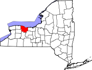
Adams Basin, New York | |
---|---|
Coordinates: 43°11′50.84″N77°51′14.01″W / 43.1974556°N 77.8538917°W | |
Country | United States |
State | New York |
County | Monroe |
Elevation | 502 ft (153 m) |
Time zone | UTC-5 (Eastern (EST)) |
• Summer (DST) | UTC-4 (EDT) |
ZIP code | 14410 |
Area code | 585 |
GNIS feature ID | 942160 [1] |
Adams Basin is a hamlet in Monroe County, New York, United States. [1] The hamlet is the location of the Adams-Ryan House, a historic Erie Canal inn listed on the National Register of Historic Places in 1985 and was operated as a bed and breakfast. [2]
Adams Basin is located in the northwestern corner of the town of Ogden. Though fully surrounded by the Spencerport zip code of 14559, the hamlet has its own post office with zip code 14410. Adams Basin is within the Brockport Central School District.
Chenango Forks is a hamlet located in Broome County, New York, United States. The community is situated partly in the town of Chenango and partly in the town of Barker.
Irving is a hamlet in Chautauqua County, New York, United States. It is located near the eastern town line and the eastern county line in the town of Hanover. U.S. Route 20 and New York State Route 5 pass through the hamlet, which is next to Cattaraugus Creek; New York State Route 438 terminates just across the creek. The elevation of the hamlet is 584 feet (178 m) above sea level. The ZIP Code for Irving is 14081.
Ontario Center is a hamlet in the Town of Ontario, Wayne County, New York, United States. It is located one mile (2 km) west-northwest of the hamlet of Ontario, at an elevation of 449 feet. The primary intersection in the hamlet is at N.Y. Route 350 and Ridge Road. N.Y. Route 104 passes just north of Ontario Center.
Deansboro is a hamlet in Oneida County, New York, United States.
Olivebridge is a hamlet in the town of Olive, Ulster County, New York, United States, within Catskill Park and the Catskill Mountains.
Bedford Corners is a hamlet in the Westchester County town of Bedford, New York, United States, northeast of the town of Mount Kisco, with which it shares a post-office and zip code. The area is very hilly with rocky terrain and substantial native hardwood deciduous trees.
Lew Beach is a hamlet in the town of Rockland, New York, United States. It is at the northernmost corner of the town and thus also of Sullivan County, near the tripoint with Delaware and Ulster counties, within the Catskill Park. Its ZIP code, 12758, extends into the neighboring sections of the latter county's town of Hardenburgh, and some of those areas are considered part of Lew Beach as well.
Fly Creek is a non-incorporated hamlet three miles west of the Village of Cooperstown on conjoined NY-28/NY-80, in the Town of Otsego, in Otsego County, New York, United States. The zipcode is 13337. The Fly Creek Cider Mill and Orchard is located by the hamlet.
Piffard is a census-designated place (CDP) and hamlet in the town of York, Livingston County, New York, United States. As of the 2010 census, its population was 220. The ZIP Code is 14533.
Ferndale is a hamlet in the Town of Liberty, Sullivan County, New York, United States. It is situated along the old alignment of New York Route 17 between Harris and Liberty. The zip code is 12734.
Halcottsville is a hamlet in the town of Middletown, Delaware County, New York, United States, on the south shore of Wawaka Lake. It was named for John Halcott (1758-1831), a Revolutionary War soldier from Delaware County. He resided with his son Thomas in Halcottsville until his demise. Halcottsville is located on the East Branch Delaware River and New York State Route 30 5.6 miles (9.0 km) northeast of Margaretville. Halcottsville has a post office with ZIP code 12438. The hamlet has a stop on the excursion Delaware & Ulster Railroad which originates in nearby Arkville and extends north to the village of Roxbury.
East Palmyra is a hamlet in the Town of Palmyra, Wayne County, New York, United States near the Arcadia town line. It is located five miles (8 km) northeast of the Village of Palmyra and 5 miles (8 km) northwest of the Village of Newark, at an elevation of 443 feet. The primary cross roads where the hamlet is located are Tellier Road, South Creek Road and East Palmyra-Port Gibson Road.
Spencertown is a hamlet in the town of Austerlitz, Columbia County, New York, United States. Its ZIP code is 12165.
Springfield Center is a hamlet in the town of Springfield, Otsego County, New York, United States. According to the 2010 US census, The location of Springfield Center had a population of 402. Springfield Center is located on New York State Route 80, 9.2 miles (14.8 km) north-northeast of the Village of Cooperstown. Springfield Center has a post office with ZIP code 13468, which opened on July 16, 1850.
Charlotteville is a hamlet in the town of Summit, Schoharie County, New York, United States. Charlotteville is 8 miles (13 km) southwest of Richmondville. The community has a post office with ZIP code 12036.
Sodus Center is a hamlet in the Town of Sodus, Wayne County, New York, United States. It is located four miles (6 km) southeast of the Village of Sodus, at an elevation of 417 feet. The primary cross roads where the hamlet is located are Sodus Center Road, Barclay Road and Main Street.
Hunt is a hamlet and census-designated place (CDP) in Livingston County, New York, United States. Its population was 78 as of the 2010 census. Hunt has a post office with ZIP code 14846.
North Chatham is a hamlet in Columbia County, New York, United States. The community is located along New York State Route 203 3.2 miles (5.1 km) south-southwest of Nassau and 4.9 miles (7.9 km) north-northeast of Valatie. North Chatham has a post office with ZIP code 12132.
South Colton, also referred to as Three Falls, is a hamlet located in the Town of Colton in St. Lawrence County, New York, on NY 56 by the crossing of the Raquette River. Located in South Colton is Sunday Rock, a historic glacial erratic. South Colton has a post office with ZIP code 13687, which opened on November 15, 1854.
Vernon Center is a hamlet in Oneida County, New York, United States. The community is located at the intersection of state routes 26 and 31, 2.7 miles (4.3 km) southeast of the village of Vernon. Vernon Center has a post office with ZIP code 13477, which opened on January 16, 1823.